Showing 7090 items matching "snowy-river"
-
 National Wool Museum
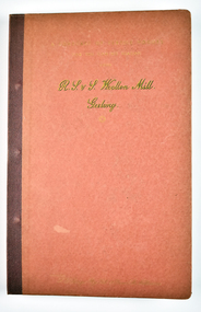
Book - A Forecast of the textile vogues for the coming season from R. S. & S. Woollen Mill, Geelong Part IV, Returned Soldiers and Sailors Mill, 1941
The Returned Soldiers and Sailors Mills was located near the Barwon river on Pakington Street, Geelong, where its building still stands. The mill was established in October 1922 with capital acquired from War Gratuity Bonds. The mill produced fine grade woollen products with its speciality being ‘Retsol’ travelling rugs.31 page red book bound with metal pins containing fabric samples glued onto paper, with some printed text.cover: [printed] A FORECAST OF TEXTILE VOGUES / FOR THE COMING SEASON / FROM / R. S. & S. Woollen Mill. / Geelongr. s. & s mill, soldiers, sailors, geelong, war, wool, mill -
 National Wool Museum
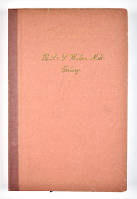
Book - A Forecast of the textile vogues for the coming season from R. S. & S. Woollen Mill, Geelong Part 1, Returned Soldiers and Sailors Mill, 1941
The Returned Soldiers and Sailors Mills was located near the Barwon river on Pakington Street, Geelong, where its building still stands. The mill was established in October 1922 with capital acquired from War Gratuity Bonds. The mill produced fine grade woollen products with its speciality being ‘Retsol’ travelling rugs.25 page red book bound with metal pins containing fabric samples glued onto paper, with some printed text.cover: [printed] A FORECAST OF TEXTILE VOGUES / FOR THE COMING SEASON / FROM / R. S. & S. Woollen Mill. / Geelongr. s. & s mill, soldiers, sailors, geelong, war, wool, mill -
 Ringwood and District Historical Society
Map, Plan of the Parish of Warrandyte County of Evelyn - 1841
Blueprint copy of Survey Map W27 detailing original Selectors' names and property locations between Yarra Yarra River (Warrandyte) and Mullum Mullum Creek (Ringwood). List of Parish map references including property bearings, distances in Links, and markings on trees. Pound Bend area of Warrandyte marked as Reserve For Aborigines. Descriptive remarks include areas marked "scrubby, flat, sandy soil". Several other references faded and illegible.(Map) by T.H. Nutt Feb 3 1841. -
 City of Moorabbin Historical Society (Operating the Box Cottage Museum)
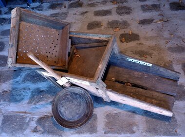
Functional object - Gold Mining, prospector's "rocker", c1870
Gold was discovered in Victoria c1850 and people came from all over the world to seek their fortune at Ballarat and Bendigo and surrounding gold fields. This large wooden rocking- box or cradle was used by gold prospectors. A handle on the rocker is pushed back and forth, as the miner put gravel into the top part and finer and heavier particles dropped through a screen, helped along by buckets of water. The bottom part of the device had slats, that caught the heavier metals. After many shovel loads of gravel were pushed through the rocker, the miner would then use his gold pan to sort out the heavy minerals to find gold. Most of the pioneer settlers in Moorabbin Shire left the area to try their luck at gold mining and there was a desperate shortage of workers to maintain the market gardens and supply food to the ever increasing population of Melbourne.This gold prospector's 'cradle' is hand made and typical of those used by many hopeful Moorabbin Shire pioneers as they abandoned their market gardens to try their luck at finding gold in the Ballarat and Bendigo minefields c1850This gold miner's rocker is very old, and very well-used. It is a large wooden rocking- box or cradle used by gold prospectors. A handle on the rocker is pushed back and forth, as gravel is put in the top part of the box so that finer and heavier particles drop through a screen.. The bottom part of the device had slats, that caught the heavier metals. i.e gold particles. The water passed through the shute at the base back into the creek or river.moorabbin, brighton, market gardens, pioneers, early settlers, fruit, vegetable, ballarat, bendigo, gold mining, gold prospedtors, gold rush, were j. b., irish immigrants, chinese immigrants, gold panning, gold digger -
 Bendigo Historical Society Inc.
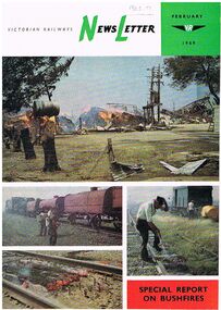
Document - BADHAM COLLECTION: NEWSLETTER FEBRUARY1969 SPECIAL REPORT ON BUSHFIRES
Victorian Railways Newsletter February 1969 Special report on bushfires. Glossy paper with colour photos on front of bushfires in relation to railway property. The contents include photos of effects of the fire to VR property, closure of State coal mines, photos of fire destroyed bridge at Diamond Creek, Molesworth, the Powlett River Coal Field in 1910 (Wonthaggi), and Kirrak Mine. Printed at the Victorian railways printing works Laurens St North Melbourne.magazine, government, victorian railways, victorian railways newsletter / photos of effects of the fire to vr property/ closure of state coal mines / photos of fire destroyed bridge at diamond creek / molesworth/ the powlett river coal field in 1910 ( wonthaggi) / kirrak mine / printed at the victorian railways printing works laurens st north melbourne -
 Bendigo Historical Society Inc.
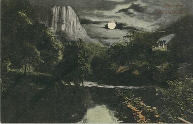
Postcard - GLADYS DEAN COLLECTION: POSTCARD, 1906 - 1908
Printed coloured postcard. Image is of High Tor Matlock Bath and has a textured surface. It depicts a rocky tor by moonlight over a river. A cottage is on the right hand bank. The words High Tor Matlock Bath are printed in red in the top right hand corner. The reverse is addressed to Miss Dean "Esmond" Golden Square and has a one penny stamp affixed . The words Valentines Moonlight Series appear on the left hand edge.Valentines Moonlight Seriespostcard -
 Bendigo Historical Society Inc.
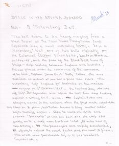
Document - ARTICLES FOR ROYAL HISTORICAL SOCIETY (BENDIGO BRANCH) NEWSLETTER TO MARCH 1973)
Articles for Royal Historical Society (Bendigo Branch) Newsletter - March 1973). 1. ''Bells in and around Bendigo - No. 4: A 'Schomberg Bell' '' - bell of Twin Rivers Presbyterian Camp, Eppalock with history from wreck of the 'Schomberg' (Warrnambool, 1855); mention of St. Andrews, Bendigo and Bendigo fire bell (pro tem). 2. Handwritten version of ''Bendigo City Coat of Arms'' (see Mosaic 6550 for description). 3. Typewritten version of 1. abovedocument -
 Ballarat Tramway Museum
Document - Photocopy, Jim Longworth and Grant Fleming, 'Mellor's Meadowbank Manufacturing Company Tramway', Oct. 1998
Photocopy of a three page article relating to the light railway that ran from Parramatta River Sydney to Mellor's Meadowbank factory, that appeared in 'Light Railways' magazine No. 143 of Oct. 1998, pages 3 to 5. Included in article is a stylised illustration of the factory and its location, photographs of two surviving Meadowbank Manufacturing Builders plates from NSWGT tramcars (J class and P 1667). Site now part of Meadowbank TAFE college.trams, tramways, meadowbank, tramcar manufacture, light railways, railway vehicle manufacture -
 Bendigo Historical Society Inc.
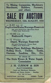
Document - IAN DYETT COLLECTION: AUCTION CATALOGUE - WARANGA RESERVOIR
Two pale green auction catalogue with black printing on the cover for a sale on the 15th August, 1934 at the Duplication Works, Waranga Reservoir, Rushworth Depot and the Depot, Waranga Reservoir, by order of The State Rivers & Water Supply Commission. For sale is Mining Plant, Buildings, Machinery, Rolling Stock, Timber, Tanks, Harness Sundries, etc. Some notes and prices written in one catalogue. Catalogues have columns on the right of the page for £, S & D to be noted.business, auctioneers, j h curnow & son pty ltd, ian dyett collection - auction catalogue - waranga reservoir, the state rivers & water supply commission, j h curnow & son, boltons print bendigo -
 Bendigo Historical Society Inc.
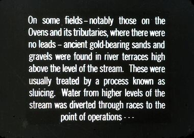
Slide - DIGGERS & MINING. GETTING THE GOLD, c1850
Diggers & Mining. Getting the Gold. Slide: On some fields - notably those on the Ovens and its tributaries, where there were no leads - ancient gold-bearing sands and gravels were found in river terraces high above the level of the stream. These were usually treated by a process known as sluicing. Water from higher levels of the stream was diverted through races to point of operations . . . Markings: 59 994.LIF:4. Used as a teaching aid.hanimounteducation, tertiary, goldfields -
 Kew Historical Society Inc
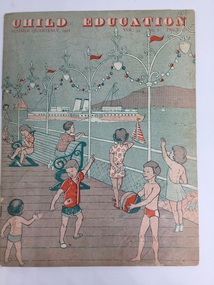
Magazine - Periodical, Messrs Evans Bros Ltd, Child Education : Summer Quarterly, 1958, Vol. 35 No. 7, 1958
The Child's Education magazines were published for British teachers between 1924 and 2007 to help them plan activities for the season ahead. The internal pages contain a variety of lesson ideas in the form of a music, art or craft activities. This copy was donated to the Kew Historical Society's collection by the Preshil archives.This 1958 periodical, sourced from the Preshil School. is interesting as it represents the continuing influence of English education and culture in the Australian curriculum in the late 1950s.20 page newsletter containing artwork and articles on the theme shipping and boats. Text on page 3 describes the subject of the issue as 'Around our Coasts'. This is amplified by the text as: "In preparation for the children's seaside holiday, descriptions and pictures of ships, boats and lighthouses, and their work are contained in this issue. Suggestions for handwork are also given. The wall picture [not included with this item] in full colour illustrates many different ships which the children might see at the seaside or on a river estuary."periodicals -- child education uk, themes -- shipping and boats, messrs evans bros ltd -
 Kew Historical Society Inc
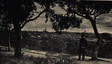
Photograph - Urban landscape, Henry Beater Christian, 1930s
Henry Christian (c.1809-91), the grandfather of the photographer, was one of the first settlers in Kew. He arrived in Victoria with his wife Agnes and son Orlando in 1855 on the Gypsy Queen. He established a rope-making business in Bulleen Road by 1858 but was declared insolvent two years later. In his final years, he was celebrated as one of the oldest living settlers of the district. His son, Orlando Henry Beater Christian (c.1853-1930) became a member of the Hawthorn Band and a foundation member of the Willsmere Swimming Club. Orlando and his wife Elizabeth had four children of which Henry Beater Christian (1886-1962) was the eldest.An item from an outstanding and diverse photographic collection, assembled by members of the Christian family of Pakington Street, Kew, comprising professional and amateur photography, depicting individuals, natural and settled environments and the interactions between these worlds. Many of the photographs vividly capture the worlds of three generations of men - Henry Christian, his son Orlando Henry Beater Christian, and his grandson of Henry Christian. The most important photographer was the youngest, Henry Christian, who was a keen explorer, not just of his immediate environment but also of the Victorian wilderness. His major opus is contained in two albums in which he records, sometimes in majestic detail and on other occasions the intimate features of the natural world. His photographic travels during the 1920s, often in solitary ramblings but on other occasions with companions, recall the heroic landscape photography of an earlier era, pioneered by Nicholas Caire. In addition to their aesthetic value, the albums are historically significant records within the State of Victoria, of what is now a distant point in time, and of places that have become radically altered through human intervention.Black and white photo of the rear view of a man in a hat standing under a tree on a hill looking across the Yarra River (unseen) towards Melbourne. The exhibition building and the spires of St Patrick’s Cathedral can be seen on the skyline. The man may be Orlando Henry Beater Christian. If all the spires are intact it must postdate 1939 when work begun in the early 1930s on the spires began. He may be standing on the edge of the Yarra Boulevard.melbourne skyline - 1930s, yarra boulevard -- kew (vic.), christian-washfold collection -
 University of Melbourne, Burnley Campus Archives
Plan, Royal Horticultural Society's Garden
Changed boundaries of the site burnley gardens, survey paddock, flood, lynch design, richmond park, yarra river -
 Melbourne Tram Museum
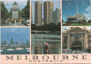
Postcard, Steve Parish Paddington Qld, Five views of Melbourne with trams, 1990
Postcard - full colour, Divided back type of six views of five views of Melbourne of St Kilda Road with trams, Rowing on the Yarra River with the city skyline in the background, The Arts Centre, Flinders St station and a view from Williamstown back to the CBD. Has title "Melbourne Australia" on the underside of the photos. Steve Parish production, 1990, produced in Paddington Qld. Has logo, position for stamp and address on the rear and number PC 308.trams, tramways, melbourne, shrine of remembrance, flinders st station, arts centre -
 Melbourne Tram Museum
Slide - Set of 2, John Webster, 14/06/1960 12:00:00 AM
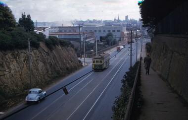
Set of two Colour slides Kodak, white cardboard of trams: .1 - an SW6 (route 42) car descending the Barkers Road hill through the cutting towards Victoria Bridge over the Yarra river, Has the Vickers Ruwolt factor in the background and the city skyline. .2 - SW6 893 (City Route 42), crossing the Victoria Bridge after leaving the Barkers Road cutting. Shows the overhead support structure on the bridge. Slide datedHand writing on rear in ink "14-6-60 - Retrieving a trolley pole Church St Hawthorn."trams, tramways, route 42, barkers road, sw6 class, bridges, victoria bridge, tram 893 -
 Melbourne Tram Museum
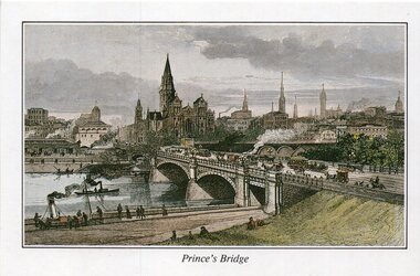
Drawing - Illustration, St Paul's Cathedral, "Engraving of Prince's Bridge and St Paul's Cathedral, Melbourne 1889", 1992
Illustration - colour engraving printed onto white card, titled "Princes Bridge" showing the planned St Paul's Cathedral, Flinders St Station, Princes bridge with cable trams and the Yarra River with steam powered boats. On rear - "Engraving of Prince's Bridge and St Paul's Cathedral, Melbourne 1889" with a note that it was drawn before the completion of the cathedral the design shows in that intended by the Architect, William Butterfield and that it was from the collection of St Paul's Cathedral.trams, tramways, yarra river, st pauls cathedral, melbourne, greetings cards -
 Bendigo Historical Society Inc.
Document - CONNELLY, TATCHELL, DUNLOP COLLECTION: LEGAL PAPERS, 1902 - 1910
Document. Various legal papers. 1 - 1903 Richardson, Mr J re costs. 2 - 1902 Wishart to Neill, note. 3 - 1908 Stritch, Paytrick & William - Farmers, Mincha, re costs. 4 - 1910 The State Rivers & Water Supply Commission, re Lethlean Sarah, Bunning Sarah, Bunning R . L. and Mountjoy J. re costs. 1908 - Bailey, Mr Chas, Farmer Pompapiel. Statement re costs.bendigo, business, connelly tatchell and dunlop, connelly, tatchell & dunlop, richardson mr j, wishart to neill, stritch patrick & william, state rivers & water supply commission, lethlean sarah, bunning sarah, bunning r. l., mountjoy j, bailey mr chas -
 Lakes Entrance Historical Society
Postcard - SS Wyrallah, SS Manawatu, c1910
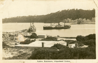
Sepia toned postcard showing view of New Works buildings at north end of eastern pier. Cunninghame Arm in front of buildings, Reeves River left in distance. SS Wyrallah steaming past, and SS Manawatu at pier. Jemmy's Point, Mt Barkly, and Kalimna hills in background. Photo taken from top of dune. Smoke issuing from SS Wyrallah funnel. Carstairs boarding house in centre foreground. Lakes Entrance VictoriaLakes Entrance - Gippsland Lakes ships and shipping, piers, historic site -
 Ringwood and District Historical Society
Newspaper, Scrapbook Clipping, Library Collection, Ringwood, Victoria
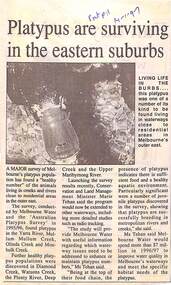
Newspaper Clipping from "The Post", 14 January 1997, Page 11, "Platypus are surviving in the eastern suburbs"'.A major survey of Melbourne's platypus population has found a "healthy number" of the animals living in creeks and rivers close to residential area in the outer east. Conservation and Land Management Minister, Marie Tehan, was present at the launching of the survey results, and spoke in detail about the results and the future planning and financial aid for the health of the Melbourne waterways. -
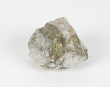 The Beechworth Burke Museum
Geological specimen - Pyrite
This specimen was recovered from Adelong, NSW. The initial discovery of gold at Adelong by a Mr Williams took place in 1857. Much of the area is underlain by granitic rocks, while at Adelong itself a prominent norite intrusive body occurs. To the west of Adelong is a belt of intermediate to mafic igneous rocks and sediments which extends from Batlow in the south to at least as far north as the Snowy Mountains Highway. Around 26 tonnes of gold was found at the Adelong goldfield from its discovery in the 1850s until the last miners left in the 1940s. Pyrite has the formula of FeS2 and forms as an isometric (cube) form. It is a common occurring material and is often mistaken for gold, now colloquially known as ‘fool’s gold’. Pyrite that has strongly crystallised is considered stable, but the mineral has the potential to oxidise and decay. This specimen is part of a larger collection of geological and mineral specimens collected from around Australia (and some parts of the world) and donated to the Burke Museum between 1868-1880. A large percentage of these specimens were collected in Victoria as part of the Geological Survey of Victoria that begun in 1852 (in response to the Gold Rush) to study and map the geology of Victoria. Collecting geological specimens was an important part of mapping and understanding the scientific makeup of the earth. Many of these specimens were sent to research and collecting organisations across Australia, including the Burke Museum, to educate and encourage further study.Pyrite is iron sulphide (also known as “fool's gold”) which is commonly found in slates.Existing Label: 104 /burke museum, beechworth, indigo shire, beechworth museum, geological, geological specimen, mineralogy, pyrite, adelong -
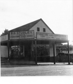 Greensborough Historical Society
Photograph - Digital image, Stubley's Furniture, 1958c
Stubley's Furniture Store late 1950s. The Stubley Group began in 1946 when Purcell Stubley purchased a site with petrol bowsers in Main Street from 'Snowy' Jessop. In 1948 Purcell began building the new Stubley Motors, working round the old site to keep the business operating. It was completed in 1951. The Group expanded into other areas such as this Furniture store. [Syd Thompson Fruit Shop was here in early 1950s, Syd lived in the house at back. He coached Boxing]. This became the Welkay Store in the 1960's and owned by Walter Kenyon. The Welkay store moved opposite to 100 Main Road on 6/9/1966, ref: Diamond Valley News Page 9. Soon after the store would have been demolished to make way for 'The Valley Building' still on the site in 2018.Digital copy of black and white photographpurcell stubley, stubley motors, stubley group greensborough -
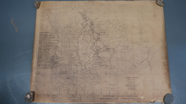 Kiewa Valley Historical Society
Map - Kiewa Scheme General Plan
Existing and possible future roads are numbered and named 1 - 45. The plan is based on an aerial photos taken March 1945. It includes revisions up to 1951. Signed by H.H.C. Williams, construction engineer. Mountains, rivers, roads and SECV places are named, also SECV infrastructure and construction eg. workers camps, Power stations.Significant for the information re the Kiewa Hydro Electric Scheme's development.Yellowed paper with brown print. Kiewa Scheme general plan showing its development. A lot of information is recorded. Note: Dyeline print was used which causes fading when exposed to light. Handwritten: 'Bob Duncan'bob duncan, kiewa hydro electric scheme, secv, khes development -
Eltham District Historical Society Inc
Document - Folder, Murphy, James and descendants
James Murphy was a mining surveyor involved with the Caledonia diggings. Contents Note from Ray Blake, 26 April 2000: Ms Murphy said her people had traditionally owned all of inner Melbourne, north to the Great Divide, West to Werribee River, East to Mt Baw Baw, South to Mordialloc Creek.Newspaper clippings, A4 photocopies, etcjames murphy -
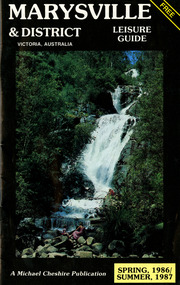 Marysville & District Historical Society
Booklet (Item) - Leisure guide, Michael Chesire & Associates Pty. Ltd, MARYSVILLE & DISTRICT LEISURE GUIDE-SPRING, 1986/SUMMBER, 1987, 1986
A free leisure guide to Marysville and the surrounding district published for Spring 1986, and Summer, 1987. This was produced by Michael Cheshire as a free publication to promote tourism in Marysville and the surrounding district. It includes maps of the Big River Valley, Cumberland Valley, Lady Talbot Forest Drive, the Marysville area, and the township of Marysville. It was released in the spring of 1986. A free leisure guide to Marysville and the surrounding district published for Spring 1986, and Summer 1987.Kilmore Historical Society *10/183 *MDL.1.marysville, victoria, australia, leisure guide, michael cheshire & associates pty ltd, marysville golf club, blackwood lodges, sir colin mackenzie fauna park, lake eildon, fraser national park, yarra valley wineries, marysville coach tours, kooringa, marylands guest house, lady talbot forest drive, wishing well, taggerty river recreation area, athols abbey, phantom falls, keppel falls, the beeches walking track, marylyn guest house, kufstein inn motel, the cumberland, marysville tourist & progress association, marysville newsagency & general store, crossways restaurant & motel, beauty spot walk, tree fern gully walk, michaeldene track, keppel track, woods lookout track, marysville hotel motel, lake mountain ski hire, marysville recreation and fun park, mytanta horseback safaris, upper big river valley, the big culvert, marysville mountain view horse hire, maryton park, amber view holiday lodges, cathedral restaurant, the top shop, tower motel, menzes garage, beauty spot nursery, marysville ski hire, lake mountain ski school, faraway forest, scenic motel, buxton trout farm, marysville hardware, timbertop steakhouse, marysville trout farm, healesville sanctuary, buxton hotel motel, nanda binya lodge, buxton antique and furniture mart, the black spur inn hotel, alexandra, lake mountain, j l gould sawmills pty. ltd., geoffrey pope & associates, marysville crafts & gifts, olde yarra track shoppe, cumberland scenic reserve, tudor lodge road house, fruit salad farm, highwayman's retreat -
 Greensborough Historical Society
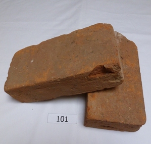
Functional object - Bricks, Hand made bricks from Partington house (Willis Vale) Greensborough, 1840c
Bricks from "Willis Vale' home of the Partington family of Greensborough. Built in 1840, Willis Vale was owned by the Partington family from 1878 to 1947. It was a 2 storey house overlooking the Plenty River and set in 150 acres of farmland. The Partingtons moved out in 1947 and the house was vandalised shortly after. It was destroyed by fire in the 1960s.The bricks are a link to pioneer homes and farms in the area.Hand made clay bricks, light red in colour. All faces are flat.. One brick is chipped. Accompanying note: Hand made bricks from Partington house in Greensborough. Donated by Alan Partington.willis vale, partington family, greensborough, alan partington, bricks -
 Greensborough Historical Society
Book, Nillumbik Shire Council, 1997 Community Guide Nillumbik, 1997_
Guide to services provided by Nillumbik Shire Council. Nillumbik Shire is located 25 kilometres north-east of Melbourne and the southern boundary is the Yarra River. The south of Nillumbik is predominantly urban, with commercial centres at Eltham and Diamond Creek. The north of the municipality includes significant natural features like Kinglake National Park and Sugarloaf ReservoirAnnual guide to services in Nillumbik. 64 pages. Cover is pale yellow with colour drawings. nillumbik shire council, handbooks -
 Greensborough Historical Society
Book, Nillumbik Shire Council, 1998 Community Guide Nillumbik, 1998_
Guide to services provided by Nillumbik Shire Council. Nillumbik Shire is located 25 kilometres north-east of Melbourne and the southern boundary is the Yarra River. The south of Nillumbik is predominantly urban, with commercial centres at Eltham and Diamond Creek. The north of the municipality includes significant natural features like Kinglake National Park and Sugarloaf ReservoirAnnual guide to services in Nillumbik 72 pages. Cover has white background and some 3-D artwork.nillumbik shire council, handbooks -
 Greensborough Historical Society
Book, Nillumbik Shire Council, 1999 Community Guide Nillumbik, 1999_
Guide to services provided by Nillumbik Shire Council. Nillumbik Shire is located 25 kilometres north-east of Melbourne and the southern boundary is the Yarra River. The south of Nillumbik is predominantly urban, with commercial centres at Eltham and Diamond Creek. The north of the municipality includes significant natural features like Kinglake National Park and Sugarloaf ReservoirAnnual guide to services in Nillumbik76 pages, illus. Cover has photographs of local people and title in white on orange background.nillumbik shire council, handbooks -
 Greensborough Historical Society
Book, Nillumbik Shire Council, Nillumbik Community Guide 2000/2001, 2000-2001
Guide to services provided by Nillumbik Shire Council. Nillumbik Shire is located 25 kilometres north-east of Melbourne and the southern boundary is the Yarra River. The south of Nillumbik is predominantly urban, with commercial centres at Eltham and Diamond Creek. The north of the municipality includes significant natural features like Kinglake National Park and Sugarloaf ReservoirAnnual guide to services in Nillumbik76 pages, black and white illustrations. Cover has a collage of local children with title in white on mid-blue background.nillumbik shire council, handbooks -
 Greensborough Historical Society
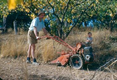
Photograph - Digital Image, Blackjack: Frank Robinson hoeing, 1953_
Frank Robinson hoeing the apricot orchard at Blackjack with son Andrew in rear. The Blackjack property, house and acres of fruit orchards ran down to the Plenty River off Hume Street Greensborough and was the home of the Robinson family to late 1956. The photographs were taken as slides by Frank Robinson and digitised by his son James in 2015.Digital copy of colour photograph.frank robinson, blackjack