Showing 9739 items
matching west
-
 Melbourne Tram Museum
Ephemera - Timetable, Melbourne & Metropolitan Tramways Board (MMTB), Set of 13 Timetables MMTB, Oct 1966 to July 1969
Set of 13 Timetables - printed or photocopied on foolscap paper for weekdays, Saturdays and Sunday and running times. Has various symbols for depot run in etc. In a style for public use. All to the City unless noted. .1 - North Richmond - Prahran - St Kilda Beach - June 1969 .2 - Essendon Aerodrome - Nov. 1968 .3 - East Preston - July 1969 .4 - West Preston - Feb. 1969 .5 - Northcote via St Georges Road - May 1967 .6 - South Melbourne Beach - Oct. 1966 .7 - North Coburg - Feb. 1969 .8 - East Coburg - Feb. 1969 .9 - West Maribyrnong - Nov. 1968 .10 - Essendon (Niddrie) - Feb. 1969 .11 - Moonee Ponds - Footscray - Feb. 1969 .12 - Domain Road - City - April 1967Most have the name of the Depot worked from and the date in the top right hand corner in ink.trams, tramways, mmtb, timetables, buses, trams, north richmond, prahran, st kilda, essendon airport, east preston, west preston, northcote, south melbourne beach, north coburg, east coburg, west maribyrnong, essendon, moonee ponds, footscray, domain rd -
 Phillip Island and District Historical Society Inc.
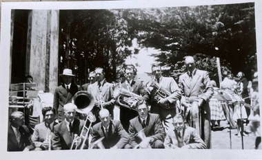
Photograph, Phillip island Band c. 1950-1960
HistoricalBlack and white photograph of male band members holding instruments. Also several music stands. Members of the public standing in the background. Large cypress trees in the background.Rear L-R. Bryant West, Obscured?, Unknown, Stan Walton, Alan Cleeland, Peter Forrest. Front L-R. Artie Murdoch?, Unknown, Bill MCLardy, Noel Cleeland, Harry De La Haye, Robert Cleelandphilip island band, music, harry de la haye, artie murdoch, noel cleeland, bryant west, stan walton, alan cleeland, , peter forrest, bill mclardy -
 Ringwood and District Historical Society
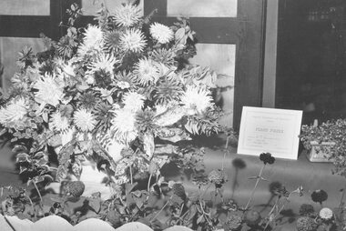
Photograph, Ringwood Horticultural Society- Ringwood Flower Show - 19 March 1959
Black and white photographWritten on backing sheet, "1st Prize - Large floral window display at Goodwins Shoe Store. Mail 19 March 1959. Goodwin had fifth shop in Main Street west of Warrandyte Rd. (Rly. other side of road.) -
 Kew Historical Society Inc
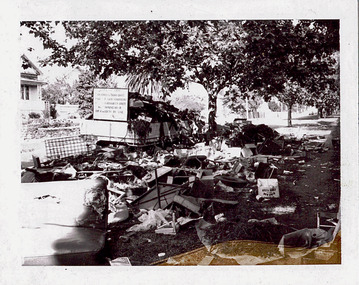
Photograph - Hard rubbish in Parkhill Road
One of eight photographs donated by the City Engineer of the former City of Kew, mostly of hard rubbish clearance during the period 1969-1985.One of a dated series of photographs of core local government services as practised by the City of Kew in the period 1969-1985. Original black and white photographic positive of unburnable hard waste awaiting collection in Parkhill Road, Kew in 1969.Annotation in ink on reverse "17th Nov 1969 / 8.45a.m. / Parkhill Rd West of Adeney Ave". In envelope marked: "Kew City Council / 12 photos / 1969 1979 18980 1985 / Unburnable rubbish units 18/1/80"garbage, hard rubbish, garbage removal, city of kew, local government -- city of kew, household waste, hard waste -
 Bendigo Military Museum
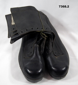
Footwear - BOOTS - GP - ARMY, Department of Defence, Post 1960
Pair of black leather army boots - known as GP's - "General Purpose" with no laces. Top inside boots - cotton label with Department of Defence Size and Fitting information. Rubber sole with imprint of maker's label.Top inside boot - black print on cotton label - "COMFORTWEAR 11/84/ SIZE 12/6 FITTING/ R B" Rubber sole - imprint - maker's label "COMFORTWEAR/ WEST AUST/ BP VULCANISED RUBBER/ SOLE & HEEL"uniform, footwear, boots, army -
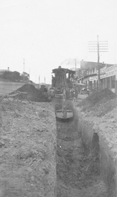 Ringwood and District Historical Society
Photograph, Maroondah Highway Central, Ringwood. Laying water main in Main Street, 1935
Black and white photographImage shows excavator digging trench for water main on Main Road (Maroondah Highway. Towards the west, near the corner of Warrandyte Road. The Ringwood Stationmaster's house is on the left, Bamford's timber yard, Coffee Palace and other shops on right. -
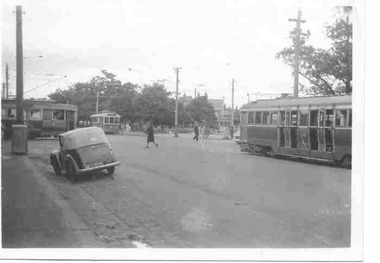 Ballarat Tramway Museum
Photograph - Hospital corner, Music for People day, Wal Jack, 19/02/1950
Photo of four trams at the intersection of Sturt and Drummond streets, on Music for the People day, 19/2/1950. See Inscriptions for details. Trams 13, 12, 34 and 35. Photo by Wal Jack, No. T652. On Kodak print paper. See item 9479 for a photo of tram 34 most likely at the same time. See image i2 for rear of photograph. See image i3 for hi res scan of print. See image i4 for hi res scan of negative No. 863Yields information about tram services on an event day and Hospital corner,Black and white photographOn rear in ink. "Music for the People day 19-2-50" "No. 13 Gardens via Drummond Nth 12 City 34 Mt Pleasant 35 Gardens via Sturt St West" With "W Jack No. "T652" Copyright" stamp.tramways, trams, hospital corner, drummond st, sturt st, festival, tram 13, tram 12, tram 34, tram 35 -
 Ballarat Tramway Museum
Photograph - Colour Photograph/s - set of 25, Austin Brehaut, 7/04/2000 12:00:00 AM
Yields information about various locations in Ballarat in March 2000 for comparison with previous photographs.Set of 25 colour photographs taken by Austin Brehaut on 7 April 2000 showing various locations that Ballarat trams once ran in, for use in a BTM presentation, named "Ballarat Past and Present" at the COTMA 2000 Ballarat Conference. All on Fujicolour Crystal Archive Paper. On rear in blue ink is the date, location and where relevant a reference number to photo locations that the author of the presentation had requested. Letter from Austin, filed with the worksheet for Reg. Item 1772. 1773.1 - Base Hospital, Cnr Drummond St. North and Mair St. .2 - Hospital Corner - Base Hospital Along Drummond St. North .3 - St John of God Hospital, cnr Mair and Drummond St. Nth. .4 - Hospital Corner, looking South East from Base Hospital .5 - Gardens at Loop (Wendouree Parade) .6 - Gardens Loop and Shelter .7 - Shelter at Gardens Loop .8 - Bridge Mall looking west .9 - Lower Victoria St. along Bridge St .10 - Railway crossing, Ballarat Station, with gates open .11 - Victoria St. hill facing west .12 - Railway crossing, Lydiard St. North .13 - Railway crossing, Ballarat Station, with gates closed .14 - Lydiard St. North terminus from cemetery .15 - Lydiard St. North at Macarthur St. .16 - Lydiard St. North at Sturt St facing South East - Post Office on left .17 - Looking north along Lydiard St at Sturt St .18 - Sturt and Lydiard Sts corner from Post Office .19 - Centre plantation Sturt St. looking east .20 - Sturt St. West near Ballarat and Clarendon College .21 - Sturt St. West facing west at Russell St. .22 - Victoria St. terminus .23 - Victoria St. terminus .24 - St Alipius Church, Victoria St. .25 - Junction of tramline and Phoenix foundry railway in Sturt St. at Armstrong St. (transferred from roadway) See Reg item 4645 and 4646 for the 2010 comparisons.See Aboveballarat, hospital corner, gardens loop, railway crossing, lydiard st. north, sturt st, phoenix foundry, armstrong st., victoria st., sturt st. west -
 Melbourne Tram Museum
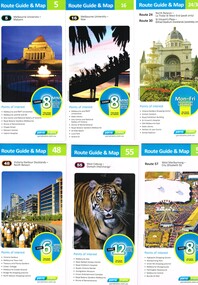
Ephemera - Tram Route Guides, Public Transport Victoria (PTV), "Tram Route Guide", Oct. 2011 to Oct 2012
Set of 23 Tram Route Guides, published during 2011 or 2012. Each comprises a vertical DL folded sheet, full colour for the nominated routes, with Yarra Trams, Myki and TramTracker logos, listing the stops, interchanges with bus and other tram services, ticketing zones, estimated frequencies with adverts for Night tram services, TramTracker and Myki tickets. .1 - Route 5 - Melbourne University to Malvern .2 - Route 16 - Melbourne University to Kew .3 - Route 24 and 30 - North Balwyn - Latrobe St and St Vincent's Plaza - Etihad Stadium .4 - Route 48 - North Balwyn - Victoria Harbour Docklands .5 - Route 55 - West Coburg - Domain Interchange .6 - Route 57 - West Maribyrnong to Flinders St Station .7 - Route 59 - Airport West - City .8 - Route 75 - City - Vermont South .9 - Route 78 and 79 - North Richmond - Prahran or St Kilda Beach .10 - Route 82 - Footscray to Moonee Ponds .11 - Route 96 - East Brunswick - St Kilda Beach .12 - ditto .13 - Route 112/11 - West Preston - St Kilda, West Preston - Victoria Harbour Docklands .14 - Route 70 - Wattle Park - Waterfront City Docklands .15 - Route 86/95 - Bundoora - Waterfront City Docklands and Melbourne Museum - City .16 - Route 1 - East Coburg - South Melbourne Beach .17 - Route 3/3a - Melbourne University to East Malvern .18 - Route 6 - Melbourne University to - Glen Iris .19 - Route 8 - Moreland to Toorak .20 - Route 64 - Melbourne University to East Brighton .21 - Route 67 - Melbourne University to Carnegie .22 - Route 72 - Melbourne University to Camberwell .23 - Route 109 - Box Hill - Port Melbourne and Route 31 - Hoddle St - Victoria Harbour - Docklands .24 - Route 75 - Vermont South - dated 10/2011 See Reg Item 2278 for 2016 versionstrams, tramways, timetables, maps, route 1, route 3/3a, route 5, route 6, route 8, route 11, route 16, route 24, route 30, route 31, route 48, route 55, route 57, route 59, route 64, route 67, route 70, route 72, route 75, route 78, route 79, route 82, route 86, route 95, route 96, route 109, route 112, east coburg, south melbourne, malvern, west maribyrnong, airport west, docklands, north balwyn, west coburg, domain interchange, north richmond, prahran, east brunswick, st kilda, vermont south, footscray, moonee ponds, kew, st vincent's plaza, preston, wattle park, bundoora, museum, south melbourne beach, east coburg, east malvern, glen iris, toorak, moreland, east brighton, carnegie, camberwell, box hill, port melbourne -
 Ballarat Heritage Services
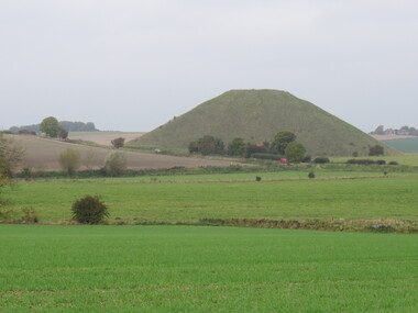
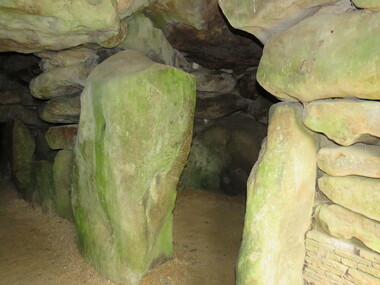
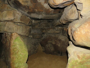
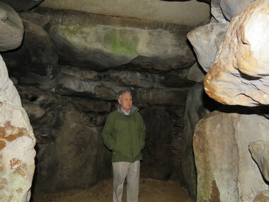
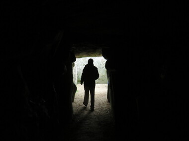
Photograph - Colour, Avebury World Heritage Site, Prehistoric Monuments, England, 2016
Colour photograph of the Silbury Hill, an immense Neolithic man-made mound part of the Avebury World Heritage Site. The Avebury World Heritage Site is a complex of outstanding prehistoric monuments comprising Windmill Hill (Early Neolithic enclosure and Bronze Age burial mounds); Silbury Hill; West Kennet Long Barrow; Avebury Stone Circles and West Kennet Avenue; The Sanctuary (site of stone and timber circles). It is part of National Trust and English Heritage. Visitors may walk to sites.avebury world heritage site, mound, prehistoric monuments, silbury hill, west kennet long barrow, neolithic, world heritage -
 Ballarat Heritage Services
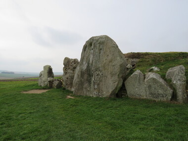
Photograph - Colour, Silbury Hill, Avebury World Heritage Site, Prehistoric Monuments, England, 2016
Colour photograph of the Silbury Hill, an immense Neolithic man-made mound part of the Avebury World Heritage Site. The Avebury World Heritage Site is a complex of outstanding prehistoric monuments comprising Windmill Hill (Early Neolithic enclosure and Bronze Age burial mounds); Silbury Hill; West Kennet Long Barrow; Avebury Stone Circles and West Kennet Avenue; The Sanctuary (site of stone and timber circles). It is part of National Trust and English Heritage. Visitors may walk to sites.Colour photograph of rocks at Avebury World Heritage Site avebury world heritage site, prehistoric monuments, rocks -
 Ballarat Heritage Services
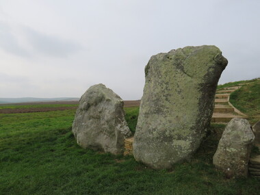
Photograph - Colour, Avebury World Heritage Site, Prehistoric Monuments, England, 2016
Colour photograph of the Silbury Hill, an immense Neolithic man-made mound part of the Avebury World Heritage Site. The Avebury World Heritage Site is a complex of outstanding prehistoric monuments comprising Windmill Hill (Early Neolithic enclosure and Bronze Age burial mounds); Silbury Hill; West Kennet Long Barrow; Avebury Stone Circles and West Kennet Avenue; The Sanctuary (site of stone and timber circles). It is part of National Trust and English Heritage. Visitors may walk to sites.Colour photograph of Avebury World Heritage Stte.avebury world heritage site, prehistoric monuments, rocks -
 Ballarat Heritage Services
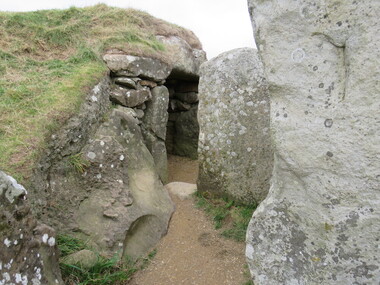
Photograph - Colour, Silbury Hill, Avebury World Heritage Site, Prehistoric Monuments, England, 2016
Colour photograph of the Silbury Hill, an immense Neolithic man-made mound part of the Avebury World Heritage Site. The Avebury World Heritage Site is a complex of outstanding prehistoric monuments comprising Windmill Hill (Early Neolithic enclosure and Bronze Age burial mounds); Silbury Hill; West Kennet Long Barrow; Avebury Stone Circles and West Kennet Avenue; The Sanctuary (site of stone and timber circles). It is part of National Trust and English Heritage. Visitors may walk to sites.Colour photograph of Avebury World Heritage Site. avebury world heritage site, prehistoric monuments, rocks -
 Ballarat Heritage Services
Photograph - Colour, Avebury World Heritage Site, Prehistoric Monuments, England, 2016
Colour photograph of the Silbury Hill, an immense Neolithic man-made mound part of the Avebury World Heritage Site. The Avebury World Heritage Site is a complex of outstanding prehistoric monuments comprising Windmill Hill (Early Neolithic enclosure and Bronze Age burial mounds); Silbury Hill; West Kennet Long Barrow; Avebury Stone Circles and West Kennet Avenue; The Sanctuary (site of stone and timber circles). It is part of National Trust and English Heritage. Visitors may walk to sites.Colour photograph of Avebury World Heritage Site.avebury world heritage site, rocks, prehistoric monuments -
 Ballarat Heritage Services
Photograph - Colour, Wayne Phillipson, Avebury World Heritage Site, Prehistoric Monuments, England, 2016
Colour photograph of the Silbury Hill, an immense Neolithic man-made mound part of the Avebury World Heritage Site. The Avebury World Heritage Site is a complex of outstanding prehistoric monuments comprising Windmill Hill (Early Neolithic enclosure and Bronze Age burial mounds); Silbury Hill; West Kennet Long Barrow; Avebury Stone Circles and West Kennet Avenue; The Sanctuary (site of stone and timber circles). It is part of National Trust and English Heritage. Visitors may walk to sites.Colour photograph of the Avebury World Heritage Site.prehistoric monuments, avebury world heritage site, rocks -
 Ballarat Heritage Services
Photograph - Colour, Wayne Phillipson, Avebury World Heritage Site, Prehistoric Monuments, England, 2016
Colour photograph of the Silbury Hill, an immense Neolithic man-made mound part of the Avebury World Heritage Site. The Avebury World Heritage Site is a complex of outstanding prehistoric monuments comprising Windmill Hill (Early Neolithic enclosure and Bronze Age burial mounds); Silbury Hill; West Kennet Long Barrow; Avebury Stone Circles and West Kennet Avenue; The Sanctuary (site of stone and timber circles). It is part of National Trust and English Heritage. Visitors may walk to sites.Colour photograph of Avebury World Heritage Site. avebury world heritage site, prehistoric monuments, rocks -
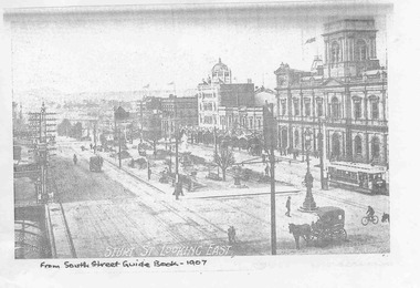 Ballarat Tramway Museum
Document - Photocopies, Royal South Street Society, Royal South Street Society Guide, 2008
Has a strong association with the work of the Royal South Street Society, who published a handbook/guide or manual for their competitions. Used a photograph published at about the same time.Set of 15 photocopies of pages from the Royal South Street Society Guide showing trams in Sturt St Ballarat. .1 - Sturt St Looking East - with an ESCo tram outside the town hall and other horse drawn vehicles - 1907 .2 - Sturt St Looking West - same image as in Reg item 2688 - 1907 .3 - Sturt St Looking East - with many vehicles and people - 1910 and the "Chef" kitch range stove advertisement sold by Middleton and Morris of Sturt St. .4 - Sturt and Lydiard St, with a tram turning from Sturt into Lydiard St, 1910 with the post office in the background - 1910 and an advertisement for Woderine medicine sold by Jas. A. Gear, herbalist. .5 - Sturt St looking West - tram turning from Sturt into Lydiard St, taken from near post office corner - 1911 and a advertisement for Williams the Shoeman. .6 - Sturt St. West - with an ESC0o tram outbound - the only vehicle - 1913. .7 - same photo as .3, with a Monster Military Carnival Advertisement for Nov. 8th - 1913 .8 - Sturt and Lydiard St from next to post office, looking west with two trams, one horse trailer and many people - a busy scene - 1914 .9 - Sebastopol tram No. 21 at Grenville St - 1928 - with the Ballarat Gas Company Show rooms in the background, the Sturt St shelter. The tram has a Suttons Organs roof advertisement. .10 - View of Sturt Street, showing City Hall Buildings, with an ESCo Sebastopol type tramcar crossing the street, taken from the post office stops. - 1928 - Advertisements for G. Ludbrook Furnishing Undertaker (Motor Service and Horse drawn vehicles) and R. Young Grocer. .11 - Sturt St looking West, looking west, with a Sebastopol type tram at Grenville St and the big shelter removed. Has many buildings and many people in the background - 1928. .12 - same photo as for .10 and Clarendon Presbyterian Ladies Collection, Ballarat photograph - 1929. .13 - Advertisement for Ballarat Tramways - cars for Coliseum, fare box, route numbers and route colour scheme - 1929. .14 - as for above, no date, but opposite is the is an item for the Mouth Organ Band Contest, "A" Grade - c1933, notes the Coburg Tramway Athletic Club Harmonica Band and the Malvern Tramways Harmonica band amongst the contestants. .15 - same as .9, with a advertisement for the Melbourne Coffee Palace - Bourke St. Photocopies made by Neville Hasket for the BTM 10/2008. See also Reg item 675 for alternative source details.Handwritten note on photocopiestrams, tramways, ballarat, sturt st., royal south street society, lydiard st, town hall, post office, esco -
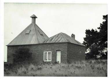 Phillip Island and District Historical Society Inc.
Photograph, Richardson's chicory kiln 1077-01
In 1878, the first chicory kiln was built by Mr. John and Solomon West, in Thompson Avenue, Cowes, near the Esplanade and the second kiln was built in 1880 by Mr Joseph Richardson.HistoricalLarge black & white photo of a brick chicory kiln with a metal roof,door and window. In a paddock with large trees nearby.2nd chicory kiln on Phillip Island, now turned into a holiday house.chicory, chicory kilns, joseph richardson, -
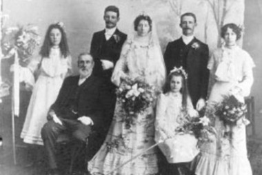 Greensborough Historical Society
Photograph - Digital Image, Gilding group 1, 1893c
Photograph of wedding group from Gilding family. The Gilding family lived in Greensborough. They operated a bootmaker's shop located on the west side of Main Street, north of the rail line.Digital copy of black and white photograph.gilding family, gilding -
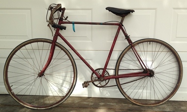 Geelong Cycling Club
Road Cycle, 1920
This is a Bluebird road cycle made in 1920 by Alan Lowndes from Modewarre. It was purchased by Ray Kinleyside (secretary of the Geelong West Amateur Cycling Club) after WWi in the 1920s.An example of road cycles commonly used in the 1920s.Unrestored road cycle painted red. It is a single brake, single speed bicycle. alan lowndes; ray kinleyside; bluebird road cycle; geelong west amateur cycling club; geelong cycling club; road cycle; -
 Tatura Irrigation & Wartime Camps Museum
Booklet, Shepparton Past and Present, 1975
Contributed from writings of Cr. W S James (History of Shepparton), Raymond West, MBE, former town Clerk of Shepparton "Those Were the Days and Streets of Shepparton"Cream cover, sketches of Shepparton Post office 1882 and 1975 on front. Photograph of 100 year memorial on back cover. 48 pages.shepparton history, cr w s james, raymond west mbe, shepparton council clerk -
 Heidelberg Golf Club
Book, Melbourne Parks and Waterways, Lower Plenty River concept plan: Maroondah Pipe Track to Yarra River, 1994
Lower Plenty River concept plan: Maroondah Pipe Track to Yarra River. Includes suggestion of Plenty River Trail along the west boundary of the Heidelberg Golf Club.66 p., illus., colour map. Also, Draft copy of document.plenty river trail, lower plenty river, heidelberg golf club, mmbw, melbourne parks and waterways -
Clunes Museum
Painting, Richard Ford, 1956
Richard Ford was a local artist heavily involved in the local community, famous for the theatrical backdrop in the Clunes Town Hall as well as the WWI mural on the west wall of the same building.This painting is an example of the type of work that was produced by a Clunes local artist. This painting was a gift from Richard Ford to the Late Reg Kinnersly who was a pupil in Richard Ford's "Sloyd" , arts and craft style classFramed painting "Still Life" of vase and flowers dated 1956Signed by artist Richard Fordrichard ford, artist, mural, wwi -
 Melbourne Tram Museum
Ephemera - Route 58, "Tram Network upgrade", June 2023
Provides details of track replacement work on route 58 in Melville Road, Pascoe Vale south / Brunswick West between 18/8/2023 to 18/9/2023.Yields information about track replacement work in Melville Road.Five A4 page document - printed.tramways, trackwork, melville road, brunswick west, pascoe vale south, route 58 -
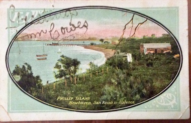 Phillip Island and District Historical Society Inc.
Photograph - Post Card, Newhaven postcard, About 1910
Postcard from Lizzie to Mrs Harry West " Moncrieff Bank", Cowes. 'Wishing you all A happy and Prosperous New Year 1910. Your loving cousin, Lizzie'Coloured postcard showing coastline, bay, jetty and buildings at Newhaven. Looking towards San RemoPhillip Island Newhaven, San Remo in the distance. Greetings from Cowes written in gold glitternewhaven, jetty, newhaven, photographs, postcards, moncrieff bank, harry west -
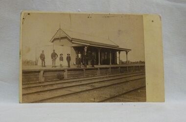 Wycheproof & District Historical Society Inc.
Sepia photo, Photographer unknown, Historic Wycheproof Railway Station, 1904 (estimated)
This railway station building was erected in 1887 and closed in 1990. Now a new chapter begins with a newly restored station building amd platform that re-opened in October 2010 to be used by the Wycheproof Community.The Wycheproof Railway station constructed by Hossack & Brown in 1887 is Heritage listed and is on the Government Buildings Register. This photo is one of only a few available of the early days of the Station.The complex is historically significant at a State level AHC A.4. The Railway station contains significant detailing such as in the turned timber posts and overall composition. This early photo of Wycheproof railway station, shows a construction of timber with corrugated iron clad roof,in c.1904. Features of the design are the timber verandah posts with decorative elements which include chamfers and supporting diagonal timber brackets. The gabled roof has finials on the east and west ends. Seven people pose on the platform,the staff in uniform of the times.Nilregister, , railways, wycheproof, historic buildings, 1900s -
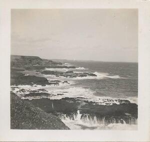 Phillip Island and District Historical Society Inc.
Photographs, 11/1946
Part of a collection of photographs donated by Julie Barnett. Photographs taken by Julie's In-laws whilst on their honeymoon in November 1946. The practice of handling penguins by the public is no longer accepted.229-44. Black & White photograph of the coastline looking from The Nobbies toward Cape Woolamai. 229-45. Black & White photograph of Ken West with a penguin at The Nobbies. 229-46. Black & White photograph of Dorothy Dallimore with a penguin at the Summerland Rookeries. 229-47 to 229-49. Black & White photographs of the breakers at The Nobbies, Phillip Island.wildlife - penguins, penguins, the nobbies phillip island, phillip island coastline, coastline phillip island, ken west, dorothy dallimore, julie barnett -
Glenelg Shire Council Cultural Collection
Photograph - Copy of Photograph - Store of James Robertson, 1859
Vern Mc Callum CollectionDigital copy of monochrome photo taken in Portland in 1859. Store of James Robertson west side of Percy street. Between Henty and Tyers streets. Double storey tin building, with curved roof. Horse and cart standing in front. Two single storey bluestone buildings on left store, several people and large dog standing on the foot path. -
 Ringwood and District Historical Society
Flyer, Land Sale Advertisement and auction notice - Range View Estate, Ringwood, Victoria - 1920
Advertisement for sale of 150 residential allotments with terms of sale, summary of local features and services, and map showing location and layout of subdivision within the boundary of Mitcham to the west of Ringwood, Victoria. Copy of newspaper advertisement (The Herald, Melbourne, Wednesday 3 March, 1920) refers to public auction date for Range View Estate Ringwood - Saturday, 27th March, 1920.Subdivision includes Deep Creek Road, Range View Grove, Warnes Road, Tarrangower Avenue, Prince Edward Avenue, James Avenue, and White Horse Road, Mitcham. Agents - Phillips & Nicholson, 281 Collins Street, Melbourne, Telephone Central 10907.