Showing 27536 items
matching yarra-river
-
 Kew Historical Society Inc
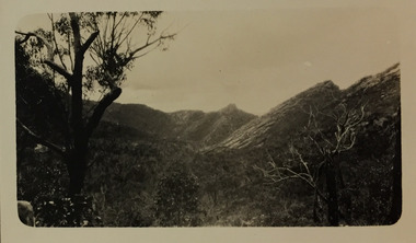
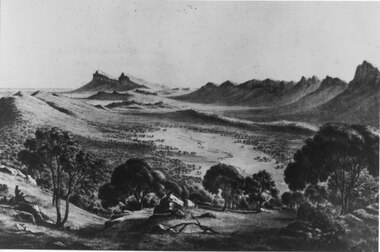
Photograph - Grampians, 1924
Henry Beater Christian (1886-1962) , was a descendant of one of the earliest settler families in Kew. Employed at the Kew Asylum as a 'public servant', he was a skilled amateur photographer, photographing numerous scenes in Kew and on his travels around Victoria. The majority of his photographs date from 1916 to 1929. His finest photographs are housed in two photograph albums. Digital copy of a photograph from page 15 of the 47-page photograph album containing 261 gelatinous silver images, loaned by Diane Washfold with permission given to digitise and hold a copy in our collection. The first and last pages in the album document the Yarra River at Studley Park and at Kew. The remainder of the album includes photographs of walking and car tours in rural Victoria including 'wilderness' areas in the Grampians, Gippsland and the High Country. Six album pages document a camping trip by Henry Christian to the Grampians in September 1924. The photos include pictures of lookouts, and natural features including rock faces and waterfalls, as well as his camp site. This photo is a long distance view of the mountains with trees framing the picture in the foreground. "Grampians"henry beater christian (1886-1962), landscape photography, christian-washfold collection, photograph albums, grampians, mt victory, gariwerd -
 Eltham District Historical Society Inc
Photograph - Aerial Photograph, Landata, Lower Plenty, Vic, Apr. 1963
Centred on present day Old Eltham Road near Araluen Centre, Lower Plenty bounded by Cromwell Street to north, Yarra River to south, Main Road at Mount Pleasant Road to east and Panorama Avenue to west. Historic Aerial Imagery Source: Landata.vic.gov.au Aerial Photo Details: Project No :486 Project : MELBOURNE (1963) PROJECT Run : 7 Frame : 231 Date : 04/1963 Film Type : B/W Camera : RC8 Flying Height : 5100 Scale : 9600 Film Number : 1805 GDA2020 : 37°44'03"S, 145°07'56"E MGA2020 : 335420, 5822027 (55) Melways : 21 F10 (ed. 42)aerial photo, neil webster collection, 1963-04, araluen, cromwell street, eltham, lower plenty, main road, melway 21f10, mount pleasant road, old eltham road, panorama avenue, yarra river -
 Eltham District Historical Society Inc
Photograph - Aerial Photograph, Landata, Eltham, Vic, Apr. 1963
Centred on present day Eltham Lower Park bounded by Brougham Street to north, Yarra River and Fitzsimons Lane Bridge to south, Main Road at Kent Hughes Road to east and Bolton Street to west. Historic Aerial Imagery Source: Landata.vic.gov.au Aerial Photo Details: Project No :486 Project : MELBOURNE (1963) PROJECT Run : 7 Frame : 232 Date : 04/1963 Film Type : B/W Camera : RC8 Flying Height : 5100 Scale : 9600 Film Number : 1805 GDA2020 : 37°44'03"S, 145°08'33"E MGA2020 : 336329, 5822040 (55) Melways : 21 H10 (ed. 42)aerial photo, neil webster collection, 1963-04, bolton steet, brougham steet, eltham, eltham lower park, fitzsimons lane bridge, kent hughes road, melway 21h10, yarra river -
 Mission to Seafarers Victoria
Film - VHS, Flying Angels, 1995
In the Annual Report 1995: " During the year, a group of young people sponsored by the L.E.A.P. organisations, spent some weeks at the 717 Flinders Street, designing and making a video about the work and life of the Mission." The documentary filmed in VHS, mixes interviews, images from the MTSV collection and shooting of the port, the mission under renovation. Intro: Yarra River Images of the Sherlock Holmes Hotel. Archbishop Rodney Oliver, son of Reverend Padre Oliver, and Chairman of the State Council talks about the history of the Mission. John Phillips, caretaker Joan Leslie, volunteer The film has been transferred onto DVD, USB key and saved on digital form.john rodney oliver, dora simpson nee walker, john phillips, caretaker, joan leslie -
 Melbourne Tram Museum
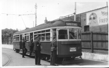
Photograph - Set of 5 Black & White - First AETA tour, 15-2-1947
Set of five photographs of the first Australian Electric Traction Association (AETA) tram tour of Melbourne on 15/2/1947. See page 8 of the March 1947 issue of "Tram Tracks" for details of the tour and the MMTB Crew. 1 - SW6 881 about to leave Glen Huntly Depot 2 - Crossing Balaclava Junction 3 - Crossing the Kooyong railway level crossing in Glenferrie Road - has the railway signal box and gates in view. 4 - Turning into Riversdale Road from Glenferrie Road with the Stotts Business College building in the background. 5 - Just to the east of Yarra River Bridge in Swan Street with the Burnley Gardens on the right.Yields information about the first AETA tram tour in 1947Set of 5 Black and white photograph on paper. Two copies of each held.Each one of the set has a photographers file stamp on the rear, but no details filled in.trams, tramways, aeta, tram tours, tram 881, sw6 class, glen huntly, kooyong level crossing, glenferrie road, riversdale road, burnley, hawthorn, balaclava junction, glen huntly depot, hawthorn road, swan st -
 Federation University Historical Collection
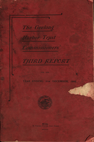
Book - Annual Report, H Thacker, The Geelong Harbor Trust Commissioners' Third Report for the year ending 31st December 1908, 1909
In 1908 the Geelong Harbor Trust commissioners were George Frederick Holden, Edward Harewood Lascelles and James Hill. The officers were Walter S. Crowle (Secretary), A.C. McKenzie (Engineer), Captain G.A. Molland (Harbor Master), E.R. Hitch, (Assistant Harbor Master, Portarlington.)Red soft covered foolscap report of 101 pages. Includes two photographic reproductions of teh New Cargo Shed on Yarra Pier, and Twin S.S. "G.F. Holden" (formerly the 'Pelican' (built in 1898 by Fleming & Ferguson, Paisley, England, for the Western Australian Government).Seal of the Geelong Harbour Trust Commissionersgeelong, harbour trust, commissioners, report, finance, properties, dredging, portarlington, barwon heads, ocean grove, shipping, engineer's report, assets, liabilities, harbor trust, geelong harbor trust, grain shipping berthage, corio quay, cool stores, dock accomodation, floating plant, hopetoun channel, moorabool pier shed, sparrovale irrigation farm, thomas gibson-carmichael, yarra pier cargo -
 Orbost & District Historical Society
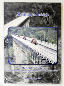
book, McKillops Bridge, 2014
This book was purchased new by Orbost & District Historical Society. Written by Buchan historian, Rhonda Coates, the book was commissioned by Tubbut Neighbourhood House following a commemoration event in 2002 when many people gathered for a special day organised by Sister Helen Barnes and the Tubbut community. (ref. Bombala Times)This book is a useful research item.A paper back book, titled McKillops Bridge, written by Rhonda Coates. On the front cover is a photograph tractors crossing the bridge during the Great Snowy River Tractor Stampede ( The Snowy River Tractor Strampede, a 560-kilometre journey, is organised by the Bega and District Historical Machinery Club every January - the first being held in 2009.) this photograph is inset over an earlier phpotograph by Howard Bulmer c 1936. The book contains the history of the bridge, photographs of the bridge and times before its construction.On front fly-Orbost &District Historical Society Incmckillops-bridge -
 Bendigo Historical Society Inc.
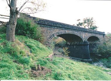
Photograph - BENDIGO HISTORICAL SOCIETY COLLECTION: REDESDALE BRIDGE
Colour photograph of the Redesdale bridge over the Campaspe River at Redesdale. The Redesdale Bridge is one of the oldest iron lattice-truss bridges in Victoria, Australia. The Redesdale Bridge is a wrought iron and timber structure with bluestone abutments, located over the Campaspe River near the town of Redesdale. Image taken from Redesdale side of bridge showing two lane design. Plaque on bridge in centre of divided road reads ' Shire of Metcalfe'. Photo taken during a BHS tour, possibly 1990's.bridge -
Bendigo Historical Society Inc.
Document - STATE RIVERS AND WATER SUPPLY COMMISSION : COLIBAN SYSTEM CRITICAL STORAGE CURVES
State Rivers and Water Supply Commission of Victoria. Coliban System. Construction of Lake Eppalock. Chart titled 'Coliban System Critical Storage Curves'. Includes table headed ' Estimated requirements for various degrees of restricted consumption' related to the demand on the Coliban River. Figures on storages of Upper Coliban, Lauriston, Malmsbury, Barkers Creek, and Spring Gully. There are pencilled notations added. The information appears to be for the years 1957/58/59. The item referred to in this description HAS NOT BEEN SCANNED.state infrastructure, water supply, coliban system, state rivers and water supply commission of victoria. coliban system. lake eppalock. -
Bendigo Historical Society Inc.
Map - REDESDALE : COUNTY OF BENDIGO, 25 -10-77
Map. Redesdale, County of Bendigo, County of Dalhousie, County Of Talbot, Lyell, Kimbolton, Langwornor, Spring Plains, Glenhope, Emberton, Metcalfe, Hawkestone, River Coliban, Campaspe River, Back Creek. Photo-Lithographed at the Department of Lands and Survey, Melbourne by J. Noune, 25-10-77. Compared with original plans 12-11-78 M. Kemp. J.C.Kelsh, Draughtsman April 1876. Examined by E. Downward, 5-6-77. (number 121 in map cupboard 1)J. Nounemap, bendigo, redesdale -
 Victorian Aboriginal Corporation for Languages
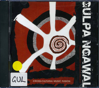
Audio CD, Laura Brearley et al, Gulpa ngawal : Indigenous deep listening, 2009
Introduction: In the Ngungikurungkurr language of the Daly River in the Northern Territory, the word for "Deep Listening" is 'Dadirri' (Ungunmurr, 2009) and in the Yorta Yorta language of the Murray River in Victoria, it is 'Gulpa Ngawal'. The closest we can get to describing it in English is deep and respectful listening which builds community. Deep listening draws on many senses beyond what is simply heard. It can take place in silence. Deep listening can be applied as a way of being together, as a research methodology and as a way of making a difference.CDsilcar, rmit, monash, koorie heritage trust, yorta yorta, taungurung, gunnai, gippsland, gunditjmara, richard frankland, deep listening, woolum bellum, education, art, music, indigenous research, sista girl productions -
 Victorian Aboriginal Corporation for Languages
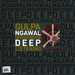
Book, Laura Brearley et al, Gulpa ngawal : Indigenous deep listening, 2010
Introduction: In the Ngungikurungkurr language of the Daly River in the Northern Territory, the word for "Deep Listening" is 'Dadirri' (Ungunmurr, 2009) and in the Yorta Yorta language of the Murray River in Victoria, it is 'Gulpa Ngawal'. The closest we can get to describing it in English is deep and respectful listening which builds community. Deep listening draws on many senses beyond what is simply heard. It can take place in silence. Deep listening can be applied as a way of being together, as a research methodology and as a way of making a difference.colour illustrations, colour photographsyorta yorta, taungurung, gunnai, gippsland, gunditjmara, richard frankland, deep listening, woolum bellum, education, art, music, indigenous research, sista girl productions -
 Melbourne Tram Museum
Photograph - Set of 3 Black & White Photograph/s, Melbourne & Metropolitan Tramways Board (MMTB), 1954
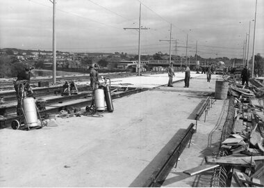
Series of 3 black and white photographs of:- .1 - construction of the trackwork for the new Maribyrnong River Bridge, has the temporary track on the left hand side of the photograph. Has the Express Freight Transport building in the background. .2 - as above, appears that the track on the northern side is almost completed. An Inspector is standing watching the work. This work was completed mid 1967. .3 - construction of trackwork possibly the curve from Gordon St to run alongside now River St. This work was undertaken during 1954.Some photos have pencil marks on rear.trams, tramways, trackwork, rails, track materials, track repairs, sleepers, equipment, maribyrnong river bridge, bridges, gordon st, river st, footscray -
 Port Fairy Historical Society Museum and Archives
Photograph - newspaper photograph
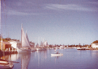
Moyne river moyne river, boats, sails -
 Orbost & District Historical Society
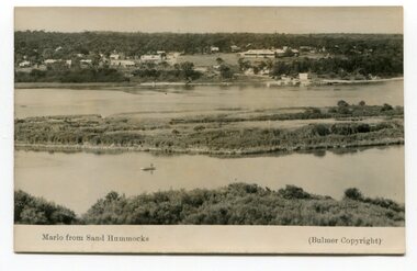
black and white photograph, Howard D. Bulmer, 1936?
Marlo was once a very busy port. Goods needed by the early settlers were carted by sea-going vessels to Marlo. At the Marlo wharf goods were unloaded from the large vessels onto barges and towed by paddle steamers to Orbost. (information - In Times Gone By - Deborah Hall)The Marlo Hotel, perched on the hill overlooking the estuaries and the entrance is a significant building in Marlo. Established in 1886, it has been operating for over 120 yearsA black / white photograph of the Marlo landscape. In the background is the Marlo Hotel. Appears to have been taken from Corringle looking out over ocean and Snowy River. The Marlo Hotel can be seen on the right.Thon front - "Marlo from Sand Hummock"; "Bulmer copyright"marlo-landscape marlo-hotel-township -
 Federation University Historical Collection
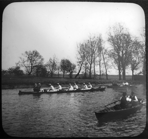
Photograph - Glass Plate, Henry Sutton, Rowing by Henry Sutton, 1892
Henry Sutton was born in Ballarat into the musical Sutton Family. He is known as an important Australian inventor. Photograph of a team of six rowing, and two other row boats. The race took place during the Ally Sloper's Day Regatta in 1892. The regatta took place on the River Lea near Hackney, London. henry sutton, glass plates, photography, rowing, rowboats, ally sloper's day regatta, henley on the lea -
Glenelg Shire Council Cultural Collection
Souvenir - Cloth Shoulder Patch, Nelson, Victoria Patch, n.d
Coloured rectangular, vinyl shoulder patch, view of Glenelg River and boat houses at Nelson. 'A Great Place to Relax" - in yellow, 'NELSON VICTORIA' in white. Edges whipped in black, reverse side white felt.glenelg shire, nelson, souvenir -
 Mission to Seafarers Victoria
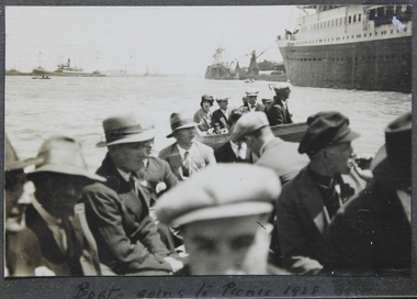
Photograph - Photograph, Black and white, Boats going to picnic, 1928
Picnic Picnics were one the events the Mission with the Ladies Harbour Light Guild would organise on regular basis. This was an opportunity for the sailors to enjoy some time off on the land, a time to play games and sports.Black and white photograph depicting sailors wearing suits and hats seated in two motor boats on the river. In the background on the right is the ship they might have just left to go to a picnic. On loose page 14Below on the album page is written: Boats going to picnic 1928.picnic, lhlg, sailors, seamen, yarra river, ship, melbourne, 1928, fan album, john reginald weller (1880-1969) -
 Halls Gap & Grampians Historical Society
Photograph - B/W
This is a photo of a lithograph by Eugene von Guerard (1811-1901), "Source of the Wannon", circa 1866-1868. The peaks in the distance are Mr Abrupt and Signal Peak.This is a photo of a lithograph. It is a stylised view of a mountain range with sharp rocky peaks with a valley through the centre. A river meanders down the valley. There are eucalyptus trees in the foreground and two figures can be seen in the left foreground.Photo printers stamp in back is "H/GAP0007 NNNAA"painting, landscape -
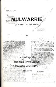 Bendigo Historical Society Inc.
Book - STRAUCH COLLECTION - MULWARRIE (A TOWN ON THE RIVER) A HISTORY OF BRIDGEWATER-ON-LODDON TOWNSHIP AND DISTRICT 1836-1971, 1971
Mulwarrie (A Town on the River) A History of Bridgewater-on-Loddon Township and District 1836 - 1971 Published by back to Bridgewater committee 80 pages with black and white photographs. Printed by Jim Lowden printing Kilmore 3601.victoria, history, bridgewater-on-loddon -
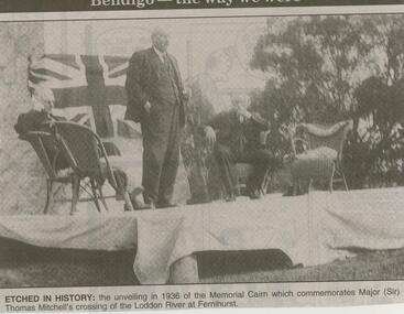 Bendigo Historical Society Inc.
Newspaper - JENNY FOLEY COLLECTION: ETCHED IN HISTORY
Bendigo Advertiser ''The way we were'' from 2001. Etched in history: the unveiling in 1936 of the Memorial Cairn which commemorates Major (Sir) Thomas Mitchell's crossing of the Loddon River at Fernihurst. The clip is in a folder.newspaper, bendigo advertiser, the way we were -
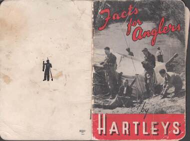 Bendigo Historical Society Inc.
Book - RAILWAYS COLLECTION: FACTS FOR ANGLERS BY HARTLEYS
RAILWAYS COLLECTION - small black and white book with red lettering. Book - Facts For Anglers by Hartleys - Black and white photo of anglers camped by a river - 48 pages including pictures some loose pages.Hartleysbook -
Tatura Irrigation & Wartime Camps Museum
Book, Department of Agriculture Victoria, Institute for Sustainable Agriculture, 1993
Investigation of salinity problems by staff at Tatura, Kyabram, Shepparton, and Cobram Institutes.Department of Agriculture photos on front. Saline waterlogged land near Shepparton. Measuring white clover growth. Salinity management plans for research. Farm planning blueprint. Satellite image of plains and Lodden river.salinity, department of agriculture, kyabram, tatura, shepparton, cobram -
 Tatura Irrigation & Wartime Camps Museum
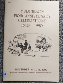
Booklet, Murchison 150th Anniversary Celebrations 1840-1990, 1990
Printed as a programme and historical record of the town of Murchison at 150th celebrations in 1990. Cream coloured soft cover, brown printing, aboriginal camp and bullock team and wagon on front cover and a picture of crossing the river in 1860 on the back cover. 4 black and white photographs. 16 pages. Murchison 150th Anniversary 1840 -1990murchison, books, history, 150th celebrations of murchison -
 Hume City Civic Collection
Photograph, late 1980s
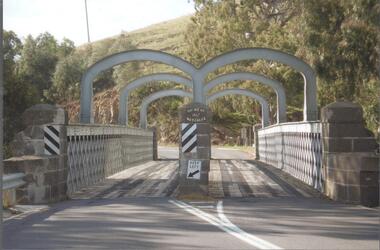
The road bridge over Jackson's Creek in Sunbury was built in 1870 and was in use until a wider bridge was built when Sunbury Road was rebuilt in the early 1970s.A coloured photograph taken from the NE side of the river bank of a complete view of the bluestone bridge at Macedon Street. The two eliptical arches and the protruding pylon as well as the underside of the bluestone span are clearly visible.transport, roads and bridges, jacksons creek, harris, thomas lascelles, george evans collection -
Lakes Entrance Regional Historical Society (operating as Lakes Entrance History Centre & Museum)
Photograph, 1940 c
Also a black and white photograph of gravel road in Buchan Caves reserve 05439.1 14 X 7 CMBlack and white photograph of Miss Dora Bradley, Miss Bailey,Miss Rivers, Miss Carlyle and Miss Turner teachers from St Annes Girls School on visit to Buchan Caves Buchan Victoriatourism, parks -
Lakes Entrance Regional Historical Society (operating as Lakes Entrance History Centre & Museum)
Book, Fairweather, Keith Mc D, Brajerack - Mining at Omeo and Glen Wills
A Description of the mining industry in the northern part of of the Shire of Omeo, Victoria,dealing with the settlements of Omeo, Glen Wills, Sunnyside, Saltpetre Creek and Wombat, also Cobungra River and Newrush Creek. Aboriginal identities IllustratedRuth Clarkaboriginals, mines and mining, land settlement -
Lakes Entrance Regional Historical Society (operating as Lakes Entrance History Centre & Museum)
Book, Fish Marie and Holding Marion, Paddle Steamers of the Gippsland Lakes and Rivers, 1994
Very brief stories of the eighteen known paddle steamers which plied the Gippsland Lakes, in the era the waterways of the lakes and rivers were the major means of communications and transport for the region. Illustrated with sketches and facsimiles of docships and shipping, waterways -
Lakes Entrance Regional Historical Society (operating as Lakes Entrance History Centre & Museum)
Book, Hawkins Richard, Maritime Incidents on the Gippsland Lakes and Adjaent Lakes, 1989
A comprehensive boating guide to the Gippsland Lakes, Lake Tyers, Marlo, Bemm River, Sydenham, Tamboon and Mallacoota Inlets, includes short list of bird life and fish species, and description of towns bordering the waterways.waterways, boats and boating -
 Lakes Entrance Regional Historical Society (operating as Lakes Entrance History Centre & Museum)
Photograph, 1900 c
Black and white photograph showing tug boat Tarra and barge Tambo unloading wool from Ensay, via Mossiface, at wharf on Mitchell River. Wharf, sheds and butter factory in background. Bairnsdale Victoriaships and shipping, waterways