Showing 5882 items
matching residential
-
 Greensborough Historical Society
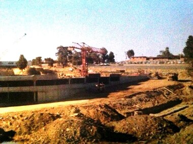
Photograph - Digital image, Building of Greensborough Plaza, 1978_
Building of Greensborough Plaza was done in the late 1970's and opened in 1978. It occupied land previously used largely for residential and grazing purposes. This project saw the transformation of a sleepy outer suburb into the activity centre it now is. Digital copy of colour photograph.greensborough plaza, building projects -
 Greensborough Historical Society
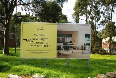
Photograph - Digital Image, Marilyn Smith, Polaris sign at Larundel, 05/09/2017
This photograph shows the Polaris sign at the old Larundel Hospital site. Some buildings on this site are heritage listed on the Victorian Heritage Database. The Polaris development has utilised the open space at Larundel for residential and commercial use.Digital copy of colour photographlarundel hospital, polaris -
 Ringwood and District Historical Society
Document, Short history of Nunawading, c 1950
This report covers some of the eastern suburbs of Melbourne from 1834 to 1890 (approx). The early settlement of Nunawading, agricultural development, industries, residential development, institutions and hotels. Place names , churches and schools are also included4 pages of typed notes of the short history of Nunawading between 1834 and 1890 (approx) +Additional Keywords: Holland, Clisby, Williams, Riles, Polak,Schwerkolt, Smith, Rooks, Boyle, Sergeant, Matters, Ainger, Slater -
 Phillip Island Conservation Society Inc.
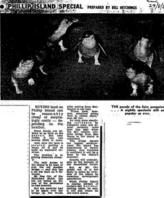
Work on paper - Photocopy of newspaper cutting, Melbourne Sun newspaper, "PHILLIP ISLAND SPECIAL PREPARED BY BILL HITCHINGS", 29.08.1969
This article by journalist Bill Hitchings describes the state of the land market and cost of transporting building materials, Phillip Island, late 1960s. At that stage a number of outlying residential estates had been created, especially on Phillip Island South Coast and at Cowes West. While blocks of land on the outlier estates were very cheap and poorly serviced, the Cowes blocks were selling at $3000 per residential block. Hitchings quotes the owner of the Hollydene motel, Reg Orr, as saying that when the new bridge opens shortly he did not expect it to create a rush of visitors or residents.Bill Hitching was a well-known Melbourne journalist. This article gives an idea of land values on Phillip Island in the late 1960s, the fact that business owners were prepared to upgrade and expand their businesses to cater for extra potential demand on accommodation, and the strong identification of Phillip Island with the Phillip Island Penguin Parade in the minds of the general public in Melbourne. The significance of the new Phillip Island bridge to Phillip Islanders and visitors, and the cost of the bridge, are also outlined. Reg Orr was highly active in the business community of that era on Phillip Island. The Hollydene motel was a well-known Phillip Island accommodation venue.T-shaped article cutting with large image at top of article, dark due to poor photcopy. Double collumn text under photo clearly readable. Black and white.Sun/29/8/6 (?) Probably: Melbourne Sun newspaper, 29 August, 1969phillip island, phillip island tourism, development, hollydene motel, reg orr, phillip island penguin parade, land values, phillip island first bridge, phillip island 2nd bridge, transportation costs -
 Greensborough Historical Society
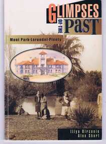
Book, Glimpses of the past: Mont Park, Larundel, Plenty. By Iliya Bircanin and Alex Short, 1909o
The psychiatric hospitals at Mont Park, Larundel and Plenty closed in the late 1970s and this book gives a brief history of the group of hospitals. The area has since been redeveloped into a residential area, although some of the original buildings remain.This book gives an outline of life within the hospital precinct.64 pages, illus. (some col.). Cover includes sepia photo 'Pond at Farm Worker's Block circa 1927'.mont park hospital, larundel hospital, plenty hospital, iliya bircanin, alex short, nemps, north eastern metropolitan psychiatric services -
 Greensborough Historical Society
Photograph - Digital Image, Marilyn Smith, Birds at Larundel, 05/09/2017
This photograph shows some wildlife (birds) at the old Larundel Hospital site. Some buildings on this site are heritage listed on the Victorian Heritage Database. The Polaris development has utilised the open space at Larundel for residential and commercial use.Digital copy of colour photographlarundel hospital, polaris, birds -
 Eltham District Historical Society Inc
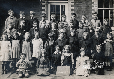
Photograph, Grade IIB, Yarra Park State School No.1406, c.1928, 1928c
Yarra Park State School No.1406 (also known as Yarra Mews) was located at 1055 Punt Road, East Melbourne. It was built 1874 - 1877. Its current use is residential appartments. It is listed in the Victorian Heritage Database. yarra park state school no. 1406, schools, yarra park, yarra mews, class photo, east melbourne, state school no. 1406 -
 Eltham District Historical Society Inc
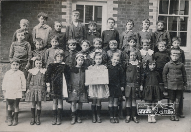
Photograph, Grade IIC, Yarra Park State School No.1406, c.1928, 1928c
Yarra Park State School No.1406 (also known as Yarra Mews) was located at 1055 Punt Road, East Melbourne. It was built 1874 - 1877. Its current use is residential appartments. It is listed in the Victorian Heritage Database. yarra park state school no. 1406, schools, yarra park, yarra mews, class photo, east melbourne, state school no. 1406 -
 Eltham District Historical Society Inc
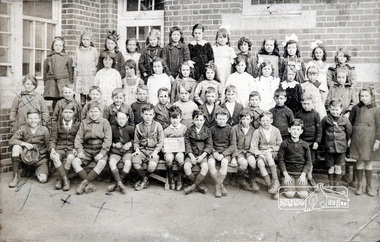
Photograph, Grade 3B, Yarra Park State School No.1406, c.1928, 1928c
Yarra Park State School No.1406 (also known as Yarra Mews) was located at 1055 Punt Road, East Melbourne. It was built 1874 - 1877. Its current use is residential appartments. It is listed in the Victorian Heritage Database. yarra park state school no. 1406, schools, yarra park, yarra mews, class photo, east melbourne, state school no. 1406 -
 Port Melbourne Historical & Preservation Society
Document - Reports, Department of Infrastructure, C5 amendment to Port Phillip Planning Scheme, Department of Infrastructure, 1999
The C5 Amendment aimed to create a framework for built form and development controls in the Port Melbourne Mixed Use Area undergoing conversion to residential development. Heritage overlays to protect heritage areas were also under review.Developer submissions to an independent Panel reviewing the C5 amendment to the Port Phillip Planning Scheme, 1999 Report from Department of Infrastructuretown planning, built environment - civic, heritage, becton, fox hay timber and hardware pty ltd -
Port Melbourne Historical & Preservation Society
Document - Reports, Department of Infrastructure to panel reviewing C5 amendment to Port Phillip Planning Scheme, Graham Deacons et al, 1999
The C5 Amendment aimed to create a framework for built form and development controls in the Port Melbourne Mixed Use Area undergoing conversion to residential development. Heritage overlays to protect heritage areas were also under review.Developer submissions to an independent Panel reviewing the C5 amendment to the Port Phillip Planning Scheme, 1999 Report from Deacons, Graham and James for Bectontown planning, built environment - civic, heritage, becton, fox hay timber and hardware pty ltd -
Port Melbourne Historical & Preservation Society
Document - Reports, Deacons, Graham and James for Becton and others to panel reviewing C5 amendment to Port Phillip Planning Scheme, Graham Deacons et al, 1999
The C5 Amendment aimed to create a framework for built form and development controls in the Port Melbourne Mixed Use Area undergoing conversion to residential development. Heritage overlays to protect heritage areas were also under review.Developer submissions to an independent Panel reviewing the C5 amendment to the Port Phillip Planning Scheme, 1999 Report from Deacons, Graham and James for Becton and otherstown planning, built environment - civic, heritage, becton, fox hay timber and hardware pty ltd -
Port Melbourne Historical & Preservation Society
Document - Reports, Deacons, Graham and James for Fox Hay and Co to panel reviewing C5 amendment to Port Phillip Planning Scheme, Graham Deacons et al, 1999
The C5 Amendment aimed to create a framework for built form and development controls in the Port Melbourne Mixed Use Area undergoing conversion to residential development. Heritage overlays to protect heritage areas were also under review.Developer submissions to an independent Panel reviewing the C5 amendment to the Port Phillip Planning Scheme, 1999 Report from Deacons, Graham and James for Fox Hay and Cotown planning, built environment - civic, heritage, becton, fox hay timber and hardware pty ltd -
Port Melbourne Historical & Preservation Society
Document - Reports, Contour Consultants to panel reviewing C5 amendment to Port Phillip Planning Scheme, Contour Consultants, 1999
The C5 Amendment aimed to create a framework for built form and development controls in the Port Melbourne Mixed Use Area undergoing conversion to residential development. Heritage overlays to protect heritage areas were also under review.Developer submissions to an independent Panel reviewing the C5 amendment to the Port Phillip Planning Scheme, 1999 Report from Contour Consultants re. 15 Beach Sttown planning, built environment - civic, heritage, becton, fox hay timber and hardware pty ltd -
Port Melbourne Historical & Preservation Society
Document - Reports, Fisher Stewart for Philco Australia to panel reviewing C5 amendment to Port Phillip Planning Scheme, Fisher Stewart for Philco Australia, 1999
The C5 Amendment aimed to create a framework for built form and development controls in the Port Melbourne Mixed Use Area undergoing conversion to residential development. Heritage overlays to protect heritage areas were also under review.Developer submissions to an independent Panel reviewing the C5 amendment to the Port Phillip Planning Scheme, 1999 Fisher Stewart for Philco Australia re. Johnsons Distillery sitetown planning, built environment - civic, heritage, becton, fox hay timber and hardware pty ltd -
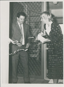 Uniting Church Archives - Synod of Victoria
Photograph, Opening of Kilmany Orbost new units by politicians, 05/1986
Kilmany Family Care Community Residential Units - ordinary community houses that are adapted for accommodation for up to six people with intellectual disabilities - opened at Orbost. See article on p. 25 of C&N for May 14, 1986.Caroline Hogg, Community Affairs Minister & Barry Murphy MLC snipping ribbon at opening of new units.Identification of persons & place.kilmany family care, hogg, caroline, murphy, barry mlc -
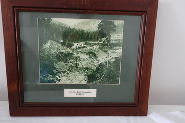 Kiewa Valley Historical Society
Set of 6 framed photographs - Kiewa Hydro Electric Scheme
Official photos - Kiewa Hydro Electric Scheme constructed by State Electricity Commission of VictoriaOfficial photos of KHES in the Kiewa Valley1. Junction Dam Excavation - 5th April 1941 2. Bogong Residential Area Development - 24th April 1940 3. Beginning of Mt Beauty Township - 20th February 1947 4.Pretty Valley Bridge - 9th September 1940 5. Junction Dam - General View from Downstream - 15th September 1943 6. Construction of Dam Wall for Rocky Valley Dam - 1958khes, secv -
 Kew Historical Society Inc
Plan - Subdivision Plan, Mount Ida Estate, 1925
The Kew Historical Society collection includes almost 100 subdivision plans pertaining to suburbs of the City of Melbourne. Most of these are of Kew, Kew East or Studley Park, although a smaller number are plans of Camberwell, Deepdene, Balwyn and Hawthorn. It is believed that the majority of the plans were gifted to the Society by persons connected with the real estate firm - J. R. Mathers and McMillan, 136 Cotham Road, Kew. The Plans in the collection are rarely in pristine form, being working plans on which the agent would write notes and record lots sold and the prices of these. The subdivision plans are historically significant examples of the growth of urban Melbourne from the beginning of the 20th Century up until the 1980s. A number of the plans are double-sided and often include a photograph on the reverse. A number of the latter are by noted photographers such as J.E. Barnes.The Mount Ida Estate was a subdivision of fifty-two residential allotments bordering Tooronga Road, Leura Grove, Constance Street, and Mount Ida Avenue in Hawthorn East. The report of the sale of the Estate in The Argus (21 September) claimed that over 1,000 people attended the auction and that all allotments were sold on the day. On the other side of Constance Street, the plan identifies the ‘Eastern Recreation Reserve’ (now Anderson Park).subdivision plans - hawthorn -
 Orbost & District Historical Society
belt, mid 20th century
This belt with badges was owned and worn by Nancye Wallace (nee Warren) as a Girl Guide leader in Orbost. The badges indicate that she took part residential camps as part of her membership. she continued in the Guiding movement as an adult leader.Established in 1910, Girl Guiding is now one of the largest all female organisations in the world. It is designed for girls, young and not-so-young women to join and enjoy a program of informal learning, opportunities, fun, personal development and friendship. (ref. Girl Guides Victoria). This whistle used by an Orbost local reflects the history of that organisation in Orbost.A brown leather belt with two badges attached. it has a silver metal buckle engraved with "Girl Guides association Be Prepared" and their emblem. One badge is a black and yellow Camp Kindaminda badge and the other a rectangular blue, green and gold Victoria Camp badge.Inside belt in black - N WALLACE ORBOSTbadges girl-guide-belt -
 Vision Australia
Administrative record - Text, Royal Victorian Institute for the Blind annual report 108th 1973-1974, 1970-1971
Articles in the annual report include: the possible acquisition of land at Burwood by the Government for a teacher college, photos of a trip to Falls Creek by students, the success of the only vocationally orientated residential centre for blind adults and the introduction of E.J. Hanlon as President.1 printed volume with photographsroyal victorian institute for the blind, annual reports -
 Eltham District Historical Society Inc
Slide - Photograph, Unidentified location, Eltham district, c.1992
35mm colour positive transparency Mount - Black and Whiteunidentified, infrastructure, streets, roads, footpaths and gutters, residential, streetscape -
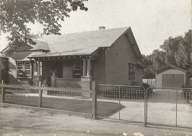 Bendigo Historical Society Inc.
Photograph - T C WATTS & SON COLLECTION: MERCY STREET, BENDIGO, 1930
BHS CollectionBlack and white photograph mounted on rectangular brown board. House, weatherboard, tile roof, 2 chimneys, woven crinkled wire fence, 4 gates, leadlight windows, weatherboard garage RH side of house, washing on line at back, porch with brick balustrade and concrete pillars. On back of photoboard ' King's, Mercy Street Street £1000'.Frank A. Jeffree, Bendigoplace, building, residential, stamped on back in rectangle ''t.c. watts and son/auctioneer/estate agents/253 mitchell street/bendigo'', stamped on back in circle ''royal historical society of victoria, bendigo branch'', handwritten on back ''kings/mercy street/1000pounds'' -
 Bendigo Historical Society Inc.
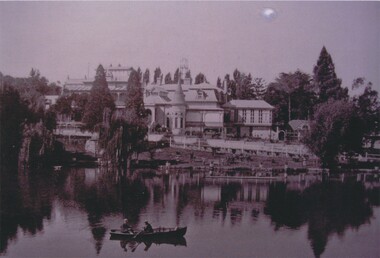
Photograph - FORTUNA COLLECTION: EXTERIOR VIEW OF FORTUNA VILLA
Black and White Photograph of the exterior of the Fortuna Villa, There are 2 men rowing in a boat in the centre of the photo, 'Piece of Paper contained with Photos could be the details of the possible donor reads 'Sandra McLachlan, 5 Chaple Cross Crt, Delecombe 3556, 0432 718 315, '[email protected], 5336 1220'buildings, residential, fortuna villa, fortuna villa, george lansell, christopher ballerstedt, fortuna -
 Bendigo Historical Society Inc.
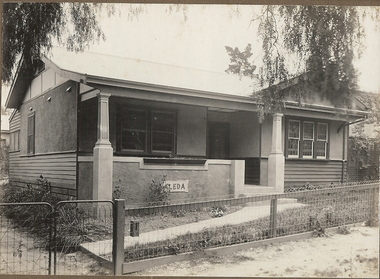
Photograph - T C WATTS & SON COLLECTION: GRAHAM STREET, BENDIGO, 1931
Black and white photograph mounted on rectangular brown board. House, weather board and cement render, corrugated iron roof, leadlight windows, woven crinkled wire fence. House name cast on verandar ''ALEDA'' On back of photo: Mrs. Fraser, Graham St. 1st. Off Russell St., 17 November, 1931. £625. Written in pencil 'reduced to £600 on 10 October, 1933' 2012 photo of house attached to record.Frank A. Jeffree, Bendigobuilding, residential, mrs fraser, graham street, bendigo, t.c. watts and son, aleda -
 Bendigo Historical Society Inc.
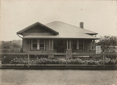
Photograph - T C WATTS & SON COLLECTION: 77 NEALE STREET, BENDIGO, 1930
BHS CollectionBlack and white photographs (2) mounted on rectangular brown board. House, weatherboard, corrugated iron roof, verandah, brick half pillars. Lattice fence at R.H.S., 1 chimney. Woven wire fence, child on veranda. On back of photo: Mr Whiffen, 77 Neale Street, £1030, sewered. 11 April 1930. T.C. Watts & Son, 253 Mitchell St., Bendigo.' On front of photo: Frank A. Jeffries, Photo, Bendigo'Frank A. Jeffree, Bendigobuilding, residential, t.c. watts and son, neale street, bendigo, frank a. jeffires, whiffen -
 Ringwood and District Historical Society
Photograph, Photos from a Weekly Times newspaper article featuring images of early Ringwood and East Ringwood circa 1910 (6 photos), Circa 1910
Shops, houses and hotel(s) were originally regarded as being in central Ringwood and later as Ringwood East after the commercial and residential developments gradually centered further west around the Railway Station precinct after train services commencedFive photographs; Ringwood Railway Crossing; Ringwood Shopping Strip; Pruning Demonstration; Shops, houses and hotel(s) in Mount Dandenong Road; Ploughing.Written on backing sheet, "Photos from Weekly Times. Check with H.A." -
 Uniting Church Archives - Synod of Victoria
Sign - Magnetic sign
The Uniting Church Synod of Victoria and Tasmania sold all its residential camps operated by UC Camping in June 2023. They were Grantville, Westernport Bay; Norval, Grampions/Gariwerd; Merricks Lodge, Mornington Peninsula and Adekate Camp, Creswick.White magnetic sign with the UCA symbol at the top, taupe coloured text and yellow and green images."Uniting Church in Australia SYNOD OF VICTORIA AND TASMANIA" "UC CAMMPING creating opportunities www.uccamping.org.au"uc camping -
 Bendigo Historical Society Inc.
Photograph - NEW CHUM MINE WORKINGS
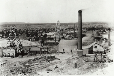
black and white photo ; ( copy ) view from Chum Hill, poppet heads, buildings and chimneys in middle foreground, residential area in background. On front 545. Back ' mining gold Bendigo Vic. Mine workings - near New Chum Mine. ' not to be reproduced without permission from the National Library. James Lerk 18.2.2000 ; ' view from Chum Hill, left Lazarus Mine, right Lansell's 222 looking south 'organization, business, new chum mine -
Clunes Museum
Map, Township of Clunes - Parish of Clunes - County of Talbot
Map of Clunes Township in 19511 X PHOTOCOPY OF MAP, (COMPRISING A NUMBER OF A4 SHEETS TAPED TOGETHER) SHOWING LOT NUMBERS AND NAMES OF LANDHOLDER. REFERENCE GAZ 1951.1480. SCALE 30 CHAINS = 1 INCH 1 X PHOTOCOPY OF MAP, (COMPRISING A NUMBER OF A4 SHEETS TAPED TOGETHER) SHOWING LOT NUMBERS AND NAMES OF LANDHOLDER. REFERENCE: G76359 GENERAL FILE TOWNSHIP RESIDENTIAL ALLOTMENTS SCALE 30 CHAINS = 1 INCHNOTATED IN PURPLE CRAYON ON SECOND MAP: AS AT LATE 1984 COPY OF MAP FROM LAND TITLES OFFICE BALLARATtownship of clunes map, 1951 -
Glen Eira Historical Society
Photograph - Frogmore
This folder is about the subdivision of 'Frogmore':A black and white photograph (140mm x 90mm) of a real estate advertisement for the sale of housing blocks on the residential development Frogmore Estate, Murrumbeena. The advertisement includes a plan showing the location of the housing blocks and the surrounding roads.murrumbeena, carnegie, frogmore estate, neerim road, gnarwyn road, coorigil road, moonya road, woornack road, rosstown railway, carool road, warina road, murrumbeena road, frogmore road, wahgoo road, hethersett grove, hethersett, thomas j g, plans, housing estates, rosstown, caulfield council, land subdivision