Showing 6760 items matching " rivers"
-
 Orbost & District Historical Society
black and white photograph, 1913
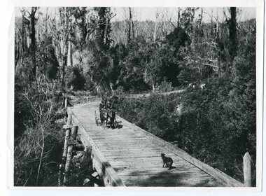
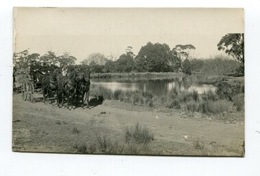
This photograph is of the low level bridge across the Bemm River about 50 km east of Orbost in East Gippsland.This is a pictorial record of the 1913 low level bridge across the Bemm River, East Gippsland.A large black / white photograph of a horse - drawn wagon on the low level Bemm River bridge. In the foreground on the bridge is a dog.on back - "Country Roads Board Princes Highway low level bridge" -
 Orbost & District Historical Society
photograph, first half of 20th century prior to 1976
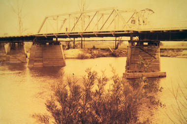
Purchased from Orbost Op shop several years ago. Original owner unknown. This bridge over the Snowy River was opened on July 4 1922. It was constructed in 1922 alongside the previous suspension bridge. Its building was a combined effort of the Victorian Railways and the Country Roads Board at a cost of 35,000 pounds. It was replaced in 1976 by the present bridge after several major floods.This bridge was replaced in 1976 after several major floods.A wooden framed photograph of the second Snowy River bridge at Orbost.photograph snowy-river-bridge -
 Stawell Historical Society Inc
Book - Guide Book, The Emigrant's Friend
Faxsimile Reprint of 1848 booklet printed in London J. Allen warwick, Paternoster Row: D. Francis Mile End Road. May be had of all Booksellers. Inlcudes what Emigrant must provide at minimum when on passage to the colonies.Paper Back, Fawn cover: Brown print Seals of Australia, New Zealand, Van Dieman's Land, and the Seal of Swan River.Seal of New Zealand Seal of Australia [Picture of Seal] [Picture of Seal] The Emigrants friend or Authentic Guide to South Australia Including Sydney: Port Philip or Australia Felix: Western Australia, or Swan River Colony: New South Wales: Van Dieman's Land; and New Zealand original published in London in 1848. Recreated by Reader's Digest Sydney [Picture of Seal] [Picture of Seal] Seal of Van Dieman's Land [Seal of Swan River] -
 Lakes Entrance Historical Society
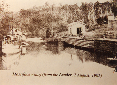
Photograph - Mossiface Wharf, Mossiface wharf at Mossiface Victoria 1902, 1902
... Rivers ...Sepia photograph showing S S Lady Harriet and barge at Mossiface wharf on Tambo river near Bruthen, Lady Harriet on left barge on right at wharf store shed and crane on wharf, small building far right, forested hill at back, stern of small rowing boat at lower right in photograph. Mossiface Victoria 1902Mossiface wharf (from the Leader, 2 August 1902)jetties, transport, ships and shipping, rivers -
Tatura Irrigation & Wartime Camps Museum
Photograph, Big Eildon Project, 1953
Taken by photographer for State Rivers and Water Supply Commission.Large sepia photograph. Earthmoving equipment in right foreground and middle distance, men scattered around site working, side of hill being excavated, rounded hills beyond forming horizon.Below photo: "BIG EILDON PROJECT / Construction of Embankment across Goulburn River Bed / Work commenced November 1953." victoria state rivers and water supply commission, eildon, goulburn river -
 Kew Historical Society Inc
Photograph, Chipperfield's Boat House & Floating Pontoon, c.1939
Several boathouses were built in Kew and Fairfield in the late 19th and early 20th centuries. They included Chipperfield’s ‘Moorings’ and floating pontoon. The substantial two-storey house was named the Moorings, and incorporated an upper storey residence. The Moorings was almost washed away in the 1916 floods, and in 1934 almost totally submerged when the Yarra River rose 26 feet in 14 hours. Following the 1934 flood, the house was restored. The floating pontoon, sometimes referred to as a ‘kiosk’ or ‘canteen’, was used to store canoes. Both were removed in 1972 for the construction of the Eastern Freeway.This work forms part of the collection assembled by the historian Dorothy Rogers, that was donated to the Kew Historical Society by her son John Rogers in 2015. The manuscripts, photographs, maps, and documents were sourced by her from both family and local collections or produced as references for her print publications. Many were directly used by Rogers in writing ‘Lovely Old Homes of Kew’ (1961) and 'A History of Kew' (1973), or the numerous articles on local history that she produced for suburban newspapers. Most of the photographs in the collection include detailed annotations in her hand. The Rogers Collection provides a comprehensive insight into the working habits of a historian in the 1960s and 1970s. Together it forms the largest privately-donated collection within the archives of the Kew Historical Society.Chipperfield's Floating Canteen (also known as the pontoon) on the Yarra River. at North Kew The children wading in the river are believed to be the three sons of Dorothy Rogers."Chipperfield's Floating Canteen & house in background. At extreme right - observe channel where Connors Creek flows in."chipperfield's boat house, river yarra, dorothy rogers, floods 1916, 1934 -
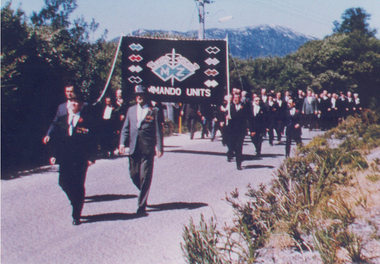 Australian Commando Association - Victoria
Photograph, Inaugural march of M& Z Commando Association members at The Australian Commando Memorial at Tidal River 16 November 1964
The WW2 Commando memorial cairn was unveiled at Tidal River on 15 November 1964 by the Lieutenant Governor of Victoria Lieutenant General Sir Edmund Herring. Former WW2 Commandos march under their Association banner to the cairn for the dedication ceremony.This was the first dedication of a significant WW2 Commando memorial. The Victorian Governor, Lieutenant General Sir Edmund Herring, unveiled the Commemorative Cairn that has become the de facto national Commando memorial.Rectangular colour glossy print photograph of former WW2 Commandos marching at Tidal River.From Don Bergmanww2, world war ii, australian commandos, independent companies, australian commando association, tidal river, wilsons promontory national park -
 Orbost & District Historical Society
black and white photograph, late 19th - early 20th century
This photograph was taken at the junction of the Snowy and Brodribb Rivers. The Snowy River starts in New South Wales on the slopes of Mt Kosciuszko, Australia’s highest mountain, in New South Wales. It flows into Bass Strait at Marlo in Victoria. The Brodribb River is a tributary of the Snowy which enters the estuary at Marlo. This is a pictorial record of a road in Marlo near Orbost in the late 19th-early 20th centuries. It also depicts the transport used at that time.A black / white photograph of four men in suits seated in a horse - drawn buggy on a dirt road alongside a creek or river. There appears to be another horse - drawn vehicle behind them.on back - "at the Brodribb - Snowy junction. this road was corduroy (packed logs of tea trees?)brodribb-river snowy-river marlo transport-horse-drawn -
 Orbost & District Historical Society
black and white photographs, 25.11.1976
These photographs were taken on November 25, 1976 at the official opening of the current Snowy River road bridge. Included in the photographs are: John Duggan; Pat Hall, C.R.B. chairman, R.E.V. Donaldson (3240.7) and J.A.Rafferty, the state minister for Transport, who cut the ribbon (3240.8). Di Young and Cheryl Dusting (3240.9) distributed souvenir information pamphlets to official guests. The Snowy River road bridge is one of four built as part of the 8.4 km project spanning the Orbost flood plains. The Snowy River bridge and another over the nearby Ashbys Gulch are among the 10 longest bridges in Victoria, being the eighth and fifth longest respectively. The new bridge removed through traffic from Orbost township crossing the Snowy River 45 m downstream of the old bridge.This bridge is the fourth to provide a crossing to the township of Orbost. (info from CRB NEWS No. 34. DECEMBER, 1976) These photographs are pictorial records of a significant event in Orbost's history.Eleven black / white photographs all related to the official opening of the current Snowy River Bridge. Details are in catalogue folder.snowy-river-bridge -
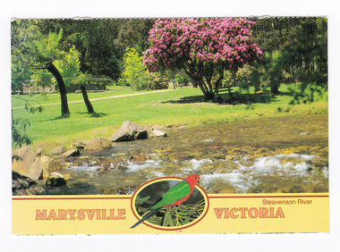 Marysville & District Historical Society
Postcard (item) - Colour postcard, Neil Cutts, Marysville Victoria-Steavenson River, Pre 2009
A postcard in a series produced by the Rose Stereograph Company in Victoria, Australia as a souvenir of Marysville.A colour photograph of the Steavenson River which flows through Marysville in Victoria. The Rose Series postcard No. 3527.POST CARD The "Rose" Series/ De Luxe Proudly Printed in/ Australia Since 1880 AFFIX/ STAMP/ HERE/ Rose Series/ Post Card No./ 3527 ADDRESS/ POSTCODE Steavenson River/ MARYSVILLE, VICTORIA, AUSTRALIA/ Photo Neil Cutts Copyright Rose Stereograph Co., Glen Waverley, Victoria (03) 9560 7772marysville, victoria, steavenson river, postcard, souvenir, rose stereograph co, 3527 -
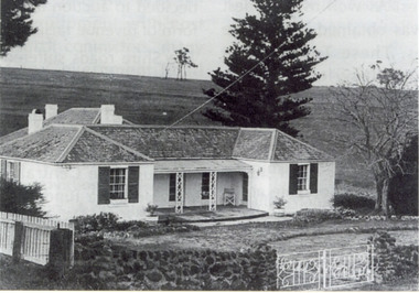 Federation University Historical Collection
Photograph, Somerset Inn, Bannockburn
The Somerset Inn was built for Edward Carter Holmes by carpenter Isaac Sutherland and his two sons in 1855/1856. Situated on Bruce's Creek on the Shelford - Bannockburn Road. Bruce's Creek was the original name for current day Bannockburn. Black and white photograph of a house with slate roof and window shutters. The front fence is stone. The house is the former Somerset Inn (later a private residence). This building is located on the Leigh River at Bannockburn and was the home of Edward Carter and Sarah Holmes. Verso in blue ball point pen. "Somerset Inn on Leigh river Bannockburn. Home of Edward C. & Sarah Holmesholmes, leigh river, sarah holmes, ec holmes, holmes family collection, chatham-holmes family collection, edward carter holmes, farm, bannockburn -
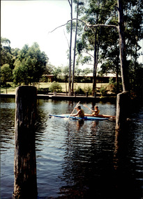 Melbourne Legacy
Photograph - Junior legatee outing, Kayaking, 1990s
Legacy have many programs to send junior legatees on activities, camps and outings. The photos are of junior legatees kayaking on a river. It was possibly part of a camp. The date is not known though it was stored with other photos of Junior Legatees from the 1980s and 1990s. A record of a Legacy providing experiences for the junior legatees.Colour photo x 4 of Junior Legatees kayaking on a river and returning the kayaks to a shed.junior legatee outing, kayaking, kayaks -
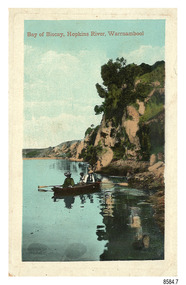 Flagstaff Hill Maritime Museum and Village
Postcard - Scenic - Warrnambool, Bay of Biscay, Hopkins River, Warrnambool, 1902-1910
The nine postcards in this set were donated together and date to the early 1900s. All but one postcard in this set shows images of Warrnambool, in the Western District of Victoria; the other has a London image. The postcards were all printed in Great Britain according to that country’s postal regulations. The fronts of all cards have titles printed in red. Most of the images on the cards are attributed to photographer Joseph Jordan and belong to the Jordan Series. The back of these cards has an outline for a postage stamp, a vertical dividing line and a heading on each side of the line to separate the Correspondence from the Address. Postcards or ‘correspondence cards’ appeared in Britain in 1894. They were plain cards with a space for the message on one side and an address on the other; regulations didn’t allow anything but the address to be written on the ‘address’ side. In 1902 the British regulations then allowed a picture to be printed on the front and the address on the back, so messages had to be written on the picture side. Soon, the regulations changed and the back was divided for a message and the address. Bay of Biscay, Hopkins River, Warrnambool – This same image was published in Table Talk on January 6th, 1910 and in The Age, on December 18, 1929, referred to a revival of fishing at the Bay of Biscay on the Hopkins River. These and similar articles showcased the Bay of Biscay as a popular boating and fishing location and well worth promoting to places outside of Warrnambool. Joseph Jordan - Joseph Jordan was born in 1841 in Leicester England. When he was 16 he joined the 7th Queen's Own Hussars and was sent to India at the outbreak of the mutiny. He took part in the relief of Lucknow and remained in India for eleven years. It was during this time that he became interested in photography. He was posted to New Zealand and later came to Victoria, becoming a sergeant major of the Mounted Rifles. In the mid-1880s he came to the Western district where he was responsible for establishing units of the Mounted Rifles in various country towns such as Dunkeld, Mortlake, Panmure, Bushfield, Koroit etc. He resigned from the army in 1889 and set up a professional photography studio in Liebig Street, Warrnambool. He became very well known in the Western District for family photographs, official photographs of local councillors and groups as well as views of local scenery. In 1891 he photographed the wrecked barque ‘Fiji’ at ‘Wrecks Beach’ near Princetown. His business was taken over by his son Arthur around 1917. Joseph was a keen rifle shot and in 1924 he donated the "Jordan Shield" as a prize to the Victorian Rifle Association. He was made a "Life Honorary Member" of the Warrnambool Returned Soldiers League and in 1933 he was recognised as being the oldest living soldier in Victoria. Joseph died in 1935 aged 95.The image of the figures in a row boat on the river suggests that the location was a popular place to visit. The choice of subject for this postcard indicates the popularity of Warrnambool's natural environment as a tourist attraction at a time when ships called coastal traders brought passengers and cargo to the Port of Warrnambool from ports along Victoria's southwest coast. Joseph Jordan is a significant figure in Warrnambool history as he helped to establish early units of the Mounted Rifles (G Company) in local towns during the late 1880's and later, photographed local scenes, groups and citizens of early Warrnambool.Postcard, one of nine, portrait orientation, coloured print within a rectangle border with an impressed line around the image and a title in red. The picture shows three figures wearing hats in a rowboat on the bank of a river beside cliffs. There is no correspondence written on the card. The back has inscriptions and outlines for a postage stamp. Jordan Series, printed in Great Britain.Front, in red: “Bay of Biscay, Hopkins River, Warrnambool” Back in green: “Jordan Series” “POST CARD” “PRINTED IN GREAT BRITAIN” “For correspondence” “The Address only to be written here”flagstaff hill maritime museum, flagstaff hill maritime village, flagstaff hill maritime museum and village, maritime museum, warrnambool, great ocean road, warrnambool and district, warrnambool scenes, local scenes, views of warrnambool, joseph jordan, jordan series, jordan photography, postcard, souvenir, correspondence, cameo postcard, bay of biscay, fishing, boating -
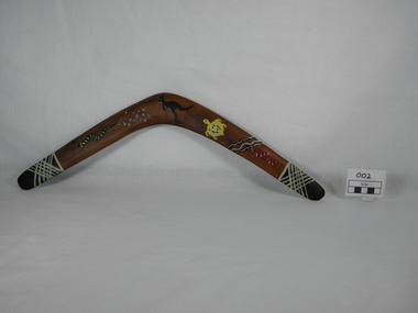 Bunjil Park Aboriginal Education & Cultural Centre
boomerang, (estimated); late 20th century
boomerang made from Murray River Red Gum timber. decorated boomerang, used for killing low flying ducks. Each end has a black tip with white cross hatching. Animal painted decorations from left to right are: black snake with yellow stripes, ochre platypus, black coloured kangaroo, yellow turtle, black, ochre and white wavy lines followed by a red snake with black and white stripes. On reverse apex of boomerang burnt into timber "Murray River / Red Gum"platypus, boomerang, river, decorated, hunting tool, snake, turtle, kangaroo, creek, duck hunting, ducks, jaara jaara, jaara jarra people -
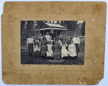 Myrtleford and District Historical Society
Photo, F.Foxcroft, Buffalo River South State school, 1913
1913 School photo of Buffalo River South State School. The school was 21 Km south of Myrtleford. 1913 Five members of the Fletcher family attended the school : Middle Row: Agnes (far left),Elizabeth(3rd from left ) Bruce (2nd from Right)Jeanette (far right), Front Row: Jean (2nd from left) Head Master: Mr Septimus Elmore Reference from 'Recollections IV ' (The Myrtleford & district Historical Society Inc February 2011) School photo of a remote school which was greatly impacted by fluctuating enrollments ,threatening its ongoing existence. the importance of numbers from single Family. clothes worn at this time Rectangular beige stained cardboard with an inserted emboss border surrounding a Sepia color photo. Buffalo River S.S. School. F.Foxcroft photo Brightmyrtleford,victoria,buffalo river, school, fletcher 1913 -
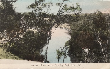 Kew Historical Society Inc
Postcard, The VSM.Series, No.351. River Yarra, Studley Park, Kew, Vic, c.1905
This is a colour postcard of the River Yarra at Studley Park, circa 1905. The postcard, which has handwritten notes on the reverse. It was printed in Prussia as part of the Victoria Stamp Market (VSM) Series. Coloured postcard of the Yarra River looking north from Galatea Point, near the Johnson Street Bridge.Donated by Miss B. Challen. ?Taken from bend above Galatea Point, looking north. Identified by Darcy Dugan, Yarra Bend Parks.river yarra, victoria stamp market (vsm) series, postcards -
 Wodonga & District Historical Society Inc
Album - Ringer's River by Des Martin - Plate 8 - O'Day meets Grapeshot
Pushing his mob along the back boundary of Barmagulla Station, whose owner, Edmund Montieth, a wealthy, well educated, and forward thinking gentleman accepted as a leader of the N.S.W. pastoralists "just across the border", O'Day hears the shrill whinny of a stallion. On riding over to investigate he finds that, in the practise of the day, a superb thoroughbred horse has been turned out on the river flats to acclimatise. Later he learns that this is Grapeshot, a classic winner just imported from England.The albums and images are significant because they document literature written by a prominent member of the Wodonga community. The presentation of this precis was supported by several significant district families and individuals.Ringer's River Album Coloured photo Plate 8des martin, many a mile, ringer's river, northeast victoria stories -
 Orbost & District Historical Society
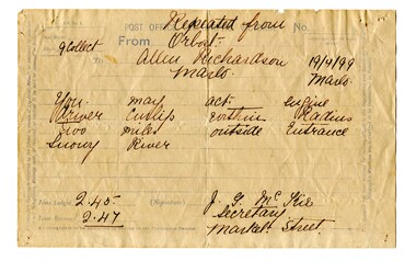
telegram, April 1899
This message concerned the P.S. Curlip's entry to the Snowy River Lakes Entrance. It was logged at 2:45 and received at 2:47.This item is associated with the P.S. Curlip and the Richardson family, early Orbost pioneers.A white paper telegram with blue print and details hand-written in black ink. It has been sent fro Orbost to "Allen Richardson Marlo". The handwritten message is difficult to decipher."You may enter - engine driver Curlip within two miles outside Entrance Snowy River."telegram-richardson-curlip communications-19th-century -
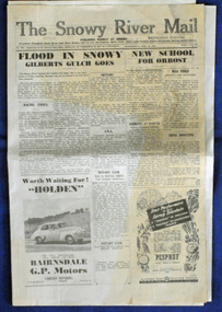
 Orbost & District Historical Society
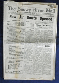
newspaper, Snowy River Mail, 29.3.1950
The Snowy River Mail is a weekly newspaper published in Orbost in the Shire of East Gippsland, Victoria, Australia. Previously published as The Snowy River mail and Tambo and Croajingolong gazette from 1890 to 1911. The Gippsland Courier merged with the Snowy River Mail when proprietor Lachlan Ross moved to Orbost in 1910. In 1999 the paper was acquired by the Yeates family when the Hollins family retired from the newspapers business. The paper is still being produced by the fourth generation of the Yeates family as part of East Gippsland Newspapers. The 1950 flood was a significant event in Orbost. This newspaper is a contemporary record of a significant local events.A Snowy River Mail newspaper dated 29.3.1950. It contains news articles and advertisements in black/white print. it contains an article on the flood at that time.snowy-river-mail 1950-flood newspaper -
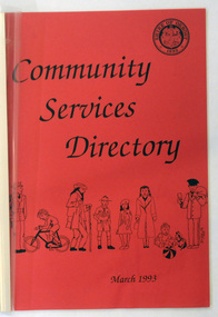 Orbost & District Historical Society
book / document, Community Services Directory March 1993 Shire of Orbost, 1993
This booklet was compiled by Orbost Shire council in 1993. It contains addresses and phone numbers of community groups in the shire and includes Mallacoota, Bemm River, Marlo, Cann River and Orbost.I it also has population statistics from the 1991 census - 6562 or the Shire of Orbost.This booklet is a useful reference tool.A foolscap sized document of approximately 60 pp titled COMMUNITY SERVICES DIRECTORY Shire of Orbost March 1993.It has a red cover with plastic binding. It contains addresses and phone numbers of community groups in the shire and includes Mallacoota, Bemm River, Marlo, Cann River and Orbost.I it also has population statistics from the 1991 census - 6562 or the Shire of Orbost.orbost-history community-groups-orbost-1993 -
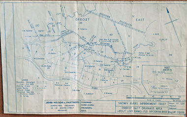 Orbost & District Historical Society
plan, December 1968
Brodribb floodplain regularly inundated in the late 1800s and early 1900s. Works included: clearing the river channel and blocking ‘gulches’. The meander was cut-off in 1931, as part of the Orbost East Drainage Scheme and further developed after 1934 floods and again in the early 1950s when levee banks and a regulator were constructed. (ref. East Gippsland Catchment Management)This is a useful reference tool.A hand-drawn plan of the layout of the levee banks of the Old Brodribb River.brodribb-river map plan-levee-banks -
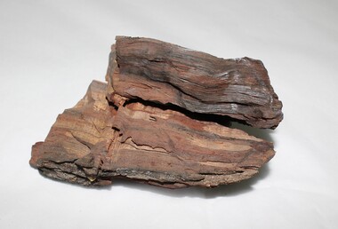 Wodonga & District Historical Society Inc
Geological specimen - Murray River Red Gum Geological Specimen c. 6000 BP
This wood was cut from a 6000 year old Murray River red gum retrieved from the Wodonga gravel pits on the flood plain. The Museum of Victoria displayed this wood in the base on which Phar Lap stands. It was made by Kevin Barton of the Kiewa Valley to the order of Dr. James Bowler, the geologist who dated the ancient gravel pit red gums. This specimen is historically significant and unique in local, national, and international context. It is unique, of scientific and research value, and exceptionally rare due to its age. 6000 year old wood from a Murray River red gum. geology, geological, murray river, red gym, murray river red gum, kiewa, wodonga, history -
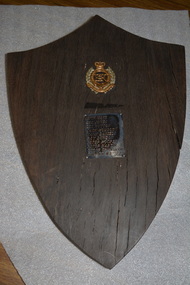 Wangaratta RSL Sub Branch
Memorabilia - Shield, Original punt was made in the mid 1800s. shield was made by Jim Sloan in early 1970s
Red gum shield was made from a piece of the Ovens River punt which served as a river crossing at the Sydney Hotel two centuries ago and which had lain on the river bed for approximately 100 years. The punt was raised by members of the Royal Australian Engineers whose names, unit and badge apear on the shield in the early 1970s.Red gum shield was made from a piece of the Ovens River punt which served as a river crossing at the Sydney Hotel two centuries ago and which had lain on the river bed for approximately 100 years. The punt was raised by members of the Royal Australian Engineers whose names, unit and badge appear on the shield in the early 1970s. In 2019, after nearly 70 years at Balcke House, the Wangaratta RSL Sub Branch will take up new residence at the Sydney Hotel.Red Gum timber in shape of shield with crest and plaque.Crown of Australian Engineers above a list of the soldiers who worked on the project. Attached is a card which states :- This red gum shield was made from a piece of the Ovens River punt which served as a river crossing at the Sydney Hotel two centuries ago and which had lain on the river bed for approximately 100 years. The punt was raised by members of the Royal Australian Engineers whose names, unit and badge appear on the shield in the early 1970s. It was made and presented to the Wangaratta RSL by Jim Sloan of Wangaratta.ovens river, sydney hotel wangaratta -
 Orbost & District Historical Society
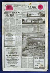
newspaper, Snowy River Mail, 27.7.1983
The Snowy River Mail is a weekly newspaper published in Orbost in the Shire of East Gippsland, Victoria, Australia. Previously published as The Snowy River mail and Tambo and Croajingolong gazette from 1890 to 1911. The Gippsland Courier merged with the Snowy River Mail when proprietor Lachlan Ross moved to Orbost in 1910. In 1999 the paper was acquired by the Yeates family when the Hollins family retired from the newspapers business. The paper is still being produced by the fourth generation of the Yeates family as part of East Gippsland Newspapers Thisnewspaper is a contemporary record of a significant local events.A Snowy River Mail newspaper dated 27.7.1983. The main story is "Blaze at Golf Club". It contains news articles, photographs and advertisements - black/white.newspaper snowy-river-mail orbost-golf-club -
 Orbost & District Historical Society
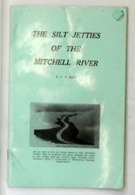
book, James Yeates & Sons (Printing) Pty Ltd, The Silk Jetties of the Mitchell river, 1972
This booklet was the first of a series of scientific and historical studies of Gippsland to be published by the Bairnsdale Advertiser. The author, Eric Charles Frederick Bird was Principal Fellow, Department of Geography, University of Melbourne, Australia. The Mitchell River silt jetties are an unusually long, thin landform located in the Gippsland Lakes region. They have been formed over millions of years by sediment deposition from the Mitchell River during periods of low water flow and subsequent wash-through during periods of high water flow. The long narrow banks of silt extend more than eight kilometres east into Lake King. This item is a useful reference for the silt jetties of the Mitchell River.A 32 pp book with alight green cover. The title is in black print, " The Silk Jetties of the Mitchell River" and underneath the title there is a b/w photograph of the Mitchell River and silt jetties taken from above in 1931. It was written by E. C. F. Bird.silt-jetties mitchell-river paynesville bird-e.c.f. -
 Kiewa Valley Historical Society
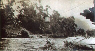
Photo - Tawonga Bridge.( Set of 2 photos)
Photo 1 - Rene Roper (Postmistress) crossing swollen Kiewa River on a milk can flying fox at Tawonga, during high winter waters Photo 2 - First Tawonga bridge was built in 1884- destroyed by floods in 1916. New bridge constructed 1923 and destroyed in 1953. Present concrete bridge constructed in 1986 and named Ryders BridgeBridge construction over Kiewa River at TawongaCopies of two original black and white photos. Photo 1 - Flying fox at site of Tawonga Bridge over the Kiewa River Photo 2 - Timber pile bridge over the Kiewa River at Tawongatawonga bridge, kiewa valley -
 Orbost & District Historical Society
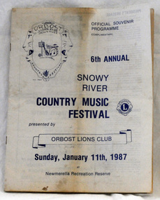
souvenir program, 1987
The annual Snowy River Country Music Festival was organised by the Lions Club of Orbost and held at the Newmerella Recreation Reserve. The 6th event was held on Sunday, Jan 11 1987.This program is significant in that it is a souvenir of a local event which no longer takes place.An official souvenir program for the 6th annual Snowy River Country Music Festival, 1987. B/W print.snowy-river-country-music-festival program souvenir -
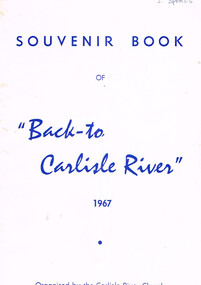 Otway Districts Historical Society
Book, "Back to Carlisle River", 1967
The settlement and settlers of Carlisle River, first known as "New Church Run" in 1861 until its name change in 1890-91.Souvenir bbok of "Back to Carlisle River", 1967. Colac (Vic); Herald Print; 1967. 25 p.; illus. Soft cover.Under Hotel, an insertion entitled "The Carlisle Hotel" containing the names of the licencees until its surrender on 31 December 1928.carlisle river; new chuch run; butter; history; sport; -
 Orbost & District Historical Society
newspaper, 15.2.1950
The Snowy River Mail is a weekly newspaper published in Orbost in the Shire of East Gippsland, Victoria, Australia. Previously published as The Snowy River mail and Tambo and Croajingolong gazette from 1890 to 1911. The Gippsland Courier merged with the Snowy River Mail when proprietor Lachlan Ross moved to Orbost in 1910. In 1999 the paper was acquired by the Yeates family when the Hollins family retired from the newspapers business. The paper is still being produced by the fourth generation of the Yeates family as part of East Gippsland Newspapers. The flood in 1950 was a significant Orbost event. This newspaper is a contemporary record of a significant local events.A Snowy River Mail newspaper dated 15,.2.1950. It contains news articles and advertisements in black/white print. There is an artcle about the Orbost floods.newspaper snowy-river-mail flood-1950-orbost -
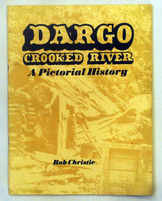 Orbost & District Historical Society
book, Enterprise Press Pty Ltd, Dargo Crooked River, C 1994-1997
This is a pictorial history of the Crooked River district.This is a useful reference tool on the history of gold mining in the Dargo area.A thin 56 pp paperback book titled,"Dargo Crooked River a Pictorial History". On the yellow front cover is a sepia photograph of a man standing outside a rough wooden hut. The title and author are printed in black text over this. The book contains Black / white photographs and the history of Dargo and Crooked River. The information is divided int decades. Inside there is a newspaper cutting of Victorian cattlemen on Junction Plain near Omeo.dargo-crooked-river gold-mining east-gippsland-history