Showing 2471 items matching " township"
-
 Lakes Entrance Historical Society
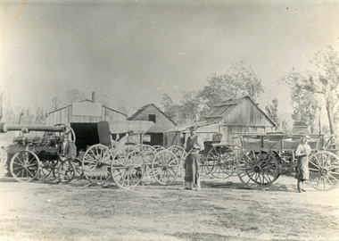
Photograph - Harry Froud's coach factory, P Hancock, 1900 c
Henry Froud's Blacksmith Coach Building and Wheelwright's business set up at original surveyed site west of present township, nearer to cemetery turnoff,. Business first moved to corner of Princes Highway and Bruthen Road, (now site of Black Stump Store), then moved to premises built by Harry Froud on south side of highway, corner of Punt Road, (present site of BP Garage).Black and white photograph of Harry Frouds first coach factory west of present township, showing three men in front of four wheeled vehicles including a steam engine. Three workshops in background, two having bark roofs, man in centre identified as Harry Froud, William Henry. Johnsonville Victoria. transport, factory, people, local history -
 Bacchus Marsh & District Historical Society
Map, Plan of the second portion of the property of Messers Atkins and Clarke situate at Bacchus Marsh 1856
This plan of land allotments for sale indicates part of the property once owned by the Bacchus family in and around the township area of Bacchus Marsh. The Bacchus family sold their property in Bacchus Marsh to John Aitkins and Robert Nalder Clarke in March 1851. Aitkins and Clarke kept the property for a number of years until April 1856 when these allotments were put up for sale.This is a very early land sales plan for agricultural land close to the township of Bacchus Marsh. It therefore provides some clues as to how the early urban development of the township and agricultural development of the nearby area took place. Upon seeing the map in 1911 Bacchus Marsh Express newspaper editor Christopher Crisp wrote "The sale appears to have created the present township, which had a nucleus in earlier times further east", Express, 30 September, 1911, page 3.A single page paper plan showing allotments of land for sale. The subdivided land shown was owned by John Aitkins and Robert Nalder Clarke, but previously owned by the Bacchus Family and was in and around their Manor House (Mansion) property in Bacchus Marsh. This plan shows allotments in the second portion of land to be sold which was located east of the Manor House on the eastern side of the Lerderderg River. The land for sale was made up of 15 allotments. The plan is pasted into a bound volume containing 76 maps or plans in total. BMDHS Loc: AR/B12/S4 Bacchus Marsh Township and Nearby Districts Maps Volume In-house Digital copies: BMDHS, Computer Network: Maps\Bacchus Marsh Township and Nearby Districts Maps Volumebacchus marsh victoria maps, bacchus family, land sales, manor house bacchus marsh -
 Lakes Entrance Historical Society
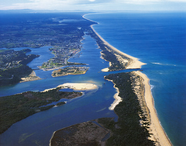
Photograph - Lakes Entrance, 1985c
Photo was cut from Tourist brochureColour photograph showing aerial view of township and the Ninety Mile Beach. Pecks factory on Bullock Island, Old North Arm bridge, bitumen for carpark for future. Fishermen's Club near North Arm Bridge. Photo shows East end of Rigby Island and Snake Island. Glimpse of Red Bluff, Lake Bunga and Lake Tyers in far east. Lakes Entrance Victoriabridges, coast, waterways, topography, township -
 Bacchus Marsh & District Historical Society
Map, 'Map of Darley' circa 1877-1897
This map shows the early laid out streets and roads for the village of Darley and the main roads and streets in the central area of the township of Bacchus Marsh. The date of the map is not known. Landmarks indicated on the map including the Anglican Church in Church Street (Gisborne Road), opposite the Presbyterian Church, and the Baptist Church at its pre-1898 Main Street location suggest the map is dated between 1877 and 1897. Landholders names can be seen on some of the allotments of land marked in this map, including the names Clifton, Cosgrove, O'Hagan, McFarlane, Nagle, O'Hagan, Simpson and Vallence.A single page paper map showing the village of Darley and the township of Bacchus Marsh. Scale 10 chains to 1 inch. The map is pasted into a bound volume containing 76 maps or plans in total. High resolution digital image stored on BMDHS computer network. darley victoria maps, bacchus marsh victoria maps -
 Clunes Museum
Album - PHOTO ALBUM
Photo album prepared for application in 1990 "Tidy Town" CompetitionExample of community pride and co-operationLeather look photo album, embossed, gold lettering, containing photos, descriptions, and itinerary of judge of competitionEntry of Clunes township in tidy town competition 1990 (inside front cover)photo album, tidy town competition -
 Clunes Museum
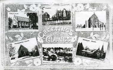
Photograph, UNKNOWN
.1 .2 PHOTO COPY OF A POSTCARD OF THE CHURCHES, HOSPITAL AND TOWNSHIP OF CLUNESGREETINGS FROM CLUNESlocal history, photography, photographs, churches, hospital and township -
 Bendigo Historical Society Inc.
Map - MANDURANG, No date visible
Map: It has the Village of Mandurang on one side and the Township of Laanecoorie on the reversemap, bendigo, parish plan, mandurang, laanecoorie -
 Lakes Entrance Historical Society
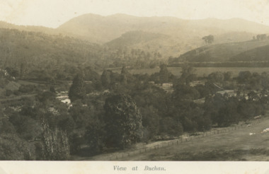
Postcard, H D Bulmer, Little River Falls , Wulgulmerang near Buchan Victoria, 1915 c
Black and white postcard of the countryside and hills surrounding township of Buchan VictoriaView of Buchanagriculture, topography -
 Ringwood and District Historical Society
Map - State Aerial Survey, Dandenong Ranges Area Sheet 7, Parishes of Warrandyte, Scoresby, Ringwood and Nunawading - 1956
Map of central and southern areas of Ringwood and part of Ringwood East and Heathmont compiled by Dept of Lands and Survey, July 1956, from aerial photographs and Cadastral Survey information. Subsequent coloured hand-drawn additions showing layout of a number of post-NSW Separation era proposed subdivisions that did not eventuate, including Village of Studley Estate, Township of East Kew Estate, Township of Ballyduffy Estate, Township of New Flemington Estate, Township of East Hawthorne Estate. Ringwood A4B2, 849 A4B Zone 7. Scale: 10 chains to 1 inch. Contour interval 20 feet. -
Bendigo Historical Society Inc.
Map - TARNAGULLA : COUNTY OF BENDIGO, 13-5-22
Map. County of Bendigo, County of Gladstone.Inglewood, Glenalbyn, Kingower, Moliagul, Waanyarra, Laaneoorie, Woodstock, Loddon River, Township of Tarnagulla, Township of Newbridge, Township of Llanelly, Dunolly to Inglewood Railway, Tarnagulla Rifle Range, Laurie Station, Bullabul Creek, Arnold Township, Arnold Railway Station. Photo-Lithographed at the Department of Lands and Survey, Melbourne by W.J. Butson, 13-5-22.Price 1/-.By authority A.J. Mullett, Government Printer, Melbourne. (number 118 in map cupboard 1)A.J. Mullett, Government Printer, Melbourne.map, bendigo, tarnagulla -
 Lakes Entrance Historical Society
Postcard - Backwater, Bulmer H D, 1922c
Black and white photographic postcard, showing early aerial view of township of Lakes Entrance, Cunninghame Arm, North Arm and sand dunes, ocean in lower foreground, Eastern wharf and various boats on lake. Princes Highway went along Esplanade, Myer Street and Roadknight Street, very little vegetation on sand dunes, no foot bridge yet, good view of North Arm, few houses. Lakes Entrance VictoriaLakes Entrance and Backwater from the Air.islands, aerial photograph, waterways, topography, township -
 Kiewa Valley Historical Society
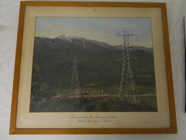
Framed photo - Mt Beauty Township & Main Transmission Line, 1954
This is a photo of Mount Beauty taken from a high vantage point near the hair-pin bend on the Tawonga Gap Road (half way up) in 1954. Mount Beauty was built by the State Electricity Commission of Victoria during the construction of the Kiewa Hydro Electric Scheme.This photo belonged to Mr & Mrs Gordon White SECV employee and long time residents of Mt Beauty.This is a framed coloured photo of the Mount Beauty Township and main Transmission Line from Mt Beauty to Kiewa. The photo has two transmission lines in the foreground with the Mt Beauty township in the background, but at the foot of Mount Bogong.Approx 1954 / Conroy-Moffatt Pty Ltd / Picture Framer / ..McKillop Street / Tel Mu .. 78 ....mt beauty; transmission line; tawonga gap road; kiewa hydro electric scheme -
 Phillip Island and District Historical Society Inc.
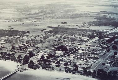
Photograph, 1940's 1950's
Photograph donated by John JanssonBlack & White aerial view of the Cowes Township and jetty area, Phillip Islandcowes phillip island, aerial view of cowes, cowes jetty, cowes pier phillip island, john jansson -
 Phillip Island and District Historical Society Inc.
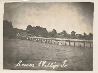
Photograph, Early 20th Century
One of a collection of 8 photographs donated by Bob Notley of San RemoBlack & White photograph of the Cowes Pier looking towards sheds and Cowes Township.Cowes, Phillip Is.cowes pier, cowes jetty, bob notley -
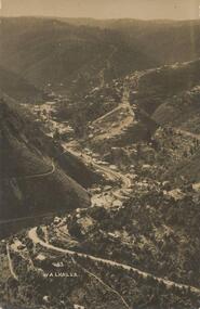 Phillip Island and District Historical Society Inc.
Photograph - Post Card, Late 19th Century
Photograph donated by Jean ArchibaldBlack & White Photograph of the road winding through the hills of Walhalla township, VictoriaFront: "Walhalla 43" Back: "To M with love from G W" "write soon"walhalla victoria, jean archibald, mining town -
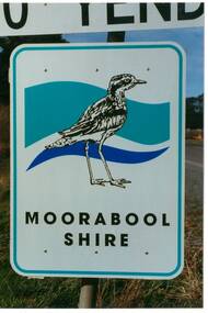 Buninyong & District Historical Society
Photograph - Original Photograph, Mr. C.J. Brooks, Moorabool Shire sign closeup, September 1995
Social, historicalExample of the Moorabool Shire sign in the late twentieth centuryColour photo, closeup of the Moorabool Shire sign on the Western outskirts of the township of Yendonroad signs, yendon, moorabool shire, streetscape -
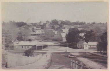 Clunes Museum
Photograph, UNKNOWN
BLACK AND WHITE PHOTOGRAPH OF CLUNES TOWNSHIP. TAKEN FROM CAMERON STREET HILL.local history, photography, photographs, clunes township -
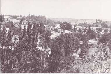 Clunes Museum
Photograph
COPY OF BLACK AND WHITE PHOTOGRAPH OF CLUNES TOWNSHIP, TAKEN FROM LUGG STREET.local history, photography, photographs, clunes township -
 Clunes Museum
Photograph, CIRCA 1880
AN ETCHING OF VERY EARLY CLUNES. TREE GUARDS AROUND TREES ALONG CREEK BANK, ORIGINAL NAMED TULLAROOP CREEK.CLUNES TOWNSHIP, CRESWICK CREEK, DOUBLE STORY BUILDINGS AND MINE POPPET HEADS.TOWN OF CLUNESlocal history, photography, photographs, clunes township. -
Whitehorse Historical Society Inc.
Document, Division of Survey and Mapping, 1984
Information guide to Parish and Township Plans - Division of Survey and Mapping - Victorian Government..Information guide to Parish and Township Plans - Division of Survey and Mapping - Victorian Government..Information guide to Parish and Township Plans - Division of Survey and Mapping - Victorian Government..crown lands, victorian government, land surveys -
 Stawell Historical Society Inc
Photograph, Open Cut Big Hill overlooking Stawell towards Grampians
Scotts Open Cut Big Hill c 1960 overlooking Stawell towards Grampians. The first quartz was mined for in the open cut from Fisher Street, to the Big Hill, below the Pioneers Memorial.Black and white photograph of an open cut on the side of a big hill. The township in the background.stawell mining -
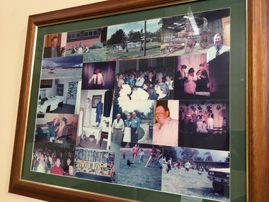 Pyrenees Shire Council
Photographs, Lexton 150th Celebrations (1 of 2), c1995
significant to the Pyrenees Shire and Lexton communityframed photo montage"Inscribed front: 150th Birthday Celebration Lexton Township 4-5 Nov 95" -
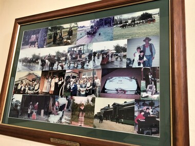 Pyrenees Shire Council
Photographs, Lexton 150th Celebrations (2 of 2), c1995
significant to the Pyrenees Shire and Lexton community"Inscribed front: 150th Birthday Celebration Lexton Township 4-5 Nov 95" -
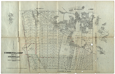 Federation University Historical Collection
Plan, Commeralghip, County of Grenville, 1905, 03/02/1905
The Township of Kaleno is in the Pitfield Plains. The Cape Clear Cemetery T contains the graves of miners and local pioneering families from the Cape Clear, Hollybush, Kaleno, Pitfield Plains, Pitfield, Illabarook, Berringa, Springdallah, Wallinduc, Glenfine, Happy Valley and Western Creek districts.Plan of allotments in Commeralghip, County of Grenville, Victoria. The plan includes the township of Kaleno, Dereel Pre-Emptice Right (John Cullen), Commeralghip Pre-Emptive Right (John Gordon McMillan and Glenfine Pre-Emptive Right (William Rowe). It also includes landholders such as Robert mcPherson, C. Cameron. John Boyd, John Cullen, W.T. Rowe, George Currie, J.P. Mackay, T. McCaffery, G. Hawkins, Alexander McPherson, C. Cameron. Gift of the Squire Family, 2014commeralghip, pitfield plains, kaleno, dereel, glenfine, squire, richard squire, w.t. rowe, john cullen, alexander mcpherson, george currie, mt misery, william rowe, mindai, john gordon mcmillan -
Clunes Museum
Photograph, CLUNES IN THE 1860'S
CRITERION. QUARTZ MINING COMPANY REGISTERED CLUNES VIEW IN TOWNSHIP, CLUNES, SOUTH EAST CAMP PARDE, CLUNES, SOUTH WEST PORT PHILLIP AND COLONIAL GOLD MINING COMPANY, CLUNES VICTORIAN QUARTZ MINING COMPANY, REGISTERED CLUNESCLUNES IN THE 1860S FIVE VIEWS BY CHARLES NETTLETON .1 LARGE ENVELOPE WITH DESCRIPTIONS OF EACH OF THE PHOTOS. PUBLISHED BY SHIRE OF TALBOT AND CLUNES FROM ORIGINAL PHOTOGRAPHS. .2 PHOTO PRINT - VIEW IN TOWNSHIP, CLUNES, SOUTH EAST .3 PHOTO PRINT - CAMP PARADE, CLUNES, SOUTH WEST .4 PHOTO PRINT - PORT PHILLIP AND COLONIAL GOLD MINING COMPANY, CLUNES .5 PHOTO PRINT - VICTORIA QUARTZ MINING COMPANY, REGISTERED, CLUNES .6 PHOTO PRINT - CRITERION QUARTZ MINING COMPANY, REGISTERED. CLUNESC. NETTLEFOLD, PHOTO, MELBOURNElocal history, photography, photographs, mining, clunes in the 1860's five views by charles nettlefold -
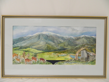 Kiewa Valley Historical Society
Painting, Cattlemen of the Bogong High Plains, c1995
Leo Wimmer who lived locally was commissioned to do the painting for the Mt Beauty, S. K. Pearce Pty. Ltd., Supermarket as a display was wanted to fit against the blank walls opposite the cash registers (where the liquor store is now). His idea was to break up the parts in the painting and use these as large replicas painted on wood for the display. An official opening was held and Leo used the money earned to visit his homeland, Austria. Leo trained as a restorer of church art in Austria.This painting was commissioned for a Cattlemen's display behind the cash registers at the Mt Beauty S. K. Pearce Supermarket. Each part of the foreground was painted separately onto stand alone boards -the cattle, the hut, the grass and the Mt Beauty township. Leo Wimmer lived locally and was a professional frame conservator. Leo Wimmer specialised in gilding and worked at the National Gallery of Victoria and later the National Gallery of Australia (NGA Nov. 1981 - 1990) where he was responsible for conservation of gilded frames in the national collection. This involved crafting of missing pieces on period frames, conservation/restoration of gilded surfaces, crafting of period frames, and lecturing at galleries and institutions on gilding, wood carving, Australian frame history and crafting of period frames. Framed painting of Mt Bogong with cattle, Mt Beauty township and cattleman's hut in foreground.Circular watermark (illegible) on bottom right corner. "Wimmer / 1" is underneath the watermark.cattlemen; bogong high plains; s.k.pearce; mt beauty supermarket; leo wimmer; -
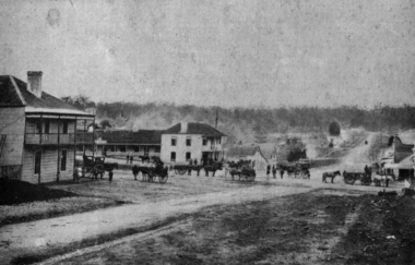 Federation University Historical Collection
Photograph - Image, Buninyong, 1859 - Looking North, 1859
Buninyong was Victoria's first inland town, and is in close proximity to Ballarat. The fledgling township of Buninyong. Early buildings line the streets, and horse drawn carriages are evident. buninyong -
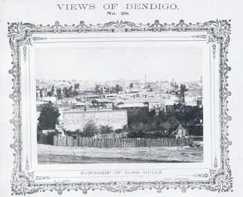 Bendigo Historical Society Inc.
Photograph - VIEWS OF BENDIGO: TOWNSHIP OF LONG GULLY, c. 1870's
Photograph No. 28: Sepia photograph of Township of Long Gully. (Two Copies) Nicholas CairN J Caireplace, landscape view, golden square -
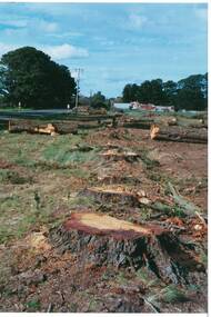 Buninyong & District Historical Society
Photograph - Original Photograph, Mr. C.J. Brooks, Main street of Yendon from the West showing felled pine trees and tree stumps, September 1995
Social, historicalExample of the felling of trees for power company in the late twentieth centuryColour photo, of the Western outskirts of the township of Yendon showing felled pine trees and stumps yendon, moorabool shire, streetscape, felled pinetrees, powercor -
Tatura Irrigation & Wartime Camps Museum
Folio, Murchison Memoirs. A Trevaskis, May, 1990
Family History of A. Trevaskis32 pages of recollections by A. Trevaskis of his Family and Murchison families and Township 187 - 01990My Memories of Murchison by Arthur Trevaskisdocuments, biography