Showing 2022 items
matching white m.
-
 Glenelg Shire Council Cultural Collection
Photograph - Photograph - Portland Lighthouse, M. E. Andrews, n.d
Black and white photo of the lighthouse, Portland, looking up hill, lighthouse behind fence, small shed between fence and lighthouseBack: 'Lighthouse, Portland' = handwritten, black ink. Round purple stamp: 'PRINTED BY M.E. ANDREWS, PORTLAND'portland harbour, lighthouse -
Glenelg Shire Council Cultural Collection
Photograph - Photograph - Portland Butter Factory, M. E. Andrews, n.d
The Portland Butter Factory opened in a new building 1935 on the Heywood Road. The opening of the building was attended by K. S. AndersonBlack and white photo of the Portland butter factory. Timber building, split level, large brick tapered chimneyBack: 'Butter Factory Portland' - handwritten in black ink Round purple stamp 'PRINTED BY M.E. ANDREWS PORTLAND'portland industry, dairy, trade -
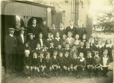
![Photograph - School Photograph (copy), Greensborough State School [Gr2062] 1921 Grades 5, 6, 7, 8, 1921](/media/collectors/4f729f5697f83e03086015b8/items/4fc06beb2162ef0df028cafc/item-media/629c57758e76c2eb35cdb636/item-fit-380x285.jpg) Greensborough Historical Society
Greensborough Historical SocietyPhotograph - School Photograph (copy), Greensborough State School [Gr2062] 1921 Grades 5, 6, 7, 8, 1921
Group photo of students at Greensborough State School 1921 in grades 5-8.Copy of early photograph from Greensborough Primary School. Significantly it has the names of all children recorded.Printed copy of black and white school photograph with typed caption naming students Jessie M Scholes (Partington)greensborough primary school, greensborough state school -
 Ararat & District Historical Society (operating the Langi Morgala Museum)
Photograph, 1920s
This appears to be a photo of all or most of the Pupils and Staff of Ararat Church of England School, ca1920s. The names of all or most are written on the back of the photo.This is an early photo of the Ararat Church of England School. The date, and the names attached to or written on the back of the photo add to the signficance of the photo, making it of local significance.Black and white photograph mounted on cardboard. The photograph shows a group of 39 students in four rows and a man and woman standing to their left. They are in front of a brick building.Inscription: on back, both written in ink, and repeated on an affixed cardboard label. Church of England Grammar School 1920's./ Back row left to right L. Wright, H. Banfield, T. Butt, N. Gamson, R. Hodgetts,/ T. Webb, Mr T. C. Cochrane, Miss K. Webb, First row M. Webb, L. Robertson,/ J. McKay, T. Brown, E. Brown, B. Edwards, D. Hayman, I. Edwards/ Second Row - G. Foster, J.H. Webb, B. Hayman, E. Noltenius, Temple/ B. Richardson, I. Gibletr/ Front Row: F. Ramage, W. Owen, J. Dunn, J. Foster/ M. Hayman, L. Ford, B. Nolteniuseducation, 1920, school, teacher, church-of-england, pupil, ararat-church-of-england-school, ararat-school, ararat-education -
 Eltham District Historical Society Inc
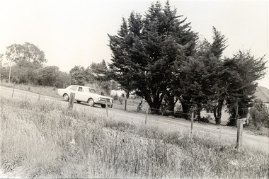
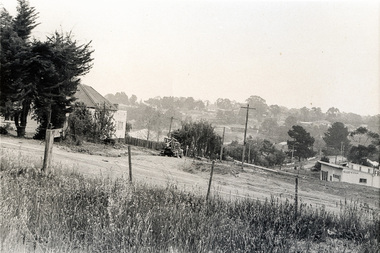
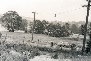
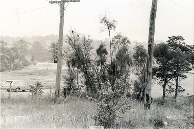
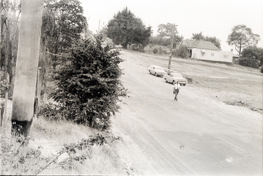
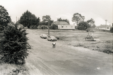
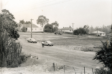
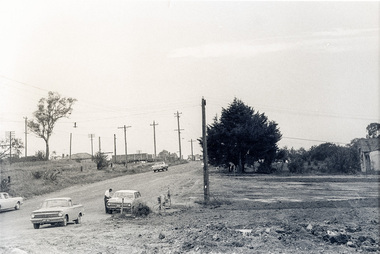
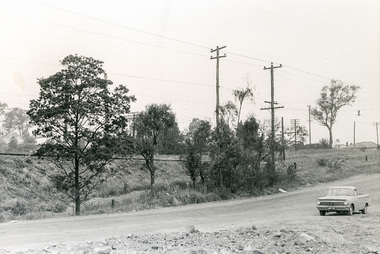
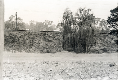
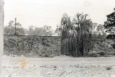
Photograph, Sherbourne Road, Para Road and Simms Road at Briar Hill/Montmorency prior to the upgrade of Sherbourne Road Railway bridge, c.1970
Collection of photographs probably taken around the same time depicting Sherbourne Road, Para Road and Simms Road at Briar Hill/Montmorency prior to the upgrade of Sherbourne Road Railway bridge, c.1970. Photo 01648_ 19 This home owned by Mrs Cameron. Her daughter married a Mr Davey, for whom Davey Road was named - email from M. Jones 20/07/2015 Photographer unknownThese photos are very significant in the documentation of the development of the Briar Hill and Montmorency areas and the changes in the physical landscape along the railway line area.20 black and white prints 9 cm x 13 cm.1970, briar hill, davey road, montmorency, para road, cameron, davey, sherbourne road, simms road, railway line, roadworks -
 Eltham District Historical Society Inc
Photograph, Sherbourne Road, Para Road and Simms Road at Briar Hill/Montmorency prior to the upgrade of Sherbourne Road Railway bridge, c.1970
Collection of photographs probably taken around the same time depicting Sherbourne Road, Para Road and Simms Road at Briar Hill/Montmorency prior to the upgrade of Sherbourne Road Railway bridge, c.1970. Photo 01648_ 19 This home owned by Mrs Cameron. Her daughter married a Mr Davey, for whom Davey Road was named - email from M. Jones 20/07/2015 Photographer unknownThese photos are very significant in the documentation of the development of the Briar Hill and Montmorency areas and the changes in the physical landscape along the railway line area.20 black and white prints 9 cm x 13 cm.1970, briar hill, davey road, montmorency, para road, cameron, davey, sherbourne road, simms road, railway line, roadworks -
 Kiewa Valley Historical Society
Postcard Circa 1950, Lake Guy Dam and Bogong Village, Circa 1950
This postcard was produced in the 1950's for the tourist trade in the Kiewa Valley and Alpine region. It encompasses the period when the State of Victoria was pressured by the ever increasing demand by industry and its population for electricity supplies. Hydro electricity was seen as an untapped natural resource to quench this demand. The Victorian Alps and the rivers flowing into its valleys was ideal for the construction of the Kiewa Hydro Electricity Scheme. The late 1940's saw the development of this scheme and the changing of sections of alpine landscape is covered by this and other postcards/pictures (tourists, construction workers, and established rural populations). This period in time was before the established wildlife and forest/nature groups became political activist who changed legislative acts to protect the environment.This rural region (Kiewa Valley/alpine plains) was at most only significant to a smaller group of winter sports, summer hikers/horse riders and rural farmers/graziers. The numbers of tourists and the increase in the local resident population was boosted by the construction of the Hydro Electricity Scheme. This influx to the regional population resulted in a corresponding diversity in services and brought about an environment that responded to a growing level of tourists and thereby permitting this industry to grow more rapidly than it would have naturally. This postcard details an attraction to the "cleaner" method of providing electricity. This postcard was purchased in 1950 by a surveyor at Landford's Gap.This black and white photograph from a Valentine's postcard is from a V2 Argus photograph postcard. It is on a 200g/m paper density photo side gloss. See 0480 (B) - (F) for other photos of similar postcards.In white lettering " LAKE GUY & BOGONG VILLAGE KIEWA HYDRO-ELECTRIC PROJECT"kiewa valley tourism, victorian alps, alternate energy supplies, alpine population growth -
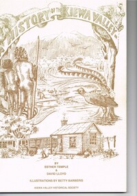 Kiewa Valley Historical Society
Book - A History of the Kiewa Valley, Kiewa Valley Historical Society, A History of the Kiewa Valley by Esther Temple and David Lloyd, Circa 1991
This book was compiled by Esther Temple and David Lloyd with illustrations by Betty Barberis and additional material provided by Clare Roper, Joan Macdonald, Wilma Davies and Nell Bateman. The book was first penned in 1971. It briefly covers the period from the indigenous tribes(broken down into family groupings) known as the "first Australians" who lived in the valley well before English settlers arrived. first white settlement (graziers, miners, stockmen) to smaller settlements.The development or transformation from a pristine(hunter/gatherer) valley environment to one that has been gradually changing to a more commercial rural/industrial landscaped valley. This transformation was made within a time span of two hundred years. The book details the first pioneers and their descendants, along with the changes to their environments both domestic and commercial. The book highlights dates and events that shaped the "feel" of the valley. The extreme hardships faced by pioneer families during the extremely isolated times away from "civilisation".This publication provides an insight to the struggles and victories against the harsh Australian bushland by people who had not been raised in such a sometimes inhospitable environment. It was this transformation which instilled into the Australian psyche of self sufficiency and the ability to grasp onto ideas or "bush" remedies to overcome enormous difficulties. It is is ability that has produced the many inventions useful in the 20th and 21st centuries.This book has a 250 g/m cream coloured cover with print and drawings of rural aspects of historical significance ( Aboriginal and early white settlers). The book contains 124 pages of black and white photographs(139), black and white sketches(75), two pages of sketches and freehand drawings, two freehand maps one county lease /subdivision plan and black and white printing. See KVHS 0237 (B) for the official invitation to the launch of the book.The front top cover heading(in shaded print and enclosed in a banner form) "A HISTORY OF THE KIEWA VALLEY" The bottom printing "BY ESTHER TEMPLE & DAVID LLOYD ILLUSTRATIONS BY BETTY BARBERIS" and at the very bottom "KIEWA VALLEY HISTORICAL SOCIETY" oN THE BOOK SPINE "A HISTORY OF THE KIEWA VALLEY.....BY ESTHER TEMPLE & DAVID LLOYD"early settlers, dederang, tawonga, mount beauty, sec vic hydro electricity, falls creek early settlers, bonegilla -
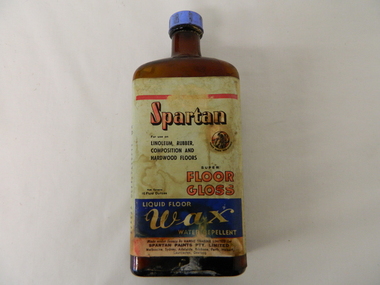 Kiewa Valley Historical Society
Bottle - Liquid Wax, mid 1900's
This bottle of liquid floor polish was manufactured before 1960(taken over by Wattyl) in a period when most of the floors in high traffic areas were covered in linoleum. Most of the floors using this product during this period would have been kitchens and laundries. During this period the cleanliness of the kitchen, hallways and eateries had to appear clean (cleanliness was a sign of a bacteria free area). This was a priority for kitchens, mess areas(SEC Hydro Scheme facilities) and connecting walkways. The cleanliness attitude was enhanced in the rural areas due to the "dirty" farm work not impinging upon the residential home.When Mount Beauty was first inhabited all the residential and worker's facilities were a prime area for linoleum floor surfaces. The liquid floor polish was in great demand, "a polished floor is a clean floor".This bottle of liquid floor polish is very significant to the Kiewa Valley, not only that it covers the floors of every home and residential barracks of the first major development of a "town" now known as Mount Beauty but also it demonstrates that the "cleanliness" approach of early Australians living areas in the rural regions was "on par" with its city cousins. It is the smaller types of mores that underlie the "mushrooming" cultural and psyche "wholeness" of an ever expanding Australian culture.This brown opaque glass bottle with an oblong shape has a blue coloured "screw on" cap. It has a "wrap around" label glued firmly on the bottle and covers the front and sides.On the front main label under a red line, "SPARTAN" underneath in smaller print "For use on" below this, "LINOLEUM, RUBBER, COMPOSITION AND HARDWOOD FLOORS" besides this is an encircled Trade Mark of a "Spartan Warrior holding a spear and shield" these word follow the curviture of the circle and are below it "TRADE MARK REGISTERED" Below this are "SUPER FLOOR GLOSS" to the left in very small print "Nett Contents 16 Fluid Ounces". Below this on a blue background and in white print"LIQUID FLOOR WAX WATER REPELLENT". On the bottom of the label "Made under licence by HARDIE TRADING LIMITED for SPARTAN PAINTS PTY, LIMITED" below this in small print "Melbourne, Sydney, Adelaide, Brisbane, Perth, Hobart, Launceston, Geelong. Embossed on the bootm of the glass is" G/Mfloor cleaners, liquid polish, "hygienic" clean floors. -
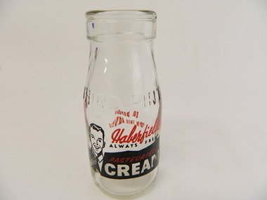 Kiewa Valley Historical Society
Bottle - Cream, Pre 1966
Cream was stored and sold in bottles and bought at a local store. History of Haberfield's. The measurement of liquids was in pints and money in pence (d) pre 1966. Bottles were returned to the manufacturer who reused the bottle. To encourage the return of bottles, collectors were given 3d (pence) per bottle. Historical: Dairy farmers living in the Kiewa Valley, sent their milk to be separated into cream by a Dairy company and then sold to the public. Aesthetic: Display showing variations of shape, embossing and stencillingSmall clear glass bottle containing one third of a pint and used to carry cream. it tapers to a lip at the neck. On one side and the base it is heavily embossed. Under the embossing on the side it is stencilled in red and black words and outline of a picture of a happy man wearing a tie pointing to the writing.Base: Common Seal with 'A' and 'G' and 'M' inside the 'A'. under which is '91/6' under which is' ISM - 707' Side: embossed: Third Pint Side: stencilled: Haberfield's (red) / always red (black) / Pasteurised (red on black) / Cream (white on black) Opposite side: stencilled: 3d Deposit / On This Bottle (all in red)dairy, farmers, haberfield's, cream -
 Kiewa Valley Historical Society
Jar - Ointment - Medical
This jar was used in the Tawonga District General Hospital which was built in the 11950's specifically for the increase in population due to the Kiewa Hydro Scheme.Small wide white 'milk glass' jar with screw top. Used for ointment e.g.. zinc, magnesium sulphate. Embossed on base. Base is 'pushed inwards/upwards' forming a lip around the circumference.Base: Common Seal - A with G above and M below / 15 medical, hospital, ointment -
 Kiewa Valley Historical Society
Ron White's Collection - 1920 - 2019
Ron White was born in 1920. He received a Diploma of Mechanical Engineering at Footscray Technical School in 1946. He started work as a laboratory assistant and after several promotions was appointed Senior Operator in 1948. In 1949, he was Engineer, Grade 1 (Hydro Areas). After further promotions he became Assistant Area Engineer, Rubicon at new Eildon Power Station and Area Engineer, Kiewa in commissioning Mt Beauty Terminal Station and West Kiewa Power Station.. By 1956, he was the Area Operations Engineer at Kiewa and four years later the Kiewa Electrical Superintendent (Operations and Maintenance) . In 1961, he was officially recognised as deputy for the General Superintendent, Kiewa. In 1966 he was appointed General Superintendent Kiewa and Kiewa became 'a branch of the Transmission Department'. In 1974, the Rubicon / Eildon Area was also under Ron's control. His title was "Principal Hydro Engineer, Hydro Division, Transmission Operations Department. He held this position until his retirement in 1985.Ron White was an important identity in his role as Principal Hydro Engineer from 1966 to 1985 after the completion of the Kiewa Hydro Electric Scheme. His long period of service involved him in the construction, operation and maintenance of the SECV's Hydro Electric Schemes and administration of related catchment areas. He had a close association with the local communities and care for the welfare of employees. He lived in Mt Beauty and was well respected in the community and beyond. He passed away on 30 September 2019, aged 99 years.A) History of Ron White's Working Life: including papers relating to "Promotion & Staff Appointment" B) Ron White's Retirement - 11th Jan. 1985: papers, cards, letters, photos, disc/plaque C) Ron White's Certificates: Diploma of Mechanical Engineering; First Aid; D) Ron White's Correspondence - miscellaneous E) Ron White's History of the 'Kiewa Scheme' from 1936- 1966. Written 1986 F) Ron White's Photo album Includes photos of him and the 2003 bushfires G) Miscellaneous Photos (not labelled) from Ron's photo album. Possibly relatives including nieces and nephews. H) Pewter Mug presented to Ron - Water Board I) Wall hanging presented to Ron - Scouts J) Ron White's Slide Ruler & Mathematical Instruments K) Collection of 7 books owned by Ron L) Starting Pistol Caps box M) Ice-cream serverF) One photo of Ron with 'Ken Connors'. One photo with 'l to r: Norm Middleton, Graham Napier, Ron White, Les Peart.' G) 2003 fires has a note re time, date and whereabouts of fires H) "Presented To / Ron White / In Appreciation For Service / To The / Kiewa Valley / Water Authority / And / Its predecessor Bodies / December 1994 I) Wall hanging: On emblem - "Lord Baden-Powell Society / The Scout Association of Australia". On Name Plate below - Ronald K. White 1989" J) mathematical Instruments have 'R. W' embossed in red on the corner of the cover M) 100 Straitline, Starting Pistol Caps N) National Ice-cream Server with stainless steel spring Size 20 ron white, hydro engineer, kiewa hydro electric scheme -
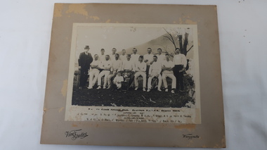 Kiewa Valley Historical Society
Photo - Running Creek Cricket Club
This is a photo of the Running Creek Cricket Club, Premiers. U. K. V. C.A. (Upper Kiewa Valley Cricket Association) Season 1913-1914.Names which are legible are: Back Row: ? , N/M Hynes, F. Seymour, C. Grealey, W. Barton, F. Briggs, A. B. Seymour, H. Grealey. Front row: W.H. Hobbs, D. Black, C. Woolley, J. Fahey (captain), M. Hobbs, J. Black, Ibb Hobbs.Running Creek is in the Upper Kiewa Valley where sporting and recreational activities were an important part of rural social life. A mounted photo on cardboard with the names of the Running Creek Cricket team printed (almost illegible) under the photo of 15 men - 13 cricketers in white, 2 men one at each end and a boy and the premiers cup at the front. 1913-1914Vine's Studios / Wangarattarunning creek, upper kiewa valley cricket association