Showing 199821 items matching "12-errard-street-south"
-
 Federation University Historical Collection
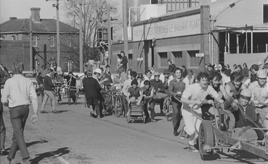
Photograph, Ballarat School of Mines Centenary Tricycle Race, 1970, 08/1970
The Tricycle Race / Push started outside the Ballarat School of Mines in Lydiard Street South and ended at the Russell Park Terminus at Burrumbeet. Numerous males students push tricycles of all descriptions outside the Ballarat School of Mines and Ballarat Brewery in Lydiard Street South. Four photographs show students being pushed along the road. ballarat school of mines, ballarat brewery, lydiard street south, centenary, ballarat school of mines centenary, anniversary, tricycle race, student activity, procession, cyclist -
 Whitehorse Historical Society Inc.
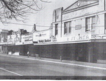
Photograph - Strip photo and photocopy, Blackburn shops in South Parade Blackburn, 1/08/1976 12:00:00 AM
B/W strip photo of South Parade and Gardenia Street Blackburn.blackburn, shops -
 Ballarat Heritage Services
Photograph - Photograph - Colour, W Track, White Flat, Ballarat, 2016, 25/10/2016
Photographs of W-track on South Street, between Hickman Street and Armstrong Street South, Ballarat.white flat, w-track, south street, ballarat -
 Greensborough Historical Society
School Photograph - Digital Image, Watsonia High School WaHIGH 1987 Year 12 VCE, 1987_
A photograph of Watsonia High School 1987 Year 12 VCEA photograph of Watsonia High School 1987 Year 12 VCEwatsonia high school -
 Federation University Historical Collection
Print, Ballarat School of MInes, Lydiard Street South, 1919
Image of the Ballarat School of MInes Lydiard Street buildings.ballarat school of mines, a building, administration building, ballarat technical art school, lydiard street south -
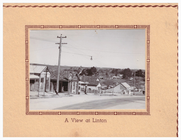
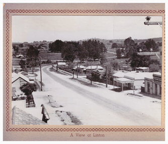 Linton and District Historical Society Inc
Postcard, A View at Linton, Sussex Street, Linton, view to south, circa 1940
The "Lorna, Bob and Elsie" in the inscription are probably Elsie McCorkell, her son Robert Hayward, and her daughter Lorna McCorkell.A very small photograph which has been made into a souvenir/postcard. The photograph is a view of Sussex Street, Linton, looking south-west. On the right of the photo are Ching's store, R. N. Sandow confectionery shop, a house next to it, and the first Bank of NSW building. Two houses are further down the road past Gillespie Street. On the left of the photo are the Edinburgh Bakery and a store with a verandah on the corner of Gillespie Street. The photograph is glued to a beige-coloured card which has a decorative edge cut into it. A printed border surrounds the photograph, and the words "A View at Linton" are printed underneath it. The card appears to have had the right-hand edge trimmed with scissors. Because of this, an inscription on the back of the card has been partially cut away. The inscription reads "-rs Whitehand & Doris / -with love from Lorna, Bob and Elsie".sussex street linton, buildings, shops, houses, sandow shop, ching's store, edinburgh bakery, postcards, souvenirs, lorna mccorkell, robert hayward, elsie mccorkell -
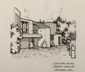 Kew Historical Society Inc
Drawing - Property Illustration, Margaret Picken, 5/12-14 Park Crescent, Kew, 1996
After training as a Cartographic Draftsman within the mining industry, I worked as a property illustrator for real estate firms in the eastern suburbs of Melbourne for 23 years from 1983. I initially photographed houses with a Polaroid camera and made a 'thumbnail' sketch while there. The photos were used to scale off a sketch in pencil and then that sketch was overlaid with drafting film and the 'pen and ink' completed. The pens I used were the Rotring ‘Rapidigraph’ drafting pens. The ink was also made by Rotring (German).The film was ‘Rapidraw’, polyester drafting film, double matte. It takes a very fine line and doesn’t bleed. As well as house sketches, there were often floor plans and site plans ordered. Aerial sketches were ordered when the property needed an overall view. (Margaret Picken, 2020)This drawing is one of a series created by Margaret Picken for a number of real estate agents in Melbourne between 1983 and 2005. Each work is signed and dated by the artist.Gift of Margaret Picken, 2020Pen and ink architectural drawing on drafting film of 5/12-14 Park Crescent, Kew by Margaret Picken.5/12-14 PARK CRES., KEW / MARGARET PICKEN '96 / WOODARDS ~ HAWartist -- margaret picken 1950-, architectural drawings -- houses -- kew (vic.), 5/12-14 park crescent - kew (vic) -
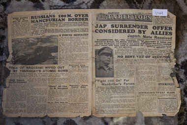 Lara RSL Sub Branch
Newspaper - Table Tops Newspaper Dated 12/8/1945, 1st Australian Press Unit, A.I.F. Table Tops Newspaper dated 12/8/1945 - Jap Surrender Offer Considered By Allies
1st Australian Press Unit, A.I.F. Newspaper Table Tops Dated 12/8/1945 Australian Forces Produced Newspaper dated 12/8/1945Table Tops Newspaper Dated 12/8/1945 Jap Surrender Offer Considered By Allies - Fight Still On for MacArthur's Forces - Nagasaki Wiped Out By Thursday's Atomic Bombjap surrender offer considered by allies - fight still on for macarthur's forces - nagasaki wiped out by thursday's atomic bomb, table tops newspaper dated 12/8/1945, world war 2 -
Bialik College
Mixed media - Soft mounted enlarged Year 12 group photographs for 2018; 2019
Year 12 group photographs for 2018; 2019Soft mounted enlarged Year 12 group photographs for 2018; 2019bialik college, 2018, 2019, year 12 -
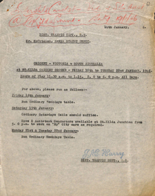 Melbourne Tram Museum
Document - Memorandum, Melbourne & Metropolitan Tramways Board (MMTB), Cricket - Victoria v South Australia at St Kilda Cricket Ground, 14/01/1946 12:00:00 AM
Cricket - Victoria v South Australia at St Kilda Cricket Ground Friday 18th to Tuesday 22 January 1946 Memorandum - four typed sheets - titled "Cricket - Victoria v South Australia at St Kilda Cricket Ground" from District Traffic Superintendent S.S. to Mr McCutchan, Hanna Street Depot, Mr Mazoletti, Malvern Depot, Mr Cliff, Glenhuntly Depot, Mr Taylor, Port Melbourne. Memo dated 14 January and specifies trams, buses and inspector positions required for event."Interstate Cricket - Vic v South Aust @ St Kilda Ground - Saty 19/1/46" written in black pencil on both copies.trams, tramways, instructions, events, specials, cricket -
 Greensborough Historical Society
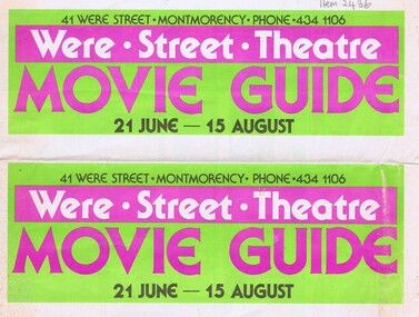
Program, Were Street Theatre, Were Street Theatre Movie guide, 21/06/1979
Movie Guide for the Were Street Theatre, 21 June - 15 August [year not specified, c1979].Double-sided program printed in colourwere street movie theatre, were street -
4th/19th Prince of Wales's Light Horse Regiment Unit History Room
Leaflet, The Army Museum of New South Wales, The British Regiments in Australasia
An information leaflet from the Army Museum of New South Wales listing all the British Regiments that served in Australasia from 1788 to 1913british regiments, australia -
Bialik College
Film (Item) - Year 12 Media Studies performances, 2004, 2004 Year 12 Media Studies
Recordings of Year 12 media studies performances, 2004. Please contact [email protected] to request access to this record. Year 12 2004 media studies 2000s, assessment, performing arts -
 Greensborough Historical Society
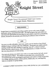
Pamphlet, Knight Street Occasional Child Care Centre Inc, Knight Street, 2006
A pamphlet outlining services available at Knight Street Occasional Child Care Centre, later named Watsonia Occasional Child Care.4 page pamphlet, printed on light green paper.watsonia occasional child care., knight street occasional child care centre -
 Melbourne Tram Museum
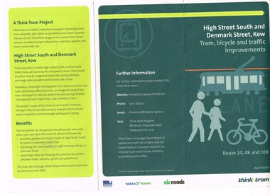
Pamphlet, Yarra Trams, "High Street South and Denmark St, Kew - tram, bicycle and traffic improvements", 2009
Set of two pamphlets issued to advise passengers of tramway works and improvements during 2009. .1 - "High Street South and Denmark St, Kew - tram, bicycle and traffic improvements" - introduction of tram lanes and no right hand turns - April 2009 .2 - "Tram Improvement works Routes 48, 70, 109 and 112" - construction of curves from Wellington and Flinders St into Spring St and from Spring St into Collins St and other changes - May - July 2009trams, tramways, high st kew, collins st, spring st, city circle, route 48, route 70, route 109, route 112, route 24, construction -
 Federation University Historical Collection
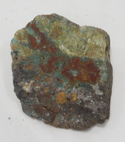
Rocks, Azurite and Malachite Specimens, Moonta, South Australia
From the Ballarat School of Mines.Azurite and Malachite Specimens (and iron), Moonta, South Australiageology, rock, azurite, malachite, moonta -
 Federation University Historical Collection
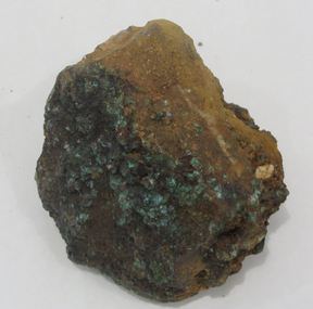
Geological specimen - Rocks, Copper Specimen, Broken Hill, New South Wales
From the Ballarat School of Mines.Copper Specimen, Broken Hill, New South Walesrocks, geology, copper, broken hill -
 Eltham District Historical Society Inc
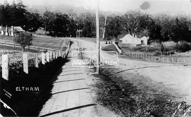
Negative - Photograph, J.H. Clark, Main Road, Eltham, south from Brougham Street to Dalton Street, c.1911
Main Road, Eltham, south from Brougham Street to Dalton Street, c.1911 View looking down Policeman’s Hill on Maria Street (Main Road) from near Brougham Street towards Dalton Street, site of the Avenue of Honour established in 1916-1917 in memory of the soldiers who served in the First World War, 1914-1918. At the bottom of the hill on the right is White Cloud Cottage, home of the Jarrold family, three women standing out front observing the photographer. The road passes over a culvert which runs to the west in front of the cottage. The cottage was originally located closer to the Diamond Creek but was subject to flooding. It was dragged by horse to the present site shown, which was chosen for the higher ground that had been created as a result of land fill being deposited here from the quarry further around the bend on Main Road (site of present-day Eltham Primary School carpark) where the stone had been quarried for building the State School in Dalton Street. Immediately at the end of the straight section of the main road can be seen the gas streetlamp in front of the Jarrold home and the pond at the bottom of Dalton Street. The cottage had previously been rented for use as a Police Station / residence prior to the building of the permanent police house and station at the corner of Maria and Brougham streets in 1859. At the time of collection of photos for the centenary of the Shire of Eltham (1971) the cottage was owned by the Skipper family and remains in the family to present day (2021). On the left is the Grant house on the corner of Main Road and Dalton Street now the present-day site of Eltham Clinic. Cross Ref: 0749 for another view of the Jarrold family home Photographer: J.H. Clark John Henry Clark was the youngest of three boys born to William Henry Clark (1823-1877) and Maria White (1843-1914). He and his brothers, William Charles Clark (1872-1945), Clement Kent Clark (1874-1912) operated a photography business (Clark Bros.) from 25 Thomas Street, Windsor near Prahran during the period c.1894 to 1914. Following death of Clement in September 1912 and their mother in 1914, the Clark Bros business appears to have dissolved, the premises demolished, and a new house was under construction in 1915. John set up business independently in 1914 operating out of 29 Moor Street, Fitzroy where he is registered in the 1914 and 1915 Electoral Rolls. By 1916 John had relocated to Eltham where he continued his practice as a photographer and took many of the early images around the district of Little Eltham. Around 1930 John changed professions and opened a small cobbler's shop in 1931 near the pond opposite Dalton Street adjacent to the Jarrold family cottage. He never married and continued his profession as a bootmaker from this little shop, maintaining a close relationship with Mrs Jarrold for the rest of their lives. His bootmaker shop remains today beside the Whitecloud cottage and is one of only three remaining shops in the area from the early 20th century. There are a couple of images of Eltham taken by Clark Bros. in the Eltham District Historical Society collection, one such example being Hunniford’s Post Office with Miss Anne Hunniford out front (EDHS_00140 - marked on the back of the print, Clark Bros., 25 Thomas St. Windsor), which would date this image between c.1894 and 1914. Other early images of Eltham taken by John Henry Clark are marked on the face “J. H. Clark Photo” and it is assumed these are dated between 1914 and 1930. It is noted that the Grant of Probate for John H Clark of Eltham South dated 5 April !957 (513/387) records his occupation as "X Photographer".This photo forms part of a collection of photographs gathered by the Shire of Eltham for their centenary project book,"Pioneers and Painters: 100 years of the Shire of Eltham" by Alan Marshall (1971). The collection of over 500 images is held in partnership between Eltham District Historical Society and Yarra Plenty Regional Library (Eltham Library) and is now formally known as the 'The Shire of Eltham Pioneers Photograph Collection.' It is significant in being the first community sourced collection representing the places and people of the Shire's first one hundred years.Digital image 4 x 5 inch B&W Negshire of eltham pioneers photograph collection, eltham, main road, jarrold family, dalton street, j.h. clark photo, white cloud cottage, avenue of honour, eltham clinic, gas lamp, grant house, jarrold cottage, 1900 -
 Federation University Historical Collection
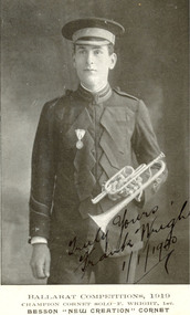
Photograph - Postcard, Ballarat South Street Competitions Cornet Champion Frank Wright, 1919, 1919
Frank Wright was a renown resident of Smeaton, where he was born. He lived at Laura Villa, and attended Smeaton State School. His father William was a gold miner and his mother's name was Sarah. Their family won many singing and instrumental awards. Frank was tutored by Percy Code and became the Australian Open Cornet Champion by the age of eighteen. A year later, Frank conducted the City of Ballarat Band, and later the Ballarat Soldiers’ Memorial Band. He formed the Frank Wright Frisco Band and Frank Wright and his Coliseum Orchestra. These bands won many South Street awards, and Frank as conductor won many awards in the Australian Band Championship contest. In 1933 Frank Wright sailed to England to conduct the famous St Hilda’s Band and was later appointed Musical Director of the London County Council, where he organized many amazing concerts in parks, in and around the London district. He was made Professor of Brass and Military Band Scoring and conducted at the Guildhall of Music and Drama. Frank was often invited to adjudicate Brass Band Championships around Europe, in Australia, including South Street and in New Zealand. The Frank Wright Medal at the Royal South Street competition is awarded to an individual recognized as making an outstanding contribution to brass music in AustraliaA black and white photograph of a cornet player depicted in uniform. He wears a medal and holds a cornet. The person depicted is Frank Wright who was the winner of the Champion Cornet Solo at the Ballarat CompetionsPersonal marking "Truly Yours Frank Wright 1/1/1920". Enscription - Ballarat Competitions, 1919, Champion Cornet solo-F.Wright, 1st, Besson"New Creation" Cornetcornet player, frank wright, ballarat competitions, south street competitions -
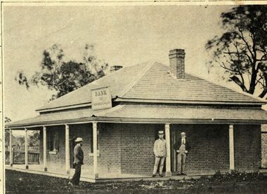
 Linton and District Historical Society Inc
Photograph, Martin Photo 72 Webster St, Ballarat, Bank of New South Wales building, Linton : side view of residence
Built in 1903-04, the "new" Bank of New South Wales at the northern end of Sussex Street replaced the first Bank of New South Wales building at the southern end of town.Photograph showing side view of residence and bank building of the "new '"Bank of New South Wales, completed 1904.."A view of the bank house of NSW Esther Cluff Linton". bank of new south wales, buildings -
![Journal series, Fleet Street patent law reports, [1968]](/media/collectors/54a9bcce2162f11b1cc120f2/items/54ebf4f02162f10f9cbf4e79/item-media/54ebf6b42162f10f9cbf6c0f/item-fit-380x285.jpg) RMIT GSBL Justice Smith Collection
RMIT GSBL Justice Smith CollectionJournal series, Fleet Street patent law reports, [1968]
Previous owner: J. McL. EmmersonNo. of volumes: 47 Volume range: 1967-1974 (large) & Vol. 1 (1975) - Vol. 40 (2013) Later title: Fleet street reports of industrial property cases from the Commonwealth and Europe Editors: Lunzer, R. ([1967] - 1969) Haywood, R. (1969 - 1972) Fysh, M. (1973 - 1994) Vitoria, M. (1995 - 2011) Clark, F. (2012 - 2013)industrial property -- europe -- cases, industrial property -- great britain -- cases, patent laws and legislation -- great britain -- cases, patent laws and legislation -- europe -- cases -
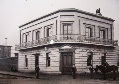 Glenelg Shire Council Cultural Collection
Photograph - Photograph - Commercial Bank, Portland, n.d
From original in State Library of South Australia.Black and white photographic copy of earlier image. View of a bluestone building on a corner of an unpaved street. Building has two stories, a wrought iron balcony and front door set in the corner with framing columns and pediment. Three men stand in front, with another mounted on a horse.Back: B21766/103 (pencil, upper left). Bank/History House (typed on white label, top centre). State Library of South Australia Photographic Section Reproduction prohibited except with the permission of the copyright holder. Order No A16493 (stamp).commercial bank, portland, bluestone building, commerce -
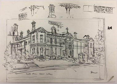 Kew Historical Society Inc
Work on paper, Joy Stewart, South Wing, Xavier College, c. 1978
Sydney Joy (joy) Stewart (1925-2018) was a founding member of the Kew Historical Society, and during the 1970s its secretary. During her residence in Kew, she completed numerous property illustrations on commission. These ranged from preliminary sketches, including architectural details to finished pen & ink and wash illustrations on paper. On moving to Queensland, Joy Stewart donated the remaining property illustrations in her possession to the Kew Historical Society. In 1987-88, she fulfilled a commission by the Society of designs for a series of embroideries completed by residents during the Australian Bicentennial commemorations. Sydney Joy (Joy) Stewart was born in Melbourne 1925. She studied at Swinburne Technical College Art School from 1941-1945, then the National Gallery Art School 1946-1948. Her career included employment positions as a display artist, designer/painter, gallery assistant, and art teacher. Joy relocated to Cairns in 1981. Solo exhibitions in Melbourne and Cairns, including 'Done By Me' at Cairns Regional Gallery in 1999. Group exhibitions at Cairns Regional Gallery, 'The Fish John West Regrets, 1993' and 'Facets of Life' 1994. Joy Stewart died in Cairns in 2018.Pencil, pen & Ink sketch on paper of 'South Wing, Xavier College' by the artist Joy Stewart. Inscription: "South Wing, Xavier College". Signed lower right: "JStewart".joy stewart, xavier college (kew) -
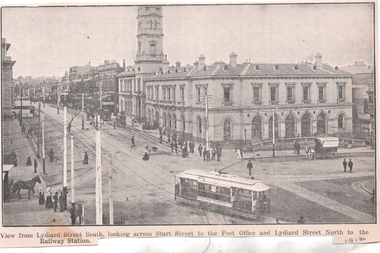 Ballarat Tramway Museum
Photograph - Illustration, WTP, "View from Lydiard Street South looking across Sturt St", c1907
Illustration of the intersection of Sturt St and Lydiard St Nth with the Ballarat Post Office being the primary feature. Has an ESCo tram turning from Sturt St into Lydiard St. Shows the trackwork at this location and has several horse-drawn vehicles in the photograph. Note the building in the road space on the left-hand side of the photograph. The caption along the bottom edge "View from Lydiard Street South looking across Sturt Street to the Post Office and Lydiard Street North to the Railway Station. On the rear has an item about Ballarat itself and its history. See also item 6245 for a postcard of this view. Yields information about the post office corner at the time of the opening of the tramway and demonstrates printing techniques.Black and white Illustration cut from a journaltramways, trams, sturt st, esco, post office, lydiard st north -
 Ringwood and District Historical Society
Photograph, Looking south from Bond Street Ringwood, across new market site. Clock tower right centre. Ringwood 1982
Written on back of photograph, "8/1/82. Looking south from Bond St. across new market. Clock tower right centre." -
Tatura Irrigation & Wartime Camps Museum
Book, Olympic Games -1956, October 1956
Information and schedule regarding the 1956 Melbourne Olympic GamesAs for historical informationSoft cover- cream with Olympic motif and Australian coat of arms in colour on front. Also has Melbourne 1956 and Bank of new South Wales on front. A Mitchellolympic games -
 Linton and District Historical Society Inc
Postcard, A View at Linton, Sussex Street, Linton, view to south-east, circa 1940
A very small photograph which has been made into a souvenir/postcard. The photograph is a view of Sussex Street, Linton, looking to the south-east. Buildings which can be seen in the photograph include Bennett's garage/service station, the Bennett family home, and the Edinburgh Bakery. The photograph is glued to a cream-coloured card which has a decorative edge cut into it. A printed border surrounds the photograph, and the words "A View at Linton" are printed underneath it. The card appears to have had the left-hand edge trimmed with scissors.sussex street linton, buildings, shops, houses, bennett's garage, bennett family home, edinburgh bakery, postcards, souvenirs -
 Wodonga & District Historical Society Inc
Photograph - Bank of New South Wales, Wodonga
The first Bank of New South Wales building in Wodonga was located in a small cottage. The branch opened on 7 May 1872. At first it was conducted as an agency of the Beechworth branch. In October 1872 premises in Sydney road were purchased from Mr P. L. M. S. Chauncy for £650. When the bank commenced in the cottage the first account was opened in the name of Hillerman & Co, storekeepers, Wodonga. Another early account was in the name of William Huon, squatter of de Kerilleau, Wodonga. On 9 July 1873, the agency was converted into full branch under the management of Mr. Joseph Belcher. Other early accounts included Cronin & Callaghan, storekeepers; John Bassett Jnr, shoemaker; John Jennings, contractor; Ah Soon, tobacco grower, Kergunyah; John de Corney Ireland, collector of customs; Andrew Kyle, fellmonger; Rowan Lockhead, accountant; Alexander McKay, publican; George Pollard, farmer; Thomas Street, farmer; and Edmund Uren, gentleman, Buninyong. Organisations banking at the branch included Wodonga Building Society, 1873; Wodonga Mechanics Institute 1875; Wodonga Band Fund 1882; Talgarno Athenaeum, 1888; Talgarno Butter & Cheese Factory 1892; Wodonga Federation League 1893; Wodonga Brass Band 1895; Wodonga Benevolent Society 1895; Wodonga Fire Brigade 1897; Wodonga Rifle Club and Wodonga Racing Club in 1899 and Kiewa Polo Club in 1900. There were also numerous lodge and church accounts. The cottage was later renovated with a porch added in 1889 and an extension to the residence in 1898. The original house was eventually demolished to make way for a new bank and manager’s residence in Sydney Road in 1906. That building was again remodelled in 1969. It became a branch of the WESTPAC bank when the Bank of NSW and CBA Bank joined to become the Westpac Banking Corporation in 1982. After the building ceased operation as a bank, it has been the home to several businesses including a video store, a travel agency and a clothing store.These images have local significance as they record changes to a building which filled an important role in the commercial life of Wodonga.A series of photos both black and white and coloured which document changes in the former Bank of New South Wales building in Wodonga over time.Photo 1: On sign above verandah "BANK of NEW SOUTH WALES" Photo 2: On sides of building and above door: "BANK OF NEW SOUTH WALES" Photo 3: Above door: "HIRE/ VIDEO MADNESS/ SALES" Photo 4: Above door: "WODONGA TRAVEL"wodonga businesses, banking wodonga, bank nsw wodonga, businesses high street wodonga -
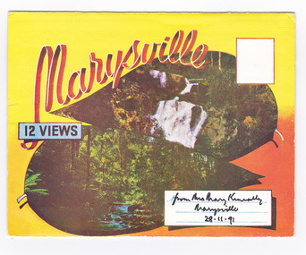 Marysville & District Historical Society
Postcard (item) - Colour photographs, Murray Views, Marysville 12 Views, 1950's
A fold out postcard of 12 colour photographs of scenes and landscapes in and around Marysville in Victoria.A fold out postcard 12 colour photographs of scenes and landscapes in and around Marysville in Victoria. These photographs were produced by Murray Views in Gympie, Queensland as a souvenir of Marysville.Marysville/ 12 VIEWS from Mrs Mary Keneally/ Marysville/ 28.11.91 PRODUCED BY MURRAY VIEWS./ GYMPIE./ Q COPYRIGHT SAMUEL LEE & CO., PRINTERS. STEAVENSON'S FALLS, MARYSVILLE, VIC. TOURISTS AT MARYSVILLE, VIC. "FRUIT SALAD FARM", MARYSVILLE MAIN STREET, MARYSVILLE, VIC. ROAD SCENE, MARYSVILLE, VIC. THE CROSSWAYS, MARYSVILLE, VIC ROAD TO CUMBERLAND VALLEY, MARYSVILLE PANORAMA FROM BLACK SPUR, MARYSVILLE ROAD, MARYSVILLE, VIC. NICHOLL'S LOOKOUT, MARYSVILLE, VIC. TREE FERNS, MARYSVILLE, VIC. THE BRIDGE, MARYSVILLE, VIC.steavenson falls (image 1), tourists in marysville (image 2), taggerty river (image 3), fruit salad farm (image 4), main street marysville (image 5), road scene marysville (image 6), the crossways (image 7), cumberland valley (image 8), black spur (image 9), nicholl's lookout (image 10), tree ferns (image 11), bridge (image 12), marysville, victoria, postcard, souvenir, murray views -
RMIT GSBL Justice Smith Collection
Report, Torrens title: compensation for loss : discussion paper, 1989
Discussion paper June 1989 New South Wales Law Reform Commission (Discussion paper 19) Law Reform Commission of Victoria (Discussion paper 16) ISBN: 0730563448torrens system -- new south wales, torrens system -- victoria, compensation (law) -- new south wales, compensation (law) -- victoria