Showing 2376 items
matching 42
-
 Port Melbourne Historical & Preservation Society
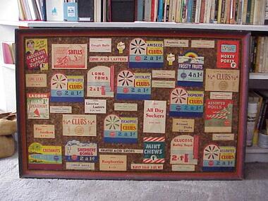
Photograph - Display board, Lagoon Confectionary labels, David Thompson, Mar 1999
Photographed by David THOMPSON when the display board was on loan from the company for Port Melbourne Festival 1999. Photos made upstairs at Pat GRAINGER'S house in natural light.One of seven digital photos of Lagoon Confectionery's display board of labels from the 1930s, 40s etc. There are also digital images of each individual label on the hard drive, numbered 1204.08-42industry - food, lagoon confectionery pty ltd -
 Ballarat Tramway Museum
Photograph - Black & White Photograph/s, Andrew Howlett?, c1971
Yields information about the appearance and operation of the main tram stop in the City in Sturt St prior to closure.Black and White photograph print of tram 42 and another bogie car at the City terminus, south side of Sturt St, c1971. Tram has the destination of Sebastopol. The Ballarat Post Office is in the view.trams, tramways, sturt st, tram 42 -
 Maldon Vintage Machinery Museum Inc
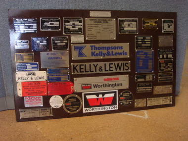
Mounted Display Board, Assembled by Flowserve
42 sample specification plates and labels of types used on machinery made be various pump manufacturers associated with Thompsons Kelly & Lewis and Flowserve. Mount is of fibreboard, painted brown on the front and black on the back.display -
 Bendigo Military Museum
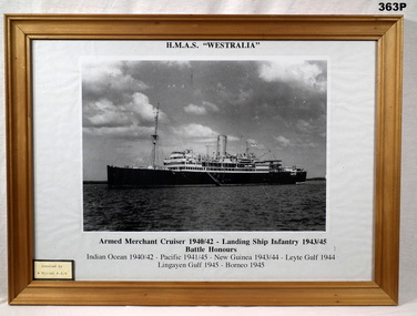
Photograph - PHOTOGRAPH, FRAMED, c.1945-46
Rectangular framed black & white photograph of HMAS Westralia. Wooden frame, glass front, white mount.Armed Merchant Cruiser 1940/42 - Landing Ship Infantry 1943/45 Battle Honours Indian Ocean 1940/42 - Pacific 1941/45 - New Guinea 1943/44 - Leyte Gulf 1944 Lindayen Gulf 1945 - Borneo 1945photography framed, hmas westralia, ran ww2 -
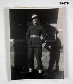 Bendigo Military Museum
Photograph - PORTRAIT, SOLDIER WW2
"Mathew Ernest Rumbelow" Lance Bombardier 2/7th Field. Enlisted 17/3/42 VX78073 at age 21. Served overseas Middle East 23/8/42 - 25/2/43 then Borneo 8/4/45 to 6/12/45.Black and White photo of Mathew Rumbelow posed in front of a building in full uniform.photograph, artillery, 2/7th field regiment, mathew ernest rumbelow -
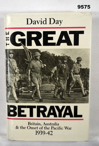 Bendigo Military Museum
Book - PACIFIC WAR, WW2, David Day, "THE GREAT BETRAYAL", 1988
"THE GREAT BETRAYAL/ BRITAIN, AUSTRALIA/ AND THE ONSET OF THE PACIFIC WAR/ 1939-42".Hard cover book with dust cover. Hard cover - cardboard, dark brown colour buckram. White colour print on spine. Dust cover - paper, black and red colour print on front, spine and back. Front illustrated with black and white photograph "Surrender at Singapore, February 1942". White colour background. 388 pages - cut, plain white paper. Illustrated black and white photographs and illustrations. publications, book, ww2, pacific war -
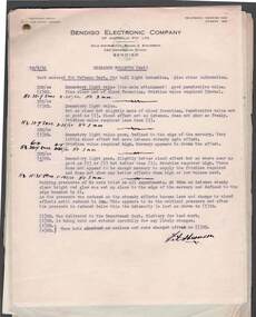 Bendigo Historical Society Inc.
Document - BILL ASHMAN COLLECTION: CORRESPONDENCE
Group of paper pinned together of various experiments. Items include Tail light invention for Defence Dept. 18/9/41, Heat of glass, Refractive Index Tests on Melbourne Tap Water 31/7/42, Research Data, Manufacture of the Buoys 18/1/43, Specifications 1/12/42, List of substances with their Atomic No., Symbol, Atomic Weight, Melting Point and Year of discovery and a hand drawn diagram for an experiment. Bendigo Electronic Company of Australia Pty Ltdsciences, instruments - general, scalebuoy, bill ashman collection - correspondence, bendigo electronic company of australia pty ltd, defence dept, capt slattery, f a stevenson -
 Ballarat Tramway Museum
Photograph - Digital image, John Ward, 28/08/1971 12:00:00 AM
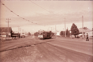
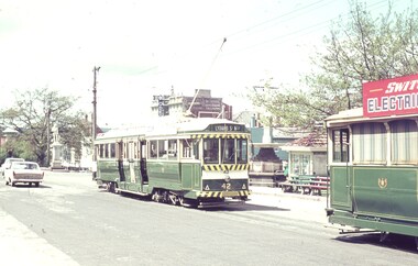
Yields information about the use of Wendouree Parade and big hail storm over Ballarat on the last full weekday of operations.Digital image of tram 42 at depot junction in Wendouree Parade, just after the heavy hailstorm of the 28 August 1971, on the last full weekday of running. The driver is changing the points. The tram has the destination of Mt Pleasant. In the background is tram 17. Photo by John Ward 20 August 1971. Slide title "04718 200871 7174-H SECV bogie tram 42 single truck tram 17 Wendouree Pde at Stafford Court Lake Wendouree Ballarat Vic"trams, tramways, wendouree parade, depot junction, closure, mt pleasant, tram 42, tram 17 -
 Frankston RSL Sub Branch
Sextant, Bubble
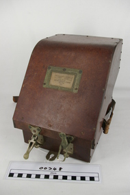
Bubble Sextant model Mark 1XA type A.M. 6B/218 in protective storage box. Complete, with operation instructions. This is an aviation navigation instrument used by the RAF and RAAF during the World War 2 era. A sextant is used to measure the altitude of celestial bodies above a horizontal line of reference. A navigator can use the horizon as this line of reference, but when an aircraft is above the clouds or flying at night, the navigator can’t see the horizon. The bubble sextant solves this problem by providing an artificial horizon.The storage case has a label with the following: "A.M. 6B/218 MK IX A" and the number "10772/42 (V)" -
 Ballarat Tramway Museum
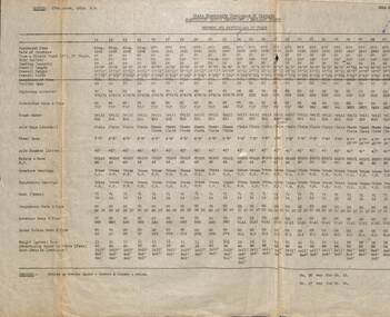
Document - List, State Electricity Commission of Victoria (SECV), "Numbers and Particulars of Trams" - Ballarat, 27/3/1952
List titled "Numbers and Particulars of Trams", copied 27 March 1952. Gives details of where purchased from, date of purchase, type, body builder, seating capacity, overall length, overall height, overall width, condition of tram, trolley base, Lightning arrester, controller make and type, Truck Maker and type, type of truck, axle type, wheelbase, axle diameter, motors type and maker, Motor horsepower, Armature bearings, suspension bearings, gear teeth, Air compressor make and type, Brake Valves make and type, Governor make and type, Weight in tons and details of advertising space in racks. See also 8721 and 8722 for other versions - different dates and 8690 for a Bendigo list. Note: Framed copies of both Ballarat and Bendigo are held in the depot. Notes the renumbering of trams 15 and 22.Yields information about the dimensions and equiipment on Ballarat Tramcars operated by the SEC.Typed List of tramcars and their details for Ballarat.handwritten note regarding tram 37 "not in service" and "41, 42, 43" added to top right hand side.tramcars, ballarat, equipment, lists, data -
 Maldon Vintage Machinery Museum Inc
French Curves
.1) Wooden box with hinged lid. 22 wooden and 3 plastic flat curved patterns loose in the box. Several are numbered. .2) 3 clear plastic curves in a pouch. Made in Italy. .3) 3 clear plastic curves in a pouch. Made in Italy. .3 .....31) Plastic curves. French curves are used in a drawing office to draw a smooth best fit line through a number of points..25) "42 / Engineering / TB5" etched into plastic. .2 & .2) Pouches marked "LONGO Made in Italy" in gold.trades, drafting -
 Kilmore Historical Society
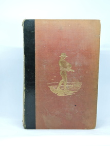
The Book of the Farm, 1855
Agricultural methods of the 1800's.Red/brown cloth-bound hardcover with black cloth spine. Front flyleaf missing. Illustrations, charts, graphs. Cover corners worn, spine missing. Body of book detaching from covers. Loose pages. 674 pp. + illustrations. Vol. 1 of 2. Poor condition.P.1 '42' (crossed out in red ink). Inside cover blurred Kilmore Mechanics' Institute stamp.agriculture, kilmore mechanics institute library. -
Bendigo Historical Society Inc.
Book - GETTING GOLD - AN ABC OF PROSPECTING IN AUSTRALIA, 1931
GETTING GOLD - AN ABC OF PROSPECTING IN AUSTRALIA. By 'Fossiker' An ABC of prospecting in Australia, explaining panning, cradling, puddling, dollying & sluicing. Price two shillings and six pence 42 pages with folded maps and illustrations.'Fossiker', printed by Robertson & Mullens Limited, Melbournegold, prospecting in australia, gold, mining, prospecting -
 Ballarat Tramway Museum
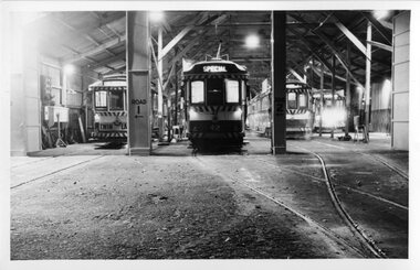
Photograph - Black & White Photograph/s, Len Millar, May. 1970
Yields information about the tram depot at night.Black and white photograph on card paper of SEC trams 11, 42 and 36 in the depot at night. The photographer notes it was a cold autumn night. Shows the tracks into the depot. Photo by Len Millar May 1970.Detailed notes on rear in ink and pencil by Len Millar and Keith Kings - see image i2.trams, tramways, night photo, depot, tram 11, tram 42, tram 36 -
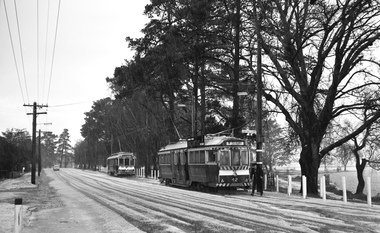
 Ballarat Tramway Museum
Negative, Campbell Duncan, 10/08/1971 12:00:00 AM
Yields information about tram operations and the street views in the area of the crossing Albert St, Sebastopol.Photographs taken on 10/8/1971 by Campbell Duncan of No. 42 crossing Albert St, Sebastopol at Ophir St, with the destination of Lydiard St North. The person on the right hand side appears to be Bill Jessup.trams, tramways, albert st, sebastopol, ophir st, tram 42 -
 Bendigo Historical Society Inc.
Slide - DIGGERS & MINING. DIGGERS AND MINERS, c1853
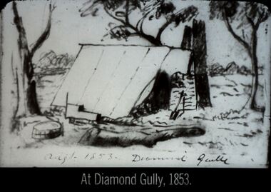
Diggers & Mining. Diggers and miners. At Diamond Gully, 1853. Slide; shows a miners tent. Markings on picture August 1853 Diamond Gully. Markings: 42 994:LIF I. Used as a teaching aid.hanimounteducation, tertiary, goldfields -
 8th/13th Victorian Mounted Rifles Regimental Collection
Booklet - Owen, Owen Gun Instruction Book
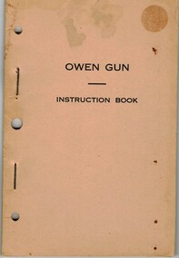
The Owen Machine Carbine was designed and manufactured in Australia in 1942 when Australia was in desperate need of weapons.The OMC proved highly effective and remained in service till 1960s.Rare publication to accompanyweapon designed and manufactured in Australia during WW11Natural covered booklet " Owen gun Instruction Book " published by Lysaght's Port Kembla July 1942 to accompany weapons manufactured at te Company's plant. 42 pages and fold out sheet, stapled.military, owen, machine carbine, wwii, world war two, lithgow -
 City of Ballarat Libraries
Postcard - Card Box Photographs, Gold Cairn, Ballarat circa 1951
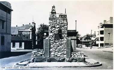
Located on Sturt Street in front of Parent Place. Valentine Series V 42.gold cairn, monument, mining, sturt street, public -
 Ballarat RSL Sub-Branch Inc.
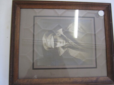
Photograph - Framed Harold Robert George MARSHALL
Ser No - 58722, 42 Battn, Joined Ballarat RSL 30/6/1920photo/pictures, ballarat rsl, ballarat -
 University of Melbourne, Burnley Campus Archives
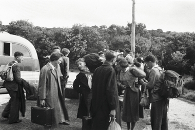
Album - Black and white negatives and prints, John Sutherland, John L. Sutherland Collection, c. 1954
John L. Sutherland graduated in 1954. See B09.0004(42) photograph of him.1. 10 black and white photographs, some with inscriptions, in Ilford Films paper packet - Burnley and Wilson'd Promontory excursion. 2. Black and white negatives from Kodak packet containing 76 negatives, proofs made and scanned - Burnley and excursions. 3. Kodak packet containing roll of 35 negatives - Burnley and Dinner Dance.4. Cardboard Kodak negative box with roll of 34 negatives - excursion to Wilson's Promontory.5. CD of scanned 3 and 4. j. l. sutherland, students, wilson's promontory excursion, administration building, pruning, helen eastman, glasshouses, cacti, students working outside, cricket, luffmann ponds, horses, orchard, insid, students in class, locker room, changing room, excursions, dahlias, tractor, royal agricultural show, student outside classes, speech day -
 Victorian Harness Racing Heritage Collection at Lord's Raceway Bendigo
Photograph - Framed photo finish, A. Copley, Akeley, winner, Richmond Ladies Bracelet 3/11/1919, 3 November 1919
Large rectangular black and white harness racing photo finish mounted on white paper and framed in a thin wooden frame (probably remounted and reframed)Bottom centered in black ink: Richmond 3/11/1919 / Ladies Bracelet / Won by "Akeley" At the back stamp in blue ink: BG / Bethany Gallery / 116 Bridge Street, Bendigo, Vic 3550/ Ph: (054) 42 4771 Fax: (054) 42 3480trotting, richmond, akeley, ladies bracelet, joe hillier, 1919, harness racing -
 Bendigo Historical Society Inc.
Slide - DIGGERS & MINING. DIGGERS AND MINERS, 1800s
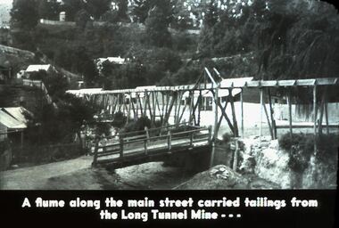
Diggers & Mining. Diggers and Miners. A flume along the main street carried tailings from the Long Tunnel Mine. Picture shows this. Markings: 42 994.5 WAL. Used as a teaching aid. Used as a teaching aid.hanimounteducation, tertiary, goldfields -
 Bendigo Historical Society Inc.
Photograph - ROY J MITCHELL COLLECTION: BYLANDS TRAM MUSEUM
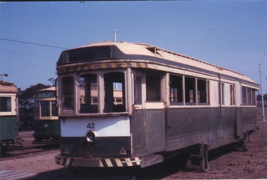
Colour photograph of tram, not restored, parked at Bylands Tram Museum. Written on back: 1983 Bylands Tramway Museum, ex Bendigo No. 42 under restoration, formerly MTB C C?SI (indecipherable) car.Roy J Mitchellbendigo, tramways, no 42 tram -
 Ballarat Tramway Museum
Slide - 35mm slide/s, Robert Thomson, 27-4-1965?
Yields information about trams in Sturt St during 1965.Agfa blue/white mount, colour slide of trams 42 and a single trucker at the City terminus, Sturt St. Possible date 27-4-1965, based on the slide mount and item 7483. Overexposed photo. tramways, trams, sturt st, tram 42 -
 Bendigo Military Museum
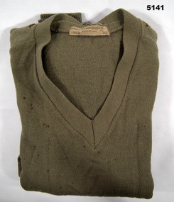
Uniform - JUMPER, Bruce Pie Industries Ltd, 1962
"Items in collection of K.W. Peatling" refer cat no 5140.2 Box 173 for his service detailsknitted wool jumper, v neck with long sleeves, cotton bound slits in shoulders for epauletteslabel on back neck edge, burgundy coloured writing "BRUCE PIE INDUSTRIES LTD. QUEENSLAND 1962 SIZE 42"wool uniform. military issue, wool jumper -
 Greensborough Historical Society
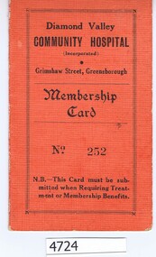
Membership card, Diamond Valley Community Hospital, Diamond Valley Community Hospital Membership Card, 16/06/1942
Membership card for Diamond Valley Community Hospital. Members could obtain reduced in-patient fees on presentation of this card.Textured card, salmon on front, white on inside, folded once, with receipt pasted in. With covering letter to Noel Withers from the donor, Bob Manuell"F. Squire, Gladstone Rd Briar Hill, 17/6/42, Life 30 pounds. [Issued by] P Stubley"diamond valley community hospital -
 Marysville & District Historical Society
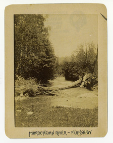
Photograph (Item) - Black and white photograph, Maroondah River - Fernshaw, c1900
An early black and white photograph of the Watts River at Fernshaw. The photograph has been incorrectly labeled as the Maroondah River - Fernshaw.An early black and white photograph of the Watts River at Fernshaw. The photograph has been incorrectly labeled as the Maroondah River - Fernshaw.ARMSTRONG COLLECTION 42 STATION STREET/ SANDRINGHAM 3191/ TEL. (03) 9521 5442/ IAN M.L. ARMSTRONG OAMwatts river, fernshaw, maroondah river, victoria -
 Marysville & District Historical Society
Photograph (Item) - Black and white photograph, Fernshaw, c1900
An early black and white photograph taken at Fernshaw.An early black and white photograph taken at Fernshaw. Fernshaw was a rural township 63 km north-east of Melbourne and 10 km north-east of Healesville. Situated on the Watts River, near where a log had fallen making a convenient crossing, Fernshaw was settled in the 1860s. It provided good country for orchards and berry growing. The location was at the foot of Blacks Spur, with Mounts Juliet and Mondah rising on either side, providing spectacular scenery. There were nearby fern gullies giving rise to the name – ‘shaw’ is old English for thicket or wood. By 1875 Fernshaw had a post office (1865), two hotels, a school (1871) and stores. It was famed for its beauty, attracting tourists. In 1886 the Melbourne and Metropolitan Board of Works began work on the Watts River water catchment scheme – later to become Maroondah – and the Board obtained approval for the catchment country to be reserved and kept free of settlement. This required the removal of the Fernshaw township, which was completed by about 1890. The area was described in the 1903 Australian handbook:ARMSTRONG COLLECTION 42 STATION STREET/ SANDRINGHAM 3191/ TEL. (03) 9521 5442/ IAN M.L. ARMSTRONG OAMfernshaw, healesville, watts river, orchard, berry orchard, blacks spur, black spur, mount juliet, mount mondah, maroondah dam, victoria -
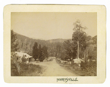 Marysville & District Historical Society
Photograph (Item) - Black and white photograph, Marysville, c1900
An early black and white photograph of the main road in Marysville in Victoria showing the Keppels Australian Hotel.An early black and white photograph of the main road in Marysville in Victoria showing the Keppels Australian Hotel which was built and opened by the Keppel Family in 1865. The Keppels Australian Hotel was the first hotel to be opened in Marysville. The Keppel Family were among Marysville's earliest pioneering families.ARMSTRONG COLLECTION 42 STATION STREET/ SANDRINGHAM 3191/ TEL. (03) 9521 5442/ IAN M.L. ARMSTRONG OAMaustralian hotel, marysville, keppel family, maurice john keppel, keppels australian hotel, keppels hotel, victoria -
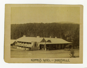 Marysville & District Historical Society
Photograph (Item) - Black and white photograph, Keppel's Hotel - Marysville, c1900
An early black and white photograph of the Keppels Australian Hotel in Marysville in Victoria.An early black and white photograph of the Keppels Australian Hotel which was built and opened by the Keppel Family in 1865. The Keppels Australian Hotel was the first hotel to be opened in Marysville. The Keppel Family were among Marysville's earliest pioneering families.ARMSTRONG COLLECTION 42 STATION STREET/ SANDRINGHAM 3191/ TEL. (03) 9521 5442/ IAN M.L. ARMSTRONG OAMkeppel hotel, keppels australian hotel, australian hotel, keppel family, maurice john keppel, marysville, victoria