Showing 2589 items matching "aerial"
-
 Peterborough History Group
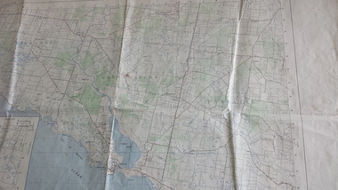
Map - Government map, Government Printer, Port campbell, 1957
Aerial survey map showing roads, vegetation and other landscape features.Significant because it shows the detail of the region in 1957Original 1957 State Aerial Survey Map of Port Campbell region, including Peterboroughpeterborough, aerial survey map, maps, port campell -
 Kew Historical Society Inc
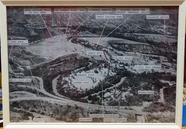
Photograph, Yarra Bend Park Trust, Yarra Bend Park Facilities, 1940s
Old aerial photograph of Yarra bend Park labelled with park facilitiesFramed annotated aerial photograph of Yarra Bend Park. The white frame is original to the work.yarra bend park, sports facilities - kew - fairfield, sir herbert olney oval, fairfield hospital, chandler bridge, deep rock swimming basin, kane's footbridge -
 Glenelg Shire Council Cultural Collection
Photograph, Photograph Reclamation and Canal Work, 1959
Port of Portland Authority ArchivesFront: General view: Aerial view West showing wharf and canal areas. November 1959 - typed.port of portland -
 Bendigo Military Museum
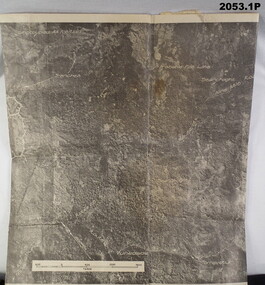
photograph - PHOTOGRAPHS WW2, 2053) 24/10/1943; 2053.1) 17/09/1944
2053.1) Photo's "Aerial", Binder form, 4 pages, paper yellowed, photo's written on, area description under each one. B&W. 2053.2) Photo, large Aerial, B&W, "Vunakanau Plantation". Photo written on showing military positions, scale. Mosaic, Toma to Dieldimans Corner (Vunakanau) 17 Sep 1944.photography-photographs, military history - airforce, aerial -
 8th/13th Victorian Mounted Rifles Regimental Collection
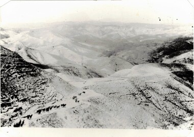
Photograph - Aerial photograph desert column
Example of aerial photography during WWI in Middle East.Black and White aerial photograph of column of horses in desert terrainmilitary, wwi, world war one, desert, horses, aerial -
Port Fairy Historical Society Museum and Archives
Photograph
martin's Point from the air very early (research ongoing)black and white aerial photograph of Martin's Point Port Fairyaerial, martins point, dredge, boat, river, land -
 Greensborough Historical Society
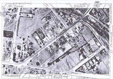
Aerial Photograph, Greensborough, 1945_
Aerial photograph of Greensborough showing residents and businesses in the area. Annotations by Bill Cecil.Photocopy of enlargement of 1945 aerial photograph, with 2 p. of annotations indicating locations of residents and businessesgreensborough, bill cecil -
 Greensborough Historical Society
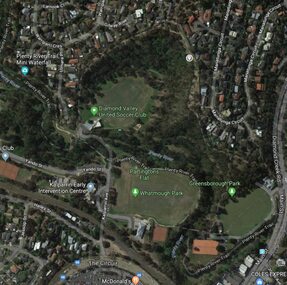
Aerial Photograph - Digital Image, Greensborough central with modern landmarks, 2015_
Aerial photograph of Greensborough showing modern landmarks and businesses, including Partington's Flat, Whatmough Park, Plenty River Trail. Bounded by Diamond Creek Road to the East and the Plenty River to the East, The Circuit to the South. Aerial photograph in colour with overlay text indicating modern landmarksgreensborough, manatunga circuit greensborough, plenty river, diamond creek road greensborough, the circuit greensborough, aerial photograph -
Frankston RSL Sub Branch
Computer, Navigation
Aerial Dead Reckoning Computer in leather pouch. This device was used as a navigational aid by aircraft pilots and crew. W&G Aerial Dead Reckoning Computer R.A.A.F. Mk 1 Made in Australia by White & Gillespie Front Scale: Distance Naut Miles, True Air Speed (Time Min, Hrs, Density Altitude, Air Temp ) Back Scale: Wind Correction Angle( True Heading ) The leather pouch has the following printed on the outside "W&G Aerial Dead Reckoning Computer R.A.A.F. Mk 1" -
 Bendigo Military Museum
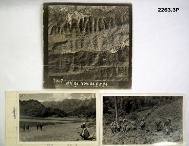
Photograph - PHOTOGRAPHS, BURMA, 26th Nov 1944
Items in the collection re Ian McLeod RWAFF, refer Cat No 2262.2.1) Aerial Sepia photograph countryside Burma. .2) Black and White photo Burma river, mountains and "kumi" natives. .3) Black and White photograph Burmese Jungle..1) “4191. 26 Nov. 44” .2) “Burmese Campaign 1944” .3) “Burmese Jungle 1944”burma, aerial, photographs -
 Mission to Seafarers Victoria
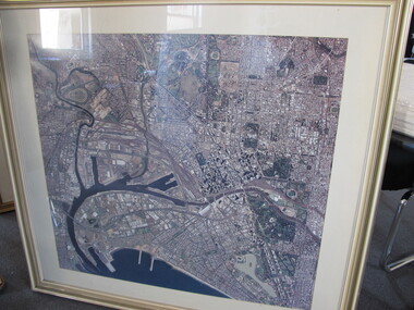
Photograph - Aerial Photograph, 1980-1997
Aerial view of Melbourne pre October 1997 as the Docklands stadium, landmark of the new precinct is not yet built.Large framed and glazed print of aerial colour photograph of the Yarra river and Docklands, C - 1982 - 1995 docklands, melbourne, aerial view, yarra river, city, port melbourne, albert park -
Creswick Campus Historical Collection - University of Melbourne
Still Image, 1968
Subject: Creswick 1968 Project . 1 x annotated map in envelope marked Run 3 No's 30 - 38 with runs marked up from aerial phtographs flown 1956 - 1968 on drafted plan of Creswick Plantations. 1 x topographical map marked Creswick with annotation "Mapsheet key diagram". 1 x topographical map marked Ballarat annotated with a grid of numbers. 13 brown envelopes marked Run 1 -3 No. 21 - 38 (missing sequences) of c.44 prints total. Mix of black and white and colour. Range of dates. Stored in a brown cardboard file box marked Creswick 1968 Project.Aerial Photographs -
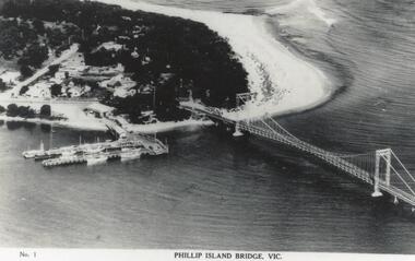
 Phillip Island and District Historical Society Inc.
Photograph, San Remo & Phillip Island, 1940's
Aerial view of first Phillip Island Suspension Bridge completed in 1940 and opend by Hon. Albert Dunstan MLA, Premier of Victoria.Aerial photograph of Mainland and Phillip Island with connecting bridge from Newhaven, showing San Remo.local history, photographs, civil engineering, bridges, phillip island bridge, black & white photograph, jack jenner collection, phillip island bridges, public construction -
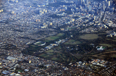 Ballarat Heritage Services
Digital Photograph, L.J. Gervasoni, Royal Park CBD and zoo from the air, 2016
Digital Image showing an aerial view of the Melbourne Central Business District and Royal Park.aerial, melbourne, yarra river, cbd, royal park, zoo -
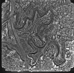
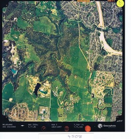 Greensborough Historical Society
Aerial photograph, Qascophoto, Greensborough, 03/11/1986
Aerial survey of Plenty Gorge Park area, including Greensborough by-pass construction and Metropolitan Ring Road reservation.An historical view of developing GreensboroughColour aerial photograph QAS 2504c run 5 3/11/86 1:15,500 by Qascophotoplenty gorge park, greensborough bypass, metropolitan ring road -
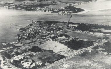
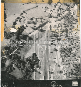 Eltham District Historical Society Inc
Photograph - Aerial Photograph, Main Road and Anzac Ave intersection, Hurstbridge, 12 Apr. 1954
Victorian Railways Aerial SurveyStamped VR Aerial Survey This print is not rectified Scale Approx 160' to 1 inch Date Photographed 12.4.54 Written Series 33, Item 9shire of eltham archives, aerial photo, main road, anzac avenue, hursbridge, parker road, hurstbridge railway station, rose road -
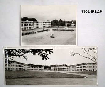 Bendigo Military Museum
Photograph - SELARANG BARRACKS, 1970
Various photos of Selarang Barracks in Singapore in 1970. Some aerial and some ground level views. Refer items in Collection of LLoyd Farrell. Refer Cat 7889P.1. Photo of 1 RAR on parade for Trooping of the Colours in 1970 at Selarang Base in Singapore. Covering 'A' 'B' 'C' and Admin Company. 2. Extended portrait photo of the Parade Square and buildings of Selarang Base, Singapore in 1970. 3. Aerial photo of Selarang Barracks from a distance. 4. Aerial photo of Selarang Barracks 1970. 5. Aerial photo of Changi Prison 1970 in Singapore.Written on back. 1. "1 M1+" 2. “Selarang Barracks 1970 occupied by 1st RAR” 4. “Selarang 70” 5. "Changi Prison 1970 Singapore".photograhs, changi, selarang, 1970, lloyd farrell. -
4th/19th Prince of Wales's Light Horse Regiment Unit History Room
Station Radio C13
Used by all Royal Australian Armoured Corps vehicles. Mid 1950's to mid 1970'sEquipment used by the RegimentA HF voice and CW sender-receiver for use in vehicles or as ground station. Consists three main units - the sender/receiver, the power supply unit, and aerial tuning unit. Power supply was either 12 or 24 volt. Frequency range 1.5 - 12.0 Mc/s. Operating range up to 25 miles.Radio - No 0549, Supply unit vibratory - No 1545, Aerial Tuning Unit No 1397radio, c13 -
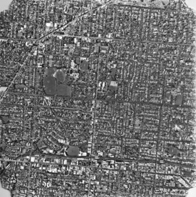
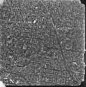
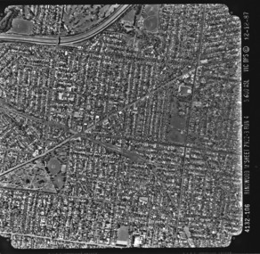 Kew Historical Society Inc
Photograph - Aerial photograph: City of Kew No.1/6, Department of Property & Services (Victoria), 12/12/1987
One of a series of six small square black and white aerial photographs of Kew taken and produced by the Victorian Department of Property Services.Aerial photographs, of which the Society has a number in its collection, allow researchers to identify changes in urban infrastructure and demographics over timeAerial photograph of a part of Kew, taken by photographers employed by the Victorian Department of Property and Services in December 1987.4132-106 Ringwood M'Sheet 7922-3 Run 4 5600'ASL Vic DPS © 12-12-87aerial photography, aerial photograph -- kew (vic.) -
 Kew Historical Society Inc
Photograph, Department of Property & Services (Victoria), City of Kew No.2/6, 12/12/1987
One of a series of six small square black and white aerial photographs of Kew taken and produced by the Victorian Department of Property Services.Aerial photographs, of which the Society has a number in its collection, allow researchers to identify changes in urban infrastructure and demographics over timeAerial photograph of a part of Kew, taken by photographers employed by the Victorian Department of Property and Services in December 1987.aerial photograph - kew -
 Kew Historical Society Inc
Photograph, Department of Property & Services (Victoria), City of Kew No.3/6, 12/12/1987
One of a series of six small square black and white aerial photographs of Kew taken and produced by the Victorian Department of Property Services.Aerial photographs, of which the Society has a number in its collection, allow researchers to identify changes in urban infrastructure and demographics over timeAerial photograph of a part of Kew, taken by photographers employed by the Victorian Department of Property and Services in December 1987.aerial photograph - kew, aerial photographs -
 Kew Historical Society Inc
Photograph, Department of Property & Services (Victoria), City of Kew No.4/6, 12/12/1987
One of a series of six small square black and white aerial photographs of Kew taken and produced by the Victorian Department of Property Services.Aerial photographs, of which the Society has a number in its collection, allow researchers to identify changes in urban infrastructure and demographics over timeAerial photograph of a part of Kew, taken by photographers employed by the Victorian Department of Property and Services in December 1987.aerial photograph - kew, aerial photographs -
 Kew Historical Society Inc
Photograph, Department of Property & Services (Victoria), City of Kew, No.5/6, 12/12/1987
One of a series of six small square black and white aerial photographs of Kew taken and produced by the Victorian Department of Property Services.Aerial photographs, of which the Society has a number in its collection, allow researchers to identify changes in urban infrastructure and demographics over timeAerial photograph of a part of Kew, taken by photographers employed by the Victorian Department of Property and Services in December 1987.aerial photograph - kew, aerial photographs -
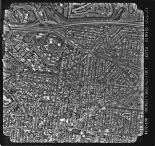 Kew Historical Society Inc
Photograph, Department of Property & Services (Victoria), City of Kew, No.6/6, 12/12/1987
One of a series of six small square black and white aerial photographs of Kew taken and produced by the Victorian Department of Property Services.Aerial photographs, of which the Society has a number in its collection, allow researchers to identify changes in urban infrastructure and demographics over timeAerial photograph of a part of Kew, taken by photographers employed by the Victorian Department of Property and Services in December 1987.4312-108 Ringwood M'Sheet 7922-3 Run 4 5600'ASL Vic DPS © 12-12-87aerial photograph - kew, aerial photographs -
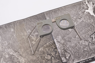 Forests Commission Retired Personnel Association (FCRPA)
Pocket Stereoscope
This pocket stereoscope was used to view a pair of separate and overlapping aerial photos as a single three-dimensional image. It was small and could be easily used in the field. Larger, mirror stereoscope were also available in some offices. The aerial images were used to map forest types, timber stands, new roads and tracks, firebreaks, boundaries of timber harvesting, plantations, bushfires, insect and disease attack and so on In 1928, the Forests Commission undertook its first major aerial photography project over 15,000 acres of forest which is said to be the first of its kind in Australia. During the Second World War, large areas of Victoria were photographed by RAAF and used to produce orthophoto maps. By 1945 aerial photography of 13,000 square miles (3.4 M ha) was completed, including much of the inaccessible eastern forests. The Forests Commission started developing its own small format photography in the early 1970s. Simple, cheap and rapid methods of obtaining photographs using 70mm and 35mm cameras were developed Small pocket stereoscope to interprete aerial photographs in the field Adjustable lenses on foldaway wire legsSokkisha Tokyoforest measurement, surveying, forests commission victoria (fcv) -
 Phillip Island and District Historical Society Inc.
Photograph, Suspension Bridge, 1940
Post Card showing Aerial view of completed Bridge - San Remo 1940. One of the Jack Jenner Collection.Aerial View of Suspension Bridge showing San Remo side. Vessels at pier, middle, left and beach top right.Phillip Island Bridge, Vic. No. 1.local history, photographs, civil engineering, bridges, maritime technology, boats, phillip island bridge, black & white photograph, jack jenner collection, phillip island bridges, public construction -
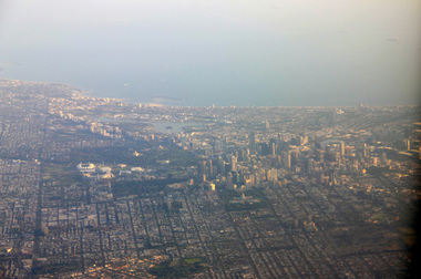 Ballarat Heritage Services
Digital Photograph, L.J. Gervasoni, Melbourne CBD and Albert Park Lake on approach Melbourne Airport, 2016
Digital Image showing an aerial view of the Melbourne Central Business District and Albert Park.aerial, melbourne, yarra river, cbd, albert park, lake, port phillip bay -
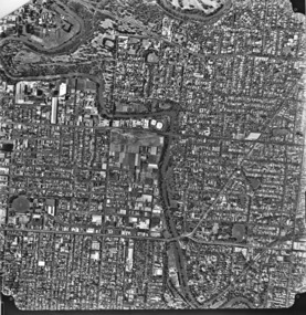
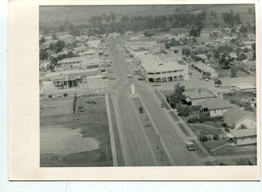 Orbost & District Historical Society
black and white photographs, C 1960s - 1970s
3290.1 is an aerial photograph of the township of Orbost looking south along Nicholson Street. The tennis courts and recreation reserve are on the left. The War Memorial, Commonwealth Hotel at the Saisbury Street intersection is in the centre of the photograph. 3290.2 is an aerial view of the Orbost township looking north, showing the bridge across the Snowy River in the foreground,These photographs are detailed pictorial records of the Orbost township C 1960s - 1970s.Two photographs which are aerial views of a township showing streets, buildings and vehicles. 3290.1 is a black / white photograph. 3290.2 is a coloured photograph.orbost-township-c1960s-1970s aerial-photograph-orbost -
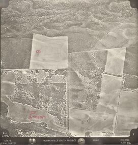 Bendigo Historical Society Inc.
Photograph - MURRAYVILLE SOUTH PROJECT
State Aerial Survey. A set of aerial surveys related to the Murrayville South Project. Run 1. Vic. 2162. 29-2-1968. 53 photos.photograph, aerial, murrayville south project, photos, murrayville south project, state aerial survey, surveys, murrayville, photographs, photography, aerial photography -
Glenelg Shire Council Cultural Collection
Photograph - Photograph - Portland Harbour with oil rig, c. 1966
Port of Portland AuthorityBack: harb019 Portland Harbour Trust 7 - black pen. Typed onto white paper and attached to rear of photo, " Aerial photograph of Portland Harbour depicts the development and growth in port trade since the first stage of construction was sompleted in Novemer, 1960."port of portland archives, portland harbour, oil rig