Showing 1535 items matching "aerial photograph"
-
 St Kilda Historical Society
Photograph - Photo map, Department of Crown Lands and Survey (1857-1983), 22/01/1970
... Black and white aerial photograph... Black and white aerial photograph Photograph Photo map ...One of a series of photo-maps produced for the Department of Crown Lands and Survey (1857-1983). For correlation with a current map, and access to other historical photo maps of Victoria, see the Historic Photo-Maps Index published by the Department of Environment, Land, Water and Planning at https://services.land.vic.gov.au/DELWPmaps/historical-photomaps/Black and white aerial photographVic 2358 Department of Crown Lands and Survey Victoria,.© Melbourne 1970 Project Run 42E 22.1.70 5,100 ASL 77st kilda, st kilda east, st kilda marina, elwood, elwood canal, elsternwick park, point ormond, balaclava, mc moran reserve, ripponlea, st kilda botanical gardens, peanut farm, 1970 -
 St Kilda Historical Society
Photograph - Photo map, Department of Crown Lands and Survey, 22/01/1970
... Black and white aerial photograph... Project Run 43E 22.1.70 5,100 ASL 208 Black and white aerial ...One of a series of photo-maps produced for the Department of Crown Lands and Survey (1857-1983). For correlation with a current map, and access to other historical photo maps of Victoria, see the Historic Photo-Maps Index published by the Department of Environment, Land, Water and Planning at https://services.land.vic.gov.au/DELWPmaps/historical-photomaps/Black and white aerial photographVic 2358 Department of Crown Lands and Survey Victoria,.© Melbourne 1970 Project Run 43E 22.1.70 5,100 ASL 208elwood, elwood beach, point ormond, elwood park, elwood canal, mc moran reserve, 1970 -
 St Kilda Historical Society
Photograph - Photo map, Department of Crown Lands and Survey, 22/01/1970
... Black and white aerial photograph... 41E 22.1.70 5,100 ASL 66 Black and white aerial photograph ...One of a series of photo-maps produced for the Department of Crown Lands and Survey (1857-1983). For correlation with a current map, and access to other historical photo maps of Victoria, see the Historic Photo-Maps Index published by the Department of Environment, Land, Water and Planning at https://services.land.vic.gov.au/DELWPmaps/historical-photomaps/Black and white aerial photographCONTROLLED Vic 2358 Department of Crown Lands and Survey Victoria,.© Melbourne 1970 Project Run 41E 22.1.70 5,100 ASL 66st kilda, albert park, st kilda west, catani gardens, st kilda botanical gardens, st kilda pier, st kilda beach, 1970 -
 St Kilda Historical Society
Photograph - Photo map, Department of Crown Lands and Survey, 22/01/1970
... Black and white aerial photograph... 42E 22.1.70 5,100 ASL 75 Black and white aerial photograph ...One of a series of photo-maps produced for the Department of Crown Lands and Survey (1857-1983). For correlation with a current map, and access to other historical photo maps of Victoria, see the Historic Photo-Maps Index published by the Department of Environment, Land, Water and Planning at https://services.land.vic.gov.au/DELWPmaps/historical-photomaps/Black and white aerial photographVic 2358 Department of Crown Lands and Survey Victoria,.© Melbourne 1970 Project Run 42E 22.1.70 5,100 ASL 75st kilda, st kilda beach, st kilda marina, point ormond, st kilda pier, 1970 -
 St Kilda Historical Society
Photograph - Photo map, 14/12/1963
... Black and white aerial photograph... Lens 205 152.70 M/M 5.150 177 Black and white aerial photograph ...One of a series of photo-maps produced for the Department of Crown Lands and Survey (1857-1983). For correlation with a current map, and access to other historical photo maps of Victoria, see the Historic Photo-Maps Index published by the Department of Environment, Land, Water and Planning at https://services.land.vic.gov.au/DELWPmaps/historical-photomaps/Black and white aerial photographVic 1807 Melbourne 1963 Project Run 16 14.12.1963 Lens 205 152.70 M/M 5.150 177st kilda, st kilda pier, catani gardens, middle park, albert park, st kilda west, st kilda beach, 1963 -
 St Kilda Historical Society
Photograph - Photo map, Department of Crown Lands and Survey, 22/01/1970
... Black and white aerial photograph... aerial photograph Photograph Photo map Department of Crown Lands ...One of a series of photo-maps produced for the Department of Crown Lands and Survey (1857-1983). For correlation with a current map, and access to other historical photo maps of Victoria, see the Historic Photo-Maps Index published by the Department of Environment, Land, Water and Planning at https://services.land.vic.gov.au/DELWPmaps/historical-photomaps/Black and white aerial photographVic 2358 Department of Crown Lands and Survey Victoria,.© Melbourne 1970 Project Run 41E 22.1.70 5,100 ASL 64st kilda, st kilda cemetery, balaclava, st kilda east, windsor, caulfield north, alma park, 1970 -
 St Kilda Historical Society
Photograph - Photo map, 22/01/1970
... Black and white aerial photograph... Black and white aerial photograph Photograph Photo map ...One of a series of photo-maps produced for the Department of Crown Lands and Survey (1857-1983). For correlation with a current map, and access to other historical photo maps of Victoria, see the Historic Photo-Maps Index published by the Department of Environment, Land, Water and Planning at https://services.land.vic.gov.au/DELWPmaps/historical-photomaps/Black and white aerial photographVic 2358 Department of Crown Lands and Survey Victoria,.© Melbourne 1970 Project Run 43E 22.1.70 5,100 ASL 206elwood, elsternwick, elsternwick park, 1970 -
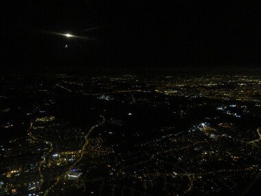 Ballarat Heritage Services
Photograph - Photograph - Colour, London by night aerial, 2017
... Aerial photograph of London by night. ... photograph of London by night. London by night aerial Photograph ...Aerial photograph of London by night. london, night, england, aerial, lights -
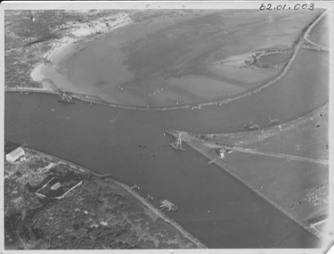 Port Fairy Historical Society Museum and Archives
Photograph - photograph-mounted, R.W.Golding, 1925
... Black and white aerial Photograph... Martins's Point Moyne River Black and white aerial Photograph ...Flight taken in 1925 by Mr R.W.Golding Black and white aerial PhotographMartins's Point Moyne Riveraerial view, martin's point, moyne river, r.w.golding, flight -
 Vision Australia
Photograph - Image, Association for the Blind offices in Kooyong aerial view
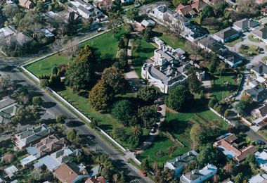
... Aerial photograph in brown frame..... association for the blind Kooyong Tennis Centre Aerial photograph ...Aerial view of Kooyong. The Kooyong Tennis Centre, Glenferrie Road, train station, Talbot Crescent, Monash Freeway and parklands are clearly visible. Few trees are lining the roadway around the sporting fields, the Glenferrie Road building has not expanded and the Blind Cricket pavilion is not yet built. Aerial photograph in brown frame.association for the blind, kooyong tennis centre -
 Vision Australia
Photograph - Image, Association for the Blind offices in Kooyong aerial view
... Aerial photograph in white frame.... association for the blind Kooyong Tennis Centre Aerial photograph ...Aerial view of Kooyong. The Kooyong Tennis Centre, Glenferrie Road, train station, Talbot Crescent, Monash Freeway and parklands are clearly visible. Few trees are lining the roadway around the sporting fields, the Glenferrie Road building has not expanded and the Blind Cricket pavilion is not yet built. Aerial photograph in white frameassociation for the blind, kooyong tennis centre -
 Vision Australia
Photograph - Image, Aerial view of Elanora Nursing Home, 1980-1989
... Aerial photograph mounted on board... elanora home (brighton) Aerial photograph mounted on board Aerial ...Aerial view of Elanora Nursing Home. Mair Street and the train line are clearly visible.Aerial photograph mounted on boardassociation for the blind, elanora home (brighton) -
 Phillip Island and District Historical Society Inc.
Photograph, Historic aerial photographs of Phillip Island, Cowes, Rhyll, Cape Woolamai and San Remo, 1930s
... aerial photograph... Woolamai Phillip Island Bridge Cowes aerial photograph Digital ...Photos taken by an unknown pioneer aviator researched by Kevin O'Reilly who has written a book "Flyers of Time" on pioneer aviation. Photos show the Island and San Remo prior to development and before the bridge was built from the mainland.HistoricalA C D Rom and USB of historic aerial photos about 1930s - 1940s of Phillip Island, Cowes, Rhyll, San Remo and Woolamai. Both formats contain the same 7 photos. Also a letter explaining the history of the photos.photographs, san remo, rhyll, cape woolamai, phillip island bridge, cowes, aerial photograph, digital media, residential development, newhaven -
 Phillip Island and District Historical Society Inc.
Photograph, Aerial photographs of Phillip Island and letter from Joshua Gliddon to June Gould
... aerial photograph... Photograph aerial photograph joshua gliddon mchaffie family Sambell ...Joshua Gliddon wrote Phillip Island in Picture and Story which is referred to in the letter. The McHaffie family were original settlers on the Island. Historical3 large coloured aerial photos of Cowes and San Remo and a letter from Joshua Gliddon to June Gould re the McHaffie propertycoloured photograph, aerial photograph, joshua gliddon, mchaffie family, sambell family, cowes, san remo, cowes yacht club, phillip island in picture and story, june gould -
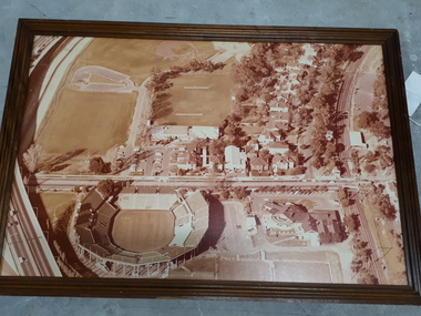
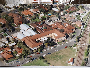
 Federation University Historical Collection
Photograph, Aerial View of the Ballarat College of Advanced Education, 1986
... aerial photograph... helen campus ballarat college of advanced education aerial ...Black and white photograph of the Mount Helen Campusmount helen campus, ballarat college of advanced education, aerial photograph, student residences -
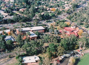 Eltham District Historical Society Inc
Photograph, Aerial view of Eltham Shire Office and Eltham Library precinct, 1994, 1994
... aerial photograph...Colour photograph of oblique aerial view centred on Eltham... photograph Colour photograph of oblique aerial view centred on Eltham ...Colour photograph of oblique aerial view centred on Eltham Shire Offices, 1994eltham shire office, eltham library, main road, eltham, aerial photograph -
 Orbost & District Historical Society
black and white photographs, 1980s? (winter months)
... Orbost-township-1980s aerial-photograph-Orbost... towards Bete Bolong. These photographs are detailed pictorial ...All photographs seem to have been takenfrom the Telecom tower on the corner of Browning and Wolseley Streets in Orbost 3259.1 is a view of the Orbost township looking north-east. The swimming pool and bowling club can be seen in the foreground. 3259.2 is aview looking north-west and showing the tennis courts and clubhouse, the Recreation Reserve oval, the Youth Centre, Historical Museum, Municipal Offices, Senior Citizens clubrooms with the fire station in the foreground. 3259.3 is a view looking south with the Shire of Orbost Municipal offices and Ruskin Street in the foreground. Munro Street can be seen running from Ruskin Street to St Joseph's School in the middle distance. Lochiel Park oval, Lochiel House, the Snowy River and highway bridge are in the background. 3259.4 is a view looking south showing the Club Hotel, C.B.C. Bank in the middle distance and Hoffman's paddock (Forest Park) and the Snowy River beyond. 3259.5 is a view looking north-east over houses. 3259.6 is aview over the main street, Nicholson Street.showing the main shopping precinct. Shop signs for Permewans, Williams Shoes, F.B. Dicken and Orbost Bakery can be seen. 3259.7 is a view looking south west and shows Forest park and beyond towards Bete Bolong.These photographs are detailed pictorial records of the township of Orbost.Seven black / white photographs taken from above a township. Chimney smoke can be seen in the photographs.orbost-township-1980s aerial-photograph-orbost -
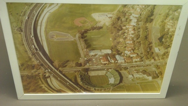
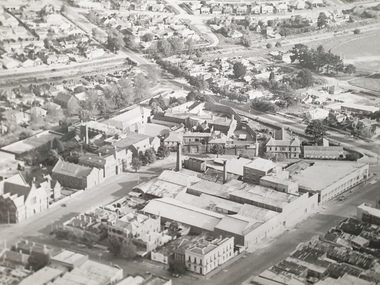 Federation University Historical Collection
Photograph - Photorgraphs - Black and White, Aerial Photographs around the Ballarat School of Mines, Pre 1967
... aerial photograph... garden, Manchester Unity Hall Aerial Photographs around ...Ballarat School of Mines is in Lydiard Street South, in close proximity to White Flat oval. 3821.1 & .2 - Black and white photograph taken from an aeroplane over Ballarat. Shows Ballarat School of Mines, Ballarat Gaol, Ballarat Girls' Technical School, gasometers, White Flat, Yarrowee Channel. 8251.3 & .4 & .5 - Black and white photograph taken from an aeroplane over Ballarat. Shows Ballarat School of Mines, Ballarat Gaol, Ballarat Junior Technical School, Albert Street, Gaol garden, Manchester Unity Hall ballarat school of mines, aerial photograph, hickman street, white flat oval, former ballarat gaol, ballarat girls' technical school, gasometer, aeroplane, white flat, armstrong street south, ballarat gaol, manchester university hall -
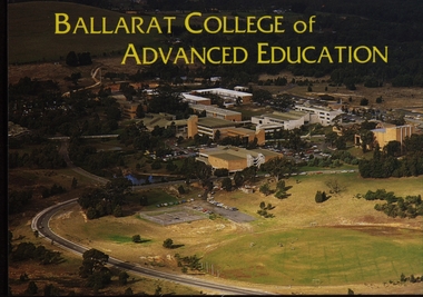 Federation University Historical Collection
Postcard - Colour, Ballarat College of Advanced Education Aerial View, c1980, c1980
... aerial photograph... photograph Colour photographic postcard of an aerial view ...Colour photographic postcard of an aerial view of the Ballarat College of Advanced Education (now Federation University) campus at Mount Helen. ballarat college of advanced education, mt helen campus, aerial photograph -
Clunes Museum
Map - DOCUMENTS/MAP, 3 1887. .4 1891
... AERIAL PHOTOGRAPH... AERIAL PHOTOGRAPH MINE SECTIONS .1 ON BACK. CLUNES 1:25000 .2 ...MINING, CLUNES GOLD MINES, MAPS, SECTIONS.1 AERIAL VIEW OF CLUNES AND DISTRICT. COLOUR PHOTOGRAPH LAMINATED. .2 MAP OF MINING AREAS SHOWING EXCISED AREA. No. 9104. MINING DISTRICT OF BALLARAT. PARISH OF CLUNES. COUNTY OF TALBOT. SCALE 4 CHAINS TO AN INCH. .3 MAP OF GOLD MINING LEASE BLOCKS AT CLUNES .4 DRAWINGS OF SECTIONS, CLUNES GOLD MINES. SCALE 400 FEET TO AN NCH. ALL MOUNTED WITH PLASTIC HANGING STRIPS..1 ON BACK. CLUNES 1:25000 .2 ASSORTED HANDWITTEN NOTATIONS. .3 ASSORTED HANDWITTEN NOTATIONS. REPLACE IN DEPT. OF MINING REGISTRARS QUARTER ENDED 30TH JUNE 1887. P. 12.clunes, gold mining, leases, aerial photograph, mine sections -
 Ballarat Heritage Services
Photograph - Digital photographs, L.J. Gervasoni, Kew and Hawthorn from the air, c2017
... aerial photograph... melbourne aerial cityscape landscape kew yarra river aerial ...Digital images of the Melbourne suburb od Kew and Hawthorn from the air.hawthorn, camberwell, kew junction, eastern freeway, camberwell junction, glenferrie, kew cottages, willsmere, melbourne, aerial, cityscape, landscape, kew, yarra river, aerial photograph -
 Bayside Gallery - Bayside City Council Art & Heritage Collection
Photograph - type C photograph, Newmark Aerial Photography, Kamesburgh, North Road, Brighton, 1996
... Kamesburgh North Road Brighton Historic House Aerial Photograph ...kamesburgh, north road, brighton, historic house, aerial, photograph, newmark aerial photography, anzac hostel, william kerr thomson, lloyd tayler, italianate, streets -
 Bayside Gallery - Bayside City Council Art & Heritage Collection
Photograph - type C photograph, Newmark Aerial Photography, Billilla, Halifax Street, Brighton, 1996
... brighton historic house aerial photograph newmark aerial ...brighton, historic house, aerial, photograph, newmark aerial photography, streets, billilla, weatherly, william weatherly, smith and johnson, walter richmond butler, halifax street -
 Bayside Gallery - Bayside City Council Art & Heritage Collection
Photograph - type C photograph, Newmark Aerial Photography, Brighton Town Hall, Wilson Street, Brighton, 1996
... brighton aerial photograph newmark aerial photography streets ...brighton, aerial, photograph, newmark aerial photography, streets, brighton town hall, brighton library, brighton court house, court house, library, gardens, wilson street, carpenter street, boxshall street, khyatt's hotel, council chambers, brighton police station -
 Moorabbin Air Museum
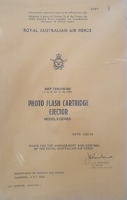
Manual (Item) - (SP) AAP 7336.010-3M Photo Flash Cartridge Ejector Model 9 Series
... night aerial photograph... aerial photograph Manual (SP) AAP 7336.010-3M Photo Flash ...Royal Australian Air Force Air publication issued in July 1976 covering photo flash cartridge ejector model 9 series. royal australian air force, photo flash cartridge ejector, night aerial photograph -
 Lakes Entrance Historical Society
Photograph - Lakes Entrance, 1945c
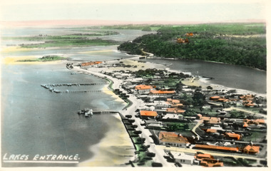
... Aerial Photograph... Aerial Photograph Waterways Township Lakes Entrance Black ...Two tinted copies, one 8.5 x 13.5 and one 6.5 x 9Black and white postcard showing town, twelve memorial cypress trees and spotting tower on foreshore, post office wharf, boat harbour, Club Hotel at west end of esplanade with five palm trees opposite, causeway to Bullock Island, highway bridge over North Arm, highway up to Jemmys Point, Rigby, Fraser and Flannagan Island's towards Metung. Lakes Entrance VictoriaLakes Entrance islands, aerial photograph, waterways, township -
 Lakes Entrance Historical Society
Photograph - Lakes Entrance, 1975c
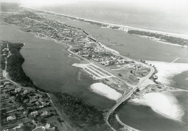
... Aerial Photograph...Black and white photograph of an aerial view of township...Aerial Photograph Topography Township Black and white ...Black and white photograph of an aerial view of township and Kalimna Heights, showing the North Arm bridge and boat ramp, sand buildup in the lake system, boat harbour, sand hummocks and beach as far as Red Bluff. Lakes Entrance Victoriaaerial photograph, topography, township -
 Lakes Entrance Historical Society
Photograph - Lakes Entrance, 1997
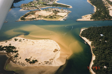
... Aerial Photograph...Colour photograph being an aerial view of the western end...Date made 7 July 1997 Topography Waterways Aerial ...Date made 7 July 1997Colour photograph being an aerial view of the western end of Cunninghame Arm, showing the entrance between the hummocks, Bullock Island, entrance to North Arm, Snake Island surrounded by sand build-up. Lakes Entrance Victoriatopography, waterways, aerial photograph, boats and boating, township, islands -
 Lakes Entrance Historical Society
Photograph - Whiter's Camp Park, Bulmer H D, 1935
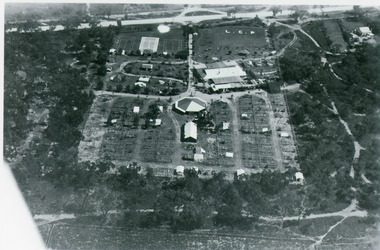
... Aerial Photograph...Tourism Resort Aerial Photograph Camping Black and white ...Black and white aerial view of Whiters Camp Park, looking south to Roadknight Street. Shows layout of camping facilities, including sites, tennis courts, rotunda, and family home which incorporated shop with all requirements for a holiday. Lakes Entrance Victoriatourism, resort, aerial photograph, camping -
 Lakes Entrance Historical Society
Postcard - Backwater, Bulmer H D, 1922c
... Aerial Photograph...Islands Aerial Photograph Waterways Topography Township ...Black and white photographic postcard, showing early aerial view of township of Lakes Entrance, Cunninghame Arm, North Arm and sand dunes, ocean in lower foreground, Eastern wharf and various boats on lake. Princes Highway went along Esplanade, Myer Street and Roadknight Street, very little vegetation on sand dunes, no foot bridge yet, good view of North Arm, few houses. Lakes Entrance VictoriaLakes Entrance and Backwater from the Air.islands, aerial photograph, waterways, topography, township