Showing 2513 items
matching aerials
-
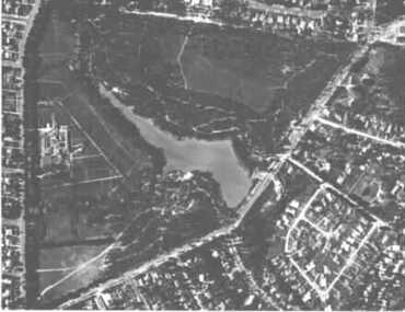
 Tatura Irrigation & Wartime Camps Museum
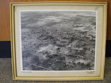
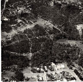
Photograph, Aerial Photograph, Jan-59
Framed enlarged aerial photograph of Tatura, January 1959.Tatura Jan 1959tatura, photography, photograph, slides, film -
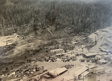
 Stawell Historical Society Inc
Photograph, B/W Aerial Photograph of Pleasant Creek Training Centre & Stawell Woolen Mills C 1960's, 1960's
A3 Sized Aerial Photo on blue backing board.education, manufacturing -
 Stawell Historical Society Inc
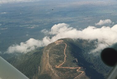
Slide, Ian McCann, Aerial View of Mt Willaim, 1960's
Aerial View of Mt William showing the roadway to the summit grampians, mt willaim -
 Stawell Historical Society Inc
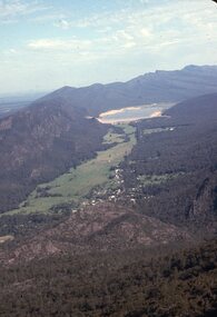
Slide, Ian McCann, Aerial View of Lake Bellfield, 1960's
Aerial View of Lake Bellfield looking up the valleylake bellfield, grampians -
 Whitehorse Historical Society Inc.
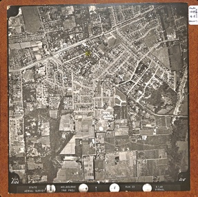
Photograph, Aerial View of Vermont, 1968
Black and white Aerial View of Vermont. Mounted on Board.gray, andrew -
 Whitehorse Historical Society Inc.
Photograph - Aerial Photograph, Aerial View of Blackburn Lake, C.1960s
Black and white photo of Aerial View of Blackburn Lake.aerial photographs, blackburn lake -
 Whitehorse Historical Society Inc.
Photograph, Aerial View of Vermont and surrounding area
3 Copies of Aerial View of Vermont and surrounding area.vermont, arial view -
 Rutherglen Historical Society
Photograph - Aerial Images, c2000
View is of the rear of St Mary's Catholic Church, RutherglenColour aerial photograph of the rear of the Catholic Church in Rutherglenst marys church, church buildings, churches -
Clunes Museum
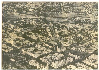
Postcard - POST CARD
POSTCARD SHOWING AN AERIAL VIEW OF STURT STREET BALLARATTOM FROM SISTER MARYlocal history, postcards -
 Falls Creek Historical Society
Photograph - Aerial View of Bogong Alpine Village
The images in the Bogong Village Collection were displayed in Bogong Jack’s Tavern for over 20 years and were donated to the Falls Creek Museum when the Tavern closed in 2021. In 1939, the State Electricity Commission of Victoria established a field headquarters at Bogong to house workers and their families for the Kiewa Hydroelectric Scheme which ran from the 1930s to the 1960s. The workmen's camp was originally started with tents and was called Junction Camp. By 1947, the village supported 300 workers and their families. It included 40 houses, a hostel for single staff, a post office, a police station, a medical centre, and a primary school. The staff hostel was known as Kiewa House. At the completion of the Scheme, in the 1960s, the village was opened to public/tourism use. In 1968 the Victorian Education Department acquired the camp buildings and four houses from the State Electricity Commission of Victoria to establish an Outdoor Education Centre which operated for over 50 years. The Kiewa Hydroelectric Scheme was privatized in the 1990s and sold to Southern Hydro, before being acquired by AGL in 2005. In 2023 the Grollo Group signed a 73 year sublease on Bogong Village and has plans for its redevelopment as a workers’ village.These images are significant because they capture the development of Bogong Village as an important element of the Kiewa Hydroelectric Scheme in Victoria.An aerial view of Bogong Village and surrounds, date unknown.bogong alpine village, bogong high plains, aerial photos bogong village -
 Whitehorse Historical Society Inc.
Photograph - Aerial Photograph, Bushland Yarran Dheran
Aerial photos of Yarra Dheran including Mitcham and Donvale.mitcham, donvale, yarra dheran -
 Ballarat and Queen's Anglican Grammar School
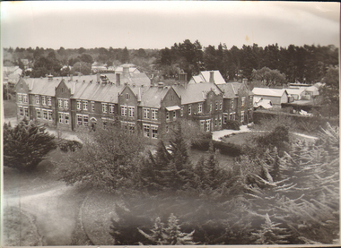
b&w Photograph, Aerial photograph of School buildings
Aerial photograph of school buildings with large trees in foregroundVerso - N. L. HARVEY (Press Photo Service) A.M.P. Chambers Lydiard St. N. 2999 pencilled on versoballarat-grammar, wendouree, education -
Moorabbin Air Museum
Document (Item) - RAAF Air Power Studies Centre , Paper Number 46, RAAF Air Power Studies Centre
An Extended Role For Unmanned Aerial Vehicles In The RAAF By WC M.Lax & WC B.Sutherland -
 Bendigo Historical Society Inc.
Map - BENDIGO MAP AERIAL VIEW, 1890s
Map of Bendigo. Aerial View of Bendigo. This aerial photograph was taken specially to mark the pccasion of the United Country party conference of 1936. Issued with the complements of 'The Argus' April 1936.photograph, aerial, bendigo -
 Bayside Gallery - Bayside City Council Art & Heritage Collection
Photograph, Department of Crown Lands and Survey, Victoria, Melbourne Project: Brighton and Hampton, 1976
The Department of Crown Lands and Survey (1857-1983) was responsible for the administration of survey and mapping and the sale, occupation and management of crown land throughout its existence. This aerial photograph shows parts of Brighton and Hampton and was taken on 1 December 1976. brighton, department of crown lands and survey, aerial photograph, bayside, port phillip bay, map, cartographic material, melbourne project 1976, brighton yacht club, middle brighton baths, hampton, green point, brighton beach, south road, the esplanade, hampton street -
Whitehorse Historical Society Inc.
Document, 520 Mitcham Road, 2005
Papers relating to objections to development of 520-528 Mitcham Road Mitcham.Papers relating to objections to development of 520-528 Mitcham Road Mitcham. Includes: statement by Neil Edwin Kerby & Margaret Anne Kerby; Title searches for 449 Mitcham Road Mitcham and adjacent properties; plan of 1906 subdivision; ASIC extract of development company organisational details; aerial photos of the area; photographs of nearby properties and of Mitcham Road streetscapes and list of Mitcham objectors. CD copy at NP3771Papers relating to objections to development of 520-528 Mitcham Road Mitcham. mitcham road mitcham, nos. 520-528, kerby, neil edwin, kerby, margaret anne, mitcham road mitcham no. 449, 520 mitcham road pty ltd, listermay nominees pty ltd, land subdivision -
 Bayside Gallery - Bayside City Council Art & Heritage Collection
Photograph, Department of Crown Lands and Survey, Victoria, Melbourne Project: Brighton, Hampton, Sandringham, 1976
The Department of Crown Lands and Survey (1857-1983) was responsible for the administration of survey and mapping and the sale, occupation and management of crown land throughout its existence. This aerial photograph shows parts of Brighton, Hampton and Sandringham and was taken on 1 December 1976brighton, department of crown lands and survey, aerial photograph, bayside, port phillip bay, map, cartographic material, hampton, sandringham, green point, sandringham yacht club, south road, beach road, hampton street, melbourne project 1976 -
 Melbourne Tram Museum
Drawing, Melbourne & Metropolitan Tramways Board (MMTB), Aerial photographs Bundoora Tram Extensions, Plenty Road – MMTB Drawings – 12/1979, Bundoora Extension – Metropolitan Transit Authority – 2/1983, John-Connell – Mott Hay and Anderson – Preliminary drawings for the Latrobe Modal Interchange – August 1984, 1979 to 1984
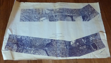
Set of drawings for the MMTB Plenty Road extension in 1979, MTA extension to Bundoora in 1983 and the Latrobe Uni Modal Interchange - 1984. Large print – Aerial photographs Bundoora Tram Extensions Stage 2 – Albert St to Kingsbury Drive Stage 3 – Kingsbury Drive to Settlement Road Has been rolled, left hand edge damaged, right hand edge torn Compiled by the ROW Division – 2/1981. Has written on rear at right hand end “Bundoora Tram Extension – Official MMTB Plans” 760H x 1190W Plenty Road – MMTB Drawings – 12/1979 P15123 Tyler St to Walsal Avenue P15124 Walsal Ave t McColl St P15125 McColl St to Dorrington Avenue Bundoora Extension – Metropolitan Transit Authority – 2/1983 P15400 Dorrington Avenue to Barwon Avenue P15401 Barwon Avenue to Nicholson Ave P15402 Nicholson St to Barling Park P15403 Barling Park to Darebin Creek P15404 Darebin Creek to Scott Grove P15405 Scott Grove to Clunes Street P15406 Clunes St to Cash St P15408 Cash St to Bundoora Park P15409 Bundoora Park to Larundel Hospital P15410 At Larundel Hospital P15411 Larundel Hospital to Marne Court P15412 Marne Court to Cherrywood Court P15413 Cherrywood Court to Morwell Ave P15414 Morwell Ave to Grimshaw St P15415 Grimshaw St to Nickson Street P15416 Nickson St to McLeans Road John-Connell – Mott Hay and Anderson – Preliminary drawings for the Latrobe Modal Interchange – August 1984. 8094-A-20 Set Out Plan and Paving Details 8094-A-21 Elevations 8094-A-22 Sections 8094-A-23 Roof Plan and Stormwater Layout 8094-A-24 Canopy Details 8094-A-25 Toilet Block and Waiting Room 8094-A-28 Miscellaneous DetailsOn rear of aerial photograph sheet - at right hand end “Bundoora Tram Extension – Official MMTB Plans” in felt pen.trams, tramways, plenty rd, bundoora, latrobe university, mmtb, construction, mta -
 Bayside Gallery - Bayside City Council Art & Heritage Collection
Photograph, Department of Crown Lands and Survey, Victoria, Melbourne Project: Brighton and Elwood, 1976
The Department of Crown Lands and Survey (1857-1983) was responsible for the administration of survey and mapping and the sale, occupation and management of crown land throughout its existence. This aerial photograph shows parts of Brighton and Elwood and was taken on 1 December 1976brighton, elwood, department of crown lands and survey, aerial photograph, elsternwick park, point ormond, north road, ormond esplanade, st kilda street, glen huntly road, bayside, port phillip bay, map, cartographic material, melbourne project 1976 -
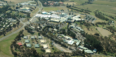 Federation University Historical Collection
Photograph, Aerial View of Gippsland Campus South View
Colour photograph of an aerial view of Gippsland Campus (South View)churchill campus, gippsland campus, binishell, student residences -
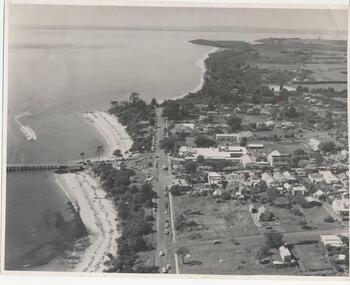 Phillip Island and District Historical Society Inc.
Photograph, Payens' Photographic Services, 1950's
Photograph donated by Jean Bain.Black & White aerial view of Cowes township, foreshore and jetty.aerial view cowes phillip island, cowes phillip island -
Phillip Island and District Historical Society Inc.
Postcard
This Postcard came from the Estate of Keith McIlwraith on 20th July 1983.Aerial view of Cowes, Phillip Island, from the north-east.local history, documents, postcards, early postcards, postcard, cowes, phillip island -
Phillip Island and District Historical Society Inc.
Photograph, ?
Part of collection of Photographs donated to the Museum by The Family of late Mr. Jack Jenner (1977).Sepia Postcard - Valentine Series - Aerial view of Cowes & Pier.View of Cowes, Phillip Island, from the air. Valentine Series No. 1616.local history, photography, photographs, slides, film, view cowes, sepia photograph, jack jenner, aerial view cowes, valentine series -
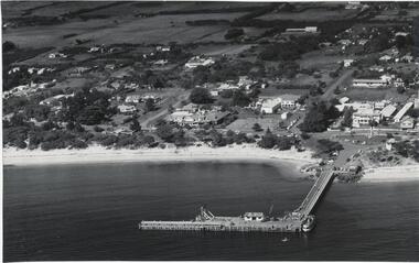 Phillip Island and District Historical Society Inc.
Photograph, Bryant West
One of a collection of over 400 photographs in an album commenced in 1960 and presented to the Phillip Island & Westernport Historical Society by the Shire of Phillip Islandaerial photograph, part of Cowes Township and beach with Jetty in foregroundlocal history, photography, photographs, part cowes township - cowes beach and jetty, cowes township, beach, jetty, john jenner, bryant west -
 Phillip Island and District Historical Society Inc.
Photograph, Bryant West
One of a collection of over 400 photographs in an album commenced in 1960 and presented to the Phillip Island & Westernport Historical Society by the Shire of Phillip IslandAerial Photograph of Phillip Island Bridge - Newhaven to San Remo.local history, photography, photographs, civil engineering, bridges, bridge, newhaven, san remo, phillip island, coastline, suspention bridge phillip island, john jenner, bryant west -
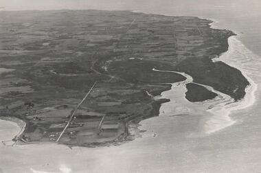 Phillip Island and District Historical Society Inc.
Photograph, Bryant West
One of a collection of over 400 photographs in an album commenced in 1960 and presented to the Phillip Island & Westernport Historical Society by the Shire of Phillip IslandAerial Photograph of Northern Coastline of Phillip Island with Rhyll in the foreground.local history, photography, photographs, northern coastline, phillip island, rhyll, coastline, cowes, john jenner, bryant west -
 Greensborough Historical Society
Letter, Restoring the natural beauty at Pioneer Reserve, 21/05/2019
Letter to residents, outlining plans to renovate Pioneer Reserve Greensborough by introducing native vegetation and returning it to a more natural state. This includes removing the toilets, picnic shelter and playground.2 p. letter, coloured aerial photograph on back pagepioneer reserve greensborough, banyule council -
Glenelg Shire Council Cultural Collection
Photograph - Photograph - Cape Grant and Quary, n.d
Port of Portland Authority Archivesport of portland archives, cape grant -
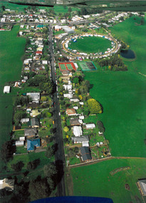 Poowong Historical Group
Aerial Photos of Poowong Township 200?
Aerial photograph of poowong Football Groung looking North East -
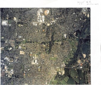
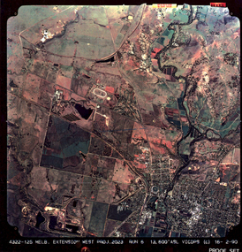 Federation University Historical Collection
colored aerial photograph, Melb. Extension West Project, 2023
13323.1, 13323.2, 13323.3 colored typographical aerial photographs, encapsulatedprinted "Melb. Extension West Proj. 2023..."