Showing 513 items
matching black forest
-
 Melbourne Legacy
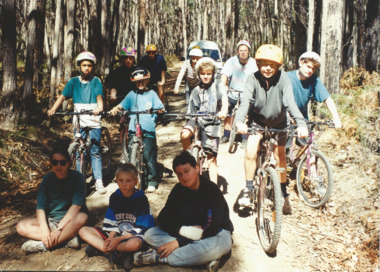
Photograph - Junior legatee outing, Youth Camp at Beaufort 1995, 1995
Photographs of Junior Legatees doing outdoor activities. Melbourne Legacy arranged many events for Junior Legatees to experience. One photo has 12 children on bicycles in a forest. Another has four children in kayaks playing and having a water fight with their paddles. Another photo has a young child with a supervisor getting ready for abseiling. Names are unknown. It was with a group of photos from the 1990's in a folio with paper labels. The article in The Answer explains it was a the annual two week summer camp for Junior Legatees. In 1995 it was held at Cave Hill Creek, near Beaufort and the nearby Mt Cole State Forest. The children were supervised by a team of 12 experienced leaders from the Melbourne Legacy Leadership group assisted by educational instructors. A total of 50 attended the camp (27 boys and 23 girls). Most came from Melbourne but some from country Victoria and 9 from South Australia. A record of events run for Junior Legatees by Melbourne Legacy.Colour photo x 3 of junior legatees on bikes, in kayaks and abseiling and an article in the Answer about the youth camps.White paper label: "Junior Legatees participate in a wide range of recreational activities" in black type.junior legatee outing, answer, camp -
 Forests Commission Retired Personnel Association (FCRPA)
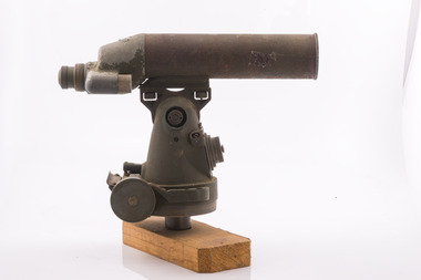
Telescope used in FCV fire towers - ex military, c 1940s
Victoria once had well over one hundred fire lookouts and firetowers. Fire lookouts, or observation posts, were often just a clearing on a hill or a vantage point, whereas firetowers were definite structures. Many were established by the Forests Commission Victoria (FCV) in the 1920s, but the network was expanded rapidly in response to recommendations of the Stretton Royal Commission after the 1939 Black Friday bushfires. When a fire or smoke was spotted from the tower a bearing was taken with the alidade and radioed or telephoned into the district office. It was then cross referenced with bearings from other towers on a large wall map to give a "fix" on the fire location Alidades and telescopes were used in the post war period but were replaced with a much simpler map table and reference string suspended from the centre of the tower cabin.Uncommon usageTelescope used in fire towers Ex military Kern Company NY Argus made in USA Adjustment lens, dials and focus ring Small spirit levelbushfire, forests commission victoria (fcv) -
 Forests Commission Retired Personnel Association (FCRPA)
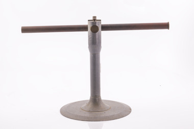
Alidade - sight tube used in FCV fire towers, c 1940s
Victoria once had well over one hundred fire lookouts and firetowers. Fire lookouts, or observation posts, were often just a clearing on a hill or a vantage point, whereas firetowers were definite structures. Many were established by the Forests Commission Victoria (FCV) in the 1920s, but the network was expanded rapidly in response to recommendations of the Stretton Royal Commission after the 1939 Black Friday bushfires. When a fire or smoke was spotted from the tower a bearing was taken with the alidade and radioed or telephoned into the district office. It was then cross referenced with bearings from other towers on a large wall map to give a "fix" on the fire location Alidades and telescopes were used in the post war period but were replaced with a much simpler map table and reference string suspended from the centre of the tower cabin.Uncommon usageAlidade Sight TubeFCV and bearing markers on the alloy base. Very simple design. bushfire, forests commission victoria (fcv) -
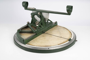
 Department of Energy, Environment and Climate Action
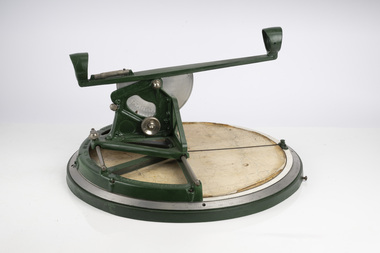
Fire Finder
Victoria once had well over one hundred fire lookouts and firetowers. Fire lookouts, or observation posts, were often just a clearing on a hill or a vantage point, whereas firetowers were definite structures. Many were established by the Forests Commission Victoria (FCV) in the 1920s, but the network was expanded rapidly in response to recommendations of the Stretton Royal Commission after the 1939 Black Friday bushfires. When a fire or smoke was spotted from the tower a bearing was taken with the alidade and radioed or telephoned into the district office. It was then cross referenced with bearings from other towers on a large wall map to give a "fix" on the fire location. Alidades and telescopes were used in the post war period but were replaced with a much simpler map table and reference string suspended from the centre of the tower cabin. This "Fire Finder" was used in Canadian fire towers to identify the location of wildfires. The unique design was first developed by the British Columbia Forest Service (BCFS) in the early 1950s. Close examination of the map indicates that this particular Fire Finder may have been once used at Bluejoint Mountain lookout in Granby Provincial Park. This Fire Finder was a gift to Barry (Rocky) Marsden from the British Columbia Forest Service in the late 1980s in recognition of the close relationships that had been forged with the staff at the Altona Workshops over many decades. Fire Finders were originally painted black but this one was repainted green after it arrived at Altona. The BC Forest Service had a large facility where they manufactured Fire Finders and many other items of equipment, but in the 1980s it was shut down. Heavy cast iron circular object with a paper topographic map mounted on it. The metal dial and ruler works similar to a compass. The sight tube is used to determine the bearing and elevation of the fire on the map. This Fire Finder also sometimes known as an Alidade. Its a different design from the Osborne Fire Finder widely used in North American fire lookouts from the 1920s. British Columbia Forest Service. Model 62A. Serial Number 6308.bushfire -
 Department of Energy, Environment and Climate Action
Fire Finder
Victoria once had well over one hundred fire lookouts and firetowers. Fire lookouts, or observation posts, were often just a clearing on a hill or a vantage point, whereas firetowers were definite structures. Many were established by the Forests Commission Victoria (FCV) in the 1920s, but the network was expanded rapidly in response to recommendations of the Stretton Royal Commission after the 1939 Black Friday bushfires. When a fire or smoke was spotted from the tower a bearing was taken with the alidade and radioed or telephoned into the district office. It was then cross referenced with bearings from other towers on a large wall map to give a "fix" on the fire location. Alidades and telescopes were used in the post war period but were replaced with a much simpler map table and reference string suspended from the centre of the tower cabin. This "Fire Finder" was used in Canadian fire towers to identify the location of wildfires. The unique design was first developed by the British Columbia Forest Service (BCFS) in the early 1950s. Close examination of the map indicates that this particular Fire Finder may have been once used at Bluejoint Mountain lookout in Granby Provincial Park. This Fire Finder was a gift to Barry (Rocky) Marsden from the British Columbia Forest Service in the late 1980s in recognition of the close relationships that had been forged with the staff at the Altona Workshops over many decades. Fire Finders were originally painted black but this one was repainted green after it arrived at Altona. The BC Forest Service had a large facility where they manufactured Fire Finders and many other items of equipment, but in the 1980s it was shut down. Heavy cast iron circular object with a paper topographic map mounted on it. The metal dial and ruler works similar to a compass. The sight tube is used to determine the bearing and elevation of the fire on the map. This Fire Finder also sometimes known as an Alidade. Its a different design from the Osborne Fire Finder widely used in North American fire lookouts from the 1920s. British Columbia Forest Service. Model 62A. Serial Number 6308.bushfire -
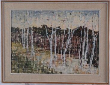 Glenelg Shire Council Cultural Collection
Painting, Renee Arendsen, Dead Wood Forest Mallacoota, 1967
CEMA Art Collection Winner of 1968 Portland Art Society Art Prize for the category Oil or similar medium.The painting depicts several tall, dead trees in the foreground with dense living trees in the background. The foreground is green, white and yellow. The work has an interesting texture created through the use of clearly defined thick paint strokes. This technique is particularly evident in the foreground where it has been used to create the ground from which the dead trees stand. The work has a painted wooden frame with material mount and non-reflective glass.Front: R. ARENDSEN '67 (black, lower right) Back: RENNEE ARENDSEN "DEAD WOOD FOREST, MALLACOOTA" (1968) (typed) Stamp: KATRINA GALLERIES 485 CENTRE ROAD BENTLEIGH, VIC 97-6715 Yellow Sticker: 1967 Handwriting around back of frame.female artists, female artist, landscape, trees -
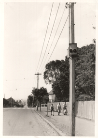
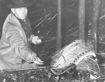 Ringwood and District Historical Society
Photograph, Les Mabus, Bedford Rd, Ringwood, feeding lyre bird in Sherbrooke Forest. c1950
... , Ringwood feeding lyre bird in Sherbrooke Forest". Black and white ...Black and white photographWritten on back of photograph: "Les Mabus, Bedford Rd, Ringwood feeding lyre bird in Sherbrooke Forest". -
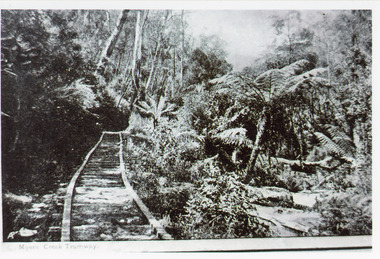 Lakes Entrance Historical Society
Photograph - Tramline, 1925
Rock obtained for works at the Entrance and around Gippsland Lakes.Black and white photograph of a tramway through bushland, steep bank above tramline, tree fern gully below. Tramway connected quarry to landing on Mississippi Creek, Colquhoun Forest north of Lakes Entrance. East Gippsland VictoriaMyer's Creek Tramwayvegetation, transport, room display -
 Ballarat Tramway Museum
Photograph - Geelong Forest City signal lights, Keith Kings, Oct. 1955
Photo shows a Forest City style signal light on a pole at the corner of Pakington St and Retreat Road Geelong, Newtown 17/10/1955. Photo by Keith Kings, Number Q(m)(3). In the background are two ladies, a young boy and pram with a young child.Yields information about the Forest City signals in Geelong on the Newtown Route.Black and white photograph with notes on rear.See Contexttrams, tramways, secv, forest city signals, signals, pakington st, retreat road -
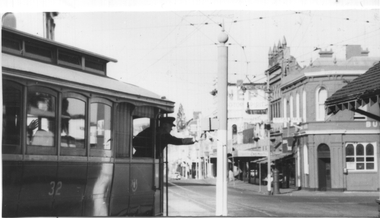 Ballarat Tramway Museum
Photograph - Grenville St signal switch, Keith Kings, 12/4/1958
Photograph shows the motorman of tram 32 selecting the correct signal light for his passage into Bridge St to either the Victoria St or Mt Pleasant Routes. Also allowed the tram to shunt at the intersection and return along Sturt St. See page 44 of the photographer's book, The Ballarat Tramways published in Sept. 1971 - item 114. Has the Buckshead Hotel in the background. Dated 12/4/1958. Yields information about the operation of the Bridge St / Grenville St signal.Black and white photograph with photographers details and information on rear - Keith Kings No. A(l)(13)See image 2ballarat, trams, tramways, sturt st, bridge st, tram 32, signals, forest city signals, grenville st -
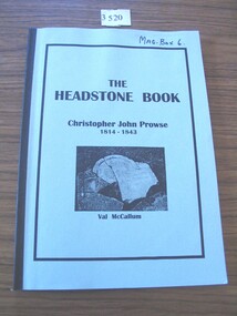 Stawell Historical Society Inc
Book, Val McCallum, The Headstone Book - Christopher John Prowse 1814-1843, 1995
Specially prepared for release at a ceremony on 9th April 1995, to mark the restoration of the historic headstone and placement in Dowling Forest Cemetery during the 1995 Victorian Heritage festival.Medium blue cad with black tape on spine. inset black border with the Title and sub title B/W Photo of Broken gravestone above Author NameThe Headstone Book Christorpher John Prowse 1814-1843 Val McCallum Inside: With best wishes Val McCallumstawell -
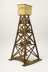 Forests Commission Retired Personnel Association (FCRPA)
Wooden Model Fire Tower, Tom Coish, Model of Reef Hills fire tower, (5 km south of Benalla), 1957
Victoria once had well over one hundred fire lookouts and firetowers. Fire lookouts, or observation posts, were often just a clearing on a hill or a vantage point, whereas firetowers were definite structures. There are at least three categories of firetowers… (1) tree perches, (2) four-legged towers made of either wood or steel, as well as (3) hilltop cabins and observatories. Many were established by the Forests Commission Victoria (FCV) in the 1920s, but the network was expanded rapidly in response to recommendations of the Stretton Royal Commission after the 1939 Black Friday bushfires. The wooden towers were often built by bush craftsmen like legendary FCV overseer Clem Heather from Orbost. But advances in aerial reconnaissance and radio technology led to the gradual reduction in the number of fixed towers. FFMV now operates 72 firetowers. The CFA, Melbourne Water, Hancock Victorian Plantations (HVP) also operate some, the Army has one at Puckapunyal overlooking the live-firing range. Only two remaining fire towers of this design remain in Victoria (Mt Little Dick and Big Tower in the Mullungdung State Forest). Mt Nowa Nowa and Stringers Knob burnt down in the 2019/20 bushfiresLarge model of an Reef Hills fire tower. Presumably used for instructional purposes. Traditional FCV four legged design with three landings and closed cabin.bushfire, forests commission victoria (fcv) -
 Warrnambool and District Historical Society Inc.
Booklet - Warrnambool Visitor's Handbooks 1979-2024, Collett, Bain and Gaspar, Printers, 1979-2014
This is a collection of eight Warrnambool Visitor handbooks produced between 1979 and 2014 by the City of Warrnambool Tourist Information Centre. They contain maps of Warrnambool, lists of services, accommodation and tourist attractions as well as many advertisements for local businesses.These handbooks give a useful snapshot of businesses and tourist attractions in Warrnambool for each of the years covered. (1979, 1980, 1986, 1990, 1993, 1994, 1995, 2014)[.1a] A 48 page booklet with white pages and blue printing. The front cover has a coloured photograph of Flagstaff Hill with boats on a man made lake in the foreground looking across Lake Pertobe toward South Warrnambool. [.1b] A coloured bifold brochure. The front cover has a fisherman on a cray-boat holding a crayfish in the lower section. The top quarter has a blue back ground with white printing. The rear cover is red and has small photos of the Hopkins River and the Framlingham Forest. [.2] A 48 page booklet with white pages and black printing. The front cover is white with black writing on the left hand side and a colour photograph of the Loch Ard peacock. The Warrnambool Premier Town stylised logo of seven Norfollk pines above blue waves is in the top right hand corner. There is a blank ink Warrnambool Library stamp underneath the logo. The rear cover has photographs of The Twelve Apostles and the Hopkins Falls and the Premier Town Logo [.3] A 40 page booklet with mainly black printing on white paper. There are three fold out maps of Warrnambool and the surrounding district. The glossy cover has a black background with a colour photograph of the Twelve Apostles taken at sunset. The rear cover has three small of Proudfoot's boathouse on the Hopkins River, Flagstaff Hill, and the main beach area. The front cover has black writing inside to peach coloured rectangles. The inside rear cover has a fold out coloured tour map of Western Victoria. [.4] A 40 page booklet printed on glossy white paper with coloured photographs and black and red printing. The front cover has a photograph of The Twelve Apostles surrounded by a white border. There is red writing in the upper border. There is a sandy coloured writing superimposed across the bottom of the photograph and a Victoria's Shipwreck Coast logo in the bottom right hand corner. [.5] A 44 page booklet printed on white paper with black printing. The cream coloured cover has a pale red rectangle with blue writing on the right hand facing edge and includes two stylised Norfolk pines and with waves underneath. There is is an intersecting blue rectangle with cream printing. [.6] A 48 page booklet printed on white paper with black printing. The cover is brown with a cream vertical strip containing black writing on the right hand side. There is a stylised map from Geelong to Mount Gambier showing the Great Ocean Road across the cover. [.7] A 48 page booklet printed on white paper with black print. The glossy colour cover has a photograph of a Southern Right whale fluke. There is white printing on a the blue background of the sky and sea. The bottom left hand side of the front cover has a Tourism Victoria logo made of jigsaw puzzle pieces. The back cover has a stylised coloured map of The Great Ocean Road located in a white rectangle at the top of the page. Within the rectangle is a small map of Australia locating Victoria and the part of Victoria covered by the map. [.8] A 64 page A5 coloured booklet printed on white pages with black print. The white front cover has black and grey print with a colour photograph of two people holding coffee cups watching four race horses being exercised on the beach and in the water of Lady Bay in the early morning. The bottom right hand corner has a Tourism Victoria logo. The rear cover has a mainly blue back ground with a pink orange and green colour splats contains words advertising the 2015 Fun 4 Kids Festival [.1a] Warrnambool The Heart of Victoria's Great Southwest Visitor's Handbook [.1b] Warrnambool City for all seasons; The Heart of Victoria's Great Southwest [.2] Warrnambool visitor's handbook Warrnambool Premier Town 1979-1982 [.3] Warrnambool Handbook Victoria [.4] Warrnambool The Shipwreck Coast [.5] Welcome to Warrnambool Warrnambool Visitors Handbook 1993-1994 [.6] Welcome to Warrnambool Visitors Handbook 1994-95 Rear cover: Warrnambool Centre of Victoria's Shipwreck Coast on Australia's Great Ocean Road [.7] Warrnambool Shipwreck Coast - Great Ocean Road; You'll love every piece of Victoria; Visitors Handbook [.8] Warrnambool Great Ocean Road Official Visitor Guide; It's a wonderful Warrnambool; You'll love every piece of Victoria visitvictoria.com. Rear Cover Live entertainment.Workshops.Creativity.Action 28 June - 5 July 2015 Australia's Best Children's Festival F4K The ultimate winter school holiday adventure Fun 4 kids festival Warrnambool For more information visit Fun4kids.com.au Warrnambool great Ocean Road Victoriawarrnambool, visitor handbooks, tourist information guides, warrnambool maps -
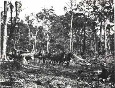 Linton and District Historical Society Inc
Photograph, W.M. Grigg in Coolgardie, circa 1896
Black and white copy of original photograph showing a team of horses hauling logs out of a forest."Mr Wm. Grigg (senrs) team hauling timber - Coolgardie C. 1896."w m grigg, western australia, coolgardie, logging -
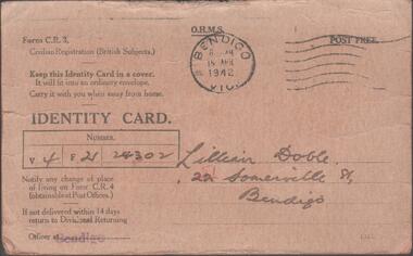 Bendigo Historical Society Inc.
Document - LILLIAN DOBLE COLLECTION: CIVILIAN REGISTRATION IDENTITY CARD LILLIAN DOBLE
Tan coloured card, black print. Civilian Registration British Subjects, Identity Card, issued to Lillian Doble, 51 Somerville Street, Bendigo. Signed: Lillian Doble, Cockings, Pall Mall, Bendigo. Witness: Doris M. Forbes, 184 Forest Street, Bendigo. Stamp on front of card: 'Bendigo 15 April 1942' Regulations re card printed on back.government, federal, civilian registration card -
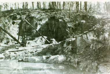 Lakes Entrance Historical Society
Photograph - Colquhoun Quarry, 1930c
Black and white photograph of the granite quarry in the Colquhoun forest to the north. The stone was used to reconstruct the piers at the entrance from 1910 to 1930. Lakes Entrance Victoria public works, historic site -
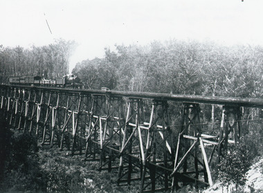 Lakes Entrance Historical Society
Photograph - Bridges, 1930
Also similar black and white copy 15 x 22 cmBlack and white photograph showing the trestle bridge over Stoney Creek near Nowa Nowa, shows Bairnsdale to Orbost train on left end of bridge. Train has four open goods trucks, two covered goods trucks, one louvred van and one passenger carriage, and guards van at rear. Tall forest in background, low scrub in front. Nowa Nowa Victoria.bridges, transport -
 Eltham District Historical Society Inc
Photograph - Digital Photograph, Alan King, Kinglake National Park, 27 March 2008
Fern gullies around Jehosaphat Gully Covered under National Estate. Published: Nillumbik Now and Then / Marguerite Marshall 2008; photographs Alan King with Marguerite Marshall.; p125 The magnificent Kinglake National Park, fringing Nillumbik’s north, is the largest national park close to Melbourne. Thanks to the vision and hard work of a band of local people, the park was created from what was rapidly becoming degraded land. Seeing a threat to Kinglake’s indigenous flora and fauna, several prominent local people campaigned for a national park, which was established in 1928.1 Since then, the park has grown through donations and acquisitions of land, from around 13,800 acres of land (5585ha) to 22,360 hectares. The Sugarloaf and Everard Blocks – of almost 8000 hectares – stand in Nillumbik and the park extends into Mitchell and Murrundindi Shires and the City of Whittlesea. Mt Everard commemorates William Hugh Everard, State member for Evelyn when the park was established. Before 1928, European settlers had degraded the Kinglake area, which was named after the celebrated English author and lawyer, Alexander William Kinglake. Remains of gold shafts and diggings in the park are reminders of Kinglake’s first settlers, who hoped to strike it rich at the gold diggings. But like other gold fields in this shire, they proved not very lucrative and soon timber cutting replaced mining in importance. However, before long, the accessible timber supply ran out, so in the 1920s agriculture took over – particularly potatoes and berry fruits – which involved large-scale clearing.2 The park’s instigator was retired Melbourne University Professor of Music, William Laver.3 As chair of the Kinglake Progress Association he began negotiations to have crown lands on the southern scarp of the Great Dividing Range reserved as a national park. Even before the park was proclaimed, from 1927, KPA members cut tracks to the major scenic points. Professor Laver was one of several people who gave land for the park, donating around 50 acres (20ha), including the Jehosaphat Gully.4 Laver chaired the park’s first Committee of Management, which raised money to employ a ranger and provide facilities, including tracks and roads for fire protection vehicles, toilets and shelters. The committee charged fees for firewood collection, some grazing of livestock, and visitor entrance, and obtained small State Government and Eltham Shire grants. In 1957 the State Government provided revenue for national parks. Then, in 1975, the State Government took over the management and the Committee of Management became an advisory committee, which disbanded in 1978. Originally, the park covered crown land in the Shires of Eltham and Whittlesea; then Wombelano Falls in Yea and other areas were added. In 1970 the park extended into the Shires of Eltham, Healesville, Whittlesea and Yea.5 Bush fires have been an ongoing problem. In 1939 hundreds of eucalypts and acacias had to be sown around the Jehosaphat Gully to rejuvenate the forest. To manage bushfires, the Committee of Management, then the State Government, worked closely with the Forestry Commission, shire councils and local fire brigades. Early national parks focussed on recreation. But by the 1980s, conservation, education and scientific research became more important, playing a vital role in preserving representative samples of the natural environment. Each year many thousands of people use the park’s extensive network of walking tracks amongst the protected plant and animal life as well as camping, cycling and horse riding. The park, along the slopes of the Great Dividing Range, has lookouts revealing magnificent views of the Melbourne skyline, Port Phillip Bay, the Yarra Valley and the You Yangs. Vegetation in the Masons Falls area includes messmate forest, Austral grass-trees, ferns and Hazel Pomaderris. In spring, orchids, lilies, everlasting daisies, correas, grevillea and heath appear. Around Jehosaphat Gully are wet and dry forest, fern gullies and banksia. Animal life includes wallabies, kangaroos, koalas, echidnas, possums, gliders and bandicoots. Male lyrebirds can be heard mimicking in the Jehosaphat Gully, particularly in the Everard Block in winter.This collection of almost 130 photos about places and people within the Shire of Nillumbik, an urban and rural municipality in Melbourne's north, contributes to an understanding of the history of the Shire. Published in 2008 immediately prior to the Black Saturday bushfires of February 7, 2009, it documents sites that were impacted, and in some cases destroyed by the fires. It includes photographs taken especially for the publication, creating a unique time capsule representing the Shire in the early 21st century. It remains the most recent comprehenesive publication devoted to the Shire's history connecting local residents to the past. nillumbik now and then (marshall-king) collection, kinglake national park, jehosaphat gully -
 Bendigo Historical Society Inc.
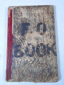
Administrative record - Factory Order Book
Initially listed as T J Connelly's Tin shop, this premises on the corner of High and Forest Street, expanded to include all items of ironmongery. By 1878 they were advertising gas stoves for sale and installation.The item is a hard cover book recording factory orders of T.J. Connolly, Ironmongers, Sandhurst. The book has an alphabetical index at the front which records customer names and number/s of their order. Each handwritten page records the order number, date, name and goods supplied. The hard cardboard cover has "F O BOOK" added to it with black ink. The front cover has considerable wearing to the bottom middle including water damage. The mottled front and back covers have considerable wear. The red spine covering is worn, and the cover is starting to come away from the pages at the top. The book includes the date range of October 1890 to August 1894. All pages have been used. This item is part of the Margaret Roberts Collection. The hard cardboard cover has "F O BOOK" added to it with black ink.margaret roberts collection, ironmongers, forest street, bendigo businesses -
 Bendigo Historical Society Inc.
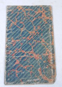
Administrative record - Customer List
Initially listed as T J Connelly's Tin shop, this premises on the corner of High and Forest Street, expanded to include all items of ironmongery. By 1878 they were advertising gas stoves for sale and installation.The item is alphabetical customer list of T.J. Connolly, Ironmongers, Sandhurst. Each handwritten page lists the customer name and order number. Note: corresponding orders are not in this book. The book does not have a date reference in it. The book has a flexible cardboard cover and the pages are bound together with string. This item is part of the Margaret Roberts Collection.There is a black mark at the bottom right-hand side of the front cover. There are some grey lead notes on the inside front cover. There are two mirrored ink marks on the back inside cover and last page.margaret roberts collection, ironmongers, forest street, bendigo businesses -
 Bendigo Historical Society Inc.
Booklet - Comic play
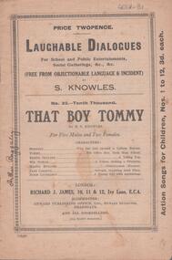
Booklet owned by Arthur Baggaley, Fruiterer, who lived at 15 Forest Street, Bendigo. His business 'C.A. Baggaley & Son' was at Covent Garden, Mitchell Street, Bendigo. Arthur was born in Bendigo in 1903 to Charles Arthur Baggaley and Ada (Mallon). He married Evelyn May Grigg. Arthur died in September, 1993.Six page booklet. On front cover 'Laughable Dialogues for school and public entertainments, social gatherings, &c, &c, (free from objectionable language and incident) by S. Knowles, No. 32 - Tenth Thousand, That Boy Tommy'. Baggaley CollectionWritten in black pen down left hand side of front page 'Arthur Baggaley'fruiterer, confectioner, business, mitchell street, covent garden, entertainment, play script -
 Whitehorse Historical Society Inc.
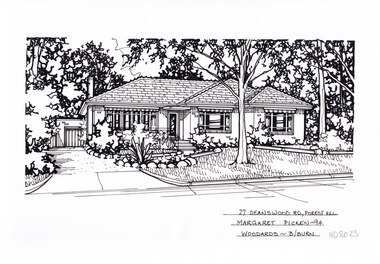
Artwork, other - Ink Line Drawing, Margaret Picken, 27 Deanswood Rd., Forest Hill, 1994
A property illustration by Margaret Picken Commissioned by the real estate agency Woodards Blackburn for the purpose of advertising 27 Deanswood Rd., Forest Hill This property is listed as having sold for $161,000 in 1994 Made by using Rotring ‘Rapidigraph’ drafting pens with Rotring ink on Rapidigraph polyester drafting film, double matte. Trained as a cartographic draftsman within the mining industry, Margaret Picken is an artist who worked producing property illustrations for real estate agencies in eastern suburbs of Victoria from 1983-2005. Retiring from the industry as technological changes favored coloured photography over illustrations, and commissioning companies over sole contractors.This artwork is of Historical Significance as a record of local domestic architecture.A black ink line drawing on drafters film by Margaret Picken, of 27 Deanswood Rd., Forest Hill. Of a one story house with a porch, steps and path leading up from the driveway on the left which leads to a detached garage in the background. A front yard with lawn, and rock edge garden beds. There are two hole punch holes along the top edge27 Deanswood Rd., Forest Hill Margaret Picken -94 Woodards B/Burnwhitehorse historical society, schwerkolt cottage, housing, architecture, margaret picken, house, garden, forest hill -
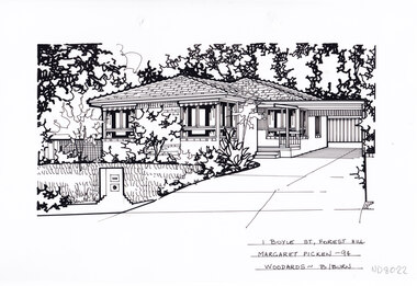 Whitehorse Historical Society Inc.
Artwork, other - Ink Line Drawing, Margaret Picken, 1 Boyle St., Forest Hill, 1994
A property illustration by Margaret Picken Commissioned by the real estate agency Woodards Blackburn for the purpose of advertising 1 Boyle St., Forest Hill This property is listed as having sold for $144,500 in 1994 Made by using Rotring ‘Rapidigraph’ drafting pens with Rotring ink on Rapidigraph polyester drafting film, double matte. Trained as a cartographic draftsman within the mining industry, Margaret Picken is an artist who worked producing property illustrations for real estate agencies in eastern suburbs of Victoria from 1983-2005. Retiring from the industry as technological changes favored coloured photography over illustrations, and commissioning companies over sole contractors.This artwork is of Historical Significance as a record of local domestic architecture.A black ink line drawing on drafters film by Margaret Picken, of 1 Boyle St., Forest Hill of a two story house with a double garage in the background. Of a driveway on the left leading to a carport, with a path leading to the entrance of a one story brick house. There are two hole punch holes along the top edge, with the punched out holes still attached.1 Boyle St., Forest Hill Margaret Picken -94 Woodards B/Burnwhitehorse historical society, schwerkolt cottage, housing, architecture, margaret picken, house, garden, forest hill -
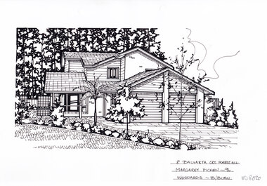 Whitehorse Historical Society Inc.
Artwork, other - Ink Line Drawing, Margaret Picken, 8 Balyarta Crt., Forest Hill, 1996
A property illustration by Margaret Picken Commissioned by the real estate agency Woodards Blackburn for the purpose of advertising 8 Balyarta Crt., Forest Hill This property is listed as having sold for $158,000 in 1996 Made by using Rotring ‘Rapidigraph’ drafting pens with Rotring ink on Rapidigraph polyester drafting film, double matte. Trained as a cartographic draftsman within the mining industry, Margaret Picken is an artist who worked producing property illustrations for real estate agencies in eastern suburbs of Victoria from 1983-2005. Retiring from the industry as technological changes favored coloured photography over illustrations, and commissioning companies over sole contractors.This artwork is of Historical Significance as a record of local domestic architecture.A black ink line drawing on drafters film by Margaret Picken, of 8 Balyarta Crt., Forest Hill Of a two story house with a double garage in the background. A landscaped front lawn in the left foreground, and a driveway leading to the the garage in the right foreground. There are 2 hole punch holes along the top edge.8 Balyarta Crt., Forest Hill Margaret Picken -96 Woodards B/Burnwhitehorse historical society, schwerkolt cottage, housing, architecture, margaret picken, house, garden, forest hill -
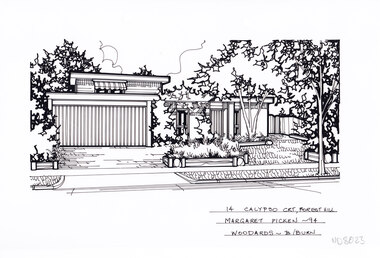 Whitehorse Historical Society Inc.
Artwork, other - Ink Line Drawing, Margaret Picken, 14 Calypso Crt., Forest Hill, 1994
A property illustration by Margaret Picken Commissioned by the real estate agency Woodards Blackburn for the purpose of advertising 14 Calypso Crt., Forest Hill This property is listed as having sold for $220,000 in 1994. Made by using Rotring ‘Rapidigraph’ drafting pens with Rotring ink on Rapidigraph polyester drafting film, double matte. Trained as a cartographic draftsman within the mining industry, Margaret Picken is an artist who worked producing property illustrations for real estate agencies in eastern suburbs of Victoria from 1983-2005. Retiring from the industry as technological changes favored coloured photography over illustrations, and commissioning companies over sole contractors.This artwork is of Historical Significance as a record of local domestic architecture.A black ink line drawing on drafters film by Margaret Picken, of 14 Calypso Crt., Forest Hill of a two story house with a double garage in the background. A flat roofed two story house with garage. On the left is the driveway, and on the right a front lawn with garden beds and trees. There are two hole punch holes along the top edge.14 Calypso Crt., Forest Hill Margaret Picken -94 Woodards - B/Burnwhitehorse historical society, schwerkolt cottage, housing, architecture, margaret picken, house, garden, forest hill -
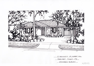 Whitehorse Historical Society Inc.
Artwork, other - Ink Line Drawing, Margaret Picken, 2 Bennett St., Forest Hill, 1994
A property illustration by Margaret Picken Commissioned by the real estate agency Woodards Blackburn for the purpose of advertising 2 Bennett St., Forest Hill This property built circa 1960's, is listed as having sold for $144,500 in 1994 Made by using Rotring ‘Rapidigraph’ drafting pens with Rotring ink on Rapidigraph polyester drafting film, double matte. Trained as a cartographic draftsman within the mining industry, Margaret Picken is an artist who worked producing property illustrations for real estate agencies in eastern suburbs of Victoria from 1983-2005. Retiring from the industry as technological changes favored coloured photography over illustrations, and commissioning companies over sole contractors.This artwork is of Historical Significance as a record of local domestic architecture.A black ink line drawing on drafters film by Margaret Picken, of 2 Bennett St., Forest Hill Of a two story house with a double garage in the background. Of a driveway on the left leading to a carport, with a path leading to the entrance of a one story brick house. There are two hole punch holes along the top edge.2 Bennett St., Forest Hill Margaret Picken -94 Woodards B/Burnwhitehorse historical society, schwerkolt cottage, housing, architecture, margaret picken, house, garden, forest hill -
 Whitehorse Historical Society Inc.
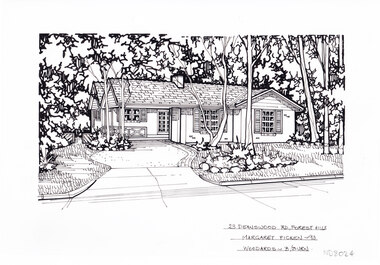
Artwork, other - Ink Line Drawing, Margaret Picken, 23 Deanswood Rd., Forest Hill, 1993
A property illustration by Margaret Picken Commissioned by the real estate agency Woodards Blackburn for the purpose of advertising 23 Deanswood Rd., Forest Hill This property is listed as having sold for $215,000 in 1993 Made by using Rotring ‘Rapidigraph’ drafting pens with Rotring ink on Rapidigraph polyester drafting film, double matte. Trained as a cartographic draftsman within the mining industry, Margaret Picken is an artist who worked producing property illustrations for real estate agencies in eastern suburbs of Victoria from 1983-2005. Retiring from the industry as technological changes favored coloured photography over illustrations, and commissioning companies over sole contractors.This artwork is of Historical Significance as a record of local domestic architecture.A black ink line drawing on drafters film by Margaret Picken, of 23 Deanswood Rd., Forest Hill. In the background a single story brick house with porch surrounded by trees, a driveway on the left leading to the house. In the foreground on the right is a front lawn with five trees. There are two hole punch holes along the top edge.23 Deanswood Rd., Forest Hill Margaret Picken -93 Woodards B/Burnwhitehorse historical society, schwerkolt cottage, housing, architecture, margaret picken, house, garden, forest hill -
 Whitehorse Historical Society Inc.
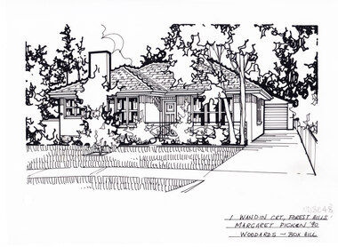
Artwork, other - Ink Line Drawing, Margaret Picken, 1 Wandin Crt., Forest Hill, 1990
A property illustration by Margaret Picken Commissioned by the real estate agency Woodards Boxhill for the purpose of advertising 1 Wandin Crt., Forest Hill built circa 1950. This property has be listed as having sold for $119,950 in 1991. Made by using Rotring ‘Rapidigraph’ drafting pens with Rotring ink on Rapidigraph polyester drafting film, double matte. Trained as a cartographic draftsman within the mining industry, Margaret Picken is an artist who worked producing property illustrations for real estate agencies in eastern suburbs of Victoria from 1983-2005. Retiring from the industry as technological changes favored coloured photography over illustrations, and commissioning companies over sole contractors.This artwork is of Historical Significance as a record of local domestic architecture.A black ink line drawing on drafters film by Margaret Picken, of 1 Wandin Crt., Forest Hill depicting a brick single story house with chimney set back from a front lawn with shrubs and trees. On the Right is a driveway leading to a separate garage. There are two hole punch holes near the centre of the left edge1 Wandin Crt., Forest Hill Margaret Picken '90 Woodards - BoxHillwhitehorse historical society, schwerkolt cottage, housing, architecture, margaret picken, house, garden, forest hill, real estate -
 Whitehorse Historical Society Inc.
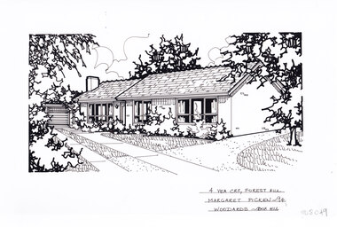
Artwork, other - Ink Line Drawing, Margaret Picken, 4 Yea Crt., Forest Hill, 1994
A property illustration by Margaret Picken Commissioned by the real estate agency Woodards Boxhill for the purpose of advertising 4 Yea Crt., Forest Hill. This property has be listed as having sold for $120,000 in 1994. Made by using Rotring ‘Rapidigraph’ drafting pens with Rotring ink on Rapidigraph polyester drafting film, double matte. Trained as a cartographic draftsman within the mining industry, Margaret Picken is an artist who worked producing property illustrations for real estate agencies in eastern suburbs of Victoria from 1983-2005. Retiring from the industry as technological changes favored coloured photography over illustrations, and commissioning companies over sole contractors.This artwork is of Historical Significance as a record of local domestic architecture.A black ink line drawing on drafters film by Margaret Picken, of 4 Yea Crt., Forest Hill depicting a brick single story house, with a driveway on the left leading to separate garage. off of the driveway are two paths, one past the front of the house and one up to the front door. There are two hole punch holes near the centre of the upper edge4 Yea Crt., Forest Hill Margaret Picken '94 Woodards - BoxHillwhitehorse historical society, schwerkolt cottage, housing, architecture, margaret picken, house, garden, forest hill, real estate -
 Whitehorse Historical Society Inc.
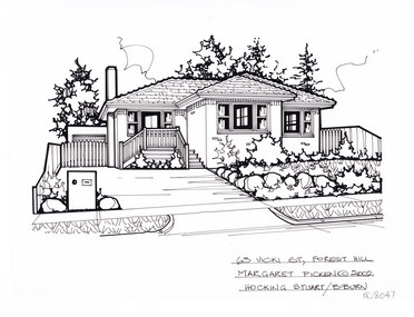
Artwork, other - Ink Line Drawing, Margaret Picken, 63 Vicki St., Forest Hill, 1998
A property illustration by Margaret Picken Commissioned by the real estate agency Hocking Stuart Blackburn for the purpose of advertising 63 Vicki St., Forest Hill This property has be subdivided into two house since being sold in 2002. Made by using Rotring ‘Rapidigraph’ drafting pens with Rotring ink on Rapidigraph polyester drafting film, double matte. Trained as a cartographic draftsman within the mining industry, Margaret Picken is an artist who worked producing property illustrations for real estate agencies in eastern suburbs of Victoria from 1983-2005. Retiring from the industry as technological changes favored coloured photography over illustrations, and commissioning companies over sole contractors.This artwork is of Historical Significance as a record of local domestic architecture.A black ink line drawing on drafters film by Margaret Picken, of 63 Vicki St., Forest Hill depicting a single story brick house with steps up the concealed doorway. On the left a driveway leads to a gated garage, on the right in the foreground is a front garden.63 Vicki St., Forest Hill Margaret Picken © 2002 Hocking Stuart B/Burnwhitehorse historical society, schwerkolt cottage, housing, architecture, margaret picken, house, garden, forest hill, real estate