Showing 608 items
matching boundary road
-
 Port Melbourne Historical & Preservation Society
Plan - Metalling and channelling Evans Street from Ingles Street to Boundary Street, 14 Mar 1893
Specifications (94.1) and Plan (94.2) for metalling and channelling Evans Street from Ingles Street to Boundary Street . Loan Works 1893. Plan number 8.Both signed by J.J. Bartlett. (Mayor).engineering - roads streets lanes and footpaths, town planning, town clerks, mayors, arthur victor heath, james john bartlett -
Port Melbourne Historical & Preservation Society
Document - Specification, Metalling and chanelling, Danks Street from Esplanade East to Boundary Street South, Engineering Department, Town of Port Melbourne, 14 Mar 1893
Specification for metalling and channelling Danks Street from Esplanade East to Boundary Street South (Pickles Street) Loan Works 1893 plan 19; relates to plan 98.2Signed by JJ Bartlett (Mayor) 14.3.1893engineering - roads streets lanes and footpaths, town planning, town clerks, mayors, arthur victor heath, james john bartlett -
Port Melbourne Historical & Preservation Society
Plan - Metalling and channelling Danks Street from Esplanade East to Boundary Street South, Engineering Department, Town of Port Melbourne, 14 Mar 1893
Plan for metalling and channelling Danks Street from Esplanade East to Boundary Street South (Pickles Street) Loan Works 1893 plan 19; relates to specification 98.1Signed by JJ Bartlett (Mayor) 14.3.1893engineering - roads streets lanes and footpaths, town planning, town clerks, mayors, arthur victor heath, james john bartlett -
Port Melbourne Historical & Preservation Society
Plan - Evans Street from ingles Street to Boundary Street, 1893 - 1919
Plan of Evans Street from Ingles Street to Boundary Street 1893..engineering - roads streets lanes and footpaths -
Port Melbourne Historical & Preservation Society
Plan - Boundary Street from Quinn Street to Evans Street, Engineering Department, Town of Port Melbourne, 1893 - 1919
Plan of Boundary Street from Quinn Street to Evans Street 1893.engineering - roads streets lanes and footpaths -
Port Melbourne Historical & Preservation Society
Plan - Evans Street from Ingles Street to Boundary Street, Engineering Department, Town of Port Melbourne, 1893 - 1919
Plan of Evans Street from Ingles Street to Boundary Street Loan no 5 1893.engineering - roads streets lanes and footpaths -
 Port Melbourne Historical & Preservation Society
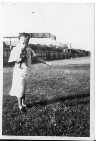
Photograph - Fred Nicholson and his mother, bridge over railway at Boundary Street, Port Melbourne, 1938
Photo showing bridge over railway at Boundary St. Fred Nicholson and his mother, 1938.families, engineering - roads streets lanes and footpaths, fred nicholson, boundary street -
 Coal Creek Community Park & Museum
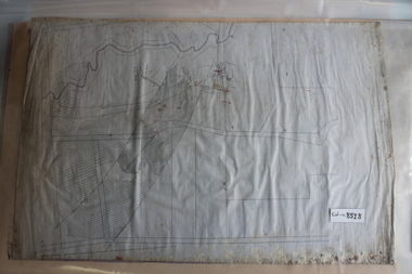
Mine Map
... , tramways, boreholes, surface roads and (apparently) paddock...Coal Creek Community Park & Museum 12 Silkstone Road ...6306.1 - Map of Outtrim mining area, with modification where damage/erasure has occurred. Shows tunnels, faults, tramways, boreholes, surface roads and (apparently) paddock boundaries and a creek. -
 Coal Creek Community Park & Museum
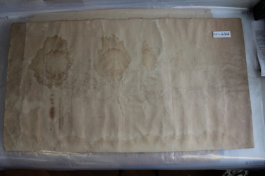
Mine Map
... , boreholes, creeks, roads and (presumably) paddock boundaries. Based...Coal Creek Community Park & Museum 12 Silkstone Road ...8518.1 - Unlabelled map of mining tunnels, coal seams, boreholes, creeks, roads and (presumably) paddock boundaries. Based on features in common with other maps, very likely map of Korumburra area. -
 Port Melbourne Historical & Preservation Society
Photograph - J Kitchen & Sons perimeter survey, Boundary Street, Dec 2013
As the former j Kitchen & Sons site was being cleared, Lionel Layfield, who had worked at the site for many years undertook several pictorial perimeter surveys. These photos were taken in Dec 2013.Series 1 of colour photographs taken by Lionel Layfield as he walked around the perimeter of the J Kitchen & Sons Pty Ltd factory site during the early demolition of most of the buildings. .37-.45 - along Boundary Street past White Street to Normanby Roadindustry - manufacturing, built environment - industrial, business and traders - soaps/candles, j kitchen & sons pty ltd, symex holdings ltd, north port oval, port melbourne cricket and football oval -
 Monbulk RSL Sub Branch
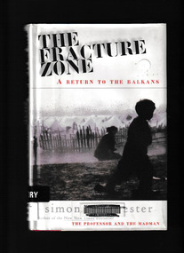
Book, Harper Collins, The fracture zone : a return to the Balkans, 1999
Winchester travels in a scimitar-shaped journey through Croatia, Bosnia, Montenegreo, Macedonia, Bulgaria and Greece to Turkey. He names his route the Fracture Zone, because this locale marks not only the meeting of two vast continental tectonic plates, perpetrators of geological chaos, but also the uneasy boundary between two great historical empires, the Hapsburg and the Ottoman." "The Fracture Zone weaves together history, travel and political perspective with the personal testaments of ordinary and extraordinary people. In this record of history, hatred and ruin, Simon Winchester details the conditions under which the area's refuges now live against a background of ancient political and spiritual struggleGlossary, maps, p.236.non-fictionWinchester travels in a scimitar-shaped journey through Croatia, Bosnia, Montenegreo, Macedonia, Bulgaria and Greece to Turkey. He names his route the Fracture Zone, because this locale marks not only the meeting of two vast continental tectonic plates, perpetrators of geological chaos, but also the uneasy boundary between two great historical empires, the Hapsburg and the Ottoman." "The Fracture Zone weaves together history, travel and political perspective with the personal testaments of ordinary and extraordinary people. In this record of history, hatred and ruin, Simon Winchester details the conditions under which the area's refuges now live against a background of ancient political and spiritual strugglebalkan peninsula - history, balkan peninsula - travel -
Tatura Irrigation & Wartime Camps Museum
Print - Heaphy's Whim - Inn Framed Print, Heaphy's Whim Inn
The inn was located on the SW corner of the intersection now known as Dhurringile Rd and Hogan St. There is now no trace of the pictured building. This was the northern boundary of the James Winter estate and was called " Nelson Gate ". The town "whim " ( water pump ) was near the Brown St / Albert St round-a -boutBlack and white print in a black plastic frame with white card surround. Inn with horses and carts, people in the carts, people standing under verandah and off to the side. Wide section of road in front and trees behind -
 Hume City Civic Collection
Photograph, early 1990s
The series of 5 photographs feature different views of the Woodlands housing development which opened up land bounded by Gap and Anderson Roads, Cornish Street and Elizabeth Drive in the early 1990s. It was a large housing development built close to Sunbury township.A view of the northern boundary of the Woodlands housing development in Anderson Road. A paling fence divides the estate from the 'Malley' factory, now 'Storage King' which is on the corner of Cornish Street and Anderson Road. A 'For Sale' sign is in the foreground and a partly built house is in the middle distance.housing developments, anderson road, george evans collection -
 Sunshine and District Historical Society Incorporated
Map (1967), CITY OF SUNSHINE, June 1967, 1967
The City of Sunshine no longer exists. Part of the eastern area has been annexed by the City of Maribyrnong, and the rest of the old City of Sunshine has been amalgamated with the City of Keilor to form the larger City of Brimbank.This 1967 map is a historical record of the City of Sunshine as it existed 27 years before the amalgamation of Councils, and the creation of the City of Brimbank in 1994.Whitish paper map with black printing that is laminated in clear plastic film, and has a wood slat attached to the top edge. The June 1967 map is of the previous CITY OF SUNSHINE showing City and Parish boundaries, streets, railways, creeks, river etc.Purple ink stamps at top left hand and right hand areas showing address and contact details of 'Sunshine Industrial Promotion Centre.'city of sunshine, june 1967, map, city, parish, boundaries, brimbank -
Clunes Museum
Map, 1962
.1 &.2 MAP OF BALLARAT SHIRE GROUP RURAL FIRE BRIGADES FIRE CONTROL MAP. COMPILED BY C. H. FENTON. (2 COPIES) DETAILING SEALED ROADS, STATE FORESTS, PINE PLANTATIONS, FOREST AREAS, RAILWAYS, BOUNDARIES, TOWNSHIP AREAS CEMETERIES, CREEKS, SWAMPS AND HOUSES.local history, document, maps, fire brigade -
 Peterborough History Group
Document - Maps, tourist information
... Peterborough History Group Peterborough great-ocean-road ...Council boundaries, past tourist information, past mapsHistoric town information and mapsPhotocopies, copies of maps, newspaper clippingpeterborough history, peterborough 3270 -
 Peterborough History Group
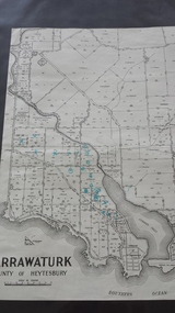
Map - Map of Curdies River Inlet district, Narrawaturk
... Peterborough History Group Peterborough great-ocean-road ...Shows the allotment boundaries and names of landowners at the timeSignificant as it shows owners of rural land in the Peterborough area.Photocopy of an old mapHandwritten notes and markings on the map.peterborough, curdies river, curdies river inlet, old maps, maps, narrawaturk -
 Peterborough History Group
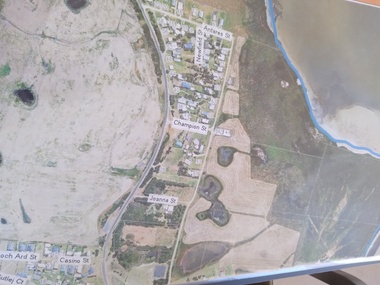
Plan - Moyne Shire Council Aerial photograph, Department of Sustainability and Environment, January 2018
View shows development at the time and showing the town boundary using Vicmap InformationSignificant in that it provides a record of the current state of development of the town. Also, a view of the estuary at that time.A3 size copy of an aerial view of the majority of the town with street names mentioned. curdies river inlet, peterborough, aerial view -
 Peterborough History Group
Map - Shire of Warrnambool
Map of the area, when Peterborough was part of Warrnambool ShireHistoric map of the area when Peterborough was in the Warrnambool ShireA3 size map, larger view of the whole shire of Warrnambool, and includes adjoining Shire Boundaries. Shows individual land allotments.peterborough, warrnambool shire, old maps -
Peterborough History Group
Newspaper articles pertaining to Peterborough from 1990 to 1999
Various newspaper articles kept by Mrs Dawn Irvine, all pertaining to Peterborough - river flooding and quality, concerns over council boundary realignment. Article titles: 6/10/1992 Flooding at Peterborough 28/6/1994 Residents undecided over River 4/7/1994 Letter from Warren Moore. Peterborough is alive, the way residents like it. 26/12/1994 Letter from R. Irvine. Apprehension over changes 17/6/1998 Algae fear prompts call to open Curdies River 13/4/1999 Battlelines on the Curdies 14/4/1999 Peterborough residents urge BHP to find alternative waste disposal optionHistoric overview of the towns' concerns at that time. Seven newspaper cuttings of various sizes all regarding aspects of Peterborough. Includes objection to BHP discharging waste into the Curdies River and flooding. warren moore, ronald irvine, curdies river, moyne council, council boundary realignment, curdies river flooding, floods, peterborough, blue green algae, river quality, bhp waste management, bhp -
 Whitehorse Historical Society Inc.
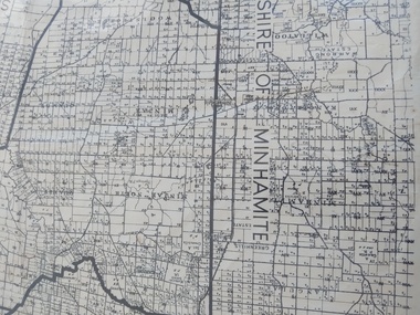
Legal record - Map, Parish of Nunawading, c1930
Office of Lands and survey map, 1864 with many further subdivisions of 1870 onwards added.Office of Lands and survey map, 1864 with many further subdivisions of 1870 onwards added. Boundaries of City of Box Hill included. Note added re Slater's land in Blackburn North. Office of Lands and survey map, 1864 with many further subdivisions of 1870 onwards added. maps, shire of blackburn and mitcham, city of box hill, slater family -
Whitehorse Historical Society Inc.
Article, Joint swimming pool proposed, 1967
Nunawading Council is to ask Doncaster and Templestowe Council to consider the construction of a swimming pool near the boundary of the two cities.Nunawading Council is to ask Doncaster and Templestowe Council to consider the construction of a swimming pool near the boundary of the two cities. The proposal came from Cr Keith Rooney.Nunawading Council is to ask Doncaster and Templestowe Council to consider the construction of a swimming pool near the boundary of the two cities. city of nunawading, city of doncaster and templestowe., swimming pools. -
Whitehorse Historical Society Inc.
Article, Thousands switch seats; Deakin spills east, 1968
Photocopy of article about an electoral redistribution which transfers part of Box Hill from Bruce to Deakin.Photocopy of article about an electoral redistribution which transfers part of Box Hill from Bruce to Deakin. The changes also affect Blackburn, East Burwood, Forest Hill, Vermont and Heatherdale.Photocopy of article about an electoral redistribution which transfers part of Box Hill from Bruce to Deakin. electoral boundaries, box hill, blackburn, burwood east, forest hill, vermont, heatherdale, jarman, alan -
Whitehorse Historical Society Inc.
Document, Shire of Blackburn and Mitcham, 1926
By-laws nominating boundaries of ridings and 'Populous areas'.By-laws nominating boundaries of ridings and 'Populous areas'.By-laws nominating boundaries of ridings and 'Populous areas'.local government, shire of blackburn and mitcham -
Whitehorse Historical Society Inc.
Map, Aerial Photographs Nunawading, 1970
State Aerial Survey, Melbourne 1970.State Aerial Survey, Melbourne 1970. Project runs 34 - 39 - City of Nunawading. Frames numbered from South to North boundaries, each strip numbered from East to West. See table of index and photo numbers attached.non-fictionState Aerial Survey, Melbourne 1970.state aerial survey, aerial photographs, nunawading, mitcham, blackburn, blackburn north, blackburn south, forest hill, vermont, burwood east, vermont south -
Whitehorse Historical Society Inc.
Map, Aerial photographs Nunawading, 1972
Department of Crown Lands and Survey, Melbourne, 1972.Department of Crown Lands and Survey, Melbourne, 1972. Project runs 34 - 39 - City of Nunawading. frames numbered from South to North boundaries, each strip numbered from West to east. The series extends further West to Box Hill and East to Ringwood than the 1970 project. No index map. Sheets 39/2 and 34/28 missing.non-fictionDepartment of Crown Lands and Survey, Melbourne, 1972.victoria. department of crown lands and survey, aerial photographs, nunawading, mitcham, blackburn, blackburn north, blackburn south, forest hill, vermont, burwood east, box hill, ringwood, vermont south -
Whitehorse Historical Society Inc.
Map, Aerial photographs Nunawading, 1976
Department of Crown Lands and Survey, Melbourne, 1976 Project.Department of Crown Lands and Survey, Melbourne, 1976 Project. Runs 29 - 33 City of Nunawading. Frames numbered from South to North boundaries, each strip numbered from West to East. No index map. Sheets 30/8 and 30/9 missing.non-fictionDepartment of Crown Lands and Survey, Melbourne, 1976 Project. victoria. department of crown lands and survey, aerial photographs, nunawading, mitcham, blackburn, blackburn north, blackburn south, forest hill, vermont, vermont south, burwood east, box hill, ringwood -
Whitehorse Historical Society Inc.
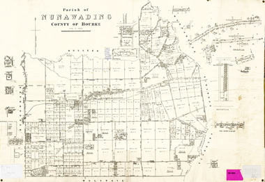
Map, Nunawading Shire, 1892
... Covers Middleborough Road to Ringwood boundary. One map... boundary. One map (Blackburn) from north of Whitehorse Road... Mitcham melbourne Covers Middleborough Road to Ringwood boundary ...Photocopy of an enlargement of map of Shire of Nunawading showing landowners in 1892.Photocopy of an enlargement of map of Shire of Nunawading showing landowners in 1892. Covers Middleborough Road to Ringwood boundary. One map (Blackburn) from north of Whitehorse Road to Highbury Road, 2nd map (Mitcham) Bulleen to south of Canterbury Road; 3rd map Whitehorse Road to Highbury Road.Photocopy of an enlargement of map of Shire of Nunawading showing landowners in 1892. maps, shire of nunawading, blackburn, blackburn south, nunawading, forest hill, vermont, mitcham, vermont south -
Whitehorse Historical Society Inc.
Article, Nunawading happy to talk on boundary changes, 1985
Mayor of Nunawading, Bill Coyne, says Nunawading would be happy to confer with neighbouring councils about the local government re-structuring issue.Mayor of Nunawading, Bill Coyne, says Nunawading would be happy to confer with neighbouring councils about the local government re-structuring issue.Mayor of Nunawading, Bill Coyne, says Nunawading would be happy to confer with neighbouring councils about the local government re-structuring issue.local government, city of nunawading, coyne, bill, amalgamations -
Whitehorse Historical Society Inc.
Article, Box Hill keen to retain its existing boundaries, 1986
Article about discussions over Box Hill and Nunawading boundaries.Article about discussions over Box Hill and Nunawading boundaries.Article about discussions over Box Hill and Nunawading boundaries.local government, city of box hill, city of nunawading, amalgamations