Showing 8323 items
matching bridging
-
 Lakes Entrance Historical Society
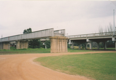
Photograph - Old Railway bridge over Mitchell River, Bairnsdale Victoria, 1/05/2005 12:00:00 AM
The bridge was built 1912 / 13 c on concrete piers, single track with steel guard fence with concrete road bridge adjacen.tColour photograph of the remnant of railway bridge across the Mitchell River at Bairnsdale Victoria. Second photo from a different angle.railway, bridges, engineering -
 Halls Gap & Grampians Historical Society
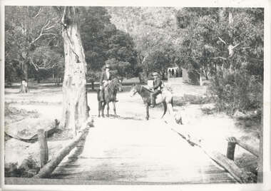
Photograph - B/W, C 1920s
The Stoney Creek dray bridge. Stoney Creek has been bridged a number of times on school road since the creek was re-routed in the early 1900s. A dray bridge was built C 1910 by local residents, which stood them in good stead for more than a decade. This bridge was replaced by a higher timber structure. Image two is a story from 1906 relating to Marshall White and his family trying to recross Delley's bridge after finding the Stoney Creek dray bridge washed away.Photo of two men on horseback on a wooden bridge with low log railing. A shelter can be seen in the background and there are thick trees surrounding the road.structures, bridges -
 Bendigo Military Museum
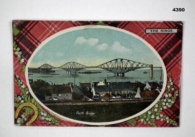
Postcard - SOUVENIR POSTCARD, c. WW2
The photo featuring the Forth Bridge was collected by F.G.Davey during WW2. Part of the Frederick Gardner Davey DFC RAAF collection. Refer Cat No 3536P for his service details.Postcard, rectangular featuring a colour photograph of a bridge in oval shape with a white edge with a tartan background, back ground features sprays of white flowers and a horseshoe, the name of the bridge is printed on the photo in white text, on the back printed in brown type are details of the bridges constructionand space for correspondence and a stamp.postcard, souvenir, ww2, bridges -
 Phillip Island and District Historical Society Inc.
Photograph, 1978/9
In 1940 Churchill Island was bought by Dr Edward Henry Jenkins - a Melbourne Dentist, who built the bridge to Phillip Island.Coloured photograph showing the bridge from Churchill Island to Phillip Islandlocal history, photographs, buildings - historical, rural industry, bridges, coloured photograph, john cook, churchill island -
 Kew Historical Society Inc
Photograph, Outer Circle Railway Bridge over River Yarra, c.1900
This photograph forms part of the Eric Sibly collection of images and information relating to the Outer Circle Railway which he donated to the Kew Historical Society in 1974. Heritage Victoria Citation (Abridged) "The Chandler Highway Bridge, a 137 metre wrought iron lattice-truss girder bridge with four spans supported on red brick piers with moulded bluestone cappings. The bridge has a cantilevered walkway along the west side. ...The Chandler Highway Bridge crosses the Yarra River and connects Alphington and Kew. It was completed in November 1890 as part of the Outer Circle Railway Line.Black & white photograph of the railway viaduct over Yarra River looking south towards Kew.Reverse: "Pre 1930. Outer Circle Railway Bridge over River Yarra (now Chandler Highway) - note bridge over line on Kew side for Asylum Farm". KH - 56. Kew Historical Society.chandler highway, railway bridges - kew (vic), sir john monash, outer circle railway, river yarra - kew (vic) -
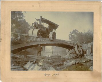 Bendigo Historical Society Inc.
Photograph - Monier Bridge Collapse, May, 1902
In 1867 Frenchman, Joseph Monier patented reinforced concrete horticultural troughs. In 1873 this process was extended to iron reinforced bridges with the first bridge built in 1875. In Australia, Sir John Monash of Monash and Anderson company, originally built 8 Monier bridges in Bendigo all single arch except Weeroona Ave., which was a double arch. Six of these remain.Black and white photograph. Steam rollers appears to have collapsed from a Monier bridge with men investigating amidst the rubble with one steam roller remaining on the bridge, and another resting in a creek underneath. Photograph by W. H. Robinson. Photograph mounted on cream-coloured card.Written on the front in black ink 'May 1902.'monier bridges, bendigo creek, accidents -
 Chelsea & District Historical Society Inc
Photograph - Patterson River, Rail and Road Bridge, c 1910
The first bridge over the river was built in the early 1880's, prior to this it was a pontoon bridge.Black and white photo of the wooden road bridge (Point Nepean / Nepean Highway), over Patterson River, Carrum near the mouth of the river. patterson river, road bridge, rail bridge, chelsea, transport, patterson river bridge, carrum bridge -
 Phillip Island and District Historical Society Inc.
Postcard, 1940's
This Postcard, from the Estate of Keith McIlwraith 20th July 1983, shows the first Phillip Island Bridge which lasted from 1940 till 1969.The first Phillip Island bridge, opened on 29th November 1940.local history, documents, postcards, civil engineering, bridges, early postcard, postcard, phillip island bridges -
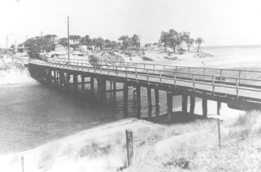
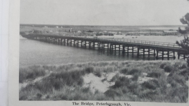 Peterborough History Group
Postcard - Peterborough Hotel and Peterborough Bridge Postcard
Historic picture of the Peterborough Hotel and the bridgeHistoric significancePost card from a fold out Postcard. Double sided picture of The Peterborough Hotel and the Peterborough Bridgepeterborough hotel, curdies river -bridge, peterborough, irvine family, peterborough bridge, historic hotel, postcards, vintage postcards -
Phillip Island and District Historical Society Inc.
Ribbon, November, 1969
Part of a collection presented and donated by Mrs Helen Jansson. Second Phillip Island Bridge Opening 21/11/1969 by Hon M. V. Porter, MLA, Minister of Public Works.Green Satin Ribbon with gold letteringPhillip Island Bridge Opening 21st November, 1969local history, civic mementos, souvenirs, phillip island bridge opening 1969, mrs helen jansson, second phillip island bridge 1969 -
 Kew Historical Society Inc
Photograph - Yarra Flats near Burke Road Bridge, 1937
Land along the Yarra River in Kew is now either designated open space, parkland or public golf links. By the 1930s much of this area remained open farmland, bought at auction for dairy farming in the 1840s.Original, black and white positive print of what is said to be the Yarra Flats near Burke Road Bridge. On the horizon, building can be seen, whereas in the middle ground, farm fencing and a windmill are the main features as well as remnant Eucalypts. Inscribed verso: "Yarra Flats near Burke Rd Bridge 1937" studley park -- kew (vic.) -
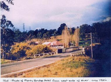 Greensborough Historical Society
Photograph - Digital image, Plenty Bridge Hotel from west side of river, 1950s
Colour photograph of Plenty Bridge Hotel (Lower Plenty) from west side of river. Also shows bluestone bridge over Plenty River at Lower Plenty.Digital copy of colour photograph.On front of photograph: "15d Plenty Bridge Hotel from west side of river circa 1950s"lower plenty, plenty bridge hotel -
 Phillip Island and District Historical Society Inc.
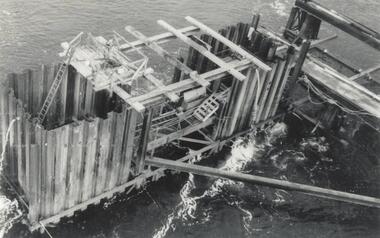
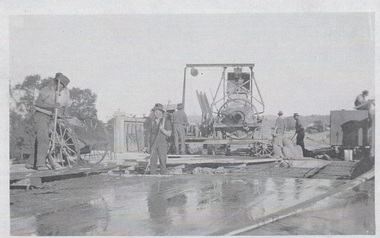
Photograph, Phillip Island Bridge, 1968/9
Construction of 2nd Phillip Island Bridge. 1969. From the Jack Jenner Collection.Scaffolding for concrete works for new Bridge. Top view of empty forming close-up.local history, photographs, civil engineering, bridges, phillip island bridges, black & white photograph, jack jenner collection, public construction -
 Charlton Golden Grains Museum Inc
Photograph, Cameron, Ian, 1973 February Flood, Feb 1973
1973 flood. High water depth under Paterson Bridge, Charlton Victoria,B/W photograph of 1973 flood. High water depth under Paterson Bridge.flood, james paterson bridge, charlton -
 Phillip Island and District Historical Society Inc.
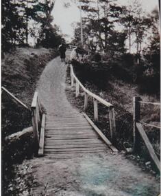
Photograph, Lovers Walk, Cowes, Phillip Island, ?
Lovers Walk extending from the east end of The Esplanade, Cowes, adjacent to the beach, towards Rose Street. Man walking away on track. A wooden railing extending from wooden bridge in foreground to diminishing track and back drop of trees.Lovers Walk track, wooden bridge in foregroundlocal history, photographs, lovers walk, cowes, black & white photograph, noel ayton collection, bruce bennett -
 Stawell Historical Society Inc
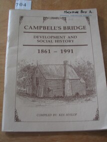
Book, Ken Hyslop, Campbells Bridge – Development and Social History 1861-1991, 1991
Compiled by Ken Hyslop for the Back to Campbells Bridge in November/ December 1991.Fawn Card Cover brown border enclosing title and sketch of house, and authors nameCampbell's Bridge Development and Social History 1861-1991. Compiled By Ken Hyslop.stawell -
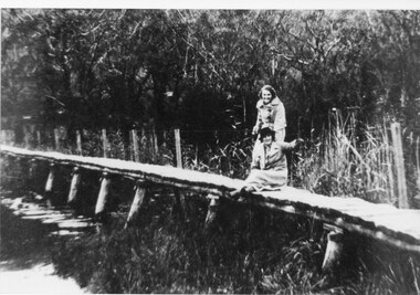 Halls Gap & Grampians Historical Society
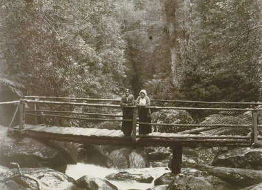
Photograph - B/W
Photo of foot-bridge over the Wannon crossing. c1920-Photo shows 2 women one seated, one standing on a wooden foot-bridge; both are wearing overcoats, one is wearing a hat. The bridge has post & wire fence on one side. Bush in background is thick so too reeds & rushes.structures, bridges -
Glenelg Shire Council Cultural Collection
Photograph - Photograph - men on deck of 'Hourai Maru', 1973
Port of Portland Authority AchievesBack: Party on bridge of the Hourai Maru - 8/3/73 - pencil + names of men in the photo * See other information for names.port of portland archives, hourai maru -
Clunes Museum
Tool - BROAD AXE
MR. TOM HARVEY USED THIS BROAD AXE BRIDGE BUILDINGAN AXE LIKE IMPLEMENT WITH LARGE SHAPED CUTTING EDGE WITH WOODEN HANDLE USED IN BRIDGE BUILDING.local history, tool, trade -
 Wodonga & District Historical Society Inc
Photograph - Construction of Wodonga Creek Bridge, 1920
The bridge over Wodonga Creek was opened on Friday 20th October 1922 by the Minister For Public Works Mr Frank. The erection of the bridge was carried out by Mr L Carr, of Brighton. The new concrete bridge was a little more than 500 feet long and consisted of 12 spans. The decking was supported by a number of steel girders, each weighing approximately seven tons. The whole bridge was supported by rows of three cylinders, sunk to a depth of 26ft below the summer water level. The original estimated cost of the structure was £20,000, but with the extras added during construction this amount was exceeded.These photos are significant because the capture the construction of an important bridge between Albury and Wodonga.Three black and white photographs taken during the construction of the new bridge over the Wodonga Creek in 1920.wodonga bridges, wodonga creek -
 Mission to Seafarers Victoria
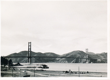
Photograph - Photograph, Black and white, Allan Charles Quinn, 9 November 1949
This photograph is part of series depicting Allan Quinn's travels through San Francisco in 1949. This photograph is a landscape shot of the Golden Gate Bridge.This is a photograph from the Allan Charles Quinn collection which is a collection of letters and photograph depicting aspects of life at sea for a young man in the era immediately following World War II.A black and white distance photograph of the Golden Gate Bridge, in San Francisco.Reverse: 9-11-49 handwritten in blue ink. K8 / B handwritten in pencil, upside.allan-quinn, photograph, san-francisco, golden-gate-bridge, 1949, merchant navy -
Hume City Civic Collection
Print, Rupertswood, 1983
The coloured print features the bridge which spans the Rupertswood Cutting and is north of Sunbury station on the Bendigo line with the Rupertswood Mansion in the middle distance.A large coloured print of a railway bridge spanning a river with a mansion in the distance.rupertswood mansion, rupertswood cutting, railways -
 Ballarat Heritage Services
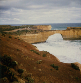
Photograph, London Bridge, Great Ocean Road, 01/1990
London Bridge, pre 1990 was a double-spanning bridge connected to the mainland. The stack was created over hundreds of years, with the weaker layers toward the base being eroded away by wind and water to form the two bridges. The span closer to the shoreline collapsed unexpectedly on 15 January 1990, leaving two visitors, whilst uninjured, stranded on the outer span before being rescued by helicopter. Two coloured photographs of the London Bridge, on the Great Ocean Road. This photo was taken days before the collapse of the geological feature. The photographer walked across the bridge to the warning of her mother "if you go over there and it collapses you will be stuck. After the collapse it was renamed London Arch. london bridge, great ocean road, london bridge, peterborough, london arch, shipwreck coast, 12 apostles -
 Marysville & District Historical Society
Photograph (item) - Black and white photograph, Unknown
A black and white photograph of two ladies standing on a timber bridge crossing the Taggerty River.A black and white photograph of two ladies standing on a timber bridge crossing the Taggerty River.taggerty river, timber bridge -
Marysville & District Historical Society
Flyer (item) - Information Flyer, Artworkz Tourism, Marysville-Historic Timber Tramway Trestle Bridge, Post 2009
A flyer that was produced as a guide to the historic timber tramway trestle bridge near Marysville in Victoria.A flyer that was produced as a guide to the historic timber tramway trestle bridge near Marysville in Victoria. The historic timber tramway trestle bridge is along the Michaeldene Walking Track near Marysville in Victoria. The Michaeldene Trail to Taggerty River Lookout is a 4.3 kilometer lightly trafficked loop trail located near Marysville, Victoria. The track is one of several walking tracks located in and around Marysville in Victoria.timber tramway trestle bridge, marysville, victoria, michaeldene walking track, taggerty river, taggerty river lookout -
 Marysville & District Historical Society
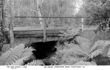
Postcard (Item) - Black and white postcard, Rose Stereograph Company, THE BRIDGE, NARBETHONG HOUSE, NARBETHONG, VIC, 1913-1967
A digital copy of a black and white postcard of a photograph taken of a bridge at Narbethong House in Narbethong.A digital copy of a black and white postcard of a photograph taken of a bridge at Narbethong House in Narbethong. This postcard was produced by The Rose Stereograph Company as a souvenir of Narbethong.narbethong, victoria, australia, postcard, rose series postcard, the rose stereograph company, narbethong house, wooden bridge, p. 2709 -
 Orbost & District Historical Society
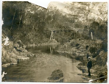
black and white photograph, first half 20th century
This appears to be the Boggy Creek bridge and to have been taken at Nowa Nowa. The Boggy Creek Bridge was built in 1916 as part of the Bairnsdale to Orbost extension to the main Gippsland Railway, and is situated in the middle of the township of Nowa Nowa, crossing a steep-sided and well-timbered creek-valley. This section of the line closed in 1987.This bridge plays a major part in the identity and history of the town of Nowa Nowa, since Boggy Creek’s steep sided valley divides the township into two components. It is part of the East Gippsland Railway line.A black / white photograph of a bridge across a creek. A young man in a suit is standing in the foreground.boggy-creek-bridge-nowa-nowa -
 Rutherglen Historical Society
Photograph - Image, Thalma, July 1911
Group photograph taken on the occasion of the opening of Lilliput Bridge in July 1911. Two individuals in the photograph have been identified as Olive Hiskins and her father John Hiskins.Group photograph, mounted on brown cardboard, Photographic studio identified at bottom of cardboard frame on front. Details of event written on back.On back "Opening Lilliput Bridge in 1911". "This photo given to W.H. Pleming on 7th July '75 by Mrs Tom Franki - nee Violet Withers (Ulina)" "The Bridge was replaced by a concrete Bridge in May 1940" On front "Thalma. Ilsley Opp. P.O. Rutherglen"olive hiskins, john hiskins, lillput bridge -
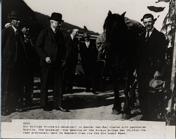 Lorne Historical Society
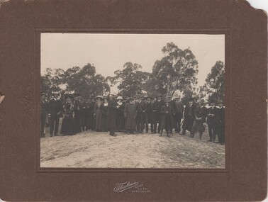
Photograph, Opening of Aireys Bridge 30 December 1932
Photograph of Sir William Irvine (Lt Govenor) at the opening of Airey's BridgePhoto of Sir William Irvine (Lt. Governor) at opening of Airey Bridge. 30th December 1932aireys bridge; sir william irvine, lt govenor, 30.12.1932 -
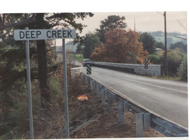 Sunbury Family History and Heritage Society Inc.
Photograph, Bulla, C 1980s
The photograph shows the approach to the Bulla Bridge at Deep Creek in the Township of Bulla. Immediately on crossing the bridge there is a sharp bend in the road and a step ascent up Bulla Hill through the cutting until level ground is reached. The photograph is looking to the NW. Deep Creek meets the Maribyrong River further downstream and closer to Keilor.The bridge and road replaced the ford crossing in 1869 that was downstream from the bridge.A coloured photograph of the approach to a bridge over the Deep Creek at Bulla along Sunbury Road. bulla bridge, deep creek, sunbury road