Showing 1581 items
matching clarke a
-
 Mt Dandenong & District Historical Society Inc.
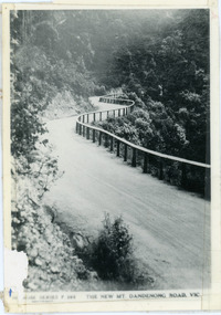
Photograph, The New Mt Dandenong Road, Vic
Copy of Rose Series postcard #385 showing the new Mt Dandenong Tourist Road with wooden railing fence on low side of road. Surface not yet made. This photograph has a detailed inscription on the back handwritten by John Lundy-Clarke in 1974.View downhill from the Windy Bend showing the site of the 1972 landslide. In this picture the road is running along the top edge of the wall 900’ thick of Kalorama Docite that plunges thousands of feet deep down into the earth below the Ranges and extends to Fern Tree Gully. It was once a horizontal terrace nearly ten miles square and tipped over to the left when the mountain subsided into its volcanic cauldron.mt dandenong road, rose series, windy bend, landslide -
 Mt Dandenong & District Historical Society Inc.
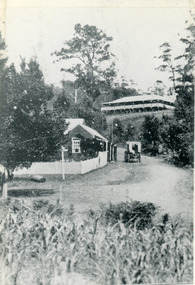
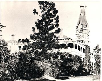
Photograph, The Gap at Kalorama 1913, 1913
1913 scene looking up to Mountjoy Guest House at the Kalorama Gap (FiveWays). Post Office and tea rooms with white picket fence. Jeeves Coach on the road. This photograph has a detailed inscription on the back handwritten by John Lundy-Clarke in 1974. The Gap Kalorama 1913. ‘Mountjoy’ guest house. Mount Dandenong North Post Office. Jeeves coach.fiveways, mountjoy, post office, mt dandenong north, the gap, jeeves, coach -
 Eltham District Historical Society Inc
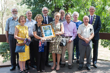
Photograph, Eltham District Historical Society, 2018 Community Group of the Year, 2018 Nillumbik Australia Day Awards, Eltham Community and Reception Centre, Main Road, Eltham, 26 January 2018
Members of the Eltham District Historical Society celebrate being awarded the Nillumbik 2018 Community Group of the Year award with Mayor Cr. Peter Clarke.Born Digital2018 community group of the year, ceremonies, cr. grant brooker, eltham community and reception centre, eltham district historical society, mayor cr. peter clarke, nillumbik shire council -
 Greensborough Historical Society
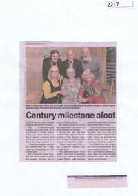
Newspaper clipping, Century milestone afoot, 24/06/2015
Mavis Clarke celebrated her 100th birthday with her family in June 2015. She recalls riding her horse to school in Lower Plenty.News clipping, black text, colour image.mavis clarke, lower plenty -
 Stawell Historical Society Inc
Photograph, Stawell Grammar School 1908
Donor Marion is Great Great niece of Angus Henry Clarke Shire Engineer of Stawell. His son Ronald possibly a student of the Grammar School.Two Black and white photographs of Stawell Grammar School 1902/3 & 1908Roseleigh House March 25th 1908. 1902/1903 on back of photo with child in garden 1908 on back of both photographs roseleigh, education -
 Bendigo Military Museum
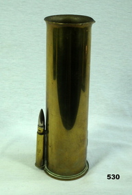
Memorabilia - TRENCH ART, BRASS VASE, Post 1941
Item belonged to Arthur C Clarke VX79039 2nd AIF. Refer 532 for main details. Item 531 goes with is one to make a pair.Case , brass, made from a 2 pounder shell , top is flared out. On one side at base is attached a .303 cartridge. One .303 cartridge is missing on opposite side.2 Pr No 2 237 MF , HX 1941 C IL↑ No 12 1 PG 5/41, 6 ME7/41arms - ammunition, ornaments -metal, vases, metalcraft, brassware, trench art -
 Eltham District Historical Society Inc
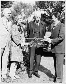
Photograph, Visit to Eltham College by Sir Rohan Delacombe and Cr. L. Clarke, 19 September 1973
The State Governor Sir Rohan Delacombe and Lady Delacombe visited the Shire of Eltham where they were entertained to a civic luncheon by the Shire President Cr. L. E. Clarke and councilors at the Panton Hill hotel and made a tour of the shire. Among the sites visited was Eltham College. Cr Les Clarke (right) is the architect and regarded as the founder of Eltham College which opened months later in February 1974. Man and woman on the left unknown.This photo forms part of a collection of photographs gathered by the Shire of Eltham for their centenary project book,"Pioneers and Painters: 100 years of the Shire of Eltham" by Alan Marshall (1971). The collection of over 500 images is held in partnership between Eltham District Historical Society and Yarra Plenty Regional Library (Eltham Library) and is now formally known as 'The Shire of Eltham Pioneers Photograph Collection.' It is significant in being the first community sourced collection representing the places and people of the Shire's first one hundred years.Digital imagesepp, shire of eltham pioneers photograph collection, eltham, governor of victoria, sir rohan delacombe, eltham college, les clarke, cr. l. clarke -
 Mission to Seafarers Victoria
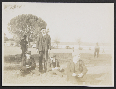
Photograph, Mr and Mrs Gurney Goldsmith, Resting, Easter Monday, Heatherbrae, 12 April 1909
Alfred Edward Clarke was a member of the Stock Exchange. He married a niece of Reverend Kerr Johnston, Margaret Helen Gowan (daughter of John Denovan Gowan, himself brother of Eliza Denovan Gowan) in 1886. His first wife, Caroline Long, died in 1884. One of his daughter, Linda Clarke (later married to John William Begg) was secretary of the Malvern branch of the Ladies' harbour Lights Guild. Article in the Standard (Port Melbourne, Vic. : 1884 - 1914), Saturday 17 April 1909, page 3 "SAILORS ENTERTAINED. Picnic at Glen Huntly. A very enjoyable picnic was held on Monday in connection with the Victoria Mission to Seamen, at Mr. Clarke's grounds, 'Heatherbrae,' Glen Huntly. About 90 sailors from ships in the Bay and river were entertained, and a happy time was spent. Tea was provided by ladies connected with the Mission, and cricket, football, and other sports were arranged and carried out with great zest. At the close of the day cheers were given for Mr. and Mrs. Clarke and family, the Mission workers, and all who had helped to make the outing a success."Small monochrome photograph depicting outdoor scene of a small number of men resting. Photograph somewhat faded, particularly on right side heatherbrae, easter, picnic, lhlg, caulfield, alfred edward clarke 1840-1913, margaret helen gowan 1863-1937, linda begg nee clarke 1877-1954, eliza johnston nee denovan gowan, john denovan gowan -
 Hume City Civic Collection
Photograph, c1900's
The foundation stone was laid on 29 August 1874 by the first wife of Sir William Clarke, ................. The building of Rupertswood was a most important event in the district history because .........................A black and white photograph of Rupertswood Mansion.rupertswood, rupertswood estate, clarke, william (sir), mckay, hugh victor, salesian college, schools, sunbury, salesian order, george evans collection -
 Beechworth RSL Sub-Branch
Article - Badge Returned from Active Service, 1942
Item issued to Corporal William Charles Clarke VX34546 2/24 Battalion who enlisted 26 June 1940 - Discharged 11 Oct 1945Bronze diamond shaped tri service badge with combined anchor, rising sun and wings surmounted by a king's crown; 2 attaching pin hole lugs on the reverse and 1 attaching pin; Underneath is a boomerang with the words 'RETURNED FROM ACTIVE SERVICE'. The reverse is stamped with the maker's details and the serial number 'A97811'.On a boomerang beneath Tri service emblem the words 'RETURNED FROM ACTIVE SERVICE'. The reverse is stamped with the maker's details Cluk/Melb/1942/ Issued by the CWTH GOVT and the serial number 'A97811'.badge, tri service emblem, returned from active service, bronze badge -
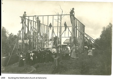 Mt Dandenong & District Historical Society Inc.
Photograph, Building the Methodist Church at Kalorama, 1909
The Methodist Church was built in 1910 by volunteer labour. Mainly through the efforts of the daughters of Eliza Hand and their families - the Jeeves, Walkers and Badenhops. (Lundy-Clarke manuscript)Local residents working to erect the frame of the Methodist Church on the Main Road (Ridge Road) at Kalorama. Eight workmen are on the frame with fifteen well dressed residents standing in front. 1910. Image received as a digital jpeg.Printed on front of photo: 1909 Building the Methodist Church at Kalorama church, kalorama methodist church, methodist church -
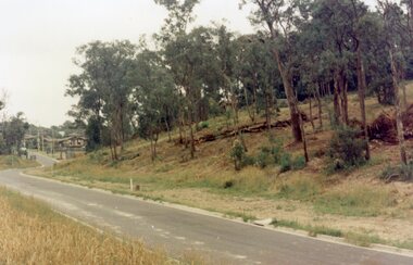
 Ringwood and District Historical Society
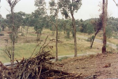
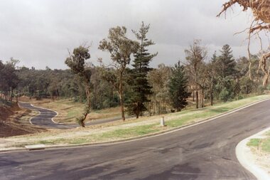
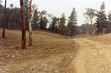
Photograph, View across junction of Wera (lower) and Manuelo (upper) Drives, North Ringwood showing how undergrowth had been cleared, February 1979
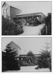
B552 N17 Part of a 51-photo record of the development of the "Kubis" Estate, Ringwood North, including road works to Debbie Place, Kubis Drive, Werac Drive, Manuelo Drive, Iluka Place and Glenvale Road. From the Jack Lundy Clarke collection. -
 Ringwood and District Historical Society
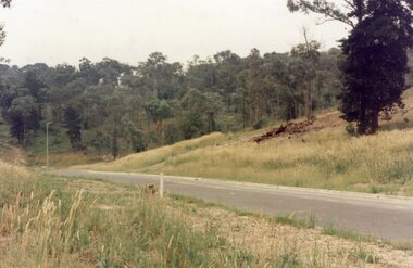
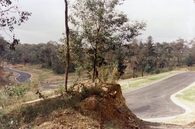
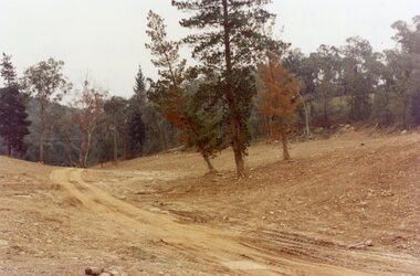
Photograph, Looking south up Werac Drive, North Ringwood past Manuelo Drive in February 1979
E552 N21 Part of a 51-photo record of the development of the "Kubis" Estate, Ringwood North, including road works to Debbie Place, Kubis Drive, Werac Drive, Manuelo Drive, Iluka Place and Glenvale Road. From the Jack Lundy Clarke collection. -
 Ringwood and District Historical Society
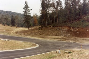
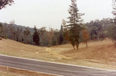
Photograph, Looking north down Werac Drive, North Ringwood with lake headwater's site behind light standard on left in February 1979
B552 N19 Part of a 51-photo record of the development of the "Kubis" Estate, Ringwood North, including road works to Debbie Place, Kubis Drive, Werac Drive, Manuelo Drive, Iluka Place and Glenvale Road. From the Jack Lundy Clarke collection. -
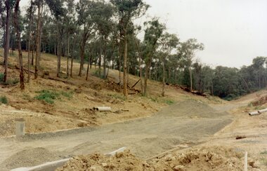 Ringwood and District Historical Society
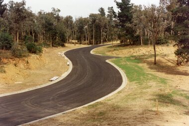
Photograph, The unfinished section of Debbie Place, North Ringwood in February 1979
E552 N23 Part of a 51-photo record of the development of the "Kubis" Estate, Ringwood North, including road works to Debbie Place, Kubis Drive, Werac Drive, Manuelo Drive, Iluka Place and Glenvale Road. From the Jack Lundy Clarke collection. -
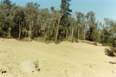
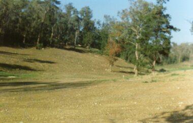 Ringwood and District Historical Society
Photograph, Site of the main body of Loughnan's Lake, North Ringwood on 10 June 1978. the rope tree was on the slope, far left
E550 N6 Part of a 51-photo record of the development of the "Kubis" Estate, Ringwood North, including road works to Debbie Place, Kubis Drive, Werac Drive, Manuelo Drive, Iluka Place and Glenvale Road. From the Jack Lundy Clarke collection. -
 Ringwood and District Historical Society
Photograph, Kubis Estate, North Ringwood on 16 June 1978, using the Kato as a crne to de-water final trench
E550 N9 Part of a 51-photo record of the development of the "Kubis" Estate, Ringwood North, including road works to Debbie Place, Kubis Drive, Werac Drive, Manuelo Drive, Iluka Place and Glenvale Road. From the Jack Lundy Clarke collection. -
 Ringwood and District Historical Society
Photograph, Kubis Estate, North Ringwood on 10 June 1978. Temporary end of Kubis Drive at junction with Debbie Place. The car stands at junction with Pamela Place
E550 N8 Part of a 51-photo record of the development of the "Kubis" Estate, Ringwood North, including road works to Debbie Place, Kubis Drive, Werac Drive, Manuelo Drive, Iluka Place and Glenvale Road. From the Jack Lundy Clarke collection. -
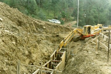
 Ringwood and District Historical Society
Photograph, Kubis Estate, North Ringwood on 16 June 1978. The Kato lifts a bucket out of the trench
E550 N11 Part of a 51-photo record of the development of the "Kubis" Estate, Ringwood North, including road works to Debbie Place, Kubis Drive, Werac Drive, Manuelo Drive, Iluka Place and Glenvale Road. From the Jack Lundy Clarke collection. -
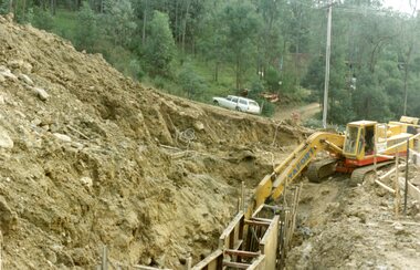
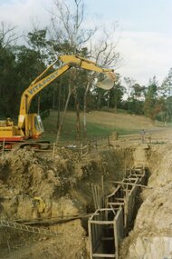
 Ringwood and District Historical Society
Photograph, Kubis Estate, North Ringwood on 16 June 1978. The concrete wall 27 feet deep at the pumping station in Glenvale Road
E550 N12 Part of a 51-photo record of the development of the "Kubis" Estate, Ringwood North, including road works to Debbie Place, Kubis Drive, Werac Drive, Manuelo Drive, Iluka Place and Glenvale Road. From the Jack Lundy Clarke collection. -
 Ringwood and District Historical Society
Photograph, Kubis Estate, North Ringwood in February 1978. The site of Loughnan's Lake seen from the north end of the wall. The rope tree was on the hillside on the left
E546 N2 Part of a 51-photo record of the development of the "Kubis" Estate, Ringwood North, including road works to Debbie Place, Kubis Drive, Werac Drive, Manuelo Drive, Iluka Place and Glenvale Road. From the Jack Lundy Clarke collection. -
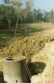
 Ringwood and District Historical Society
Photograph, Kubis Estate, North Ringwood on 16 June 1978. Kato working on final trench. The hole for the 27 feet deep well is seen beyond the trench
E550 N10 Part of a 51-photo record of the development of the "Kubis" Estate, Ringwood North, including road works to Debbie Place, Kubis Drive, Werac Drive, Manuelo Drive, Iluka Place and Glenvale Road. From the Jack Lundy Clarke collection. -
 Ringwood and District Historical Society
Photograph, Kubis Estate, North Ringwood in April 1978. View east up Kubis Drive from Jenkin Close past the foot of Werac Drive
E549 N16 Part of a 51-photo record of the development of the "Kubis" Estate, Ringwood North, including road works to Debbie Place, Kubis Drive, Werac Drive, Manuelo Drive, Iluka Place and Glenvale Road. From the Jack Lundy Clarke collection. -
 Ringwood and District Historical Society
Photograph, Kubis Estate, North Ringwood in April 1978. View east up Kubis Drive over Jenkin Close and intersection with Werac Drive
E549 N18 Part of a 51-photo record of the development of the "Kubis" Estate, Ringwood North, including road works to Debbie Place, Kubis Drive, Werac Drive, Manuelo Drive, Iluka Place and Glenvale Road. From the Jack Lundy Clarke collection. -
 Ringwood and District Historical Society
Photograph, Kubis Estate, North Ringwood in April 1978. Looking west across Kubis and Werac Drives over the full length of Loughnan's Lake site. Main pool was behind the lone pine
E548 N29 Part of a 51-photo record of the development of the "Kubis" Estate, Ringwood North, including road works to Debbie Place, Kubis Drive, Werac Drive, Manuelo Drive, Iluka Place and Glenvale Road. From the Jack Lundy Clarke collection. -
 Ringwood and District Historical Society
Photograph, Kubis Estate, North Ringwood in April 1978. Looking up the hill in Kubis Drive from the site of headwaters of Loughnan's Lake. Jenkins Close takes off to the right from centre
E548 N31 Part of a 51-photo record of the development of the "Kubis" Estate, Ringwood North, including road works to Debbie Place, Kubis Drive, Werac Drive, Manuelo Drive, Iluka Place and Glenvale Road. From the Jack Lundy Clarke collection. -
 Ringwood and District Historical Society
Photograph, Kubis Estate, North Ringwood in April 1978. Looking upstream from below the retaining wall of Loughnan's Lake that was where the truck tracks disappear. The wall was extended to the left across what was then a small gorge
E548 N19 Part of a 51-photo record of the development of the "Kubis" Estate, Ringwood North, including road works to Debbie Place, Kubis Drive, Werac Drive, Manuelo Drive, Iluka Place and Glenvale Road. From the Jack Lundy Clarke collection. -
 Ringwood and District Historical Society
Photograph, Kubis Estate, North Ringwood in April 1978. Looking west over site of Loughnan's Lake. The rope tree was on the slope to the right beyond the ridge with the lone pine
E548 N15 Part of a 51-photo record of the development of the "Kubis" Estate, Ringwood North, including road works to Debbie Place, Kubis Drive, Werac Drive, Manuelo Drive, Iluka Place and Glenvale Road. From the Jack Lundy Clarke collection. -
 Ringwood and District Historical Society
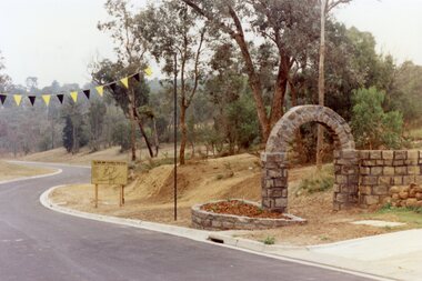
Photograph, Werac Drive, North Ringwood, entrance to Bel-Air Country Club in April 1978
E548 N11 Part of a 51-photo record of the development of the "Kubis" Estate, Ringwood North, including road works to Debbie Place, Kubis Drive, Werac Drive, Manuelo Drive, Iluka Place and Glenvale Road. From the Jack Lundy Clarke collection. -
 Ringwood and District Historical Society
Photograph, Loughnan Lake site over Kubis Drive, North Ringwood, on 14 April 1978. The retaining wall was where the car tracks disappear over the ridge where the spillway was
E548 N13 Part of a 51-photo record of the development of the "Kubis" Estate, Ringwood North, including road works to Debbie Place, Kubis Drive, Werac Drive, Manuelo Drive, Iluka Place and Glenvale Road. From the Jack Lundy Clarke collection.