Showing 753 items
matching construction plan
-
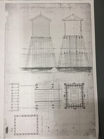 Queenscliffe Maritime Museum
Plan - Plan for a tide gauge house
An extract from the Board of Land and Works building estimates for 1858 shows an allocation of 500 Pounds for the construction of Tide Gauge Houses at various places. A copy of this plan was obtained from the Hydrographic Survey Office in Queenscliff. https://www.parliament.vic.gov.au/papers/govpub/VPARL1857-58NoB1.pdfCopy of a plan for a tide gauge house at Queenscliff 1858Clerk of works office Geelong 27 July 1858queenscliff, tide gauge house, plan -
 Bendigo Historical Society Inc.
Plan - SANDHURST BOYS CENTRE COLLECTION: SANDHURST TRAINING CENTRE ADMINISTRATION BUILDING FLOOR PLAN
Photocopy of the Administration building floor plan, showing Clinic, switch room, store, sick ward with patients toilet, utility and cleaners rooms, nurses station, pantry, doctors office, waiting room, locker rooms, reception foyer, general office, offices for chief training officer and secretary. Location unknown 16.02.2023.bendigo, institutions, sandhurst boys centre, victoria. ministry of housing and construction; sandhurst training centre; floor plan - administration building; -
 Bendigo Historical Society Inc.
Document - BERT GRAHAM COLLECTION: BENDIGO EAST SWIMMING CLUB
... , Plan for the construction of the Kiosk. This item quite large... Collection, Bendigo East Swimming Club, Plan for the construction ...Plans, Bert Graham Collection, Bendigo East Swimming Club, Plan for the construction of the Kiosk. This item quite large and has not been scanned.bendigo, clubs, bendigo east swimming pool -
 Bendigo Historical Society Inc.
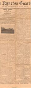
Newspaper - HILDA HILL COLLECTION: KYNETON GUARDIAN NEWSPAPER KYNETON CONVENT OF MERCY GOLDEN JUBILEE, 28th September, 1939
Hilda Hill Collection. The Kyneton Guardian Incorporating The Kyneton Observer Newspaper No. 10/317 Thursday, 28th September, 1939. Single Copy 2d. Front Page Kyneton Convent of Mercy celebrated it's Golden Jubilee (1889 - 1939), AMP Society Offering Families Super Plan for income at 60 with minimum investment of £3 or £4 per week, Also 3BO Bendigo Advertising The Radio Comedy Yes! What? On Monday, Tuesday & Wednesday Evenings from 8:30 pm - 8:45 pm, Paramount Theatre free screening car construction inside a modern factory.Kyneton Guardian, The Kyneton Observerhistory, kyneton, kyneton guardian 28/09/1939 -
 Ballarat Tramway Museum
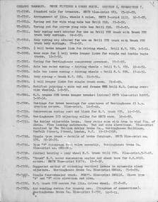
Document - List of drawings for Provincial tramways, State Electricity Commission of Victoria (SECV), c1950
Set of 15 typed sheets listing: 1 - Geelong tramways truck fittings and spare parts - 4 sheets 2 - Geelong track rail dimensions - 2 sheets 3 - Geelong track construction layout drawings - 6 sheets 4 - Bendigo - drawings of track sections - 1 sheet 5 - Bendigo - track plans - 1 sheet 6 - Bendogo - truck equipment and parts - 1 sheet Yields information about the drawings prepared by the SEC for Geelong and Bendigo - whether these still exist is questionable.Set of 15 typed quarto sheets within a manila card folder.tramcars, lists, geelong, bendigo, track work, plans, rails, parts, trucks, equipment -
 Ballarat Tramway Museum
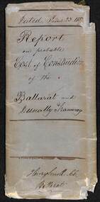
Document - Report, Henry Smith, "Report on probably cost of construction of the Ballarat and Dunolly Tramway", 23/6/1857
Report - 9 pages- handwritten, dated June 23 1857 to the Provincial Committee of the Ballarat and Dunolly Railway" Prepared by Henry Smith Civil Engineer, looks as various aspects of a prolapsed timber rail / sleepered tramway plated, horse drawn, grades, earthworks. Gives a total cost of 2897 pounds. Last page has a ink and washed sketch of the track structure - plan and cross section. Only the cover, first page and last page imaged.trams, tramways, tramways, costs, dunolly, timber tramways -
 Kew Historical Society Inc
Plan, Melbourne & Metropolitan Board of Works : Borough of Kew : Detail Plan No.1576, 1904
The Melbourne and Metropolitan Board of Works (MMBW) plans were produced from the 1890s to the 1950s. They were crucial to the design and development of Melbourne's sewerage and drainage system. The plans, at a scale of 40 feet to 1 inch (1:480), provide a detailed historical record of Melbourne streetscapes and environmental features. Each plan covers one or two street blocks (roughly six streets), showing details of buildings, including garden layouts and ownership boundaries, and features such as laneways, drains, bridges, parks, municipal boundaries and other prominent landmarks as they existed at the time each plan was produced. (Source: State Library of Victoria)This plan forms part of a large group of MMBW plans and maps that was donated to the Society by the Mr Poulter, City Engineer of the City of Kew in 1989. Within this collection, thirty-five hand-coloured plans, backed with linen, are of statewide significance as they include annotations that provide details of construction materials used in buildings in the first decade of the 20th century as well as additional information about land ownership and usage. The copies in the Public Record Office Victoria and the State Library of Victoria are monochrome versions which do not denote building materials so that the maps in this collection are invaluable and unique tools for researchers and heritage consultants. A number of the plans are not held in the collection of the State Library of Victoria so they have the additional attribute of rarity.Original survey plan, issued by the MMBW to a contractor with responsibility for constructing sewers in the area identified on the plan within the Borough of Kew. The plan was at some stage hand-coloured, possibly by the contractor, but more likely by officers working in the Engineering Department of the Borough and later Town, then City of Kew. The hand-coloured sections of buildings on the plan were used to denote masonry or brick constructions (pink), weatherboard constructions (yellow), and public buildings (grey). Development in the 20th century has irreparably altered that part of Kew represented in this plan. In the block bounded by Cotham Road, Charles Street, Wellington Street and Gellibrand; just one house standing in 1903 remains. This block included two of the most historic houses in Kew: ‘Ordsall’ (later ‘Southesk’) and ‘Madford’ (previously ‘Elm Lodge’). Ordsall was the home of the second chairman of Kew, John Halfey. It contained some of the most significant interior murals in Kew, created for Halfey by artists working for Cullen & Co. It was demolished in 1960 to make way for the Kew Civic Centre. Elm Lodge had been built for William Siddeley in ca. 1864. Arthur Septimus King purchased it in 1874. The lower paddocks of Madford were sold in 1905 by his wife to the Borough of Kew and, after landscaping by George and Thomas Pockett, opened as the Alexandra Gardens in 1908. Elm Lodge/Madford was in 1922 to become St. Anthony’s Home for Little Children before its subsequent demolition in the 1980s.melbourne and metropolitan board of works, detail plans, maps - borough of kew, mmbw 1576, cartography -
 Kew Historical Society Inc
Plan, Borough of Kew Detail Plan No.1577, 1904
The Melbourne and Metropolitan Board of Works (MMBW) plans were produced from the 1890s to the 1950s. They were crucial to the design and development of Melbourne's sewerage and drainage system. The plans, at a scale of 40 feet to 1 inch (1:480), provide a detailed historical record of Melbourne streetscapes and environmental features. Each plan covers one or two street blocks (roughly six streets), showing details of buildings, including garden layouts and ownership boundaries, and features such as laneways, drains, bridges, parks, municipal boundaries and other prominent landmarks as they existed at the time each plan was produced. (Source: State Library of Victoria)This plan forms part of a large group of MMBW plans and maps that was donated to the Society by the Mr Poulter, City Engineer of the City of Kew in 1989. Within this collection, thirty-five hand-coloured plans, backed with linen, are of statewide significance as they include annotations that provide details of construction materials used in buildings in the first decade of the 20th century as well as additional information about land ownership and usage. The copies in the Public Record Office Victoria and the State Library of Victoria are monochrome versions which do not denote building materials so that the maps in this collection are invaluable and unique tools for researchers and heritage consultants. A number of the plans are not held in the collection of the State Library of Victoria so they have the additional attribute of rarity.Original survey plan, issued by the MMBW to a contractor with responsibility for constructing sewers in the area identified on the plan within the Borough of Kew. The plan was at some stage hand-coloured, possibly by the contractor, but more likely by officers working in the Engineering Department of the Borough and later Town, then City of Kew. The hand-coloured sections of buildings on the plan were used to denote masonry or brick constructions (pink), weatherboard constructions (yellow), and public buildings (grey). MMBW Plan No.1577 includes some of the most significant houses in Kew: Herbert Henty’s ‘Roxeth’ (now part of Trinity Grammar), ‘Butleigh Wooton’, ‘Bokara’ and ‘Harrow’. It also includes the streets that have since changed their names. That part of College Parade linked to Glenferrie Road is now named College Place, College Parade now extends further north, and Charles Street did not yet reach Barkers Road. Roxeth is one of a number of Henty houses in Kew. Herbert Henty made his home here and was elected a member of Kew Municipal Council in 1864 and mayor in 1868-69. Walter Henry Serle, of Harrow served in the First World War. He was awarded the Military Medal ‘’For conspicuous bravery and devotion to duty. On 29th September near BELLICOURT he showed the greatest bravery and determination when his platoon was attacked by enemy bombing parties. It was due largely to his personal efforts that all the attacks were repulsed. Until wounded, his utter disregard of personal safety and boldness in dealing with the attacks were the means of saving the situation and were an inspiring example to his men.’melbourne and metropolitan board of works, detail plans, maps - borough of kew, mmbw 1577, cartography -
 Kew Historical Society Inc
Plan, Melbourne & Metropolitan Board of Works : Borough of Kew : Detail Plan No.1578, 1904
The Melbourne and Metropolitan Board of Works (MMBW) plans were produced from the 1890s to the 1950s. They were crucial to the design and development of Melbourne's sewerage and drainage system. The plans, at a scale of 40 feet to 1 inch (1:480), provide a detailed historical record of Melbourne streetscapes and environmental features. Each plan covers one or two street blocks (roughly six streets), showing details of buildings, including garden layouts and ownership boundaries, and features such as laneways, drains, bridges, parks, municipal boundaries and other prominent landmarks as they existed at the time each plan was produced. (Source: State Library of Victoria). This plan forms part of a large group of MMBW plans and maps that was donated to the Society by the Mr Poulter, City Engineer of the City of Kew in 1989. Within this collection, thirty-five hand-coloured plans, backed with linen, are of statewide significance as they include annotations that provide details of construction materials used in buildings in the first decade of the 20th century as well as additional information about land ownership and usage. The copies in the Public Record Office Victoria and the State Library of Victoria are monochrome versions which do not denote building materials so that the maps in this collection are invaluable and unique tools for researchers and heritage consultants. A number of the plans are not held in the collection of the State Library of Victoria so they have the additional attribute of rarity.Original survey plan, issued by the MMBW to a contractor with responsibility for constructing sewers in the area identified on the plan within the Borough of Kew. The plan was at some stage hand-coloured, possibly by the contractor, but more likely by officers working in the Engineering Department of the Borough and later Town, then City of Kew. The hand-coloured sections of buildings on the plan were used to denote masonry or brick constructions (pink), weatherboard constructions (yellow), and public buildings (grey). MMBW Plan No.1578 is significant in that it defines the extent of two private schools: Xavier College and Kew High School (now part of Trinity Grammar) by 1904. In relation to the latter, the plan clarifies which buildings the High School operated from behind the mansion ‘Molina’. Established in 1902, Trinity Grammar was to later lease and subsequently buy Molina (now ‘Merritt House’) and ‘Elsinore’ (now ‘Roberts House’). Xavier College had been established in 1872. This 1904 plan delineates the West Wing and the Great Hall (built in 1890).melbourne and metropolitan board of works, detail plans, maps - borough of kew, mmbw 1578, cartography -
 Kew Historical Society Inc
Plan, Melbourne & Metropolitan Board of Works. Borough of Kew Detail Plan No.1579, 1904
The Melbourne and Metropolitan Board of Works (MMBW) plans were produced from the 1890s to the 1950s. They were crucial to the design and development of Melbourne's sewerage and drainage system. The plans, at a scale of 40 feet to 1 inch (1:480), provide a detailed historical record of Melbourne streetscapes and environmental features. Each plan covers one or two street blocks (roughly six streets), showing details of buildings, including garden layouts and ownership boundaries, and features such as laneways, drains, bridges, parks, municipal boundaries and other prominent landmarks as they existed at the time each plan was produced. (Source: State Library of Victoria). This plan forms part of a large group of MMBW plans and maps that was donated to the Society by the Mr Poulter, City Engineer of the City of Kew in 1989. Within this collection, thirty-five hand-coloured plans, backed with linen, are of statewide significance as they include annotations that provide details of construction materials used in buildings in the first decade of the 20th century as well as additional information about land ownership and usage. The copies in the Public Record Office Victoria and the State Library of Victoria are monochrome versions which do not denote building materials so that the maps in this collection are invaluable and unique tools for researchers and heritage consultants. A number of the plans are not held in the collection of the State Library of Victoria so they have the additional attribute of rarity.Original survey plan, issued by the MMBW to a contractor with responsibility for constructing sewers in the area identified on the plan within the Borough of Kew. The plan was at some stage hand-coloured, possibly by the contractor, but more likely by officers working in the Engineering Department of the Borough and later Town, then City of Kew. The hand-coloured sections of buildings on the plan were used to denote masonry or brick constructions (pink), weatherboard constructions (yellow), and public buildings (grey). While MMBW Plan No.1579 does not include many buildings, those that it does show are significant to Kew’s history. These include the ‘Kew [Railway] Station’ in Denmark Street and the ‘Recreation Hall’ and rear courts off Wellington Street. The plan shows the outline of the Recreation Hall, constructed in 1880, at the rear of which is listed a bowling green, two tennis courts, a ‘skittle alley’ and a pavilion. When the Hall was first built, the Kew Cricket Club occupied an adjacent ground, however in 1885 this was acquired by the State Government as the future location of the Kew Railway Station. The Plan also shows a single oval at Xavier College. This oval was completed in 1883. One of the current ovals conforms to this oval’s original shape and position in the school grounds.melbourne and metropolitan board of works, detail plans, maps - borough of kew, mmbw 1579, cartography -
 Kew Historical Society Inc
Plan, Melbourne and Metropolitan Board of Works, Borough of Kew : Detail Plan No.1580, 1904
The Melbourne and Metropolitan Board of Works (MMBW) plans were produced from the 1890s to the 1950s. They were crucial to the design and development of Melbourne's sewerage and drainage system. The plans, at a scale of 40 feet to 1 inch (1:480), provide a detailed historical record of Melbourne streetscapes and environmental features. Each plan covers one or two street blocks (roughly six streets), showing details of buildings, including garden layouts and ownership boundaries, and features such as laneways, drains, bridges, parks, municipal boundaries and other prominent landmarks as they existed at the time each plan was produced. (Source: State Library of Victoria)This plan forms part of a large group of MMBW plans and maps that was donated to the Society by the Mr Poulter, City Engineer of the City of Kew in 1989. Within this collection, thirty-five hand-coloured plans, backed with linen, are of statewide significance as they include annotations that provide details of construction materials used in buildings in the first decade of the 20th century as well as additional information about land ownership and usage. The copies in the Public Record Office Victoria and the State Library of Victoria are monochrome versions which do not denote building materials so that the maps in this collection are invaluable and unique tools for researchers and heritage consultants. A number of the plans are not held in the collection of the State Library of Victoria so they have the additional attribute of rarity.Original survey plan, issued by the MMBW to a contractor with responsibility for constructing sewers in the area identified on the plan within the Borough of Kew. The plan was at some stage hand-coloured, possibly by the contractor, but more likely by officers working in the Engineering Department of the Borough and later Town, then City of Kew. The hand-coloured sections of buildings on the plan were used to denote masonry or brick constructions (pink), weatherboard constructions (yellow), and public buildings (grey). The area represented in this detail plan has undergone significant change during the 20th century. The widening of High Street in the 1930s and 1950s involved the shops on the south side of High Street being demolished and later rebuilt to fit the widened street. Another significant loss was the mansion ‘Drayton’ fronting Wellington Street, owned at this stage by Susannah Fenton. Her family name would later to be given to Fenton Way, which was to be built over the grounds of the house following its demolition. The plan of the garden is particularly interesting, containing a batten dome fronting Wellington Street, an ornamental pond, a fountain and a brick and glass conservatory. The notes by the plumbing contractor on this plan are particularly detailed. Pink borders delineate the ownership of the varying parcels of land. Some of the better known owners listed include the real estate agent Cr. Henry de Castres Kellett (bt) and John Padbury, the funeral director. This particular plan provides a clear view of the configuration of the Kew Junction in 1903 and the commercial buildings that surrounded it.melbourne and metropolitan board of works, detail plans, maps - borough of kew, mmbw 1580, cartography -
 Kew Historical Society Inc
Plan, Melbourne & Metropolitan Board of Works : Borough of Kew : Detail Plan No.1581, 1904
The Melbourne and Metropolitan Board of Works (MMBW) plans were produced from the 1890s to the 1950s. They were crucial to the design and development of Melbourne's sewerage and drainage system. The plans, at a scale of 40 feet to 1 inch (1:480), provide a detailed historical record of Melbourne streetscapes and environmental features. Each plan covers one or two street blocks (roughly six streets), showing details of buildings, including garden layouts and ownership boundaries, and features such as laneways, drains, bridges, parks, municipal boundaries and other prominent landmarks as they existed at the time each plan was produced. (Source: State Library of Victoria)This plan forms part of a large group of MMBW plans and maps that was donated to the Society by the Mr Poulter, City Engineer of the City of Kew in 1989. Within this collection, thirty-five hand-coloured plans, backed with linen, are of statewide significance as they include annotations that provide details of construction materials used in buildings in the first decade of the 20th century as well as additional information about land ownership and usage. The copies in the Public Record Office Victoria and the State Library of Victoria are monochrome versions which do not denote building materials so that the maps in this collection are invaluable and unique tools for researchers and heritage consultants. A number of the plans are not held in the collection of the State Library of Victoria so they have the additional attribute of rarity.Original survey plan, issued by the MMBW to a contractor with responsibility for constructing sewers in the area identified on the plan within the Borough of Kew. The plan was at some stage hand-coloured, possibly by the contractor, but more likely by officers working in the Engineering Department of the Borough and later Town, then City of Kew. The hand-coloured sections of buildings on the plan were used to denote masonry or brick constructions (pink), weatherboard constructions (yellow), and public buildings (grey). The streets and built structures in this plan were surveyed in 1903 and released to contractors in 1904. In addition to the designation of building types by colour, the plan includes detailed descriptions of land use and ownership. While many buildings remain from this period, a number of the buildings represented have been demolished including the original Kew Town Hall, and the Congregational and Roman Catholic churches in Walpole Street. While the mansion ‘Illapa’ in Princess Street is still extant – now part of ‘Rylands’ – the neighbouring mansion ‘Elsmere’ was demolished some decades ago. Rivalling Illapa and Elsmere in size were two mansions in Walpole Street, one named on the plan as ‘Gnarlbine’. Over time, Kew Junction and the south side of High Street have been reconfigured and widened, so that the commercial buildings on the corner of Princess and High Street no longer exist. A surprising feature of this part of central Kew to the northwest of Kew Junction is the amount of vacant land. In a number of cases, this land is noted by the contractor as used for vegetable gardens.melbourne and metropolitan board of works, detail plans, maps - borough of kew, mmbw 1581, cartography -
 Kew Historical Society Inc
Plan, Melbourne & Metropolitan Board of Works : Borough of Kew : Detail Plan No.1582, 1904
The Melbourne and Metropolitan Board of Works (MMBW) plans were produced from the 1890s to the 1950s. They were crucial to the design and development of Melbourne's sewerage and drainage system. The plans, at a scale of 40 feet to 1 inch (1:480), provide a detailed historical record of Melbourne streetscapes and environmental features. Each plan covers one or two street blocks (roughly six streets), showing details of buildings, including garden layouts and ownership boundaries, and features such as laneways, drains, bridges, parks, municipal boundaries and other prominent landmarks as they existed at the time each plan was produced. (Source: State Library of Victoria)This plan forms part of a large group of MMBW plans and maps that was donated to the Society by the Mr Poulter, City Engineer of the City of Kew in 1989. Within this collection, thirty-five hand-coloured plans, backed with linen, are of statewide significance as they include annotations that provide details of construction materials used in buildings in the first decade of the 20th century as well as additional information about land ownership and usage. The copies in the Public Record Office Victoria and the State Library of Victoria are monochrome versions which do not denote building materials so that the maps in this collection are invaluable and unique tools for researchers and heritage consultants. A number of the plans are not held in the collection of the State Library of Victoria so they have the additional attribute of rarity.Original survey plan, issued by the MMBW to a contractor with responsibility for constructing sewers in the area identified on the plan within the Borough of Kew. The plan was at some stage hand-coloured, possibly by the contractor, but more likely by officers working in the Engineering Department of the Borough and later Town, then City of Kew. The hand-coloured sections of buildings on the plan were used to denote masonry or brick constructions (pink), weatherboard constructions (yellow), and public buildings (grey). Public buildings, coloured grey on the Plan 1582 include the police station and post office, churches and schools. The earliest church school, Common School No.356 was located at the rear of the Congregational Church in Peel Street. It was constructed in 1859. The first buildings of Kew Primary School No.1075 on the other side of Peel Street were constructed in 1871. The school in 1903 only occupied a small fraction of its current site. In 1903, where the rear playground is now located, were two weatherboard and one brick villa. Trinity Grammar School was founded in 1902 and opened in the Parish Hall at the rear of Holy Trinity Anglican Church. It was not to move to its current site until 1906. The outline of the building housing the Kew Fire Brigade in the centre of the north side of Walton Street is shown but not named on the plan. Further down Pakington Street stood the two-storey Italianate mansion ‘Overton’. The home of Stanford Chapman, it was to be featured in the Imperial Institute series of bromide photographs of Victoria, Vol. 1: Homes and scenery. It was later to become a boarding house before it was later demolished.melbourne and metropolitan board of works, detail plans, maps - borough of kew, mmbw 1582, cartography -
 Kew Historical Society Inc
Plan, Melbourne & Metropolitan Board of Works : Borough of Kew : Detail Plan No.1585, 1904
The Melbourne and Metropolitan Board of Works (MMBW) plans were produced from the 1890s to the 1950s. They were crucial to the design and development of Melbourne's sewerage and drainage system. The plans, at a scale of 40 feet to 1 inch (1:480), provide a detailed historical record of Melbourne streetscapes and environmental features. Each plan covers one or two street blocks (roughly six streets), showing details of buildings, including garden layouts and ownership boundaries, and features such as laneways, drains, bridges, parks, municipal boundaries and other prominent landmarks as they existed at the time each plan was produced. (Source: State Library of Victoria)This plan forms part of a large group of MMBW plans and maps that was donated to the Society by the Mr Poulter, City Engineer of the City of Kew in 1989. Within this collection, thirty-five hand-coloured plans, backed with linen, are of statewide significance as they include annotations that provide details of construction materials used in buildings in the first decade of the 20th century as well as additional information about land ownership and usage. The copies in the Public Record Office Victoria and the State Library of Victoria are monochrome versions which do not denote building materials so that the maps in this collection are invaluable and unique tools for researchers and heritage consultants. A number of the plans are not held in the collection of the State Library of Victoria so they have the additional attribute of rarity.Original survey plan, issued by the MMBW to a contractor with responsibility for constructing sewers in the area identified on the plan within the Borough of Kew. The plan was at some stage hand-coloured, possibly by the contractor, but more likely by officers working in the Engineering Department of the Borough and later Town, then City of Kew. The hand-coloured sections of buildings on the plan were used to denote masonry or brick constructions (pink), weatherboard constructions (yellow), and public buildings (grey). This plan, which covers parts of High Street, Pakington Street and Derby Street is dominated by two historic Kew mansions: ‘Konetta’ and ‘Ramornie’. Ramornie was constructed in 1890 for James Maitland Campbell, three times Mayor of Kew. Sold in 1940, it became a boarding house known as ‘The Towers’. Now a private residence again, it has only one of its three balconies remaining. The location of the missing two balconies can be seen on the plan. In 1903, the grounds of Ramornie included a large tennis court fronting Pakington Street. The rear of the property is shown as extending to Cobden Street. One of Kew’s oldest hotels, the Prospect Hill Hotel on the corner of High and Cobden Street was established in 1858. The outline of the hotel shown on the plan represents the second building on the site. During the 19th century it was often used for electoral meetings. The Prospect Hill Hotel was to be redeveloped again in 1928, by the local architect Robert McIntyre. Since the 1980s, the hotel has been a live music venue, the home of the Melbourne Jazz Club, a restaurant and a liquor outlet.melbourne and metropolitan board of works, detail plans, maps - borough of kew, mmbw 1585, cartography -
 Kew Historical Society Inc
Plan, Melbourne & Metropolitan Board of Works : Borough of Kew : Detail Plan No.1588, 1904
The Melbourne and Metropolitan Board of Works (MMBW) plans were produced from the 1890s to the 1950s. They were crucial to the design and development of Melbourne's sewerage and drainage system. The plans, at a scale of 40 feet to 1 inch (1:480), provide a detailed historical record of Melbourne streetscapes and environmental features. Each plan covers one or two street blocks (roughly six streets), showing details of buildings, including garden layouts and ownership boundaries, and features such as laneways, drains, bridges, parks, municipal boundaries and other prominent landmarks as they existed at the time each plan was produced. (Source: State Library of Victoria)This plan forms part of a large group of MMBW plans and maps that was donated to the Society by the Mr Poulter, City Engineer of the City of Kew in 1989. Within this collection, thirty-five hand-coloured plans, backed with linen, are of statewide significance as they include annotations that provide details of construction materials used in buildings in the first decade of the 20th century as well as additional information about land ownership and usage. The copies in the Public Record Office Victoria and the State Library of Victoria are monochrome versions which do not denote building materials so that the maps in this collection are invaluable and unique tools for researchers and heritage consultants. A number of the plans are not held in the collection of the State Library of Victoria so they have the additional attribute of rarity.Original survey plan, issued by the MMBW to a contractor with responsibility for constructing sewers in the area identified on the plan within the Borough of Kew. The plan was at some stage hand-coloured, possibly by the contractor, but more likely by officers working in the Engineering Department of the Borough and later Town, then City of Kew. The hand-coloured sections of buildings on the plan were used to denote masonry or brick constructions (pink), weatherboard constructions (yellow), and public buildings (grey). This plan shows the original configuration of the Kew Post Office, Court House and Police Station, which had opened in 1888. This configuration was to essentially remain until the purchase of the Court House and Police Station by the City of Boroondara in 2007 and its subsequent renovation. Interestingly, the MMBW surveyors incorrectly labelled parts of the complex. In the triangle in front of the Post Office, before the erection of the Kew Cenotaph in 1925, was located a lawn and the Queen Victoria Jubilee Fountain. While many of the shops on the south side of High street had been constructed by 1903 a number of sites were still used as vegetable gardens. Further along High Street, on the corner of Charles Street, the Salvation Army Barracks can be seen on the plan. These Barracks predate the later Citadel and ‘Young People’s Hall’ that were opened in 1919. At 22 Charles Street can be seen the house of James Venn Morgan. Hailed as the ‘father of Kew’, Morgan arrived in Melbourne in 1840. He was first engaged as a bookmaker, but a fortunate venture on the goldfields enabled him to purchase land in Kew. He conducted a market garden and dairy in Kew for many years.melbourne and metropolitan board of works, detail plans, maps - borough of kew, mmbw 1588, cartography -
 Kew Historical Society Inc
Plan, Melbourne & Metropolitan Board of Works : Borough of Kew : Detail Plan No.1590, 1905
The Melbourne and Metropolitan Board of Works (MMBW) plans were produced from the 1890s to the 1950s. They were crucial to the design and development of Melbourne's sewerage and drainage system. The plans, at a scale of 40 feet to 1 inch (1:480), provide a detailed historical record of Melbourne streetscapes and environmental features. Each plan covers one or two street blocks (roughly six streets), showing details of buildings, including garden layouts and ownership boundaries, and features such as laneways, drains, bridges, parks, municipal boundaries and other prominent landmarks as they existed at the time each plan was produced. (Source: State Library of Victoria)This plan forms part of a large group of MMBW plans and maps that was donated to the Society by the Mr Poulter, City Engineer of the City of Kew in 1989. Within this collection, thirty-five hand-coloured plans, backed with linen, are of statewide significance as they include annotations that provide details of construction materials used in buildings in the first decade of the 20th century as well as additional information about land ownership and usage. The copies in the Public Record Office Victoria and the State Library of Victoria are monochrome versions which do not denote building materials so that the maps in this collection are invaluable and unique tools for researchers and heritage consultants. A number of the plans are not held in the collection of the State Library of Victoria so they have the additional attribute of rarity.Original survey plan, issued by the MMBW to a contractor with responsibility for constructing sewers in the area identified on the plan within the Borough of Kew. The plan was at some stage hand-coloured, possibly by the contractor, but more likely by officers working in the Engineering Department of the Borough and later Town, then City of Kew. The hand-coloured sections of buildings on the plan were used to denote masonry or brick constructions (pink), weatherboard constructions (yellow), and public buildings (grey). Surveyed by the Board of Works in 1903 and published in 1904, Plan No.1590 shows development north of Cotham Road. While this plan includes built structures in Mary Street, Cotham Road, High Street, Park Hill Road, Kent Street, Ridgeway Avenue, and Ermington Lane (now Ermington Place), only part of this section was notated and coloured in this contractor’s copy. Numerous houses, large and small are named on the plan: ‘Cholula’, ‘Belper’, ‘The Uplands’, ‘Spring Grove’ facing Cotham Road; ‘Marion’ facing Kent Street; and ‘Kia Ora’ facing Ridgeway Avenue.melbourne and metropolitan board of works, detail plans, mmbw 1590, survey plans - borough of kew, cartography -
 Kew Historical Society Inc
Plan, Melbourne & Metropolitan Board of Works : Borough of Kew : Detail Plan No.1591, 1905
The Melbourne and Metropolitan Board of Works (MMBW) plans were produced from the 1890s to the 1950s. They were crucial to the design and development of Melbourne's sewerage and drainage system. The plans, at a scale of 40 feet to 1 inch (1:480), provide a detailed historical record of Melbourne streetscapes and environmental features. Each plan covers one or two street blocks (roughly six streets), showing details of buildings, including garden layouts and ownership boundaries, and features such as laneways, drains, bridges, parks, municipal boundaries and other prominent landmarks as they existed at the time each plan was produced. (Source: State Library of Victoria)This plan forms part of a large group of MMBW plans and maps that was donated to the Society by the Mr Poulter, City Engineer of the City of Kew in 1989. Within this collection, thirty-five hand-coloured plans, backed with linen, are of statewide significance as they include annotations that provide details of construction materials used in buildings in the first decade of the 20th century as well as additional information about land ownership and usage. The copies in the Public Record Office Victoria and the State Library of Victoria are monochrome versions which do not denote building materials so that the maps in this collection are invaluable and unique tools for researchers and heritage consultants. A number of the plans are not held in the collection of the State Library of Victoria so they have the additional attribute of rarity.Original survey plan, issued by the MMBW to a contractor with responsibility for constructing sewers in the area identified on the plan within the Borough of Kew. The plan was at some stage hand-coloured, possibly by the contractor, but more likely by officers working in the Engineering Department of the Borough and later Town, then City of Kew. The hand-coloured sections of buildings on the plan were used to denote masonry or brick constructions (pink), weatherboard constructions (yellow), and public buildings (grey). That area of Kew bordered by Cotham Road, Park Hill Road, Ermington Lane (now Ermington Place), and Belmont Avenue contained some of the significant homes owned by Kew pioneers. Chief among these was ‘Park Hill’ on an enormous lot facing Park Hill Road. The Jubilee History of 1910 noted, six years after this plan was drawn, that: ‘Park Hill Road, forming the southern boundary of the cemetery, takes its name from Park Hill, the residence of Mr. Thomas Judd, who has resided there since December, 1852.’ Other named houses on the plan include ‘Ferndale’ facing Cotham Road; ‘Ermington’ adjacent to Judd’s Park Hill, facing Park Hill Road; and ‘Gilden’ and ‘Mont Belmont’ facing Belmont Avenue. Mont Belmont was designed by the architectural firm of Reed, Henderson and Smart for William George Lilley in 1887 and was completed in 1888. Lilley was Mayor of Kew in 1887-88, a Justice of the Peace and a member of the first Board of Guardians of Kew’s St. Hilary’s Church of England.melbourne and metropolitan board of works, detail plans, survey plans - borough of kew, mmbw 1591, cartography -
 Kew Historical Society Inc
Plan, Melbourne & Metropolitan Board of Works : Borough of Kew : Detail Plan No.1592, 1905
The Melbourne and Metropolitan Board of Works (MMBW) plans were produced from the 1890s to the 1950s. They were crucial to the design and development of Melbourne's sewerage and drainage system. The plans, at a scale of 40 feet to 1 inch (1:480), provide a detailed historical record of Melbourne streetscapes and environmental features. Each plan covers one or two street blocks (roughly six streets), showing details of buildings, including garden layouts and ownership boundaries, and features such as laneways, drains, bridges, parks, municipal boundaries and other prominent landmarks as they existed at the time each plan was produced. (Source: State Library of Victoria). This plan forms part of a large group of MMBW plans and maps that was donated to the Society by the Mr Poulter, City Engineer of the City of Kew in 1989. Within this collection, thirty-five hand-coloured plans, backed with linen, are of statewide significance as they include annotations that provide details of construction materials used in buildings in the first decade of the 20th century as well as additional information about land ownership and usage. The copies in the Public Record Office Victoria and the State Library of Victoria are monochrome versions which do not denote building materials so that the maps in this collection are invaluable and unique tools for researchers and heritage consultants. A number of the plans are not held in the collection of the State Library of Victoria so they have the additional attribute of rarity.Original survey plan, issued by the MMBW to a contractor with responsibility for constructing sewers in the area identified on the plan within the Borough of Kew. The plan was at some stage hand-coloured, possibly by the contractor, but more likely by officers working in the Engineering Department of the Borough and later Town, then City of Kew. The hand-coloured sections of buildings on the plan were used to denote masonry or brick constructions (pink), weatherboard constructions (yellow), and public buildings (grey). In MMBW Plan No.1592, the pink line indicates that area of the plan for which the contracting engineer was responsible. Included in the Plan are a number of primarily brick villas in a section of Belmont Avenue off Cotham Road. The house ‘Uvadale’ north of Belmont Avenue, and facing Cotham Road is also included in the contract. Excluded from the contract but shown on the Plan are ‘Glendonald’, ‘Mont Belmont’ and ‘Gilden’.melbourne and metropolitan board of works, detail plans, survey plans - borough of kew, mmbw 1592, cartography -
 Kew Historical Society Inc
Plan, Melbourne & Metropolitan Board of Works / Borough of Kew, Detail Plan No.1593, 1905
The Melbourne and Metropolitan Board of Works (MMBW) plans were produced from the 1890s to the 1950s. They were crucial to the design and development of Melbourne's sewerage and drainage system. The plans, at a scale of 40 feet to 1 inch (1:480), provide a detailed historical record of Melbourne streetscapes and environmental features. Each plan covers one or two street blocks (roughly six streets), showing details of buildings, including garden layouts and ownership boundaries, and features such as laneways, drains, bridges, parks, municipal boundaries and other prominent landmarks as they existed at the time each plan was produced. (Source: State Library of Victoria)This plan forms part of a large group of MMBW plans and maps that was donated to the Society by the Mr Poulter, City Engineer of the City of Kew in 1989. Within this collection, thirty-five hand-coloured plans, backed with linen, are of statewide significance as they include annotations that provide details of construction materials used in buildings in the first decade of the 20th century as well as additional information about land ownership and usage. The copies in the Public Record Office Victoria and the State Library of Victoria are monochrome versions which do not denote building materials so that the maps in this collection are invaluable and unique tools for researchers and heritage consultants. A number of the plans are not held in the collection of the State Library of Victoria so they have the additional attribute of rarity.Original survey plan, issued by the MMBW to a contractor with responsibility for constructing sewers in the area identified on the plan within the Borough of Kew. The plan was at some stage hand-coloured, possibly by the contractor, but more likely by officers working in the Engineering Department of the Borough and later Town, then City of Kew. The hand-coloured sections of buildings on the plan were used to denote masonry or brick constructions (pink), weatherboard constructions (yellow), and public buildings (grey). The laborious task of hand-tinting these Board of Works plans was not without hazards as is evidenced by Plan No. 1593. On the Plan, the original colourist spilt black and green ink, partially obscuring some parts. The most obvious casualty is ‘Clifton’ located on the corner of Cotham Road and Park Street [now Adeney Avenue]. Included in this Plan, and outlined in pink is that part of the section that the contracting engineer was tasked with completing. This included sewering on both sides of this part of Cotham Road, but excluded properties such as ‘Glendonald’ and ‘Monnington’. This area was to undergo a series of subdivisions including the ‘Clifton Estate’, which created housing lots on Adeney Avenue and Florence Avenue in 1916. The most notable occupant of Clifton was William Adeney [died 1893], a pioneer of Camperdown, after which Park Street was later renamed.melbourne and metropolitan board of works, detail plans, survey plans - borough of kew, mmbw 1593, cartography -
 Kew Historical Society Inc
Plan, Melbourne & Metropolitan Board of Works : Contour Plan of Melbourne & Suburbs : Melbourne Sewage, 1894
The Melbourne and Metropolitan Board of Works (MMBW) plans were produced from the 1890s to the 1950s. They were crucial to the design and development of Melbourne's sewerage and drainage system. This plan forms part of a large group of MMBW plans and maps that was donated to the Society by the Mr Poulter, City Engineer of the City of Kew in 1989. Within this collection, thirty-five hand-coloured plans, backed with linen, are of statewide significance as they include annotations that provide details of construction materials used in buildings in the first decade of the 20th century as well as additional information about land ownership and usage. The copies in the Public Record Office Victoria and the State Library of Victoria are monochrome versions which do not denote building materials so that the maps in this collection are invaluable and unique tools for researchers and heritage consultants. A number of the plans are not held in the collection of the State Library of Victoria so they have the additional attribute of rarity.Digital copy of an original MMBW plan. This contour plan shows the area identified by the MMBW for purposes of drainage and sewerage in 1894. The suburbs represented extend from Williamstown in the west to Bulleen in the east, and from Preston in the north, south to Sandringham. Suburbs are outlined in coloured ink. Red lines indicate main and branch sewers in existence at the beginning of 1894 in central and inner Melbourne. These extended as far as Williamstown and Brighton, but not yet as far as Kew, where sewering did not commence until 1901. Contour lines show the topography, which was important for indicating the fall of the land for the laying of sewers and drainage channels. Kew appears to be fairly undeveloped at this date except for railway lines and stations (the Kew and Outer Circle lines), main roads, the Kew Lunatic Asylum Reserve and Studley Park. However, the contour plan does not accurately represent the density of settlement, nor the large number of houses, which were being built in Kew and other suburbs from the 1850s to the land boom of the late 1880’s and early 1890’s. This plan is part of a large and historically significant group of MMBW plans and maps that was donated to the Society by the Mr Poulter, City Engineer of the City of Kew in 1989.mmbw contour plan of melbourne and suburbs, melbourne and metropolitan board of works, melbourne sewage, cartography -
 Kew Historical Society Inc
Photograph - W.B. Villa, Kew, c.1919
The photograph offers significant information relating to late Victorian / Federation colour schemes and fencing.The block fronted villa has a corrugated iron roof and a flat projecting verandah, ornamented with a trellis design of timber. The front window features a timber shade, mounted on brackets. The treatment of the block-fronted panels shows that there is an attempt to highlight imitation quoining through use of a darker colour. The windows and door are also in this darker shade. The front fence and gate are made of wooden pickets. It is unlikely that the photograph was taken at the time of the villa's construction given the size of the shrub/tree in the front garden.Subdivision plans are historically important documents used as evidence of the growth of suburbs in Australia. They frequently provide information about when the land was sold on which a built structure was subsequently constructed as well as evidence relating to surveyors and real estate and financial agents. The numerous subdivision plans in the Kew Historical Society's collection represent working documents, ranging from the initial sketches made in planning a subdivision to printed plans on which auctioneers or agents listed the prices for which individual lots were sold. In a number of cases, the reverse of a subdivision plan in the collection includes a photograph of a house that was also for sale by the agent. These photographs provide significant heritage information relating house design and decoration, fencing and household gardens.A real estate photograph, mounted on brown card, showing a double fronted weatherboard villa, located in Kew, Victoria. On the reverse of the photograph is a subdivision plan for the Altyre Estate.Stamped on mount: Top - "KEW. Close tram. Fine View. / W.B. Villa Containing 8 Rooms. / Up-to-date Conveniences. EL Etc." Below - "Land 40 x 165. 615 pounds. Sold"houses - kew, real estate photographs -
 Kew Historical Society Inc
Photograph - Cottage, probably East Kew, A. Aberline, 1920s
The Kew Historical Society's map collection includes a substantial number of real estate subdivision plans, mainly of Kew but also of surrounding suburbs in Melbourne. Most of the subdivision plans date from the 1920s and 1930s when the districts old homes and local farmland were being split up to accommodate residential growth in the postwar period. These early plans were assembled by a local firm, Jas R Mather & McMillan, which had an office in Cotham Road. Many of the plans, and sometimes photos, were annotated by the agents.Subdivision plans are historically important documents used as evidence for the growth of suburbs in Australia. They frequently provide information about when the land was sold as well as evidence relating to surveyors and real estate and financial agents. The numerous subdivision plans in the Kew Historical Society's collection represent working documents, ranging from the initial sketches made in planning a subdivision to printed plans on which auctioneers or agents listed the prices for which individual lots were sold. In a number of cases, the reverse of a subdivision plan in the collection includes a photograph of a house that was also for sale by the agent. These photographs provide significant heritage information relating house design and decoration, fencing and household gardens.The photograph may also be aesthetically significant depending on the importance of the photographic atelier.An elevated, modest weatherboard house, photographed towards the end of the construction phase. The lower section of the weatherboards are exposed and stained. The upper section is rendered with rough-cast. The tiled roof has a single gable that extends over the centrally placed front porch. On the porch, the door and single sidelight are filled with coloured leadlight whereas the casement windows in the front rooms contain plain glass. The leadlight and the wrought iron of the verandah are the only decorative elements of the utilitarian design. The location of the house, which was advertised for sale, has not to date been identified. The real estate photograph is mounted on the reverse of a subdivision plan for the Harvest Home Estate, Kew East.Photographer's stamp, lower right on mount: "A. Aberline, Glenferrie"houses - kew, bungalows - kew, real estate photographs -
 Kew Historical Society Inc
Document - Urban Planning Document, City of Kew, City of Kew : Minimum Size of Allotment Required, 1945-1955
A document outlining the relevant by-laws produced by the City Of Kew to regulate the minimum size of allotments in Barkers Road, Burke Road, Cotham Road, Glenferrie Road and Studley Park Road, as well as in other streets more generally. The by-laws specify the size of allotments in which single unit dwellings, attached houses and maisonettes, and flats could be built. In the ‘main streets’ a minimum land area for single unit dwellings was 8,100 square feet, with an average frontage of 60’ and a depth of 135’. In other streets this was reduced to an overall size of 6,250 square feet, with an average dimensions of 50’ x 125’. In specifying the land area required by flats, different sizes were regulated for the construction of between two and six flats. Six flats at the time when the regulations were passed must have been the upper limit permitted. Understanding the size of land listed in imperial measurements can be a challenge. Within Australia, the so-called quarter acre block was approximately 11,000 square feet. Those specified in the by-laws would appear to be smaller. The document was pasted on the reverse of a subdivision plan in the collection.This is a rare (undated) document produced by the City of Kew defining how subdivision within the municipality should occur. The document was created to constrain unbridled speculation in subdivisions in the various parts of Kew and East Kew.Undated typed document, issued by the City of Kew (1921-1994) indicating the minimum size of allotment required in Barkers Road, Burke Road, Cotham Road, Glenferrie Road and Studley Park Road. The document is mounted on board and waterstained. It was presumably used by a real estate agent. [Formerly catalogued as MAP.0066].city of kew - by-laws and regulations, subdivisions - kew - studley park -
Kew Historical Society Inc
Archive (Sub-series) - Subject File, Kew, City of - Management, 1958
City of KewReference, Research, InformationKHS Imposed OrderKew in Victoria was declared a City in 1921, and remained so until it was amalgamated into the City of Boroondara in 1994. This is a single large archive file, primarily comprised of Kew Council documents, a number of which date from an earlier period. Interesting early primary sources include: 1914 Amendments to the Local Government Act of 1903 [copy owned by Mr W.J. Muntz C.E.]; a Cleansing Contract [for the removal of night-soil] (1913); an Annual Statement of Accounts (1923); and By-Law No.66 (1939) [relating to the “Erection Construction and Removal of Buildings, Advertising Signs, Etc.”; and the Councillor’s Handbook (1939). In addition to these, later publications relate to Financial Statements (1986, 1987, 1988); Model Local Laws (1989); a Municipal Emergency Management Plan (1990); Mobile Bin Recycling Trial (1991); a School Project Kit (1991-2); and Committee Minutes (1992). There are also a number of newspaper articles/clippings on Council management issueslocal government - kew (vic) - publications, city of kew - management, city of kew - amendments to the local government act 1903, city of kew - by-laws, city of kew - financial statements, city of kew - councillor's handbook, city of kew - municipal emergency management plan 1990, city of kew - mobile bin recycling trial (1991)local government - kew (vic) - publications, city of kew - management, city of kew - amendments to the local government act 1903, city of kew - by-laws, city of kew - financial statements, city of kew - councillor's handbook, city of kew - municipal emergency management plan 1990, city of kew - mobile bin recycling trial (1991) -
Kew Historical Society Inc
Archive (Sub-series) - Subject File, Kew Historical Society, Hamer Court (Kew), 1972
... and original [very frail] plans for the construction of the hostel... and original [very frail] plans for the construction of the hostel ...Various partiesReference, Research, InformationSecondary Values (KHS Imposed Order)A large subject file containing material relating to Hamer Court Hostel for the Aged in Childers Street / High Street, Kew. The materials date from the early 1970s before Hamer Court was opened. The file contains correspondence to and from the Society and original [very frail] plans for the construction of the hostel (1972) and later plans for extensions (undated). Other original documents in the file include a programme for the official opening (of the extensions?) in 1983, agendas and minutes of meetings and promotional materials. Many of the items filed also relate to the Kew Elderly Citizens Association.kew historical society - archives, hamer court - high street - childers street - kew (vic), aged care - kew (vic)kew historical society - archives, hamer court - high street - childers street - kew (vic), aged care - kew (vic) -
 Kew Historical Society Inc
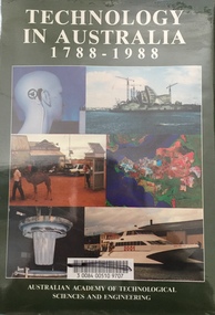
Book - Brown Gouge clothes brush, Australian Academy of Technological Sciences and Engineering, Technology in Australia, 1788-1988 : A condensed history of Australian technological innovation and adaptation during the first two hundred years, 1988
This book provides a history of technology in Australia from 1788 to 1988. There are twelve chapters by different authors. These chapters are: Innovation, science and the farmer (D.E. Tribe and L.J. Peel) Food technology (K.T.H. Farrer) Water and irrigation (K.D. Green) Forestry and forest products (W.H. Algar) Australian innovation in textile technology (D.S. Taylor) Engineering construction and building (J. Holland) Transport (B. Inglis) Communications and computers (J.H. Curtis and T. Pearcey) The chemical industry and Australian contributions to chemical technology (J.E. Kolm) The mineral industries (G.B. O'Malley) Energy (R.N. Morse) Manufacturing industry (P.N. Richards) Defence science and technology (J.L. Farrands and J.C. Wisdom) Index, photographs.Melbourne : Australian Academy of Technological Sciences and Engineering, c1988 xxix, 1017 p. : ill., maps, ports., plans, facsims. ; 26 cm. non-fictionThis book provides a history of technology in Australia from 1788 to 1988. There are twelve chapters by different authors. These chapters are: Innovation, science and the farmer (D.E. Tribe and L.J. Peel) Food technology (K.T.H. Farrer) Water and irrigation (K.D. Green) Forestry and forest products (W.H. Algar) Australian innovation in textile technology (D.S. Taylor) Engineering construction and building (J. Holland) Transport (B. Inglis) Communications and computers (J.H. Curtis and T. Pearcey) The chemical industry and Australian contributions to chemical technology (J.E. Kolm) The mineral industries (G.B. O'Malley) Energy (R.N. Morse) Manufacturing industry (P.N. Richards) Defence science and technology (J.L. Farrands and J.C. Wisdom) Index, photographs.technology -- australia -- history., technological innovations -- australia -- history. -
 Kew Historical Society Inc
Album - Photograph Album, Photographs of the Construction of the Kew Heights Synthetic Green April-May 2005, 2005
Sports Clubs in Kew in the final decades of the 19th century and in the early 20th century were often umbrella organisations with facilities for a number of sports. Typically in Kew, this included teams in lawn bowls, tennis and croquet. The Kew Bowling Club was formed in 1880 while the privately owned Auburn Heights Recreation Club was opened in 1904. By 1998, the two Clubs decided to amalgamate at the Auburn Heights site in Barkers Road, forming the Kew Heights Sports Club. The combined club was itself taken over by the Melbourne Cricket Club in 2012 becoming MCC Kew Sports Club. In 2017 MCC Kew closed and its landholding was subsequently sold to Carey Baptist Grammar School. Both the Kew and Auburn Heights Clubs assembled important collections. These historically significant and large collections were donated to the Society in 2020. The collections include manuscripts, pictures, trophies, plans, honour boards etc. The combined collections of the four sporting clubs making up the collection number hundreds of items that are historically significant locally. They are also significant to the sporting history of the greater Melbourne area and to the sports of lawn bowls and tennis in Australia in the 19th and 20th centuries. The collection illuminates two of the Victorian historic themes - 'Building community life' through forming community organisations and 'Shaping cultural and creative life' by participating in sport and recreation.Photographic album compiled by John Chapman about the construction of the synthetic green at Kew Heights Sports Club in 2005.PHOTOGRAPHS OF THE CONSTRUCTION OF THE KEW HEIGHTS SYNTHETIC GREEN APRIL-MAY 2005. PHOTOGRAPHED AND COMPILED BY JOHN CHAPMANkew heights sports club - 397 barkers road - kew (vic), bowling greens -
 Kew Historical Society Inc
Photograph - Yarra in Flood from Willsmere, North Kew, 1923
Flooding of the Yarra Valley, including that section of the Yarra bordering Kew and Kew East in the north and west of the municipality, was a regular occurrence. Extreme flood events of the Yarra River are recorded to have occurred in 1891, 1901, 1916, 1923 and 1934. The Municipality of Kew's response to these floods was to enact planning decisions restricting residential development in flood prone areas following the floods of 1916, 1921 and 1934. While floods continued after the development of the Upper Yarra Reservoir (construction 1948-57), the regularity and extent of these inundations diminished. Original, large sepia photograph showing men, women and children who have gathered on a grassy verge, probably farm land, to look out across the flooded Yarra Valley at Willsmere, North Kew. In the medium distance are three houses that are largely submerged by the flood waters as well as a number of Eucalypts. Judging by the clothes of the spectators, the date might be 1901 or 1916, but probably the latter due to the hats worn by a number of the women. Inscribed reverse: "Gift of Kerrie Woollard (KCC) (P)C.1923yarra river valley, kew east (vic.), floods, willsmere -
 Kew Historical Society Inc
Photograph - Flood at Fairfield Park, 1934
Flooding of the Yarra Valley, including that section of the Yarra bordering Kew and Kew East in the north and west of the municipality, was a regular occurrence. Extreme flood events of the Yarra River are recorded to have occurred in 1891, 1901, 1916, 1923 and 1934. The Municipality of Kew's response to these floods was to enact planning decisions restricting residential development in flood prone areas following the floods of 1916, 1921 and 1934. While floods continued after the development of the Upper Yarra Reservoir (construction 1948-57), the regularity and extent of these inundations diminished.Black and white print positive. Yarra River at Fairfield in 1934. Major flood resulting in submerged buildings in middle ground and onlookers on far bankReverse: "Flood of Yarra at Fairfield Park 1934"fairfield park, yarra valley, river yarra, floods -- 1934 -
 Kew Historical Society Inc
Photograph - Yarra in Flood, 1934
Flooding of the Yarra Valley, including that section of the Yarra bordering Kew and Kew East in the north and west of the municipality, was a regular occurrence. Extreme flood events of the Yarra River are recorded to have occurred in 1891, 1901, 1916, 1923 and 1934. The Municipality of Kew's response to these floods was to enact planning decisions restricting residential development in flood prone areas following the floods of 1916, 1921 and 1934. While floods continued after the development of the Upper Yarra Reservoir (construction 1948-57), the regularity and extent of these inundations diminished.Black and white print positive. 1934 floods of the Yarra Valley. Location Fairfield looking towards wooded hillside. Houses floating in river.Reverse: "From Fairfield Park (11936?) back towards hill (Wurundjeri Spur?)"floods -- 1934, yarra valley, yarra river, fairfield park