Showing 10042 items matching "dandenong"
-
 Melbourne Tram Museum
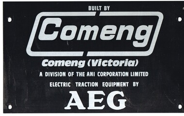
Sign - Builders' plate, Commonwealth Engineering - Comeng, C1980
Metal plate - aluminium - printed with black metal ink, Comeng Dandenong builders plate used on A or B class trams with AEG traction equipment.trams, tramways, builders plate, comeng, a class, b class, aeg -
 Ringwood and District Historical Society
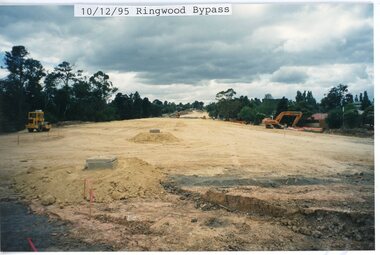
photograph, Eastlink Ringwood Bypass Construction-Ringwood Bypass 10/12/95
Colour photographWritten on back of photo: "Ringwood Bypass-Looking toward Mt Dandenong Rd" -
 Ringwood and District Historical Society
Legal record - Fire Insurance document (C.E.Carter), Fire Insurance - Commercial Union Assurance Co Ltd for Charles W Bruce, 1943
Standard form of Fire Insurance Policy issued by Commercial Union Assurance Co LtdPolicy issued to Charles W. Bruce, for dwelling in Mount Dandenong Road, Ringwood. -
 Melbourne Tram Museum
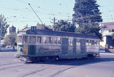
Slide - Set of 2, Les Fordham, Dec. 1963
hanimount light brown 35mm slides - December 1963 taken by Les Fordham of: .1 - W2 624, (East Brighton, route 64) turning from Dandenong Road into Hawthorn Road. Tram has adverts for Tolleys Brandy and AMP Life Insurance. .2 - W2 373, (East Brighton, route 64) outbound in Dandenong Road, possibly nearing Hawthorn Road.trams, tramways, dandenong road, caulfield, hawthorn road, tram 624, tram 373 -
 Ringwood and District Historical Society
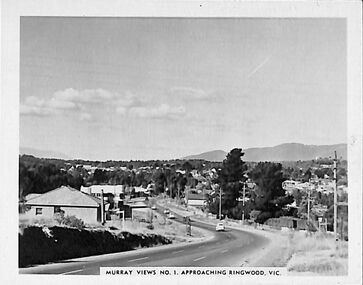
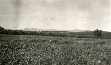
Photograph/Postcard, Souvenir photograph - Murray Views No.1 - Approaching Ringwood, Vic
Black & white "Murray Views" souvenir photograph - View towards Mt. Dandenong from Heatherdale Road along Maroondah Highway, Ringwood. Circa 1950s. -
 Whitehorse Historical Society Inc.
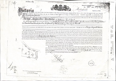
Document - Land Title, Certificate of Title, 01/05/1877
Certificate of Title issued to George Augustus Goodwin issued in 1877 for land adjacent to Dandenong Creek. Also copies of mortgages and eventual transfer to Annie Goodwingoodwin, george augustus, edwards, annie, dandenong creek, land settlement -
 Whitehorse Historical Society Inc.
Photograph, Jones Flower Farm
Jones Family Collection - NP2565 to NP2606. See also ND3831.Black and white photograph of daffodils growing on Jones' Flower Farm in Mt Pleasant Road, Nunawading, looking towards the Dandenongs with Mitcham Road in middle distance.jones, bette, walter, rolf, geoffrey, arthur, keith, lionel, muriel, jones flower farm, mount pleasant road nunawading -
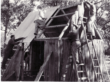
 Whitehorse Historical Society Inc.
Photograph, Schwerkolt Cottage Building the Blacksmith's Workshop, 1969
Black and white photo of Nunawading Apex Club members rebuilding barn moved from Dandenong to Schwerkolt Cottage. Now blacksmith's forge. 3 copies)schwerkolt cottage, apex club dandenong -
Southern Sherbrooke Historical Society Inc.
Book - Local History, Sassafras-Ferny Creek Fire Brigade, Hills Of Fire, 1992
pp viii, 76; 6 appendices & bibliography, footnotes, 1 map, photographs. A history of bushfires in the Dandenong Ranges and the Sassafras-Ferny Creek CFA Brigade.sassafras-ferny creek fire brigade, dandenong ranges, bushfires -
 Whitehorse Historical Society Inc.
Postcard, Historic Postcard - Set 2 no 5 - Boronia Road, c1920
Black and white historic postcard (Set 2 No 5 ) Boronia Road, Vermont approaching Dandenong Creek, Vermont in the 1920s. Photo supplied by Nunawading Historical Societydandenong creek, vermont, nunawading historical society, boronia road, vermont, nunawading library & information service -
 Whitehorse Historical Society Inc.
Photograph, Schwerkolt Cottage Building the Blacksmith's Workshop, 1969
Black and white photo of Nunawading Apex Club members erecting barn moved from the Dandenong Ranges to Schwerkolt Cottage. Now blacksmith's forge. 2 copiesschwerkolt cottage, apex club dandenong -
 Mt Dandenong & District Historical Society Inc.
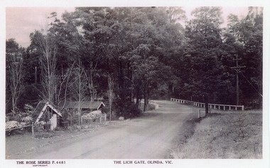
Photograph, The Lich Gate, Olinda, Vic, c1940s
Copy of Rose Series postcard #4481Copy of Rose Series postcard #4481. Mount Dandenong Road (Main Road) passing the picturesque Lich Gate on the left with Kenloch out of view on the right. c1940srose series, postcard, lich gate, olinda, kenloch, mt dandenong road, main road -
 Southern Sherbrooke Historical Society Inc.
Advertisement, U.S. Motors, Belgrave
Black and white advertisement (postcard?) for U.S. Motors.'See the Blue Dandenongs...make this Magnificent Conducted Scenic Tour by Luxurious Motor Coach' with a photo of a tourist bus. -
 University of Melbourne, Burnley Campus Archives
Photograph - Sepia print, Rural View, Unknown
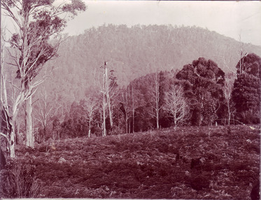
Sepia photograph. View with mountain and a road in the background. Possibly an excursion to Macedon or the Dandenongs. Photographs B91.409 to B91.417 appear to have come from the same photograph album.mountain, road, excursion, macedon, the dandenongs -
 Dandenong/Cranbourne RSL Sub Branch
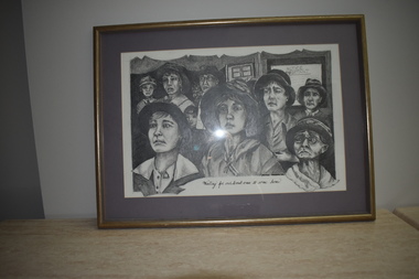
Work on paper - Waiting for our loved ones to come home, Waiting for our loved ones
Medium pencil drawing. People mainly women looking forlornly for their love ones to return from war. Drawing by Pamela Moulson 6 Cooma Crt Dandenong. Waiting for our loved ones to come home. -
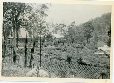
 Mt Dandenong & District Historical Society Inc.
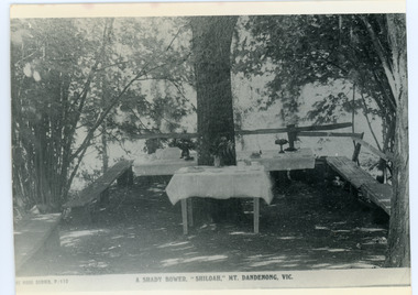
Photograph, Tea Tables at "Shiloah"
Originally the home of Isaac Jeeves, brother of Ellis Jeeves, ‘Shiloah’ was enlarged to take guests in the early 1900s. It was situated close to a beautiful fern gully and Isaac and his family capitalised on this by setting out walking tracks through the ferns. They charged 1/- to walk through and this included afternoon tea in a garden setting. ‘Shiloah’ was a popular tourist attraction but the making of the Olinda Creek Road destroyed the fern gullies and, by the 1930s, it was all finished. This photograph shows the tea tables at 'Shiloah' where Selina Jeeves and her daughter Elsie served afternoon tea to visitors.Black and white photograph taken from a Rose Series postcard showing tables set up in an exterior courtyard with bench seating.On front - Rose Series P. 170 A SHADY BOWER "SHILOAH" MT DANDENONG. VIC.shiloah, isaac jeeves the younger, guest house, afternoon tea, ferns, selina jeeves, elsie jeeves -
 Mt Dandenong & District Historical Society Inc.
Photograph, Harry Child's Hut, early 1900s
Home of Harry Child in foreground built on the southern boundary of his father's (Francis Matthew Child) allotment. Black and white photograph showing the home of Harry Child. This photograph has a detailed inscription on the back handwritten by John Lundy-Clarke.The eastern face of Mt Dandenong from F.M. Childs selection Cnr allotment D.francis matthew child, mt dandenong, harry child -
City of Kingston
Photograph - Black and white, 5 January 1984
Cheltenham and Heatherton are suburbs in the City of Kingston that were originally established as a rural market gardening community. The market gardens, farms and paddocks have gradually been sub-divided into housing and industrial estates and associated infrastructure such as schools and shopping facilities. This aerial image covers a diverse section of the City of Kingston, taking in the suburbs of Cheltenham, Heatherton, Mentone and Parkdale. By 1984, the market gardens of the district have been replaced by housing and factories. The Nylex factory is visible and now closed. Mentone Bowl on the corner of Warrigal Road and Nepean Highway has now been replaced by high rise apartments, another feature of the changing landscape in the City of Kingston. The vacant land now occupied by the Moorabbin Airport Direct factory Outlet (DFO) is also depicted.Aerial photograph of Cheltenham, Heatherton, Mentone and Parkdale within the City of Kingston. The area depicted in the 1984 aerial view includes Centre Dandenong Road and Cheltenham East Primary School (top left), Kingston Heath Reserve (top right), intersection of Lower Dandenong Road, Warrigal Road, Balcombe Road and Nepean Highway (bottom left), Balmoral Drive/McSwain Street Parkdale (bottom right).White text: 3831-179 Lens information [indecipherable] RINGWOOD M/S 7922-3 RUN 16 [Clockface image] 5,300' ASL VIC DLS© 5-1-84cheltenham, heatherton, mentone, parkdale, market gardens, urbanisation -
 Melbourne Tram Museum
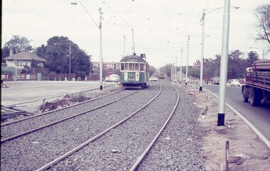
Slide, Keith Caldwell, March 1968?
Agfa colour blue white plastic mount, photo by Keith Caldwell of W2 455 outbound in Dandenong Road, route 5, Malvern Burke Road, during the construction phase of diverting Wellington St Prahran into Queensway. Slide not dated. Work to divert Dandenong Road completed Jan. 1968 (Timeline book). Photo possibly March 1968, which would match with the information on Reg Item 4313.trams, tramways, dandenong rd, route 5, malvern burke rd, w2 class, tram 455 -
 Whitehorse Historical Society Inc.
Document - Land Title, Land purchase, 31/07/1858
Record of land purchase by Louis Laurence Smith dated 31 July 1858. The land is adjacent to Dandenong Creek. Records of the transfer of the land in June 1895 are included. Photocopies.dandenong creek, smith, l l dr, william, gallien, jacque jean, speary, catherine, langdon, harry joseph, foster, john, youngman, edward, simmons, morris, mayfield, william george, marion, land sales -
 Whitehorse Historical Society Inc.
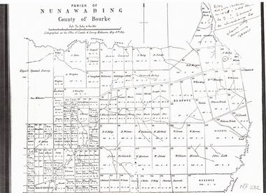
Document, Plan of Parish of Nunawading, 01/05/1864
Copy of plan of Parish of NunawadingCopy of plan of Parish of Nunawading, County of Bourke, lithographed at the Office of Lands and Survey, Melbourne, 13th May, 1864 showing boundaries of Koonung, Mullum Mullum and Dandenong Creeks.Copy of plan of Parish of Nunawadingland subdivision, parish of nunawading, county of bourke, elgars special survey, koonung creek, mullum mullum creek, dandenong creek -
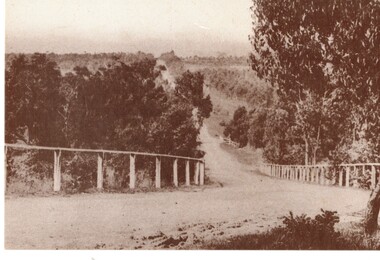
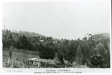 Mt Dandenong & District Historical Society Inc.
Photograph, Olinda, Victoria. Outlook to Ferntree Gully from Dulce Domun
Rose Series Postcard number 965Copy of Photo Series postcard #965 with view looking west to Mt Dandenong Road and Ridge Road. Looking across to where the Log Cabin (Kellys) would now be.mount dandenong, dulce domum, photo series -
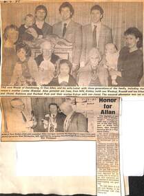 Dandenong & District Historical Society
Allan Family, Ken Allan - Family History and Newspaper Pics
Ken Allan, Mayor of DandenongMayor of Dandenongallan, allan ken, mayor, mayor of dandenong -
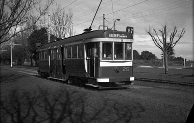 Melbourne Tram Museum
Negative - Set of 2 - Maximum Traction bogie trams Dandenong Road, Wal Jack, c1944
.1 - Black and white negative, by Wal Jack, of C 26 (St Kilda Beach via Dandenong road, Route 67), westbound in Dandenong Road. Appears to be a new sub-division on the other side of the road. .2 - ditto - C 35, note the building in front of the tram in the centre median strip. Photo not dated in the Wal Jack album. Possibly 14-9-42 based on other similar photos.trams, tramways, c class, dandenong road, route 67, tram 35, tram 26, world war ii -
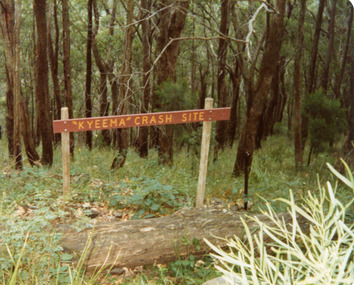 Mt Dandenong & District Historical Society Inc.
Photograph, Sign Indicating Kyeema Crash Site 1988, 1988
Simple wooden sign indicating the site of the Kyeema aircraft crash on the western slope of Mt Dandenong. The accident occurred on October 25th, 1938. All 18 onboard were killed.air crash, kyeema, mt dandenong -
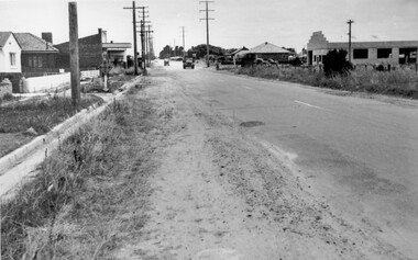 City of Kingston
Photograph - Black and white, c. 1950
While the road is sealed, there is evidence of potholes that have been filled, and the wide, gravel shoulder has long grass running into the gutter of the nature strip. On the other side of the road, extremely long grass can be seen growing on the side of the road. There is a truck visible on the road, which indicates the rural nature of the Cheltenham community in the 1950s.This image is one of many in the collections that focuses on the railway or roads. The development of roads and the railway was crucial to the ongoing development of the area. Black and white photograph of the intersection of Warrigal and Centre Dandenong roads, Cheltenham. On the left hand side is a small sign warning of a cross roads intersection. Housing and shops line the road.Handwritten in blue ink on reverse: 219 Handwritten in red ink on reverse: 80%cheltenham, roads, suburbs -
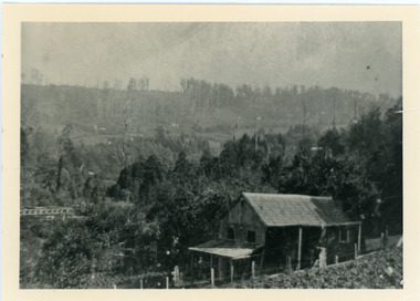
 Mt Dandenong & District Historical Society Inc.
Photograph, View of Kalorama Gap 1905
Kalorama Gap viewed from the South West in 1908. Ellis Jeeves' 'Mountjoy' is in the centre with the stables to the left. The raspberry patch belongs to Harry Walker and the building centre right to Edward Joseph Price. John Lundy-Clarke grew up in the Kalorama/Mt Dandenong area and later in life (1972-74) began to write a comprehensive history of the area working from an original settlement map in an effort to cover all areas.Black and white photograph showing an extensive raspberry crop in the foreground with a house and outbuilding in the centre and another dwelling centre right. Handwritten description on reverse by John Lundy-Clarke. 1908 view of Kalorama Gap taken from corner of Village Settlement LOTS 2 and 3 on Ridge (then Main Road) which crosses centre of picture with Walker’s driveway dropping left. Walker’s raspberry patch in foreground. “Mountjoy” in centre of picture with coaching stables on left. Price’s house and shop on right showing large cross room used by the Village Settlers for dancing. Mrs Hand’s “Beulah Tearooms” later Mt Dandenong North Post Office is above Price’s roof.kalorama gap, kalorama, harry walker, walker, edward joseph price, raspberry, mountjoy -
 Dandenong/Cranbourne RSL Sub Branch
Painting - Oil Painting
Oil painting of Ziggy Gizycki de GozdawaDonated to the Dandenong RSL Sub Branch in Dandenong Victoria. In memory of hr Dr Zygmunt Gizycki de Gozdawa MDDS (Poznan-Poland) BD Sc(Melb) LDS Vic by Gizycki de Gozdawa Family Heritage Foundation. -
 Ringwood and District Historical Society
Photograph, Civic Centre, Ringwood, 1970
Written on back of photograph, "Civic Centre, Ringwood, 1970" and "Mt. Dandenong Road just widened". -
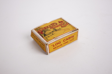 Dandenong/Cranbourne RSL Sub Branch
Memorabilia - Tobacco Packet, Log Cabin, Possibly circa 1940s
This item was found in a showcase at Dandenong RSL.Most 'roll your own' tobacco were sold in tins. There were 1 ounce and 2 ounce quantities that were sold in cardboard boxes such as this one.Small yellow and red packet for holding tobaccoLog Cabin / Flaked Gold Leaf / Tobacco / Medium Fine Cuttobacco