Showing 485 items
matching national government
-
 Forests Commission Retired Personnel Association (FCRPA)
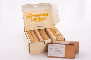
Commercial timbers of Victoria, Sample Box
Some decades ago a card sorting set for the identification and description of Australian timbers was developed for timber species which were available commercially and were in common usage, by the Commonwealth of Australia (CSIRO, Division of Forest Products) To complement and inform this national timber set each State or Territory developed reference timber sets of representative species. The Commercial Timbers of Victoria set was Victoria’s most recent (circa 1984) expression of this Victorian timber samples were sourced from logs selected by Forest Commission of Victoria (FCV) District Foresters and milled locally. Kiln drying and machining was carried out at timber producers Row, Web and Anderson, in Port Melbourne. Labeling and boxing was done by FCV Timber Inspectors, with box and booklet design and graphics handled in-house More recent timber samples were badged as Conservation Forests & Lands, reflecting historical government restructuring in the early 1980s Info: Simon MurphyProvided the public, industry (timber and associated), and educational facilities with a reference collection of notable Victorian timbers. Initially in a reduced format from 1940-50s, with boxed sets produced from 1981 until 1984A boxed set of timber samples representing the 20 tree species that were considered to be the most notable in Victoria. The set also includes an information booklet. Each timber specimen has information on species, occurrence, uses and physical properties Produced for sale by the the FCV and later by the Department of Conservation Forests and Lands. (CFL). forests commission victoria (fcv) -
 Healesville Sanctuary Heritage Centre
Newspaper - Cutting, The Herald, Melbourne, Govt. Pledge on Sanctuary, 5 July 1950
The Premier state that the Government will encourage those who want to preserve our national assets. Collected from State Library Melbourne Victoria.Photocopy.non-fictionThe Premier state that the Government will encourage those who want to preserve our national assets. Collected from State Library Melbourne Victoria.1950s -
 Victorian Railway History Library
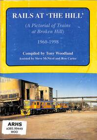
Book, McNicol, Steve, Rails At 'The Hill': A Pictorial of Trains at Broken Hill 1960-1998, 1999
... including New South Wales Government Railways, National Rail ...A pictorial of trains at Broken Hill including New South Wales Government Railways, National Rail and Silverton Tramway.ill, p.32.non-fictionA pictorial of trains at Broken Hill including New South Wales Government Railways, National Rail and Silverton Tramway.railroad operations - new south wales - pictorial works, tramways - broken hill -
 St Kilda Historical Society
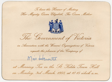
Ephemera - Invitation, Women's Organizations of Victoria Morning Tea, 1958
Invitation issued to Miss Hewitt of the National Council of Women, Victoria to attend a morning tea at St Kilda Town Hall on 3 March 1958 during the 1958 visit by Queen Elizabeth, The Queen Mother. The event was hosted by the Government of Victoria in association with the Women's Organizations of Victoria. The Queen Mother was in Australia over the period 14 February – 7 March 1958 to attend the British Empire Service League Conference in Canberra and visit Brisbane, Sydney, Melbourne, Tasmania, Adelaide and Perth, and various provincial and country areas. White coloured card, discoloured with age, printed and edged in gold, with a blue Victorian Coat of Arms. Annotated in handwriting, in blue ink, with the name of the invitee.Miss Hewittroyal visits, queen elizabeth the queen mother, queen mother, national council of women of victoria -
 Wodonga & District Historical Society Inc
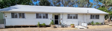
Photograph - Hut 97 Bonegilla Migrant Experience
Bonegilla Army Base and Migrant Reception Centre began when funds were allocated to build Bonegilla Army Camp in June 1940. Builders began to erect about 600 huts prior to the Army moving in during September of that year. Between 1942 - 1943 it was enlarged to 848 buildings. In 1947 Bonegilla Reception and Training Centre began operating with the Army providing transport, security and catering services. From 1949 until 1965 the Bonegilla Reception and Training Centre operated without a military presence. Bonegilla Migrant Reception and Training Centre was made up of 24 blocks. It had its own churches, banks, sporting fields, cinema, hospital, police station and railway platform. It became the largest and longest operating reception centre in the post-war era. More than 300,000 migrants passed through its doors between 1947 and 1971, with most of those originating from non-English speaking European countries. From1965 with the increased Australian commitment to the Vietnam War and the need to find accommodation to train National Servicemen for Vietnam, the Army negotiated with the Department of Immigration to take over several blocks at Bonegilla. In 1971 the Reception Centre closed and the site reverted to the Army. After 1971 the Army undertook a major site redevelopment with the construction of Latchford Barracks as the Army Apprentice School. Later Latchford Barracks was redeveloped into part of the Army Logistic Training Centre. Between 1978 and 1982, nearly all of the centre was demolished in a major redevelopment. The new replacement buildings were formally opened as Latchford Barracks in 1983. Demolition of the buildings prompted calls for recognition of the site and the role it had played in Australia’s post-World War II Immigration program. After much discussion between the Department of Army and Heritage and local groups about the significance of the site, the Australian Heritage Commission proceeded with its listing on the Register of the National Estate. A Conservation Management Plan was prepared for Block 19 in 1996. The Army transferred Block 19 to the Victorian Government. In 2002 Heritage Victoria listed Block 19 on the State Heritage Register, giving attention to both the migrant and army connections with the site. Hut 97 at Bonegilla Migrant Experience is the home of the Wodonga & District Historical Society Inc.This image is significant because it records a building which is part of the Bonegilla Migrant Reception Centre which played a critical role as the largest and longest operating Migrant Reception Centre in Australia.A colour photo of Hut 97 at Block 19, Bonegilla Migrant Experience, now the home of Wodonga & District Historical Society Inc.hut 97 bonegilla migrant experience, wodonga & district historical society, immigration australia -
Glen Eira Historical Society
Document - Historic Conservation Areas Project
Contains 4 items relating to historic conservation: 1/Five newsletters (one page each newsletter, dated 07/1975, 08/1975, 09/1975, 10/1975 and the final one 12/1975) describing how the project evolved, project funds, progress, study method, project 1 report, project 2 report and summary as no further funds available. Project was to include all of Melbourne but funding did not allow this. Note: newsletters stamped with Caulfield Historical Society. 2/Letter (one page on official city of Caulfield letterhead) from Andrew Rodda (manager planning) to Hazal Ford (dated 13/11/1989) describing ‘council resolved on 18/07/1989 to proceed with preliminary conservation survey’ and mentions that a copy is included. 3/Preliminary conservation survey for the City of Caulfield (nine pages) describing background, study area, budget, purpose, study outline, timeframe, report format, ownership, tasks and background information (mentions number and types of houses and properties as at 1986 and 1988) and a map of City of Caulfield. 4/Booklet (28 pages) titled ‘Heritage Area – Caulfield North Draft Heritage Guidelines July 1999 – City of Glen Eira’, containing Caulfield North Heritage Area, cultural heritage, Heritage Overlay Area, architectural description, common architectural forms and features, development guidelines, key design checklist. It includes a map of the Caulfield North Heritage Overlay Area, two illustrations about the development envelope and many black-and-white photographs of houses and architectural features.historic conservation areas project niven barbara, newsletters, town planning, historic buildings, heritage studies, housing, royal historical society of victoria (rhsv), read michael, plans, local government, historical societies, committee for urban action (cua), national trust, hopkins sherry ms., ford hazel, preliminary conservation survey, town planning, heritage studies, rodda andrew, city of caulfield, housing estates, victoria national estate grants program, australia icomos, burra charter, buildings structures and establishments, land surveys, suburbs, historic buildings, architectural significance, ‘caulfield’s heritage study’, soloman geulah dr., caulfield library, dandenong road, nepean highway, hotham street, iknerman road, orrong road, north road, poath road, ‘plan of the city of caulfield’, north ward, east ward, south ward, west ward, kooyong road, neerim road, bambra road, balaclava road, shire of caulfield, railways, world war 1914-1918, depression 1929-1939, rippon lea, labassa, parks, mansions, community services, ‘caulfield north draft heritage guidelines july 1999’, city of glen eira, caulfield north heritage area, glen eira heritage management plan, mayfield grove, normanby avenue, carnarvon street, glenferrie street, arthur street, malakoff street, normanby road, heritage advisory service, construction materials, victorian style, mediterranean style, spanish mission style, californian bungalow style, federation style, architectural style, architectural features, heritage conservation design, building construction, building regulations, aboriginal peoples, carnarvon road -
Port Melbourne Historical & Preservation Society
Document - Collection of letters relating to the Post WW2 Monetary Reconstruction, 1941 - 1947
Sydney William NEWMAN was active in organisations including The Australian People's Movement, the New Economics Association, The Douglas National Credit Movement, The Melbourne Economic Research Council & the International Monetary & Reconstruction Fund.A collection of 23 letters between various Commonwealth Government Departments and Sydney William NEWMAN, Engineer of Dow Street, Port Melbourne. Mr Newman was the Hon. Secretary of The Melbourne Economic Research Council. Written mainly during 1941 & 44 the correspondence deals with post WW2 economic reconstruction. The earlier letters are from the Department of Labour & National Service but later from various members of the Federal Parliament, including Dame Enid LYONS.banking, the melbourne economic research council, international monetary & reconstruction fund, dame enid lyons, sydney william newman, the australian people's movement, new economics association, the douglas national credit movement -
 Federation University Art Collection
Drawing, Alun Leach-Junes, 'Sea Wall at Night (The Mumbles)' by Alun Leach-Jones, 1994
Alun LEACH-JONES (1937-24 December 2017) Born Maghull, Lancashire, United Kingdom Arrived Australia 1960 Alun Leach-Jones is recognised as one of Australia's leading abstract colour painters. He spent his childhood in the Welsh village of Glasfryn, Denbighshire. At the age of 14 he started a three year apprenticeship with the Solicitors Law Society, Liverpool illuminating manuscripts and hand copying legal documents. While working with the law society Leach-Jones studied painting and drawing in the evenings at the Liverpool College of Art between the years 1955-57. He immigrated to Australia in 1960, settling in Adelaide and attending the South Australian School of Art, after which he travelled and exhibited throughout Australia and abroad. In 1966 Leach-Jones celebrated Noumenon series was shown with Australian Galleries in Melbourne and he was immediately recognised as being part of what was then labelled as ‘the New Abstraction’ in Australian art. Later in 1968 his work was included in the influential exhibition "The Field" held at the National Gallery of Victoria. This item is part of the Federation University Art Collection. The Art Collection features over 2000 works and was listed as a 'Ballarat Treasure' in 2007.Pastel drawing on Stonehenge paper. Donated through the Australian Government's Cultural Gifts Program by David Thomas and Brenda Martin, 2011Signed verso lower left 'A. Leach-Jones'art, artwork, leach-jones, alun leach-jones, cultural gifts program, new abstraction, the field -
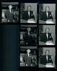
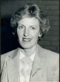 Vision Australia
Photograph - Image, Diana Jones with tennis pin, 1985
Diana Jones (1939-2009) was President of the Association for the Blind from 1985 until 1992. In her 8 years as President a great deal was accomplished. New centres were opened or extended throughout Victoria and the Metropolitan area, volunteer services expanded and the Vision Resource Centre at Kooyong was built into which 3RPH radio was relocated. A Vision Information hotline, audiology services and the National Centre for Ageing and Sensory Loss were established, the Braille and Talking Book libraries was incorporated into the Association and the Charlie Bradley Cricket Pavilion opened at Kooyong. In 1990 Diana Jones became a member of the first Board of Directors of the newly incorporated Association for the Blind Ltd which ushered in a new era, requiring strict observance of financial and accounting methods in order to ensure continued Government funding. Mrs Jones was highly regarded by clients, volunteers and staff as a capable hard-working leader. Her services to the Association and over many years to the wider community, were recognised in her appointment as a Member of the Order of Australia in the 1993 Queen's Birthday Honours. In this image she stands inside, with a brick wall behind her, wearing a suede jacket, diamond pattern jumper, white shirt and a jewelled tennis racquet pin on her lapel.Diana Jones wearing a jacket, diamond patterned jumper and tennis racquet pin on her lapel1404.2 and 1404.3 on backdiana jones, association for the blind -
 Vision Australia
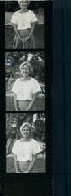
Photograph - Image, Diana Jones - black and white prints, 1980s
Diana Jones (1939-2009) was President of the Association for the Blind from 1985 until 1992. In her 8 years as President a great deal was accomplished. New centres were opened or extended throughout Victoria and the Metropolitan area, volunteer services expanded and the Vision Resource Centre at Kooyong was built into which 3RPH radio was relocated. A Vision Information hotline, audiology services and the National Centre for Ageing and Sensory Loss were established, the Braille and Talking Book libraries was incorporated into the Association and the Charlie Bradley Cricket Pavilion opened at Kooyong. In 1990 Diana Jones became a member of the first Board of Directors of the newly incorporated Association for the Blind Ltd which ushered in a new era, requiring strict observance of financial and accounting methods in order to ensure continued Government funding. Mrs Jones was highly regarded by clients, volunteers and staff as a capable hard-working leader. Her services to the Association and over many years to the wider community, were recognised in her appointment as a Member of the Order of Australia in the 1993 Queen's Birthday Honours. In these images she is standing outside Brighton (?) wearing a pleated skirt, a white top with banding on the short sleeve edges, across the neckline and mid-chest with a zig zag pattern between the lines. She has on thick hoop earrings and a long chain with a pendant possibly shaped like a genie bottle.Portrait of Diana Jones in various sizesdiana jones, association for the blind -
 Vision Australia
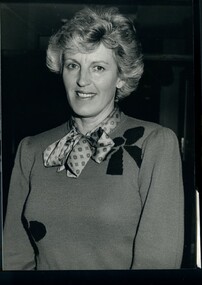
Photograph - Image, General Committee President Diana Jones, 1986
Diana Jones (1939-2009) was President of the Association for the Blind from 1985 until 1992. In her 8 years as President a great deal was accomplished. New centres were opened or extended throughout Victoria and the Metropolitan area, volunteer services expanded and the Vision Resource Centre at Kooyong was built into which 3RPH radio was relocated. A Vision Information hotline, audiology services and the National Centre for Ageing and Sensory Loss were established, the Braille and Talking Book libraries was incorporated into the Association and the Charlie Bradley Cricket Pavilion opened at Kooyong. In 1990 Diana Jones became a member of the first Board of Directors of the newly incorporated Association for the Blind Ltd which ushered in a new era, requiring strict observance of financial and accounting methods in order to ensure continued Government funding. Mrs Jones was highly regarded by clients, volunteers and staff as a capable hard-working leader. Her services to the Association and over many years to the wider community, were recognised in her appointment as a Member of the Order of Australia in the 1993 Queen's Birthday Honours. In this image she stands inside, wearing a knit jumper with bow ties and a patterned blouse with tied neckline.Diana Jones wearing a knit jumper with bows, and patterned blouse with tied necklineGeneral Committee President Diana Jones 1404.5diana jones, association for the blind -
 Vision Australia
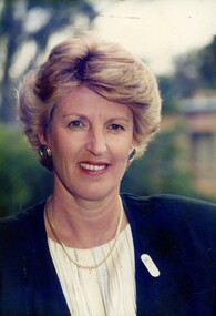
Photograph - Image, Diana Jones in blue suit, 1989
Diana Jones (1939-2009) was President of the Association for the Blind from 1985 until 1992. In her 8 years as President a great deal was accomplished. New centres were opened or extended throughout Victoria and the Metropolitan area, volunteer services expanded and the Vision Resource Centre at Kooyong was built into which 3RPH radio was relocated. A Vision Information hotline, audiology services and the National Centre for Ageing and Sensory Loss were established, the Braille and Talking Book libraries was incorporated into the Association and the Charlie Bradley Cricket Pavilion opened at Kooyong. In 1990 Diana Jones became a member of the first Board of Directors of the newly incorporated Association for the Blind Ltd which ushered in a new era, requiring strict observance of financial and accounting methods in order to ensure continued Government funding. Mrs Jones was highly regarded by clients, volunteers and staff as a capable hard-working leader. Her services to the Association and over many years to the wider community, were recognised in her appointment as a Member of the Order of Australia in the 1993 Queen's Birthday Honours. In this image she wears a blue jacket, striped blouse, gold curb chain necklace, round earrings and elongated oval badgeDiana Jones ina blue jacket, striped blouse, gold curb chain necklace, round earrings and elongated oval badgeP1405.2 1 Diana Jonesdiana jones, association for the blind -
 Vision Australia
Photograph - Image, Diana Jones at her desk and getting out of her car, 4/7/1991
Diana Jones (1939-2009) was President of the Association for the Blind from 1985 until 1992. In her 8 years as President a great deal was accomplished. New centres were opened or extended throughout Victoria and the Metropolitan area, volunteer services expanded and the Vision Resource Centre at Kooyong was built into which 3RPH radio was relocated. A Vision Information hotline, audiology services and the National Centre for Ageing and Sensory Loss were established, the Braille and Talking Book libraries was incorporated into the Association and the Charlie Bradley Cricket Pavilion opened at Kooyong. In 1990 Diana Jones became a member of the first Board of Directors of the newly incorporated Association for the Blind Ltd which ushered in a new era, requiring strict observance of financial and accounting methods in order to ensure continued Government funding. Mrs Jones was highly regarded by clients, volunteers and staff as a capable hard-working leader. Her services to the Association and over many years to the wider community, were recognised in her appointment as a Member of the Order of Australia in the 1993 Queen's Birthday Honours. In these images she wears a pinstripe, double breasted jacket, patterned blouse, gold curb chain necklace and round earrings. As well as a proof sheet, the album also contains transparencies of the same photo shoot (not scanned).Diana Jones in a pinstripe, double breasted jacket, patterned blouse, gold curb chain necklace and round earringsDi Jones 4/7/91diana jones, association for the blind -
 Eltham District Historical Society Inc
Photograph - Digital Photograph, Alan King, Edendale Farm Homestead, 29 January 2008
Edendale Farm is Nillumbik Shire Council's environment centre situated in Gastons Road, Eltham between the railway and the Diamond Creek. The homestead on the property was built in 1896 and is of historical significance, being the subject of a Heritage Overlay under the Nillumbik Planning Scheme. The Edendale property was originally part of an extensive land purchase in 1852 from the Crown by pioneer Eltham farmer Henry Stooke. He initially purchased 51 acres and later expanded his holdings by purchasing another three adjacent Crown allotments extending northerly from Josiah Holloway's Little Eltham subdivision. Despite clearing the land, Stooke did not build on this property, choosing to live on his property "Rosehill" at Lower Plenty. In 1896 Thomas Cool, Club Manager of the Victoria Coffee Palace in Melbourne purchased 7 acres of the original Stooke land and built the house now known as Edendale. Cool did not farm the land, instead using it as a gentleman’s residence, retiring to Eltham at weekends. In 1918 he purchased an additional 7 acres but in 1919 he sold the property. Later owners included J.W. Cox, the Gaston family and D. Mummery. In the 1980s the Eltham Shire Council purchased the site for use as a Council depot, but this use did not proceed. Subsequently, it was used as the Council pound. The Edendale Farm Pet Education and Retention Centre was established in the summer of 1988/1989 and was set up to replace the existing dog kennels with a high standard pet retention centre. The design style of the building was established to compliment the features of the existing house. It was equipped with 10 retention pens, a veterinary room and a pet education area where school children and other interested parties learnt about pet care procedures. It was later developed into a community farm and was run by an advisory committee and in 2000 it became an Environment Centre. In early 2006 an advisory committee was established for the development of a master plan for future development at Edendale Farm. The committee included Russell Yeoman, a former long-time shire planner and founding member of the Eltham District Historical Society. At the time of filming the Master Plan and future for Edendale was about continuing to develop Edendale as a centre of environment learning and looking at expanding displays and school program, running a lot more of life-long learning and workshops around sustainable living. Covered under Heritage Overlay, Nillumbik Planning Scheme. Published: Nillumbik Now and Then / Marguerite Marshall 2008; photographs Alan King with Marguerite Marshall.; p101 A sharp turn from busy Wattletree Road by the railway line, brings a surprise. Only 1.4 km from Eltham’s centre, sheep feed, blissfully unaware of the hectic suburban activity so close by. At the entrance to the 5.6ha Edendale Farm is another surprise. A work of art that looks like huge tree trunks transformed into bowler and top-hatted men. The Fences Act 1968 by Tony Trembath with Mark Cain and John Doyle, 1996, is classified by the National Trust of Australia as having Regional Significance. The title refers to a government act on disputes between neighbors over the placement of fences and boundaries. This takes a ‘wry swipe’ at a community divided by trivial squabbles. It also celebrates making do with limited resources.1 Further along on the left, the office wall is decorated with a massive Eltham Copper Butterfly, designed by Robert Tickner and made by school children with used plastic bottles and other waste material. Nillumbik Council runs Edendale as an Environmental Education Centre, to help preserve and enhance the local environment. As early as 1988 the former Eltham Shire Council realised Edendale’s importance in meeting people’s needs, particularly of children, to enjoy farmland. The centre, with the Eltham North Reserve to the north - including remnant bushland and open parkland - makes up the major part of the public open space for this area. The council considers this area will become increasingly important to the local community for recreational use.2 Educational programs aim to encourage community involvement to ensure the long-term rehabilitation and protection of natural bushland areas. Edendale is used by people of all ages - from school children to adults - for environmental programs and workshops, as well as for recreation, to enjoy the domestic animals and to picnic. Edendale is also home to the Environmental Works staff who manage reserves and roadsides and support Nillumbik Friends environmental groups. The Friends propagate plants at the nursery, which grows indigenous plants and sells these to the public.3 The centre demonstrates the sustainable living the farm teaches, with features like solar hot water and drive lighting and for the fireplace, logs of recycled cardboard. Edendale has had a varied history as a dog pound and even as a retreat for Thomas Cool, Club Manager of the Victoria Coffee Palace in Melbourne. His single-storey weatherboard house built in 1896, which still stands, was grander than most homes in Eltham. Although such buildings were common in many other parts of Melbourne, Eltham’s poverty and remoteness did not encourage such construction. The Victorian rectangular-shaped house, with a corrugated iron roof and veranda, has elegant large rooms, leadlight windows, ceiling roses, two bay windows and ornately carved wooden fireplace surrounds. Cool bought seven acres (2.8ha) from pioneer Eltham farmer Henry Stooke’s 200 acre (81ha) farm, which he had bought from the Crown in 1852. In 1918 Cool bought an extra seven acres (2.8ha) but in 1919 sold the estate to farmer John Cox. In 1933 Cox sold Edendale to Mrs Elizabeth Gaston, after whom the road leading to the centre was named. The property was owned by several Gaston family members, who called it Edendale, then by a police constable, Douglas Mummery, until the Shire of Eltham bought it in 1970. Oddly Edendale was known as Mummery’s for almost 20 years, although Mummery owned it only for a short time.4 The shire used Edendale as a dog pound until amalgamation with other municipalities in 1996. The pound then moved to the Yan Yean Road, Plenty site, which had been used by the former Diamond Valley Shire Council. To the west and north the centre is bounded by Diamond Creek and on the east by the Melbourne-Hurstbridge railway line. Part of the Research creek forms the centre’s southern boundary.This collection of almost 130 photos about places and people within the Shire of Nillumbik, an urban and rural municipality in Melbourne's north, contributes to an understanding of the history of the Shire. Published in 2008 immediately prior to the Black Saturday bushfires of February 7, 2009, it documents sites that were impacted, and in some cases destroyed by the fires. It includes photographs taken especially for the publication, creating a unique time capsule representing the Shire in the early 21st century. It remains the most recent comprehenesive publication devoted to the Shire's history connecting local residents to the past. nillumbik now and then (marshall-king) collection, edendale farm -
 Eltham District Historical Society Inc
Photograph - Digital Photograph, Alan King, Kinglake National Park, 27 March 2008
... revenue for national parks. Then, in 1975, the State Government... revenue for national parks. Then, in 1975, the State Government ...Fern gullies around Jehosaphat Gully Covered under National Estate. Published: Nillumbik Now and Then / Marguerite Marshall 2008; photographs Alan King with Marguerite Marshall.; p125 The magnificent Kinglake National Park, fringing Nillumbik’s north, is the largest national park close to Melbourne. Thanks to the vision and hard work of a band of local people, the park was created from what was rapidly becoming degraded land. Seeing a threat to Kinglake’s indigenous flora and fauna, several prominent local people campaigned for a national park, which was established in 1928.1 Since then, the park has grown through donations and acquisitions of land, from around 13,800 acres of land (5585ha) to 22,360 hectares. The Sugarloaf and Everard Blocks – of almost 8000 hectares – stand in Nillumbik and the park extends into Mitchell and Murrundindi Shires and the City of Whittlesea. Mt Everard commemorates William Hugh Everard, State member for Evelyn when the park was established. Before 1928, European settlers had degraded the Kinglake area, which was named after the celebrated English author and lawyer, Alexander William Kinglake. Remains of gold shafts and diggings in the park are reminders of Kinglake’s first settlers, who hoped to strike it rich at the gold diggings. But like other gold fields in this shire, they proved not very lucrative and soon timber cutting replaced mining in importance. However, before long, the accessible timber supply ran out, so in the 1920s agriculture took over – particularly potatoes and berry fruits – which involved large-scale clearing.2 The park’s instigator was retired Melbourne University Professor of Music, William Laver.3 As chair of the Kinglake Progress Association he began negotiations to have crown lands on the southern scarp of the Great Dividing Range reserved as a national park. Even before the park was proclaimed, from 1927, KPA members cut tracks to the major scenic points. Professor Laver was one of several people who gave land for the park, donating around 50 acres (20ha), including the Jehosaphat Gully.4 Laver chaired the park’s first Committee of Management, which raised money to employ a ranger and provide facilities, including tracks and roads for fire protection vehicles, toilets and shelters. The committee charged fees for firewood collection, some grazing of livestock, and visitor entrance, and obtained small State Government and Eltham Shire grants. In 1957 the State Government provided revenue for national parks. Then, in 1975, the State Government took over the management and the Committee of Management became an advisory committee, which disbanded in 1978. Originally, the park covered crown land in the Shires of Eltham and Whittlesea; then Wombelano Falls in Yea and other areas were added. In 1970 the park extended into the Shires of Eltham, Healesville, Whittlesea and Yea.5 Bush fires have been an ongoing problem. In 1939 hundreds of eucalypts and acacias had to be sown around the Jehosaphat Gully to rejuvenate the forest. To manage bushfires, the Committee of Management, then the State Government, worked closely with the Forestry Commission, shire councils and local fire brigades. Early national parks focussed on recreation. But by the 1980s, conservation, education and scientific research became more important, playing a vital role in preserving representative samples of the natural environment. Each year many thousands of people use the park’s extensive network of walking tracks amongst the protected plant and animal life as well as camping, cycling and horse riding. The park, along the slopes of the Great Dividing Range, has lookouts revealing magnificent views of the Melbourne skyline, Port Phillip Bay, the Yarra Valley and the You Yangs. Vegetation in the Masons Falls area includes messmate forest, Austral grass-trees, ferns and Hazel Pomaderris. In spring, orchids, lilies, everlasting daisies, correas, grevillea and heath appear. Around Jehosaphat Gully are wet and dry forest, fern gullies and banksia. Animal life includes wallabies, kangaroos, koalas, echidnas, possums, gliders and bandicoots. Male lyrebirds can be heard mimicking in the Jehosaphat Gully, particularly in the Everard Block in winter.This collection of almost 130 photos about places and people within the Shire of Nillumbik, an urban and rural municipality in Melbourne's north, contributes to an understanding of the history of the Shire. Published in 2008 immediately prior to the Black Saturday bushfires of February 7, 2009, it documents sites that were impacted, and in some cases destroyed by the fires. It includes photographs taken especially for the publication, creating a unique time capsule representing the Shire in the early 21st century. It remains the most recent comprehenesive publication devoted to the Shire's history connecting local residents to the past. nillumbik now and then (marshall-king) collection, kinglake national park, jehosaphat gully -
 Forests Commission Retired Personnel Association (FCRPA)
Beechworth FCV District office sign
This sign proudly hung outside the Forests Commission Victoria (FCV) Beechworth office which is now site of the Forestry Heritage Museum. The granite building in the Beechworth's historic precinct was once the Gold Warden's Office and is one of the town's original buildings. The FCV was the main government authority responsible for management and protection of State forests in Victoria between 1918 and 1983. The Commission was responsible for ″forest policy, prevention and suppression of bushfires, issuing leases and licences, planting and thinning of forests, the development of plantations, reforestation, nurseries, forestry education, the development of commercial timber harvesting and marketing of produce, building and maintaining forest roads, provision of recreation facilities, protection of water, soils and wildlife, forest research and making recommendations on the acquisition or alienation of land for forest purposes″. The Forests Commission had a long and proud history of innovation and of managing Victoria's State forests but in September 1983 lost its discrete identity when it was merged into the newly formed Victorian Department of Conservation, Forests and Lands (CFL) along with the Crown Lands and Survey Department, National Park Service, Soil Conservation Authority and Fisheries and Wildlife Service. After the amalgamation the management of State forests and the forestry profession continued but the tempo of change accelerated, with many more departmental restructures occurring over the subsequent four decades. Responsibilities are currently split between the Department of Energy, Environment and Climate Action (DEECA), Forests Fire Management Victoria (FFMV), Parks Victoria, Melbourne Water, Alpine Resorts Commission, the State Government-owned commercial entity VicForests and the privately owned Hancock Victorian Plantations (HVP).Large office sign. Hand painted in traditional FCV mission brown and gold colour scheme.forests commission victoria (fcv), forest signs -
 National Vietnam Veterans Museum (NVVM)
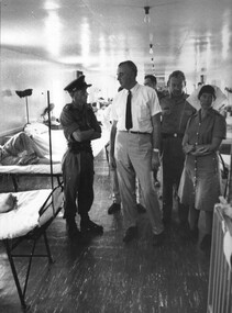
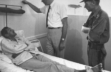
Photograph, Gibbons, Denis, Gough Whitlam 2
Denis Gibbons (1937 – 2011) Trained with the Australian Army, before travelling to Vietnam in January 1966, Denis stayed with the 1st Australian Task Force in Nui Dat working as a photographer. For almost five years Gibbons toured with nine Australian infantry battalions, posting compelling war images from within many combat zones before being flown out in late November 1970 after sustaining injuries. The images held within the National Vietnam Veterans Museum make up the Gibbons Collection.A black and white photograph of the Commanding Officer at the 1st Australian Field Hospital, Vung Tau, South Vietnam, Lt Col Hurley escorts the Leader of the Opposition Mr Gough Whitlam during a visit. photograph, 1st australian field hospital, lt col ray hurley, gough whitlam, vung tau, gibbons collection catalogue, denis gibbons, labour opposition australian government, nurses -
 National Vietnam Veterans Museum (NVVM)
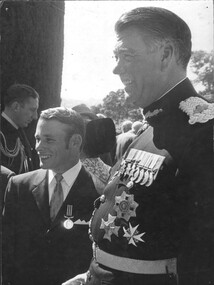
Photograph, Gibbons, Denis, Military Medal
Denis Gibbons (1937 – 2011) Trained with the Australian Army, before travelling to Vietnam in January 1966, Denis stayed with the 1st Australian Task Force in Nui Dat working as a photographer. For almost five years Gibbons toured with nine Australian infantry battalions, posting compelling war images from within many combat zones before being flown out in late November 1970 after sustaining injuries. The images held within the National Vietnam Veterans Museum make up the Gibbons Collection. A black and white photograph of a Medic with the Governor of NSW, Sir Roden Cutler VC after receiving his Military Medal at a cermony Government House NSW in 1971. The award was made for bravery while serving as a medic on a US dustoff helicopter.photograph, 1st australian field hospital, medic, sir roden cutler vc, military medal, dustoff helicopter, gibbons collection catalogue -
 National Vietnam Veterans Museum (NVVM)
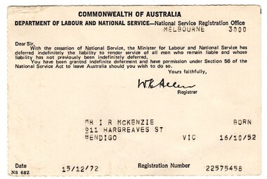
Administrative record - National Services Call Up Card
Standard issue item as used by Australian servicemen during the conflict in Vietnam.Small buff coloured card issued by Commonwealth Govt advising service not required.Commonwealth Governmenti. r. mckenzie, deferrement, vietnam -
 National Vietnam Veterans Museum (NVVM)
Photograph, Gibbons, Denis, Gough Whitlam 1
Denis Gibbons (1937 – 2011) Trained with the Australian Army, before travelling to Vietnam in January 1966, Denis stayed with the 1st Australian Task Force in Nui Dat working as a photographer. For almost five years Gibbons toured with nine Australian infantry battalions, posting compelling war images from within many combat zones before being flown out in late November 1970 after sustaining injuries. The images held within the National Vietnam Veterans Museum make up the Gibbons Collection. A black and white photograph of the Commanding Officer Lt Col Ray Hurley standing by as the leader of the Labour Opposition in the Australian Parliament, Mr Gough Whitlam, talks with a patient at the 1st Australian Field Hospital, Vung Tau, South Vietnam.photograph, 1st australian field hospital, vung tau, lt col ray hurley, gough whitlam, gibbons collection catalogue, denis gibbons, photographer, vietnam war, labour opposition australian government, wounded serviceman -
 Federation University Historical Collection
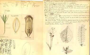
Book - Notebook, Alfred Bock, Notebook of Botanical Lectures by Alfred Ewart, c1891
Alfred James Ewart arrived in Australia from England in 1906. He had extensive knowledge of physiological botany. Ewart held the dual position of Government Botanist and the first Chair of Botany at Melbourne University (and any Australasian University), dividing his time between the National Herberium and the University. Black hard covered exercise book with brown tape spine. Includes handwritten notes, beautiful diagrams, clippings, etc. Contents include: Classification of Systematic Botany, Clissification of fruits, Monocotyledons, Dicityledons, Cannabineae,Quercineae, Ulmaceae, Salicineae, Euphorbiceae, Dialy-petaly, Nymphaeaceae, papaverceae, fumariaceae, Violaceae, Polygalaceae, Hypericineae, Cazyciflora, leguminosae, trifolieae, Umbelliferae, heterosciadieae, haplpzygieae, ericaceae, lentibularinaea, phanerogams .4) Photograph of Melaleuca squarrosa. Wild Flowers of Gippsland, photographed by Alfred Bock, Foster Street, Sale. Inside Front Cover : Anatomy. Histology. Physiology Front Page : A.J. Ewart. Botanical Lectures Advanced 1891-2aj ewart. alfred ewart, ewart, botany, alfred bock, illustration, plants, flora, alfred ewart, alfred james ewart, biodiversity -
Lakes Entrance Historical Society
Book, Department of Territories, Canberra, One People, 1961
Prepared under the authority of the minister for territories, with the co-operation of ministers responsible for Aboriginal welfare in the Australian states, primarily for the celebration of National Aboriginals day in Australia 14th July 1961aboriginals, government -
 Whitehorse Historical Society Inc.
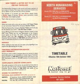
Pamphlet - Bus Timetable, National Bus Company Pty LTD, North Nunawading Bus Services, 10/10/1994
A National Bus Line map and timetable for North Nunawading in 1994 (Routes 270 and 271)A National Bus Line map and timetable for North Nunawading in 1994 (Routes 270 and 271)non-fictionA National Bus Line map and timetable for North Nunawading in 1994 (Routes 270 and 271) -
 Eltham District Historical Society Inc
Photograph - Digital Photograph, Alan King, Alistair Knox Park, Eltham, 2008
Alistair Knox Park, an oasis of peace and beauty. Covered under National Trust of Australia (Victoria) Landscape Significance and Heritage Overlay, Nillumbik Planning Scheme. Published: Nillumbik Now and Then / Marguerite Marshall 2008; photographs Alan King with Marguerite Marshall.; p173 It is hard to imagine that the Alistair Knox Park, an oasis of peace and beauty beside busy Main Road, Eltham, was once the township’s rubbish dump. It was only in the 1970s that the tip was transformed into this beautiful six hectare space, which later earned it a National Trust Landscape classification. Before its life as a dump, the area was used for small farms. Thanks largely to the foresight and efforts of local environmental builder Alistair Knox, the park was designed sympathetically with the character of the wider Eltham landscape. Then, appropriately, the park was named after Knox, who was an Eltham Shire Councillor from 1971 to 1975 and Shire President in 1975. The park designers were four major forces in the urban bush landscape garden –Knox, landscape designer Gordon Ford, artist Peter Glass and landscaper Ivan Stranger. The National Trust citation for the park, originally called Eltham Town Park, includes the Eltham railway trestle bridge and the Shillinglaw Cottage. The citation states ‘the semi-natural setting of the parkland provides a landscape which is evocative of the history of the area’. Manna Gums (Eucalyptus viminalis) and Candlebarks (Eucalyptus rubida) are significant features. Most of the park’s construction was directed by Bob Grant, Superintendent of the Parks and Gardens Department for the Eltham Shire Council. First plantings occurred in Arbour Week in 1973, then the lake and botanic area were completed in 1975, with Federal Government funding, and the toilet block in 1978. Bounded by the Eltham railway line, Panther Place, Main Road, Bridge and Susan Streets, the park is in a valley about a kilometre wide overlooked by steep hills at the east and west. The Diamond Creek flows through it and the picturesque historic timber trestle railway bridge edges the north. Informal plantings of Australian indigenous and native species in open and undulating grassed settings blend with the natural landscape of the Diamond Creek to the west. The bush-style plants, particularly around the creek, balance with open lawns, paths and a cascade flowing from a small lake to another below. A footbridge over the creek leads to the park’s west. The park includes an adventure playground and barbecue areas. The park stands on part of the land bought from the Crown in 1851 by Josiah Holloway, who subdivided it into allotments and which he called Little Eltham. Most of the land was subdivided into residential lots, but the creek valley, on which the park stands, was subdivided into farm-size lots, used mainly for orchards and grazing. One of the earliest owners was John Hicks Petty, who in 1874 bought a plot from Holloway. Other families who owned properties in that area, included Rees, Clark, Waterfall, Graham, Hill and Morant. In 1901 the railway was built through the area. Jock Read, an Eltham resident since around 1920, remembers several farms in the 1920s and ’30s that occupied the site of today’s park. A poultry farm, which extended from present day Panther Place, was owned by the Gahan family. Next to that farm was another for grazing cattle owned by Jack Carrucan. Beside this was land owned by John Lyon. A doctor lived beside this, and at the north-west corner of Bridge Street and Main Road stood a memorial to the soldiers who died in World War One, which was later moved to the RSL site. Mr Read also remembers other farms and orchards west of the creek In the early 1960s the Eltham Council began buying these farms and in the late 1960s turned the areas east of the Diamond Creek into a garbage tip. When this was filled above the creek’s flood plain, the tip was moved to the west of the creek.This collection of almost 130 photos about places and people within the Shire of Nillumbik, an urban and rural municipality in Melbourne's north, contributes to an understanding of the history of the Shire. Published in 2008 immediately prior to the Black Saturday bushfires of February 7, 2009, it documents sites that were impacted, and in some cases destroyed by the fires. It includes photographs taken especially for the publication, creating a unique time capsule representing the Shire in the early 21st century. It remains the most recent comprehenesive publication devoted to the Shire's history connecting local residents to the past. nillumbik now and then (marshall-king) collection, alistair knox park, eltham -
 Bendigo Historical Society Inc.
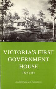
Book - STRAUCH COLLECTION: VICTORIAS FIRST GOVERNMENT HOUSE
A prefabricated, two-bedroom, wooden cottage brought from England by Victoria's first governor, Charles La Trobe. It was erected on his estate "Jolimont" near the current MCG.Booklet, Victoria's First Government House 1839 - 1854 Commentary and Catalogue Fourth edition 1974 National Trust of Australia. Contains black and white photographs and a map.australia, history, government, australia - history - government -
 Falls Creek Historical Society
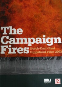
Book - The Campaign Fires - North-East/East Gippsland Fires 2003, Lyndel Hunter
A description of efforts to fight the bushfires in Gippsland in 2003, including maps and illustrations. This volume was published as a tribute to the work of staff and volunteers who put themselves at risk to protect local communities. It shows the impact on those communities in Victoria and the support they gave to those involved in fighting largest bushfires in Victoria for 60 years. The Alpine bushfires started on 8th January 2003, a day of Total Fire Ban. Lightning ignited 87 fires in the North-East and East Gippsland regions. Eight of these fires were unable to be contained; they joined together to form the largest fire in Victoria since the Black Friday fires in 1939. The majority of the area burnt in Victoria was public land, 1.19 million hectares of parks and forests, including 60 per cent of the Alpine National Park and 81 per cent of the Mt Buffalo National Park. Firefighting efforts were made difficult in hard-to-access, remote forest terrain. Approximately 90,000 hectares of private land was burnt.This book is significant because it documents the 2003 Victorian Bushfires and serves as a tribute to the CFA staff and volunteers who fought them.This publication of 119 pages features text, colour images, maps and detailed information related to the 2003 bushfires in Victoria.At bottom of front cover:- CFA Victoria Logo Victorian Government Logovictorian fires 2003, cfa (vic) -
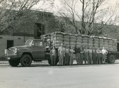 National Wool Museum
Photograph - C. Glover and Sons Pty. Ltd, 1890-1944
C. Glover and Sons Pty. Ltd. was founded on Brougham Street, Geelong c.1870. They operated as a wool and sheepskin storeroom situated on both sides of Brougham Street; where the current Elders building is located. The store was owned and operated by Joshua Glover with his brother Cyrus. A third brother Arthur also worked at the store. It was a very successful business and employed up to 40 men at its peak. Cyrus Glover died quite young, around 54, with his son Howard taking his place in the partnership at 23. During the Second World War the business was requisitioned by the Australian Government. Their wool was utilised to produce defence uniforms for Commonwealth personnel C. Glover and Sons was a very successful business which reluctantly closed its doors around 1975, as a result of the wool industry taking a downward turn Australia wide. It was decided by the family that this was the only option at the time. Howard Glover was Jan Glover’s (donor) father in law. Jan Glover donated these images to the National Wool Museum in 2021. Image 1 is a black and white image of a truck with 11 men standing in front. The truck is loaded with dumped bales of wool. The image is taken outside of the C. Glover and Sons' building. The reverse of the image is stamped. Image 2 is a black and white image of 2 rows of men. The first row of six men are sitting in their cricket whites. The second row of 10 men are standing in suits bar one-man 3rd from the right, who is also in his cricket whites. The image is taken on a cricket oval with the grandstand visible in the background. Image 3 is a black and white image of 12 men. The first 3 men are sitting on wool bales while the other 9 stand behind. The image shows the word 'record' spray painted on a piece of timber hanging behind the man. This is expressed in the men's faces with emotions of joy and celebration coming through. The men are standing in front of large machinery presumed to be used for wool pressing/dumping. Image 4 is a black and white image of 15 men and 5 horses in front of two large white sheds with triangular rooves. The men are all standing with the majority having their arms crossed. On the left is a cart carrying sheep skins. On the right are two smaller carts that appear to be carrying wool bales. Image 5 is a black and white image of a wool and hides storeroom. The ceiling is lined with multiple sheep skins while the floor has multiple wool bales neatly stored. In the background of the image, two men can be seen inspecting wool while sitting at a small white table. Behind this, 5 men are standing in a crowd while another man is seen to the left of the men at the table. This separate man is standing inspecting a wool bale. Image 6 is a black and white image of a wool storeroom. Numerous bales of wool can be seen open for inspection stacked semi-neatly one next to another. 6 men can be seen inspecting a bale of wool in a group. Another 5 men are present in the room performing separate duties.Image 1 Reverse. Black Stamp INTERNATION FOTO-NEWS / H. A SOETEKOUW / 52 GHERINGHAP ST., / GEELONG / PHONE X 2920 Image 2 Wording. Typed black lettering. Geelong Buyers and Brokers Cricket Team. Image 3 Wording. Blue handwriting RECORD OF PRESSING FOR ONE DAY / FORTY BALES / 1910 Image 4 Wording. Blue handwriting. 1890 Image 5 Wording. Typed black lettering. Messrs. Moss & R. Allan. / Government Sheepskin Appraisers. 1918. Image 6 Wording. Black Handwriting. C. GLOVER & SONS. APPRAISEMENT NO. 50 14/12/1944. / GOVERNMENT SHEEPSKIN APPRAISERS. MESSERS. R. BORLAND & H. V. McCALLUM / GEELONG REPRESENTATIVES. J. GLOVER & H. J. GLOVER. c. glover and sons pty. ltd, geelong 1870, brougham street, wool & sheepskin storeroom -
 Wodonga & District Historical Society Inc
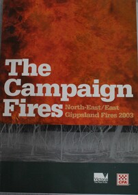
Book - The Campaign Fires - North-East/East Gippsland Fires 2003, Lyndel Hunter, 2003
A description of efforts to fight the bushfires in Gippsland in 2003, including maps and illustrations This volume was published as a tribute to the work of staff and volunteers who put themselves at risk to protect local communities. It shows the impact on those communities in Victoria and the support they gave to those involved in fighting largest bushfires in Victoria for 60 years. The Alpine bushfires started on 8 January 2003, a day of Total Fire Ban. Lightning ignited 87 fires in the North-East and East Gippsland regions. Eight of these fires were unable to be contained; they joined together to form the largest fire in Victoria since the Black Friday fires in 1939. The majority of the area burnt in Victoria was public land, 1.19 million hectares of parks and forests, including 60 per cent of the Alpine National Park and 81 per cent of the Mt Buffalo National Park. Firefighting efforts were made difficult in hard to access, remote forest terrain. Approximately 90,000 hectares of private land was burnt.This publication of 119 pages features text, colour images, maps and detailed information related to the 2003 bushfires in Victoria.non-fictionA description of efforts to fight the bushfires in Gippsland in 2003, including maps and illustrations This volume was published as a tribute to the work of staff and volunteers who put themselves at risk to protect local communities. It shows the impact on those communities in Victoria and the support they gave to those involved in fighting largest bushfires in Victoria for 60 years. The Alpine bushfires started on 8 January 2003, a day of Total Fire Ban. Lightning ignited 87 fires in the North-East and East Gippsland regions. Eight of these fires were unable to be contained; they joined together to form the largest fire in Victoria since the Black Friday fires in 1939. The majority of the area burnt in Victoria was public land, 1.19 million hectares of parks and forests, including 60 per cent of the Alpine National Park and 81 per cent of the Mt Buffalo National Park. Firefighting efforts were made difficult in hard to access, remote forest terrain. Approximately 90,000 hectares of private land was burnt.forest fires -- victoria, bushfires, fires prevention and control -
 Bacchus Marsh & District Historical Society
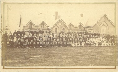
Photograph, Bacchus Marsh State School 1883
Bacchus Marsh State School No. 28. The number of pupils in 1883 was 172. The school has undergone a number of name changes over the years. It began as the Bacchus Marsh National School in 1850 and at the time this photo was taken it was known as Bacchus Marsh State School. Since the 1970s it has been known as Bacchus Marsh Primary. It is officially recognised as the oldest government school in Victoria.This image is important as an early depiction of the first state school in Victoria, and is one of the two earliest images of this school. Small sepia unframed photograph on card with gold border framing photograph. Housed in the album, 'Photographs of Bacchus Marsh and District in 1883 by Stevenson and McNicoll'. Photograph of a six-gabled school building with a large assembly of pupils and teachers in an outdoor setting. There are four adults, probably the teaching staff.On the front: Stevenson & McNicoll. Photo. 108 Elizabeth St. Melbourne. COPIES CAN BE OBTAINED AT ANY TIME. On the back: LIGHT & TRUTH inscribed on a banner surmounted by a representation of the rising sun. Copies of this Portrait can be had at any time by sending the Name and Post Office Money Order or Stamps for the amount of order to STEVENSON & McNICOLL LATE BENSON & STEVENSON, Photographers. 108 Elizabeth Street, MELBOURNE. stevenson and mcnicoll 1883 photographs of bacchus marsh and district, schools, bacchus marsh state school. no. 28. -
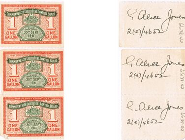 Bendigo Historical Society Inc.
Ephemera - MISS G ALICE JONES COLLECTION: WWII 1 GALLON FUEL RATION TICKETS
Petrol rationing was gazetted in May 1941. Australia's lack of fuel storage options and the diversion of tankers bringing fuel here forced the government to begin rationing. Initially it was proposed that consumption should be reduced by 50% but this was modified to 1/3 reduction. People had to apply for a petrol licence and this was then used to obtain ration coupons. Initially coupons were issued on a 6 monthly basis but this was reduced to 2 monthly and allowed people roughly 2000 gallons per year. Coupons allowed for 1, 2, 5, 10, 44 and 100 gallon amounts depending on need. eg. private, commercial, farm use. Rationing was strictly enforced until 1942 but remained in effect until 1950.WWII 1 Gallon Fuel Ration Tickets: 3 x 1 gallon tickets on cream card with red and green print. Red background of a wall paper of oval shape and Department of Supply and Development. In red print at the top is "Motor Spirit Ration Ticket, issued under National Security (Liquid Fuel) Regulations". 1 One Gallon is in the centre and at the bottom is "This Ticket must be endorsed by consumer with name and licence number". Over printed in green is "Commonwealth Liquid Fuel Control Board, the Commonwealth Emblem and underneath is Valid only until 30th Sept 1941". On the back is "G. Alice Jones 2(e)/4652" on each ticket hand written in black ink.government, federal, fuel ration ticket