Showing 841 items matching "parish plan"
-
 Bendigo Historical Society Inc.
Map - PORTION OF ELMORE ESTATE, 19/10/1920
... and Diggorra, County of Bendigo. Parish plan Canvas backed ( number... and Diggorra, County of Bendigo. Parish plan Canvas backed ( number 143 ...Map: Portion of Elmore Estate, Parishes of Warragamba and Diggorra, County of Bendigo. Parish plan Canvas backed ( number 143 in Map Cupboard 1)map, bendigo, rural, elmore estate , warragamba, diggorra , county of bendigo. -
Bendigo Historical Society Inc.
Map - MAHER'S AND PRETTY'S ESTATE, 8/02/1926
... , County of Rodney. Parish plan Canvas backed. ( number 131... of Rodney. Parish plan Canvas backed. ( number 131 in Map Cupboard 1 ...Map: Maher's and Pretty's Estate, Parish of Toolamba West, County of Rodney. Parish plan Canvas backed. ( number 131 in Map Cupboard 1)map, rodney, rural, maher's , pretty's, toolamba west, county of rodney -
Bendigo Historical Society Inc.
Map - BURNEWANG PARK ESTATE, circa 1920
... , County of Bendigo, Parish Plan ,Canvas backed ( number 127... of Bendigo, Parish Plan ,Canvas backed ( number 127 in Map Cupboard 1 ...Map: Burnewang Park Estate, Parishes of Diggorra and Minto, County of Bendigo, Parish Plan ,Canvas backed ( number 127 in Map Cupboard 1)map, bendigo, rural, burnewang, diggorra, minto, county of bendigo -
Bendigo Historical Society Inc.
Map - KAMAROOKA STATE FOREST, 23/11/1910
... , Parishes of Neilborough and Whirrakee, County of Bendigo. Parish... of Neilborough and Whirrakee, County of Bendigo. Parish plan (number 287 ...Map: Part of Subdivision of kamarooka State Forest, Parishes of Neilborough and Whirrakee, County of Bendigo. Parish plan (number 287 in map cupboard 1)map, bendigo, subdivision, kamarooka state forest, subdivision, whirrakee -
 Bendigo Historical Society Inc.
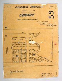
Map - PROPOSED TOWNSHIP PARISH OF CAMPASPE, 24th May 1875
... Map: Proposed Township, Parish of Campaspe(This has been... and 'Creek View' written above). Hand Draughted Parish plan Stapled ...Map: Proposed Township, Parish of Campaspe(This has been crossed out and 'Creek View' written above). Hand Draughted Parish plan Stapled to the backingmap, township, proposed township, campaspe, creek view -
Lakes Entrance Historical Society
Book, Bombala and Districts Historical Society, Backyard History, 1993
... from official records parish plans, and anecdotes, produced... South Wales and district from official records parish plans ...A history of Bombala Shire New South Wales and district from official records parish plans, and anecdotes, produced for research purposes only. Illustrated with maps.settlers, township, genealogy -
Bendigo Historical Society Inc.
Map - BENDIGO SHEET 12, Reproduced 1961
... of Bendigo, Parish plan, Scale 2 chains to 1 inch ( number 142 in Map... of Bendigo, Parish plan, Scale 2 chains to 1 inch ( number 142 in Map ...Map; Bendigo Sheet 12, Parish of Sandhurst , County of Bendigo, Parish plan, Scale 2 chains to 1 inch ( number 142 in Map Cupboard 1)map, bendigo, city streets, bendigo sheet 12, parish of sandhurst , county of bendigo -
Bendigo Historical Society Inc.
Map - BENDIGO SHEET 2, No date visible
... Map: Parish plan showing portion of Bendigo city, West from... Bendigo city streets Bendigo sheet 2 bendigo streets Map: Parish ...Map: Parish plan showing portion of Bendigo city, West from the Echuca rail line, showing lake weeroona ( number 136 in Map Cupboard 1)map, bendigo, city streets, bendigo sheet 2, bendigo streets -
Bendigo Historical Society Inc.
Map - BAMAWM ESTATE, 12/.08/1912
... 1904, County of Bendigo. Parish Plan Canvas backed. ( number... 1904, County of Bendigo. Parish Plan Canvas backed. ( number ...Map: Bamawm Estate, Acquired under Closer settlements Acts 1904, County of Bendigo. Parish Plan Canvas backed. ( number 130 in Map Cupboard 1)map, bendigo, rural, bamawm estate, closer settlement acts 1904, county of bendigo -
Bendigo Historical Society Inc.
Map - BAMAWM ESTATE, 24/02/1931
... 1904, County of Bendigo. Parish plan Canvas backed ( number... 1904, County of Bendigo. Parish plan Canvas backed ( number 129 ...Map: Bamawm Estate, Aquired under closer settlement Act 1904, County of Bendigo. Parish plan Canvas backed ( number 129 in Map Cupboard 1)map, bendigo, rural, bamawm estate, closer settlement acts 1904, county of bendigo -
 Bacchus Marsh & District Historical Society
Map, Bacchus Marsh Region Parish Plans: Folded set of maps
... Set of Victorian Lands Department Parish Plans covering... Interim Record Set of Victorian Lands Department Parish Plans ...Set of Victorian Lands Department Parish Plans covering the township of Bacchus Marsh and surrounding districts. Folded. BMDHS Location: AR/SU27/D2: Map Drawersmaps bacchus marsh region, bacchus marsh victoria maps, interim record -
 Bendigo Historical Society Inc.
Map - BENDIGO (PART), No date visible
... of High St. between Ophir St. and View Place. Parish plan. Older... side of High St. between Ophir St. and View Place. Parish plan ...Map:Part of Sandhurst City streets, showing west side of High St. between Ophir St. and View Place. Parish plan. Older unidentifiable map on the reverse side.map, bendigo, city streets, bendigo city streets, sandhurst city streets -
Bendigo Historical Society Inc.
Map - LEICHARDT, 23/05/1875
... Map: Parish of Leichardt, County of Bendigo. Parish plan... of Bendigo. Parish plan (coloured). Attached plan in the top left ...Map: Parish of Leichardt, County of Bendigo. Parish plan (coloured). Attached plan in the top left hand corner marked 'Building Lots' (number 323 in map cupboard 1)map, bendigo, building lots, leichardt -
 Bendigo Historical Society Inc.
Map - JACK FLYNN COLLECTION: HUNTLY, 12.03.1932
... of Bendigo. Parish plan. Western and South Riding Division on Main St...: Township of Huntly, Parish of Huntly , County of Bendigo. Parish ...Map: Township of Huntly, Parish of Huntly , County of Bendigo. Parish plan. Western and South Riding Division on Main St. (Main Northern Highway) - written in ink below name of map.BY Authority H.J. Green. Photo-Lithographed at the Dept., of Lands and Survey, Melbourne. 12.3.32map, bendigo, township, huntly -
Bendigo Historical Society Inc.
Map - SUBDIVISION OF STERNBERG'S ESTATE, 24/06/1920
... of Bendigo. Parish plan Canvas backed ( number 133 in Map Cupboard... of Rochester West, County of Bendigo. Parish plan Canvas backed ...Map: Subdivision of Sternberg's Estate, Crown Allotments 75, 76, 76A, 76B and 77, Parish of Rochester West, County of Bendigo. Parish plan Canvas backed ( number 133 in Map Cupboard 1)map, bendigo, rural, sternberg's, crown allotments 75, 76, 76a, 76b, 77, rochester west, county of bendigo -
Bendigo Historical Society Inc.
Map - CAMPBELL COLLECTION: BENDIGO & DISTRICT MAPS, 14-6-29
... Assessment Plan and Parish Plans. H.A. Darby. (number 378 in map.... Prepared in W.P.B. from Assessment Plan and Parish Plans. H.A ...Map. Eppalock, Sedgwick and Strathfieldsaye. Scale 20 chains to 1 inch. Total area 3972 acres. Prepared in W.P.B. from Assessment Plan and Parish Plans. H.A. Darby. (number 378 in map cupboard 1)H.A.Darbymap, bendigo, agricultural lands -
 Bacchus Marsh & District Historical Society
Map, Gorrockburkchap Parish Map, County of Grant c.1915
... A single page paper map showing the parish plan... A single page paper map showing the parish plan for Gorrockburkchap ...The parish of Gorrockburkchap (sometimes spelled Gorrockburkghap) lies to the west and south west of the township of Bacchus Marsh. The locality of Rowsley is situated within this parish area.A single page paper map showing the parish plan for Gorrockburkchap in the County of Grant. The map is pasted into a bound volume containing 76 maps or plans in total. High resolution digital image stored on BMDHS computer network. gorrockburkchap parish maps, rowsley victoria maps -
 Bacchus Marsh & District Historical Society
Map, Gorrockburkchap Parish Map, County of Grant
... A single page paper map showing the parish plan... A single page paper map showing the parish plan for Gorrockburkchap ...The parish of Gorrockburkchap (sometimes spelled Gorrockburkghap) lies to the west and south west of the township of Bacchus Marsh. The locality of Rowsley is situated within this parish area.A single page paper map showing the parish plan for Gorrockburkchap in the County of Grant. The map is pasted into a bound volume containing 76 maps or plans in total. High resolution digital image stored on BMDHS computer network. gorrockburkchap parish maps, rowsley victoria maps -
Bendigo Historical Society Inc.
Map - CAMPBELL COLLECTION: BENDIGO & DISTRICT MAPS, 22-3 29
... Map. Marong, Parishes of Marong, Lockwood and Mandurang... Bendigo allotments G.W.L Map. Marong, Parishes of Marong, Lockwood ...Map. Marong, Parishes of Marong, Lockwood and Mandurang. Scale 20 chains to an inch. Total area 5106 acres. Crusoe Reservoir on right. Compiled in W.P.B. from Field Survey and Parish Plans (number 373 in map cupboard 1)G.W.Lmap, bendigo, allotments -
 Bendigo Historical Society Inc.
Photograph - WES HARRY COLLECTION: TOWNSHIP OF SANDHURST, 1854
... Photograph of the Parish Plan of the Township of Sandhurst... Photograph of the Parish Plan of the Township of Sandhurst in 1854 ...Photograph of the Parish Plan of the Township of Sandhurst in 1854. It covers the area of the CBD from Mitchell (not named) to Bernal Streets and from the Bendigo Creek to Mollison St. ( other than Pall Mall and McRae streets, none of these parallel streets are named)place, bendigo, first survey, sandhurst, first survey, bendigo creek -
 Eltham District Historical Society Inc
Slide - Photograph, Eltham Shire Council, Plan of Subdivision, Crown Allotment 8, Section 8A, Parish of Nillumbik,County of Evelyn, 1969
... melbourne Carter Infrastructure Map North Warrandyte Pain Parish ...35mm colour positive transparency blue Agfacolour Service plastic mountC1, Pain, Sibbel and Carter, Research-Warrandyte Road, North Warrandyte, 4 August 1969carter, infrastructure, map, north warrandyte, pain, parish of nillumbik, plan of subdivision, planning, research-warrandyte road, sibbel, subdivison lots -
Bendigo Historical Society Inc.
Map - CAMPBELL COLLECTION: BENDIGO AND DISTRICT MAPS, 14-6-29
... Assessment and Parish Plans by W.J.G. 14-6-29. (number 388 in map... acres, prepared in W.P.B. from Assessment and Parish Plans ...Map. Terricks, Parish of Terrick Terrick West, scale 20 chains to 1 inch, total area 6318 acres, prepared in W.P.B. from Assessment and Parish Plans by W.J.G. 14-6-29. (number 388 in map cupboard 1)W.J.Galbraithmap, bendigo, agricultural lands -
Bendigo Historical Society Inc.
Map - CAMPBELL COLLECTION: BENDIGO AND DISTRICT MAPS, 18-6 29
... Plan and Parish Plan by H.A. Darby18-6-29., Wondong, Heathcote... acres. Prepared from Assessment Plan and Parish Plan by H.A ...Map. Longlea, Parishes of Axedale and Eppalock, scale 20 chains to 1 inch, total area 2372 acres. Prepared from Assessment Plan and Parish Plan by H.A. Darby18-6-29., Wondong, Heathcote and Sandhurst line (Railway). (number 386 in map cupboard 1)H.A.Darbymap, bendigo, agricultural lands -
 Bacchus Marsh & District Historical Society
Map, Gorrockburkchap Parish Map, County of Grant c.1906
... A single page paper map showing the parish plan... Bacchus Marsh Region Parish Plans A single page paper map showing ...The parish of Gorrockburkchap (sometimes spelled Gorrockburkghap) lies to the west and south west of the township of Bacchus Marsh. The locality of Rowsley is situated within this parish area.A single page paper map showing the parish plan for Gorrockburkchap in the County of Grant. A cadastral map showing parish boundaries and land ownership The map is pasted into a bound volume containing 76 maps or plans in total. High resolution digital image stored on BMDHS computer network. gorrockburkchap parish maps, rowsley victoria maps, bacchus marsh region parish plans -
Bendigo Historical Society Inc.
Map - CAMPBELL COLLECTION: BENDIGO AND DISTRICT MAPS
... . from Assessor's plan and Parish Plan. (number 350 in map... in W.P.B. from Assessor's plan and Parish Plan. (number 350 in map ...Map. Whirrakee, Parish of Whirrakee. Total area of map 4419 acres. Scale 20 chains to 1 inch. 23 allotments are sold, Eucalypt oil distillery on lower portion of map. Prepared in W.P.B. from Assessor's plan and Parish Plan. (number 350 in map cupboard 1)map, bendigo, allotments -
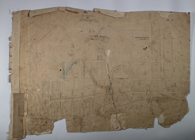
 Federation University Historical Collection
Plan, Department of Crown Lands and Survey, Melbourne, Buninyong County of Grant, 23/07/1929
... A parish plan of Buninyong, including Robert Scott's Mt... Recreation Reserve A parish plan of Buninyong, including Robert ...The plan was photo-lithographed at the Departmen tof Lands and Survey, MelbourneA parish plan of Buninyong, including Robert Scott's Mt Buninyong Pre-emptive Right, Mt Buninyong Public Park, Thomas Learmonth's land, John Learmonth's land, Scotchan's, Yendon. The Buninyong POst Office is Allotment 1. Pisition of tracks in 1859 have been marked on the plan in red.buninyong, scotchman's, mt buninyong, robert scott, clarendon, lal lal creek, yendon, warrenheip, yarowee, enfield, thomas learmonth, john learmonth, archibald fisken, g. schloo, george innes, peter inglis, durham lead, j. fry, j. forrest, parkin lee, buninyong recreation reserve -
Bendigo Historical Society Inc.
Map - CAMPBELL COLLECTION: BENDIGO AND DISTRICT MAPS, 22-3-29
... Survey and Parish Plans. B.W.L.22-3-29 (number 389 in map... in W.P.B. fro Field Survey and Parish Plans. B.W.L.22-3-29 (number ...Map. Marong, Parishes of Marong, Lockwood and Mandurang, Scale 20 chains to 1 inch, Total area 5106 acres. Crusoe Reservoir & Viaduct and water race. Compiled in W.P.B. fro Field Survey and Parish Plans. B.W.L.22-3-29 (number 389 in map cupboard 1)B.W.L.map, bendigo, allotments -
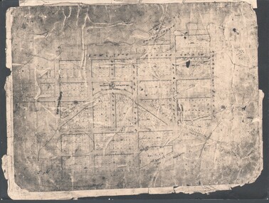
 Federation University Historical Collection
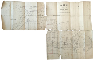
Plan, Haddon, County of Grenville, 1932, 13/04/1932
... The Haddon Parish Plan shows crown parcels government roads... collard smith james roach j. mitchell The Haddon Parish Plan shows ...The Haddon Parish Plan shows crown parcels government roads, Crown Reserves, Railway. Scale 40 chains to 1" (1:31, 680) WGS 84 Centroid Lat: 37 degrees 34' 00" S Long: 148 degrees 40' 20" E N.S. 9.3km E.W.: 16.1kmhaddon, grenville, cardigan, water supply reserve, nentingbook pre-emptive right, a. mclachlan, lake burrumbeet, e.a. wynne, p. russell, b. hepburn, benjamin hepburn, nentingbool, t.c. wilson, j. amoy, william collard smith, james roach, j. mitchell -
 Bacchus Marsh & District Historical Society
Map, Balliang Parish Map, County of Grant c.1907
... A single page paper map showing parish plan map... paper map showing parish plan map for Balliang. This parish area ...A single page paper map showing parish plan map for Balliang. This parish area contains the localities of Balliang and Balliang East and is located south of the township of Bacchus Marsh. The map is pasted into a bound volume containing 76 maps or plans in total. High resolution digital image stored on BMDHS computer network. balliang victoria maps, balliang parish maps -
 Federation University Historical Collection
Plan, Haddon County of Grenville, 1887, 1887
... Parish Plan of Haddon showing the township of Haddon.... Cunningham Applic' Parish Plan of Haddon showing the township ...Parish Plan of Haddon showing the township of Haddon, Cardigan and Haddon State Forest, Lake Burrumbeet and Nentingbook Pre-emptive Right. Names on the allotments include H. Cuthbert, B. Hepburn, T.W. Lloyd, J. Palmer, E.A. Wynne, William Collard Smith, A. Porteous, P. Russell, J. Mitchell, G. Renniehandwritten 'J. H. Cunningham Applic'haddon, cardigan, haddon state forest, lake burrumbeet, nentingbook pre-emptive right, h. cuthbert, b. hepburn, t.w. lloyd, j. palmer, e.a. wynne, william collard smith, a. porteous, p. russell, j. mitchell, g. rennie, j. noone, department of lands and survey