Showing 25583 items matching "plenty-township-estate"
-
 Greensborough Historical Society
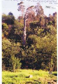
Photograph - Photograph (Copy), Anne Paul, Squizzy Taylor's target tree, taken from old road in front of Plenty Bridge Hotel, Lower Plenty 2003, 2003_05
Squizzy Taylor's target tree, taken from old road in front of Plenty Bridge Hotel, Lower Plenty 2003. It is believed that Squizzy Taylor hid at the Plenty Bridge Hotel and used this tree for target practice.2 colour photographs printed on paper, handwritten captionslower plenty, plenty river, squizzy taylor, plenty bridge hotel -
 Greensborough Historical Society
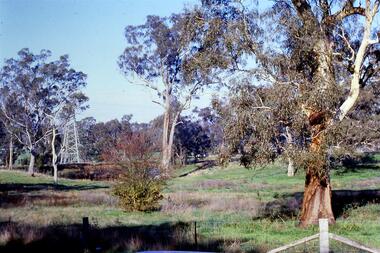
Slide - Photograph, John Ramsdale, Near the confluence of the Plenty and Yarra Rivers, Lower Plenty: Slide 118, 1990s
Photograph shows a rural scene with gumtrees and pylon. This is near the confluence of the Plenty and Yarra Rivers, Lower PlentyPart of the John Ramsdale collection of slides and audio visual material.Colour photograph scanned from slide.No maker's marks. No caption on slide.yarra river, plenty river, lower plenty -
 Rutherglen Historical Society
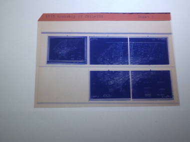
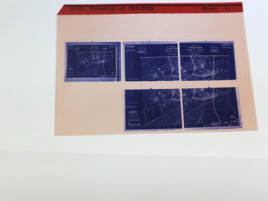
Microfiche of 5 Aperture Card sized microfilm, Victorian Land Tiltes Office, Township of Chiltern
Township layout of Chilterncard with a single microfilm insertplan, town, boundries, lots, roads -
 Rutherglen Historical Society
Microfiche of 5 Aperture Card sized microfilm, Victorian Land Tiltes Office, Township of Chiltern
Township layout of Chilterncard with a single microfilm insertplan, town, boundries, lots, roads -
 Rutherglen Historical Society
Microfiche of 5 Aperture Card sized microfilm, Victorian Land Tiltes Office, Township of Chiltern
Township layout of Chilterncard with a single microfilm insertplan, town, boundries, lots, roads -
 Rutherglen Historical Society
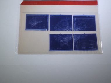
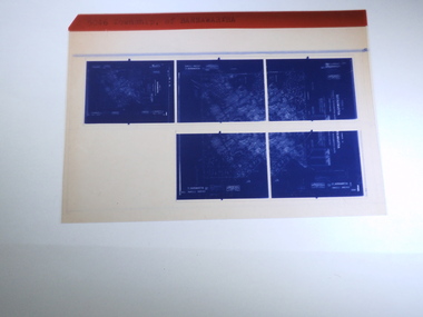
Microfiche of 5 Aperture Card sized microfilm, Victorian Land Tiltes Office, Township of Barnawartha
Township layout of Barnawarthacard with a single microfilm insertplan, town, boundries, lots, roads -
 Ringwood and District Historical Society
Letter, Property for sale - Ringwood Shop and Dwelling Estate, Ringwood, Victoria - circa 1925
ID 5225 note: Further information relating to allotments marked on the hand-drawn plan are included in ID 5224 - Ringwood Station Estate.Typewritten letter from A.V. Greenwood with hand drawn plan of Ringwood Shop and Dwelling Estate, detailed description of property for sale, and top and side elevation views of house. (7 pages)(Transcript of first page - to unknown recipient) Phone 988 Central, 331 Canty Greenwood Pty. Ltd. 5 Flinders Street Melbourne. Dear Sir, 1. Attached please find drawings of my house at Ringwood. 2. It is for sale at £4,865 or to let at £5 per week to an approved tenant. 3. I sold it to Mr. De Garis and vacated it, but it is now back on my hands. 4. I leased another place instead of living in my own. I may be able to cancel same; in the meantime, however, I propose to sell or let my own. The painters are now going through the place; re-varnishing, re-oiling and re-polishing so that in about five days it will look "spick and span". 5. The house was specially built under my own supervision. 6. It is very suitable for a high class Guest House, Doctor's residence, Hospital or Convalescent Home. If you know of anyone whom it might suit, please communicate with them. DESCRIPTION 7. It stands on 305 feet of land facing Greenwood Avenue. It is cement, roughcast and hardwood, well oiled, and is now being redone so that the house is as good as new; red tile roof; verandahs three sides; two sleep-outs; five bedrooms; large dining room; very large music room with nooks, upstairs lounge, study; sewing room; built-in wardrobes and cupboards throughout; handsome kitchen with handsome pantry cupboard with drawers and glass front; one bath room; one shower room; wash house with patent copper and laundry. Every modern convenience, hot water system (through copper pipes with large copper cylinder) electric lights everywhere, outside and in, Yan Yean water laid on everwhere throughout house and gardens. Floors throughout are the very best, close set, stained and polished; dainty lead light windows etc. 8. There is a big garage, with tiled roof and two rooms with all conveniences for a married couple. Property is well drained with a system of its own. The house stands upon the top of a hill close to Railway Station, say 500 feet from the Footbridge. 9. The garden has expansive shrubs; sheds; fernery; tennis court. 10. A handsome piece of furniture goes with the house; a combination pantry and storeroom for groceries, milk, bread etc., consisting of drawers, glass and wire doors, as mentioned above. 11. It is within easy distance of Melbourne as it is only two minutes from Ringwood Station, which is a frequent electric train service bringing it within 39 minutes of the City. It is thought better by some to go further out into the country atmosphere and walk a short distance at the end than to go by train 20 minutes then walk 15 to 20 minutes. 12. The price quoted of £4,865 is made up as follows - 305 feet of land @ £5 ... £1,515 Garage and dwelling ... £300 House hot water system, American cupboard ... £2,600 Water, fencing, sheds & drain ... £250 For the lot ... £4,865 Should you require copies of the enclosed drawings I shall be pleased to supply same. 13. Mr. J.B. McAlpin is the local agent, Phone Ring. 7 (after hours Ring. 44) or you may phone me Central 988. 14. The house is south of the line, facing Greenwood Avenue and immediately at the back of Ringwood House, which is also my property. Yours sincerely, A.V. Greenwood (illegible) ..... (Transcript of second page) RINGWOOD SHOP AND DWELLING ESTATE See these letters on plan attached (H.) Ringwood House and Shops on 100 by 150 feet of land fronting Bedford Road 100 feet @ £10 per foot - £1,000 House and shops - £2,400 ... £3,400 Ringwood House consists of Boarding House, (Phone 101) and two shops, mainly brick; 9 inch walls. Will carry another story. Has music room, dining room, entrance halls, 10 bedrooms, large verandahs, all conveniences, hot and cold water, and stands on what will become a most valuable business corner. (F.)(G.) Mr. Greenwood's house, garage and sheds, stands on 307 feet of land fronting Greenwood Avenue. See detailed description attached ... £4,865 (J.) Cottage on Block 81 in William Street ... £750 (K.) Cottage in Pitt Street ... £650 (Total) £9,665 ..... (Description of third page - Subdivision Plan) Drawn by Edyth Greenwood, phone 988 Central. Subdivision includes Station Street, Pitt Street, Bedford Road, Wantirna Road, James Street, William Street (later Kendall Street), Greenwood Avenue, Ellison Street, and Haig Street. Circles denote blocks for sale. Squares denote house properties for sale. Other features marked include location of businesses along Main Street (Maroondah Highway), cool store, railway station, shop and police station on Bedford Road, church on Station Street, site of schoolmaster's residence and State School, and location of proposed public baths -
 Ringwood and District Historical Society
Plan, Ringwood Station Estate, Subdivision, Ringwood, Victoria - circa 1925
ID 5224 note: Further information relating to squares marked H, F, G, J, and K included in ID 5225 - Ringwood Shop and Dwelling Estate.Hand drawn plan of Ringwood Station Estate showing allotments for sale, with two typed pages attached showing land title information and sale prices.Drawn by Edyth Greenwood, phone 988 Central. Subdivision includes Station Street, Pitt Street, Bedford Road, Wantirna Road, James Street, William Street (later Kendall Street), Greenwood Avenue, Ellison Street, and Haig Street. Circles denote blocks for sale. Squares denote house properties for sale. Other features marked include location of businesses along Main Street (Maroondah Highway), cool store, railway station, shop and police station on Bedford Road, church on Station Street, site of schoolmaster's residence and State School, and location of proposed public baths. Ryner & Langford, Solicitors -
 Kew Historical Society Inc
Plan - Subdivision Plan, J R Mathers & McMillan, Myrtle Hill Estate, East Kew, circa 1949, c.1949
The Kew Historical Society's map collection includes a substantial number of real estate subdivision plans, mainly of Kew but also of surrounding suburbs in Melbourne. Most of the subdivision plans date from the 1920s and 1930s when the districts old homes and local farmland were being split up to accommodate residential growth in the postwar period. These early plans were assembled by a local firm, Jas R Mather & McMillan, which had an office in Cotham Road. Many of the plans, and sometimes photos, were annotated by the agents.Subdivision plans are historically important documents used as evidence for the growth of suburbs in Australia. They frequently provide information about when the land was sold as well as evidence relating to surveyors and real estate and financial agents. The numerous subdivision plans in the Kew Historical Society's collection represent working documents, ranging from the initial sketches made in planning a subdivision to printed plans on which auctioneers or agents listed the prices for which individual lots were sold. In a number of cases, the reverse of a subdivision plan in the collection includes a photograph of a house that was also for sale by the agent. These photographs provide significant heritage information relating house design and decoration, fencing and household gardens.The photograph may also be aesthetically significant depending on the importance of the photographic atelier.Myrtle Hill, at 14 Vista Avenue, Kew, is of local historical and architectural significance as a good example of a large and imposing single-storey Italianate house of the early 1870s surviving in Kew. Originally sited on a large allotment overlooking Normanby Road, the setting of the house has been dramatically altered through extensive subdivision and development. The subdivision plan of the ‘Myrtle Hill Estate’ indicates that in one such subdivision, 11 allotments were created fronting Bowyer Avenue, Myrtle Avenue, and Normanby Road. The outline and building profile of Myrtle Hill is shown on the west side of Bowyer Avenue.The full (typed) title of this subdivision plan is :"Plan of SUBDIVISION of part of CROWN PORTION 83. / at KEW / PARISH OF BOROONDARA. / COUNTY OF BOURKE". / "MYRTLE HILL ESTATE / EAST KEW" In addition to the Title and subtitle, the plan also lists the advantages of the subdivision. -
 Eltham District Historical Society Inc
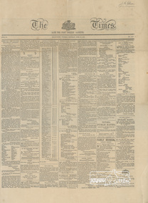
Newspaper clipping, Advertisement: New Township of Little Eltham, The Times, Late The Port Phillip Gazette, 12 April 1851, p1
Establishment of the township of Little ElthamLaminated front page and p2 (facsimile?)j.m. holloway, little eltham -
 Stawell Historical Society Inc
Document - Realia, Certificate of Title Extract - Heatherlie Quarry Township
Heatherlie Quarry Township TitleCertificate of Title - A 3 Laminatedextract from Concongella Register book Vol 9806. Folio 608heatherlie quarry -
 Mt Dandenong & District Historical Society Inc.
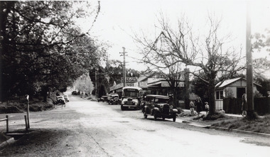
Photograph, Olinda Township c1950, c1950
Scene in Olinda township looking up towards range Road. Cars and busses parked along roadside and women and children on footpath. General Store and Gills Newsagency on LHS. c1950.olinda, gills newsagency -
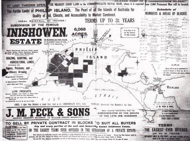 Phillip Island and District Historical Society Inc.
Map & Newspaper clipping, The Argus, Inishowen Estate, c1910 and 3/11/1868
Selection of land on Phillip island. Early subdivision of "Inishowen" Estate.449-01: Map of Phillip island showing "Inishowen" Estate c 1910 449-02: Newspaper article on the selection of land plus listing of people who obtained land. Argus 03/11/1868.inishowen estate phillip island, phillip island land selection 1868 -
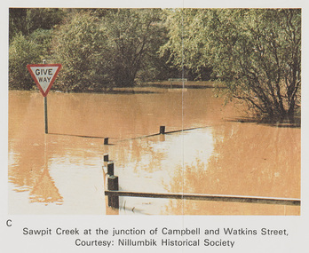 Eltham District Historical Society Inc
Work on paper (Sub-Item) - Photograph, Sawpit Creek at the junction of Campbell and Watkins Street, Diamond Creek Township, 8 April 1977
Colour photograph. Sawpit Creek at the junction of Campbell and Watkins Street, Diamond Creek Township. The Diamond Creek in flood at Diamond Creek township, 8 April 1977 Nillumbik Historical Society collectionflood, diamond creek, flooding, nillumbik historical society, give way, sawpit creek, campbell street, watkins street -
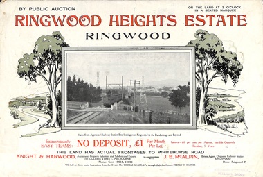 Ringwood and District Historical Society
Flyer, Subdivision Advertisement - Ringwood Heights Estate Public Auction - March, 1924
Refer also to Reg. No. 5185 for Ringwood Heights Estate final section release (August 1924)Folded double-sided brochure advertising Ringwood Heights Estate Public Auction on Saturday March 1, 1924, with town photographs, location map, terms of sale, and summary of local features and services.Subdivision includes Whitehorse Road, Bon View Avenue, Grant Crescent, Hillcrest Avenue, Heatherbrae Avenue, Margaret Street, and Mary Street. (Agents) Knight & Harwood, 315 Collins Street, Melbourne, Phones Central 10615, 10616, in conjunction with J.B. McAlpin, Opposite Railway Station, Ringwood, Phone Ringwood 7. -
 Kew Historical Society Inc
Plan - Subdivision Plan, Jas R Mathers Son & McMillan, Eastlawn Estate : East Kew Auction Sale, 1914
The Kew Historical Society's map collection includes a substantial number of real estate subdivision plans, mainly of Kew but also of surrounding suburbs in Melbourne. Most of the subdivision plans date from the 1920s and 1930s when the districts old homes and local farmland were being split up to accommodate residential growth in the postwar period. These early plans were assembled by a local firm, Jas R Mather & McMillan, which had an office in Cotham Road. Many of the plans, and sometimes photos, were annotated by the agents.Subdivision plans are historically important documents used as evidence for the growth of suburbs in Australia. They frequently provide information about when the land was sold as well as evidence relating to surveyors and real estate and financial agents. The numerous subdivision plans in the Kew Historical Society's collection represent working documents, ranging from the initial sketches made in planning a subdivision to printed plans on which auctioneers or agents listed the prices for which individual lots were sold. In a number of cases, the reverse of a subdivision plan in the collection includes a photograph of a house that was also for sale by the agent. These photographs provide significant heritage information relating house design and decoration, fencing and household gardens.The photograph may also be aesthetically significant depending on the importance of the photographic atelier.The ‘Eastlawn Estate’ was surveyed and ready for auction in March 1914, three months before the outbreak of World War I. Sixty-six allotments, created on the ‘order of Mr & Miss Preston’ surrounded the mansion of Woodlands in Harp Road. Woodlands formed part of the Estate, being advertised as lot 1. The allotments faced High, Station and Wright Streets, Harp and Normanby Roads, and Woodlands Avenue. Pru Sanderson in the Kew Conservation Study (Vol.2, 1988) wrote that the Eastlawn Estate ‘covered the western half of the failed Harp of Erin Estate’. Contemporary advertisements promoted the Eastlawn Estate as: ‘There will be no more convenient district nor pleasant Suburb than East Kew for the busy business man. When the Electric Tram is laid, he will be able to journey quickly and pleasantly direct from Collins Street to his home in the Eastlawn Estate in about 20 minutes’. The actual plans of subdivision were included in advertisements in The Argus and in the local newspapers."C" top left. Various annotations.subdivision plans - kew, station street, normanby road, high street, woodlands avenue, harp road, woodlands - kew -
 Greensborough Historical Society
Photograph - Photograph (Copy), Anne Paul, Old Plenty Bridge Lower Plenty, 2003_05
Various views of entry into Lot 2A Main Road Lower Plenty, now Edward Willis Drive, including the old Plenty River Bridge.3 colour photographs printed on paper, handwritten or typed captionslower plenty, main road lower plenty, edward willis drive lower plenty, plenty river bridge, plenty river forum -
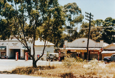 Eltham District Historical Society Inc
Photograph, Lower Plenty shops and garage
Colour photograph of old shops and service station Lower Plenty (prior to construction of present shopping centre). 4 x 6 print and 8 x 10 laminated printshops, service station, lower plenty, main road -
Port Melbourne Historical & Preservation Society
Plan, Department of Lands and Survey, The Township of Sandridge, 25 Nov 1860
Plan of the township of Sandridge lithographed at the department of Lands and Survey, Melbourne 5th November, 1860. Identical to 1859 version except for added rail line through Sandridge and onto Town Pierengineering - roads streets lanes and footpaths, municipal district of sandridge -
Tatura Irrigation & Wartime Camps Museum
Poster, Subdivision of Township Allotments
Poster depicting the land which was being sold by J S Darby on the 3 December 1890. Auctioneer was Martin Cussen and Co. Map shows location of land.Single sheet of paper, laminated. Advertising land subdivision for sale in the township of Rushworth. Being sold by Martin Cussen and Co, auctioneers for J S Darby. Shows map of land subdivision.rushworth, land subdivision, martin cussen and co, j s darby -
Whitehorse Historical Society Inc.
Newspaper - Article, Estate notice for estate of Harold Exton Turner, 5/02/1992
Law notice from The Age 5 Feb 1992 on the estate of Commander Harold Exton Turner.turner, harold exton, cmdr., endeavour street, mitcham, no 16 -
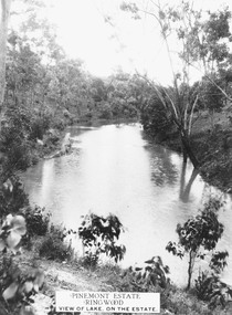 Ringwood and District Historical Society
Photograph, Pinemont Estate, Ringwood. View of lake
Label on photograph reads, "Pinemont Estate, Ringwood. View of lake, on the estate". (2 copies) -
 Ringwood and District Historical Society
Flyer, Subdivisional Land Auction Sale Brochure, Grand Central Estate, Ringwood, Vic. - 1925
Douglas Street shown in the estate plan did not eventuate, but was developed as a public reserve. Refer also to Reg. No. 5149 for 1924 auction sale of land also titled Grand View Estate situated further north in Ringwood.Double sided multi-folded page advertising public auction sale on Saturday, 31st October, 1925, of residential allotments highlighting local facilities, services and layout of the estate. Includes panoramic view of Ringwood and other local photographic images.Subdivision includes Great Ryrie Street, Heathmont Road, Douglas Street, Garden Street, and Bellevue Avenue. Agents - Knight & Harwood, 315 Collins Street, Melbourne, Phone 10615, 10616 Central, in conjunction with J.B. McAlpin, Opposite Railway Station, Ringwood. Phone Ringwood 7. -
 Eltham District Historical Society Inc
Audio - Audio Compact Disc, Audio Recording; Victoria's Anzac Centenary: Anzac Stories produced by Bill McGillivray, recorded by 88.6 Plenty Valley FM, 24 March-24 April 2016, 2016
Two Compact Discs produced by 88.6 Plenty Valley FM Disc 1 Tracks 01 Introduction; MP3 file, 01.02MB; 0.44 02 Epping District (written and spoken by Felicity Williams, Head of English, Mill Park Secondary College); MP3 file, 9.94MB; 07:14 03 P. E. Cook (wriiten and spoken by Liz Pidgeon, Local and Family History Librarian, Yarra Plenty Regional Library); MP3 file, 10.5MB; 07:38 04 Research Honour Board (wriiten by Jim Allen of Eltham District Historical Society and spoken by Daniel Polombi of Plenty Valley FM; MP3 file, 7.52MB; 05:28 05 Will Longstaff (wriiten by Bill McGililvray, Plenty Valley FM and spoken by Daniel Polombi of Plenty Valley FM; MP3 file, 9.01MB; 06:33 06 Robert Smith (wriiten and edited by Bill McGillivray, Plenty Valley FM and spoken by Shelley Carpatharcus and Daniel Polombi of Plenty Valley FM; MP3 file, 9.55MB; 06:57 07 Stanley Addison (wriiten and spoken by Jim Connor of Eltham District Historical Society; MP3 file, 9.25B; 06:43 08 Bessie Gallagher (wriiten by Maureen Jones and and spoken by Geraldine Ishken of Plenty Valley FM; MP3 file, 12.3MB; 08:58 Disc 2 Tracks 09 George Muir Letter 1 (wriiten by Maureen Jones and and spoken by Geraldine Ishken of Plenty Valley FM; MP3 file, 9.32MB; 06:47 10 George Muir Letter 1 Part 2; MP3 file, 9.17MB; 06:40 11 George Muir Letter 1 Part 3; MP3 file, 8.50MB; 06:11 12 George Muir Letter 2; MP3 file, 4.91MB; 03:34 13 George Muir Letter 3; MP3 file, 7.25MB; 05:17 14 George Muir Letter 4; MP3 file, 5.59MB; 04:04 15 George Muir Letter 5; MP3 file, 4.63MB; 03:22 16 George Muir Letter 6; MP3 file, 3.38MB; 02:27 17 George Muir Letter 7 (introduction by Jim Connor of Eltham District Historical Society, original letters by George Muir, commentary written by Helen Mann and Bill McGillivray of Plenty Valley FM, spoken by Romero Callaghan and Stephen Pidgeon); MP3 file, 4.36MB; 03:10 18 George Muir Letter (introduction by Jim Connor of Eltham District Historical Society, original letters by George Muir, commentary written by Helen Mann and Bill McGillivray of Plenty Valley FM, spoken by Craig Wright of Planty Valley FM); MP3 file, 12.4MB; 09:02alan marshall, anzac stories, audio cassette, audio recording, bessie gallagher, bill mcgillivray, community radio, craig wright, daniel polombi, eltham district historical society, epping district, felicity williams, george muir, geraldine ishken, helen mann, jim allen, jim connor, liz pidgeon, maureen jones, mill park secondary college, p.e. cook, plenty valley 88.6 fm, research honour board, robert smith, romero callaghan, shelley carpatharcus, stanley simpson addison, stephen pidgeon, victoria's anzac centenary, will longstaff, yarra plenty regional library -
 Kew Historical Society Inc
Map - Subdivision Plan, Grenville Estate, 1922
Pru Sanderson, in her groundbreaking ‘City of Kew Urban Conservation Study : Volume 2 - Development History’ (1988), summarised the periods of urban development and subdivisions of land in Kew. The periods that she identified included 1845-1880, 1880-1893, 1893-1921, 1921-1933, 1933-1943, and Post-War Development. These periods were selected as they represented periods of rapid growth or decline in urban development. An obvious starting point for Sanderson’s groupings involved population growth and the associated economic cycles. These cycles also highlighted urban expansion onto land that was predominantly rural, although in other cases it represented the decline and breakup of large estates. A number of the plans in the Kew Historical Society’s collection can also be found in other collections, such as those of the State Library of Victoria and the Boroondara Library Service. A number are however unique to the collection.Subdivision plans are historically important documents used as evidence of the growth of suburbs in Australia. They frequently provide information about when the land was sold on which a built structure was subsequently constructed as well as evidence relating to surveyors and real estate and financial agents. The numerous subdivision plans in the Kew Historical Society's collection represent working documents, ranging from the initial sketches made in planning a subdivision to printed plans on which auctioneers or agents listed the prices for which individual lots were sold. In a number of cases, the reverse of a subdivision plan in the collection includes a photograph of a house that was also for sale by the agent. These photographs provide significant heritage information relating house design and decoration, fencing and household gardens.In advertising the twenty-two sites of the Grenville Estate in Cotham Road and Alfred Street, Kew, the auctioneers emphasised the proximity of the development to shops, schools, and churches. That mansions surrounded the Estate was publicised as an added attraction. The plan shows how at this stage A regrettable aspect of this plan is that it is pasted over, and obscures a real estate photograph by the Kew photographer Josiah Earl Barnes.subdivision plans - kew, grenville estate, glenferrie road, alfred street, thomas street, cotham road -
 Kew Historical Society Inc
Plan - Subdivision Plan, Myrtle Park Estate, City of Camberwell, 1916
The Kew Historical Society collection includes almost 100 subdivision plans pertaining to suburbs of the City of Melbourne. Most of these are of Kew, Kew East or Studley Park, although a smaller number are plans of Camberwell, Deepdene, Balwyn and Hawthorn. It is believed that the majority of the plans were gifted to the Society by persons connected with the real estate firm - J. R. Mathers and McMillan, 136 Cotham Road, Kew. The Plans in the collection are rarely in pristine form, being working plans on which the agent would write notes and record lots sold and the prices of these. The subdivision plans are historically significant examples of the growth of urban Melbourne from the beginning of the 20th Century up until the 1980s. A number of the plans are double-sided and often include a photograph on the reverse. A number of the latter are by noted photographers such as J.E. Barnes.The ‘Myrtle Park Estate’ was a subdivision bounded by Victoria Road (now Lansdowne Street), Buchanan Avenue and Dight Avenue. Other streets that were created by the subdivision included Eurolie Street, Boorahman Street and Moody Street (now Sylvan Street). The Estate took its name from Myrtle Park (later changed to Macleay Park), which had been created in 1923 by Camberwell Council. The Park adjoined the southeast corner of the new subdivision. The Estate included 74 regular allotments characterised by narrow frontages and long blocks. Confusion may have greeted prospective purchasers as the Estate was advertised in the daily newspapers as being in East Kew, rather than in Camberwell, where it was at that stage located.subdivision plans - balwyn, myrtle park estate - camberwell [surrey hills] -
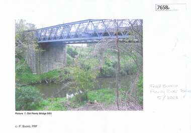
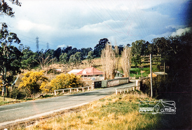 Eltham District Historical Society Inc
Photograph, Old Lower Plenty Bridge and Hotel
Colour photograph of Lower Plenty Bridge from the west prior to opening of new bridge. Hotel in background. 4 x 6 print and also laminated 8 x 10 print.lower plenty, main road, plenty river, golf club hotel, hotels, bridges -
 Latrobe Regional Gallery
Drawing, BELLANY, John b. 1942, Port Seton d. 2013, Lower Plenty Gorge, 1983
Pastel on paperSigned, dated and titled 'Bellany '83 Lower Plenty Gorge' along bottom of drawing. -
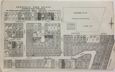 Kew Historical Society Inc
Plan - Subdivision Plan, Churchill Park Estate, Templestowe
Historic subdivision plan of the Churchill Park Estate in Templestowe.Undated subdivision plan advertising the Churchill Park Estate inTemplestowe. Streets identified in the plan include: Corroboree Place, Astley Street, Jeffrey Street, Airds Road, Dove Court, Potter Court, Thompsons Road, Richards Street, and Birchwood Avenue.Annotations in ink on the plan by agentsubdivision plans - templestowe (vic), churchill park estate - templestowe (vic) -
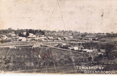 Greensborough Historical Society
Photograph - Digital Image, Greensborough township c1900, 1900s
This photograph shows a very rural Township of Greensborough around 1900.Digital copy of black and white photographmain street greensborough, greensborough