Showing 4461 items
matching point
-
 Glenelg Shire Council Cultural Collection
Photograph - Photograph - Main Breakwater construction, Portland, Oct-54
Port of Portland Authority ArchivesBack: Purple Harbour Trust Stamp. Print No. 4/43 Neg No 273 Date taken 1-10-54 Subject Main Breakwater from Battery Pointport of portland archives, main breakwater, construction, portland harbour, euclid truck, machinery -
Glenelg Shire Council Cultural Collection
Photograph - Photograph - Quarry, Pebbly Beach Blacknose Point, 05/11/1952
Port of Portland Authority ArchivesFront: 'PEBBLY BEACH 5..11.52 Looking south from Blacknose Point' Typed on bottom border Back: Purple PHT stamp 15/5 - top left in penport of portland archives -
 City of Kingston
Pamphlet - Black and white, Robert McCamish & John Gilpin (Vendors), For Private Sale Station Entrance Estate, Highett, 1930s
Sales plan for land in the suburb of Highett, bounded by Wickham Road, Railway Parade, Highett Road and Point Nepean Street. The developing urban area of Highett within the City of Kingston. This land sale pamphlet illustrates the subdivision of land within the municipality and the changing demographic of the district as new houses are constructed. The extension of the railway line from the city to Mordialloc opened up the land for development.Black and white pamphlet advertising for private sale the Station Entrance Estate, Highett. Incorporates a map of the estate bordered by Wickham Road, Railway Parade, Highett Road and Point Nepean Road. Handwritten in black ink on reverse: Station Entrance / Estate / Late [indecipherable]highett, land sales, estate -
 Bendigo Historical Society Inc.
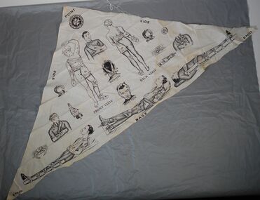
Textile - Triangular bandage
24 June 1883 is recognised as the establishment of St John Ambulance in Australia. St John Ambulance is a community-driven organisation with a 140-year history of providing First Aid in Australia.St John's Ambulance Association triangular fabric bandage with a number of illustrations of entire bodies or faces, showing how this bandage could be used in the event of injuries to various body parts. The fabric is labelled (black capital letters) BASE / ENDX / SIDEx2? POINT and two drawings of face and body read "FRONT VIEW and BACK VIEW. Numerals indicate different bandaging techniques and full figure or partial figure drawings that show how these bandages are applied to injured limbs or torso.Symbol of St John's Ambulance Association in dark black on top point of bandage.first aid, bandage, st john's ambulance -
Glenelg Shire Council Cultural Collection
Photograph - Photograph - Pebbly Beach Quarry, 05/11/1952
Port of Portland Authority ArchivesFront: 'PEBBLY BEACH 5.11.52 Looking south from Blacknose Point' - typed Back: Purple PHT stamp 15/4 crossed out - top left - penport of portland archives -
 Queenscliffe Maritime Museum
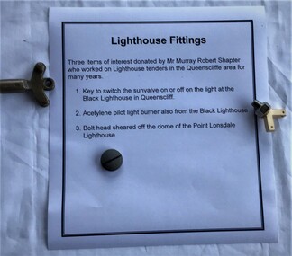
Functional object - Lighthouse fittings
Murray Robert Shapter donated these lighthouse fittings. He was a local fisherman and employee of the Public Works Lighthouse service for many years in the Queenscliff and Point Lonsdale area.Fittings from two lighthouses in the Queenscliff / Point Lonsdale area. Key to switch sunvalve on or off and an acetylene pilot light burner from the light at the Black Lighthouse in Queenscliff, and a bolt head sheared off the dome of the Point Lonsdale Lighthouse.lighthouse maintenance, fittings -
 Parks Victoria - Point Hicks Lightstation
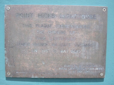
Plaque
The rectangular brass plaque commemorates the centenary of the official opening of the Point Hicks Lightstation on 15 May 1890. The engraved text in capitals reads ‘Point Hicks Lightstation/This plaque commemorates/The opening of/This Lighthouse/ (Then known as Cape Everard) /On the 15 May 1890/’. It finishes with the date of 13 May 1990. It is not known whether the plaque is a fixture attached to one of the lightstation buildings, or a detached object. If it is attached, it is defined as building fabric and is included in the Victorian Heritage Register listing for the lightstation. Details of the commemorative ceremony presumably held on 13 May 1990 are not known. It is not known whether the plaque is a fixture attached to one of the lightstation buildings, or a detached object. If it is attached, it is defined as building fabric and is included in the Victorian Heritage Register listing for the lightstation. Brass plaque with an engraved inscription. to commemorate opening of the lighthouse."POINT HICKS LIGHTSTATION/ THIS PLAQUE COMMEMORATES/THE OPENING OF/ THIS LIGHTHOUSE/ (THEN KNOWN AS CAPE EVERARD) / ON THE 15 MAY 1890 / .....13 MAY 1990" -
 Flagstaff Hill Maritime Museum and Village
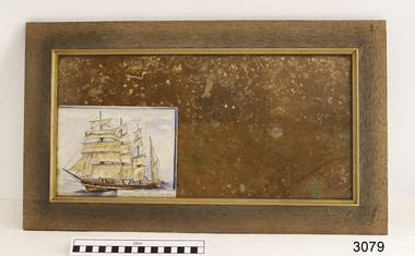
Decorative object - Wall Hanging, c. 1908
The unusual beautiful green American slate roofing tile used in this wall hanging was recovered from the shipwrecked Falls of Halladale. The iron-hulled, four-masted barque, the Falls of Halladale, was a bulk carrier of general cargo. She left New York in August 1908 on her way to Melbourne and Sydney. In her hold, along with 56,763 tiles of unusual beautiful green American slates (roofing tiles), 5,673 coils of barbed wire, 600 stoves, 500 sewing machines, 6500 gallons of oil, 14400 gallons of benzene, and many other manufactured items, were 117 cases of crockery and glassware. Three months later and close to her destination, a navigational error caused the Falls of Halladale to be wrecked on a reef off the Peterborough headland at 3 am on the morning of the 15th of November, 1908. The captain and 29 crew members all survived, but her valuable cargo was largely lost, despite two salvage attempts in 1908-09 and 1910. ABOUT THE ‘FALLS OF HALLADALE’ (1886 - 1908) Built: in1886 by Russell & Co., Greenock shipyards, River Clyde, Scotland, UK. The company was founded in 1870 (or 1873) as a partnership between Joseph Russell (1834-1917), Anderson Rodger and William Todd Lithgow. During the period 1882-92 Russell & Co., they standardised designs, which sped up their building process so much that they were able to build 271 ships over that time. In 1886 they introduced a 3000 ton class of sailing vessel with auxiliary engines and brace halyard winches. In 1890 they broke the world output record. Owner: Falls Line, Wright, Breakenridge & Co, 111 Union Street, Glasgow, Scotland. Configuration: Four masted sailing ship; iron-hulled barque; iron masts, wire rigging, fore & aft lifting bridges. Size: Length 83.87m x Breadth 12.6m x Depth 7.23m, Gross tonnage 2085 ton Wrecked: the night of 14th November 1908, Curdies Inlet, Peterborough south west Victoria Crew: 29 The Falls of Halladale was a four-masted sailing ship built-in 1886 in Glasgow, Scotland, for the long-distance cargo trade and was mostly used for Pacific grain trade. She was owned by Wright, Breakenridge & Co of Glasgow and was one of several Falls Line ships, all of which were named after waterfalls in Scotland. The lines flag was of red, blue and white vertical stripes. The Falls of Halladale had a sturdy construction built to carry maximum cargo and able to maintain full sail in heavy gales, one of the last of the ‘windjammers’ that sailed the Trade Route. She and her sister ship, the Falls of Garry, were the first ships in the world to include fore and aft lifting bridges. Previous to this, heavily loaded vessels could have heavy seas break along the full length of the deck, causing serious injury or even death to those on deck. The new, raised catwalk-type decking allowed the crew to move above the deck stormy conditions. This idea is still used today on the most modern tankers and cargo vessels and has proved to be an important step forward in the safety of men at sea. On 4th August 1908, with new sails, 29 crew, and 2800 tons of cargo, the Falls of Halladale left New York, bound for Melbourne and Sydney via the Cape of Good Hope. The cargo on board was valued at £35,000 and included 56,763 tiles of American slate roofing tiles (roof slates), 5,673 coils of barbed wire, 600 stoves, 500 sewing machines, 6,500 gallons of oil, 14,400 gallons of benzene, plumbing iron, 117 cases of crockery and glassware and many other manufactured items. The Falls of Halladale had been at sail for 102 days when, at 3 am on the night of 14th November 1908, under full sail in calm seas with a six knots breeze behind and misleading fog along the coast, the great vessel rose upon an ocean swell and settled on top of a submerged reef near Peterborough on south-west Victoria’s coast. The ship was jammed on the rocks and began filling with water. The crew launched the two lifeboats and all 29 crew landed safely on the beach over 4 miles away at the Bay of Islands. The postmistress at Peterborough, who kept a watch for vessels in distress, saw the stranding and sent out an alert to the local people. A rescue party went to the aid of the sailors and the Port Campbell rocket crew was dispatched, but the crew had all managed to reach shore safely by the time help arrived. The ship stayed in full sail on the rocky shelf for nearly two months, attracting hundreds of sightseers who watched her slowly disintegrate until the pounding seas and dynamiting by salvagers finally broke her back, and her remains disappeared back into deeper water. The valuable cargo was largely lost, despite two salvage attempts in 1908-09 and 1910. Further salvage operations were made from 1974-1986, during which time 22,000 slate tiles were recovered with the help of 14 oil drums to float them, plus personal artefacts, ship fittings, reams of paper and other items. The Court of Marine Inquiry in Melbourne ruled that the foundering of the ship was entirely due to Captain David Wood Thomson’s navigational error, not too technical failure of the Clyde-built ship. The shipwreck is a popular site for divers, about 300m offshore and in 3 – 15m of water. Some of the original cargo can be seen at the site, including pieces of roof slate and coils of barbed wire.The Falls of Halladale shipwreck is listed on the Victorian Heritage Register (No. S255). She was one of the last ships to sail the Trade Routes. She is one of the first vessels to have fore and aft lifting bridges. The Falls of Halladale is an example of the remains of an International Cargo Ship and also represents aspects of Victoria’s shipping industry. The wreck is protected as a Historic Shipwreck under the Commonwealth Historic Shipwrecks Act (1976).Wall hanging, framed slate salvaged from the wreck of Falls of Halladale. Slate is visible from both sides of TIMBER frame through glass. Coloured drawing of Falls of Halladale is inserted under glass. Typed inscription " "FALLS OF HALLADALE" "Grounded, Nov 14th, at Wreck Point, Midway between Peterborough & Bay of Islands" Typed inscription " "FALLS OF HALLADALE" "Grounded, Nov 14th, at Wreck Point, Midway between Peterborough & Bay of Islands" falls of halladale, cargo, flagstaff hill, warrnambool, shipwrecked coast, flagstaff hill maritime museum, maritime museum, shipwreck coast, flagstaff hill maritime village, great ocean road, slate, slate tile, green american slates, building material, wreck point, peterborough, bay of islands, russell & co. -
 Marysville & District Historical Society
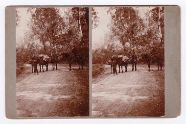
Photograph (Item) - Black and white bi-focal image, Unknown
An early black and white bi-focal image of men and packhorses on the Marysville-Wood's Point Road in Marysville in Victoria.An early black and white bi-focal image of men and packhorses on the Marysville-Wood's Point Road in Marysville in Victoria. This is now known as the Marysville-Wood's Point Road. The Marysville-Woods Point Road was originally part of the Yarra Track, constructed in the early 1860s to provide access between Healesville and the Woods Point Goldfields. Despite the steep terrain and engineering difficulties, the Yarra Track soon became a busy route used by pack horses, horse-drawn drays, and wagons. Today this sealed mountain road is a popular scenic drive between Marysville and Warburton.Packhorses on Wood'spoint Road/ Marysville/ Victoriapackhorses, wood's point road, marysville-wood's point road, marysville, victoria, yarra track, healesville, wood's point goldfields, warburton -
 Ballarat Tramway Museum
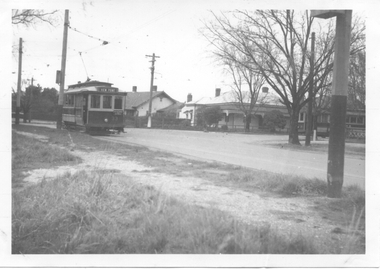
Photograph - Digital image, Wal Jack, 13/07/1944 12:00:00 AM
Yields information about the intersection of MacArthur St. and Wendouree Parade, View Point in 1944.Digital image from the Wal Jack Ballarat Album of a photograph of No 33 in Wendouree Parade and No. 21 in Macarthur St, View Point, 13-7-1944. Photo Wal Jack. No. 33 has the destination of View Point. See image i2 for rear of photograph. See image i3 for hi res scan of print. See image i4 for hi res scan of negativeOn rear of photograph in ink "SEC, No. 33 at View Point terminus in Wendouree Parade, No. 21 in Macarthur St, Ballarat 13-7-44" and in top right hand corner, Wal Jack stamp with "T62" written in.trams, tramways, view point, macarthur st, wendouree parade, tram 33, tram 21 -
 Lakes Entrance Historical Society
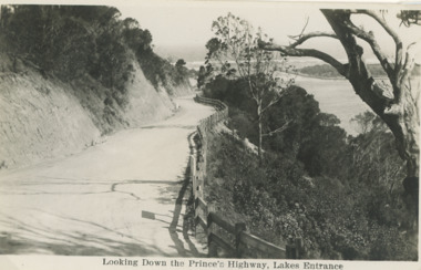
Postcard - Princes Highway Lakes Entrance, 1930 c
Princes Highway Jemmys Point showing gravel road post and rail fence freshly excavated cliff with Entrance glimpses in distance Lakes Entrance Victoria. Also a second black and white postcard taken much later of Princes Highway Jemmys Point Lakes Entrance showing sealed road with double lines in centre, post and rail fence, Entrance in distance. Donor Susan Samuel 2 January 2015. Number 04204.1Black and white postcard taken of Princes Highway Jemmys Point showing gravel road post and rail fence freshly excavated cliff with Entrance glimpses in distance Lakes Entrance VictoriaLooking Down the Princes Highway Lakes Entrancecivil engineering, roads and streets, fences -
 Lakes Entrance Historical Society
Photograph - Lakes Entrance Grid location, 1999
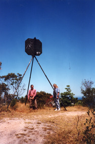
Lakes Entrance Grid reference, Cunninghame 8522.3.4 896.082, on ten acre site with trig point, it is from this point that all the survey for the surrounding areas was undertaken. Part of the Vic Geodetic Survey initiated in 1860 by Ellery Survey started from triangulation base in Werribee. (Grid ref B'dale 8422)Colour photograph of the Victoria Geodetic Survey Triangulation Station, Trig Station, situated off Ocean View Parade, Merrangbaur Hill. Location is indicated by ground point and standing structure, situated on an elevated bush block. Lakes Entrance Victoriasurveying, township planning -
 City of Kingston
Pamphlet - Colour, Stillwell and Co, The Hill Estate, Highett, 1917
Sales plan for land in the suburb of Highett, bounded by Point Nepean Road and including Sandford Street, Turner Road, Alfred Street and Peace Street.The developing urban area of Highett within the City of Kingston. This land sale pamphlet illustrates the subdivision of land within the municipality and the changing demographic of the district as new houses are constructed close to infrastructure.Colour pamphlet advertising for sale at auction The Hill Estate, Highett. Incorporates a map of the estate bordered by Point Nepean Road and including Sandford Street, Turner Road, Alfred Street and Peace Street.Handwritten in grey pencil on subdivision map next to subdivisions 91, 92, 93, 106, 107 and 108: x Handwritten in grey pencil on back cover: The / Hill Estate / Highettland sales, estate, highett -
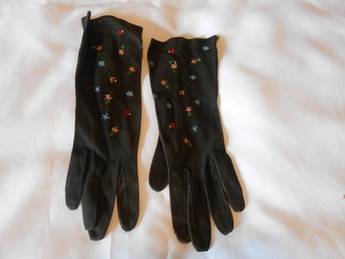 Bendigo Historical Society Inc.
Clothing - MAGGIE BARBER COLLECTION: BRACELET LENGTH BLACK SUEDE GLOVES EMBROIDERED, Late 1800's
Clothing. Black suede bracelet length gloves, embroidered with floral motifs in the Beauvais style of embroidery, and as stated inside the right glove, ''REAL BEAUVAIS POINT HAND MADE 927 6/14. Embroidery made with a hook. Fifteen tiny flowers in shades of blue, pink, red, green, are scattered across the top of the gloves.REAL BEAUVAIS POINT, HAND MADE 927 61/4 RIGHT GLOVE. MADE IN FRANCE 927,Left glove.costume accessories, female, bracelet length black suede gloves, beauvais is a french term for a form of tambour embroidery, which is decorative needlework technique using a hook. -
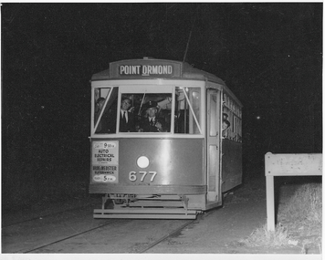 Melbourne Tram Museum
Photograph - X2 677 Point Ormond Last Car, Jim Seletto, 22 October 1960
The photograph shows X2 class tram No. 677 with the destination of Point Ormond at the western end of Glen Huntly Rd at that location. Dark exterior becasue this was 10.30pm in parkland. This was the last car before the line closed to revenue service. Photo by Jim Seletto 22 October 1960Yields information about MMTB X2 and Point Ormond terminus.Black and white photograph with photographer's notes on rear In pencil on rear: 'Last car ex Point Ormond, 10.30pm Oct 22 60. Photo J Seletto JSE10'trams, point ormond, glen huntly rd, tram 677, x2 class, trramways -
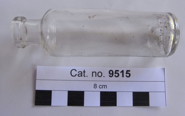 Coal Creek Community Park & Museum
Bottle, glass, 1916-1923
Cylindrical clear glass bottle with text embossed on base'AGM' with point on 'A' -
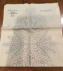 Mont De Lancey
Embroidery pattern
Calico embroidery pattern for table runner, intended for Renaissance work, or Point Lace. The blue printed pattern depicts leaves and flowers the whole length of the runner." L.B. Lacet Runner. J.W. with a crown in between the two letters, No. 4322" in top left hand corner of the runner and "Worked with Point Braid No. 261" in the top right hande corner. The same inscriptions are found repeated at the other end of the runner.household textiles., tableware, textileworking patterns -
Queenscliffe Maritime Museum
Photograph - Landed Shark
Shark fishing was important to the Queenscliff Point Lonsdale fishing industry since early 1900s. It is still a popular activity in the area today.Fishing of all kind has been an important industry in the Queenscliff region. Although commercial fishing has greatly diminished, recreational fishing is still an important activity.Laminated photograph of a shark on the crane on Fishermans Pier circa 193820 Beach Street Queenscliffe. Debbie O'Hare? [illegible]. Back of Glenuse Reef in Point Lonsdale. Whole salmon for bait 5am. In creek on crane. 2,100Lbs, 8'6" Girthshark, shark fishing, queenscliff, fishing industry -
Lakes Entrance Historical Society
Photograph - View from Jemmys Point, 1926
Also two other black and white photographs taken along the road to Jemmys Point Bullock Island in background 05002.1 and 05002.2 showing trees along roadside 7 x 11.5 cmBlack and white photograph looking uphill at Jemmys Point Road showing post and rail fence on lower side and steep roadside cutting on upper side Lakes Entrance Victoria waterways, roads and streets, islands -
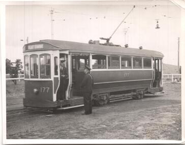 Ballarat Tramway Museum
Photograph - Black & White Photograph/s, Wal Jack, 23/02/1942 12:00:00 AM
Black & white photograph of M&MTB tram T177, at Point Ormond terminus, 23-2-1942. On rear in ink is a caption - see Inscriptions. Reimaged 17/7/2017 both front and back. On rear in ink is 'T309 M&MTB, 'T' class No. 177 in original build at Point Ormond, 23-2-42. Ex Melb. Brunswick & Coburg Tramway's car. W.Jack Photo'trams, tramways, mmtb, t class, mbctt , tram 177 -
Glenelg Shire Council Cultural Collection
Photograph - Photograph - Main Breakwater construction, Portland, Feb-54
Port of Portland Authority ArchivesBack: Purple PHT Stamp Print No. 227 Date taken 3-2-54 Subject Main Breakwater from Battery Pointport of portland archives, main breakwater, construction, battery point, harbour development -
 Kew Historical Society Inc
Photograph - Flooding of the Yarra River in North Kew, 1934
North Kew, now divided between Kew and Kew East, bordered the Yarra River. As such, it was a region subject to flooding in the Yarra Valley. Development beyond this point (ie Kellett Grove) was limited by the City of Kew's planning regulations. Prior to urban development, the area since European settlement and the first land sales in the district in the 1840s, had been used for dairy farming. Small sepia snapshot of floodwaters in North Kew. The point of view is of two houses belonging to local families that were surrounded by floodwater. Verso: HYATTS HOUSE / WILLSMERE ROAD / Stamped 3 163yarra river -- north kew, floods -- yarra valley, floods -- north kew, floods -- 1934, natural disasters -- kew, willsmere road -
 City of Kingston
Pamphlet - Colour, Roy Dunn Pty. Ltd, Central Corner Estate Moorabbin and Highett, c. 1923
Sales plan for land in the suburbs of Highett and Moorabbin, bordered by Point Nepean Road and Wickham Road East incorporating William StreetThe developing urban area of Highett and Moorabbin within the City of Kingston. This land sale pamphlet illustrates the subdivision of land within the municipality and the changing demographic of the district as new houses are constructed close to infrastructure.Colour pamphlet advertising for private sale land in the Central Corner Estate in Moorabbin and Highett. Incorporates a map of the estate bordered by Point Nepean Road and Wickham Road East, with subdivisions also available on both sides of William Street. Handwritten in blue pencil on subdivision plan: a tick is drawn on subdivisions 2-18 Handwritten in blue pencil on subdivision 6: a box with an x inside Handwritten in blue pencil on subdivisions 10 and 12: S Handwritten in black ink on front page: [indecipherable] / McKittricks Handwritten in grey pencil on rear page: McKilhick / Nepean Rd Handwritten in grey pencil on rear page upside down: 160000 / 15 8300 [crossed out] land sales, estate, highett, moorabbin -
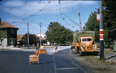 Ballarat Tramway Museum
Slide - 35mm slide/s, Ben Parle, 8/04/1958 12:00:00 AM
Kodachrome Transparency - 35mm slide - cardboard mount, with one side with red border and words "Kodachrome Transparency / Processed by Kodak" top and bottom. Photo taken by Ben Parle 8/4/1958. Has slide No. "5" stamped in black in top corner. Photo of the SEC Ballarat Ford welding truck, at the intersection of Macarthur St and Wendouree Parade, View Point Junction. Note tram stop signage. Three SEC workers in view, with road signage set up and truck connected to the overhead for welding work. Note bicycle leaning against truck. Welder - Weld For high resolution scan see btm2864.tif See Reg Item 7700 for another photo of the truck in the Power Station yard. "Drummond St. and View Point Junction Ballarat" / "8-4-58"tramways, trams, rails, welding, trucks -
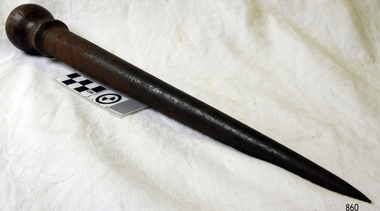 Flagstaff Hill Maritime Museum and Village
Tool - Fid, Mid 20th Century
A Fid is a conical tapered wooden tool used for separating the strands of rope for splicing. They were a tool traditionally made of wood or bone used to work with rope and canvas in marlinespike seamanship. A Fid differs from a marlinspike in material and purposes. A marlinspike is used in working with wire rope, natural and synthetic lines also may be used to open shackles, and is made of metal. A Fid is used to hold open knots and holes in the canvas, and to separate the "lays" (or strands) of synthetic or natural rope for splicing. A variation of the Fid, the gripfid, is used for ply-split braiding. The gripfid has a jamming cleat to pull a cord back through the cord split by the fid's point. Modern Fids are typically made of aluminium, steel, or plastic. In addition to holding rope open to assist the creation of a rope splice, modern push fid's have markings for precise measurements in a variety of sizes of rope. The length of these fid’s is typically 21 or 22 times the diameter of rope to be spliced. Fids have been used since sailing vessels were first used to travel the worlds seas the tool was invented to be used to splice rope and with working with canvas sails. A Fid is a sailors tool that has maintained its general design for hundreds of years and gives a snapshot into what the working life was like for sailors on board sailing ships for hundreds of years. The tool in its original design is still in regular use today by recreational sailors all over the world to splice and join lengths of rope.Metal Fid with a wooden bulb on top metal body tapering to a point. Noneflagstaff hill, warrnambool, shipwrecked-coast, flagstaff-hill, flagstaff-hill-maritime-museum, maritime-museum, shipwreck-coast, flagstaff-hill-maritime-village -
Glenelg Shire Council Cultural Collection
Photograph - Photograph - Main Breakwater construction, Portland, Mar-54
Port of Portland Authority ArchivesBack: Purple PHT Stamp - Print No - 4/34 Neg. No. 231 Date taken 2.3.54 Subject Main Breakwater from Battery Pointport of portland archives, battery point, main breakwater, construction, harbour, portland -
 City of Kingston
Pamphlet - Colour, Stillwell and Co, The Hill Estate Highett Great Subdivisional Auction Sale, 1917
Sales plan for land in the suburb of Highett, bounded by Point Nepean Road and incorporating Sandford Street, Turner Road, Alfred Street, Peace Street and Tennyson Street. .The developing urban area of Highett within the City of Kingston. This land sale pamphlet illustrates the subdivision of land within the municipality and the changing demographic of the district as new houses are constructed.Colour pamphlet advertising subdivisional auction sale of the Hill Estate Highett. Incorporates a map of the estate bordered by Point Nepean Road and encompassing Sandford Street, Turner Road, Alfred Street, Peace Street and Tennyson St. Handwritten in grey pencil on reverse: Hill Street / Jamieson Handwritten in blue pencil on reverse: The Hill Estate Handwritten in blue pencil on subdivision map: [tick] [on majority of properties marked on map]highett, land sales, estate -
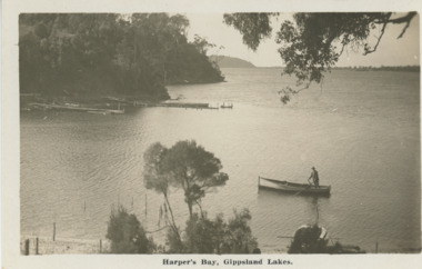 Lakes Entrance Historical Society
Postcard - Harpers Bay Lakes Entrance, H D Bulmer, 1925 c
Harpers Bay showing the jetty where tourist launches moored for passengers to land and walk up to Mrs Westersons Cliffcrest Tea Rooms, Jemmys Point in distance Gippsland Lakes VictoriaBlack and white postcard of Harpers Bay showing the jetty where tourist launches moored for passengers to land and walk up to Mrs Westersons Cliffcrest Tea Rooms, Jemmys Point in distance Gippsland Lakes VictoriaHarpers Bay Gippsland Lakesbridges, islands, waterways, gippsland lakes -
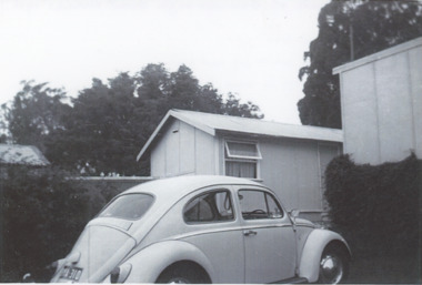 Lakes Entrance Historical Society
Photograph, Rhonda Newberry, Gainsborough Guest House Huts Lakes Entrance Victoria, 1966
Hut at rear of Gainsborough Guest House Jemmys Point with two door Volkswagon Beetle parked in front, Lakes Entrance Victoria. c1966 Each Hut contained water jug and basin, bathroom and toilet in main guesthouseBlack and white photograph showing basic tourist accommodation. hut at rear of Gainsborough Guest House Jemmys Point with two door Volkswagon Beetle parked in front, Lakes Entrance Victoria. c1966accommodation, guesthouses -
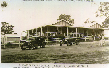 Lakes Entrance Historical Society
Photograph - Gainsborough House, 1925c
Gainsborough House was built of boxed poured concrete by Leslie Paynter and his father William Henry Paynter. It was opened about Christmas 1923 or 1924.Black and white photograph of Gainsborough House, Jemmys Point, showing an attractive accommodation house with veranda on front and north side. It is of concrete construction with iron roof. Guests on veranda and couple standing on road. Two soft top motor cars parked on road. Lakes Entrance VictoriaGainsborough House Jemmys Point Lakes Entrance.L Paynter, Proprietor, Phone 46, Moderate Tariff. Excellent Cuisine, Golf, Tennis, Shooting, Fishing, Surfing, Bathing.guesthouses, transport, people