Showing 2264 items matching "proposed"
-
 Whitehorse Historical Society Inc.
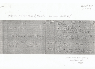
Document, Township of Norwich, C1860
List of names from Titles OfficeList of names from Titles Office concerning proposed Norwich Village Vermont 1850sList of names from Titles Officeland titles, norwich village, vermont, graham, thomas, easey, william, moule, lobb, john, gale, alfred chaplin -
 Whitehorse Historical Society Inc.
Pamphlet, Stonestown, c. 1959
Brochure on a proposed shopping centre on the southwest corner of Canterbury and Springvale Roads Forest Hill.Brochure on a proposed shopping centre on the southwest corner of Canterbury and Springvale Roads Forest HillBrochure on a proposed shopping centre on the southwest corner of Canterbury and Springvale Roads Forest Hill.shopping centres, springvale road, forest hill, canterbury road, forest hill, stonestown -
 Whitehorse Historical Society Inc.
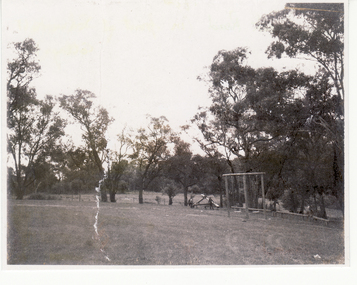
Photograph, Schwerkolt Cottage, 1976
Black and white photo of picnic grounds below Schwerkolt Cottage, site of proposed Freewayschwerkolt cottage, freeways -
 Whitehorse Historical Society Inc.
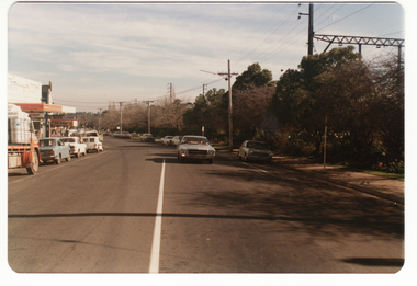
Photograph - Coloured photograph, South Parade, Blackburn, 2/08/1979 12:00:00 AM
Coloured photo of South Parade, Blackburn showing area of proposed railway extensions in 1979blackburn railway station, south parade -
Canterbury History Group
Map - Victorian Railways East Camberwell to Laburnum. Diagram No.3' 58, 1/05/1958 12:00:00 AM
Diagram showing proposed signal and interlocking arrangements for the East Camberwell to Laburnam line 1958canterbury, canterbury station, victorian railways, railway lines -
 Wodonga & District Historical Society Inc
Map - Boorgunyah - "The Town that never was"
At the height of the river trade, there was a town surveyed and laid out, and streets were named. This town was to house the workers at the river port of Red Bank when the paddle steamers plied the Murray River as far as Albury, carrying produce such as wool and wheat to the various towns along the river in the 1800s. As the river trade died away, this town never went ahead – one might say, “The town that never was.” A lone gum tree stands on the site today.This item is significant because it documents plans which were made for the early development of Wodonga.A black an white map depicting the proposed location of the township. The map is based on a sketch and is not to scale,early wodonga, boorgunyah - "the town that never was", wodonga heritage -
 St Patrick's Old Collegians Association (SPOCA)
Photograph - SPOCA, Annual Dinners
-
 Kew Historical Society Inc
Plan - Subdivision Plan, J R Mathers & McMillan, Glenferrie Road, Cotham Road, Belmont Avenue, Stirling Street, 1910-1930
Pru Sanderson, in her groundbreaking ‘City of Kew Urban Conservation Study : Volume 2 - Development History’ (1988), summarised the periods of urban development and subdivisions of land in Kew. The periods that she identified included 1845-1880, 1880-1893, 1893-1921, 1921-1933, 1933-1943, and Post-War Development. These periods were selected as they represented periods of rapid growth or decline in urban development. An obvious starting point for Sanderson’s groupings involved population growth and the associated economic cycles. These cycles also highlighted urban expansion onto land that was predominantly rural, although in other cases it represented the decline and breakup of large estates. A number of the plans in the Kew Historical Society’s collection can also be found in other collections, such as those of the State Library of Victoria and the Boroondara Library Service. A number are however unique to the collection.The Kew Historical Society collection includes almost 100 subdivision plans pertaining to suburbs of the City of Melbourne. Most of these are of Kew, Kew East or Studley Park, although a smaller number are plans of Camberwell, Deepdene, Balwyn and Hawthorn. It is believed that the majority of the plans were gifted to the Society by persons connected with the real estate firm - J. R. Mathers and McMillan, 136 Cotham Road, Kew. The Plans in the collection are rarely in pristine form, being working plans on which the agent would write notes and record lots sold and the prices of these. The subdivision plans are historically significant examples of the growth of urban Melbourne from the beginning of the 20th Century up until the 1980s. A number of the plans are double-sided and often include a photograph on the reverse. A number of the latter are by noted photographers such as J.E. Barnes.A ‘proposed’ subdivision of the area in the vicinity of Cotham and Glenferrie Roads and Belmont Avenue depicts an alternate vision for how the land might be divided into lots. When comparing this undated proposed subdivision with a modern map, it is possible to see why the subdivision did not eventuate. The right-of-way shown in the plan as beginning in Belmont Avenue was to be extended much further, preventing the lower lots from being created in the proposed shapes. Identifying the date of the name change may assist in the dating of the proposed subdivision. In faded writing at the top of the plan is an annotation referring to ‘Abbotsford’ and Finlayson’s Agency.subdivision plans - kew, glenferrie road, cotham road, belmont avenue, stirling street -
 Ringwood and District Historical Society
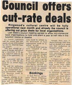
Newspaper - Clipping, The Ringwood Cultural Centre, Mines Rd., Ringwood. Council offers cut-rate deals
Newspaper clipping explaining Ringwood Council's plan to offer regular non-commercial local organisations cut price deals for regular events in the function rooms or theatre. The Cultural Centre was to be fully operational in a month's timeCr Lawrie Lawrenson proposed that there be only one concessional event per year per organisation, whereas Cr Gerald Smart proposed that such organisations should pay concessional rates for all their functions and events. Cr Smart's amendment for unlimited cut rates was unsupported. -
 Bendigo Military Museum
Document - Army Topographic Support Establishment: Preferred In-House Option, 1 23 Nov 1993, .2 30 Nov 1994, .3 14 Jun 1995
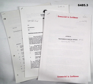
.1 The Preferred In-House Option (PIHO) proposes to meet the full requirements of the Request for Tender (RFT) by disestablishing Army Survey Regiment and establishing a new organisation which they have named the Defence Topographic Support Establishment (DTSE). It is proposed to locate the DTSE at Bendigo in the GFE facilities offered by the Commonwealth. The DTSE will be staffed by 140 Defence civilians, principally sourced from ex-RASvy members transferring to the Public Service under the provisions of Section 81B of the Public Service Act. Any existing civilian members excess to DTSE requirements are proposed to be managed within the terms and conditions of the Australian Public Service Redeployment and Retirement (Redundancy) Award 1987. Military members who elect to remain in the Service will be subject to redeployment or retraining in accordance with Service requirements. .2 Proposed re-organisation of Product Construction Squadron (PCS). Due to the transfer of Image and capture Sections to Digital Acquisition Squadron wef Jan 1995 it has been necessary to review the structure of those elements remaining within PCS. The review highlighted that there was an imbalance between Mapping and Digital products Troops. This could only be resolved by collapsing these two Troops into one single production element. This would halve the senior administrative personnel needed thus allowing them to be employed in other higher priority technical areas. The proposed restructure of PCS is outlined in Annex A with redundant personnel listed in Annex B. The combined Troop is to be designated "Construction Troop" and comprises 1 Offr and 69 ORs. The role of this Tp would be to perform all digital production. It is further divided into small and Large Format Sections. This division is functionally based and reflects the hardware and software configurations now resident within the Sqn post system upgrade. .3 During the transition period leading to full implementation of the PHIO, the Army Svy Regt and DTSE (later ATSE) will at times operate concurrently whilst Army Svy Regt scales down production and progressively transfers all technical functions to DTSE. army Svy Regt and 4 Fd Svy Sqn will continue programmed production activities until declared operationally ineffective, however a contingency mapping capability will be maintained throughout the period of implementation. Implementation of the PHIO involves a number of related activities including staff recruitment, equipment acquisition and transfer of technical responsibility. This instruction details the coordination of these and related implementation activities. .1 Preferred In-House Option, Army Topographic Support Establishment. Summary of Tender. 10 x pages typed text and schematic diagrams. .2 Proposed reorganisation - product Construction Squadron. 9 x pages typed text and schematic diagrams. .3 Implementation of the Commercial Support Program (CSP) Digital Topographical support to the Australian Defence Force (ADF). Preferred In-House Option 14 Jun 1995. 22 x pages typed text and schematic diagrams. royal australian survey corps, rasvy, fortuna, army svy reg, army survey regiment, atse -
4th/19th Prince of Wales's Light Horse Regiment Unit History Room
Work on paper - Working Papers, Mounted Troop Work File, JAN 1979 to DEC 1980
The mounted troop did not eventuateA 2-ring binder containing correspondence and working papers regarding a proposed mounted troop for the Regimentmounted troop, scheuch-evans -
Port Melbourne Historical & Preservation Society
Letter - Proposed work, Holy Trinity Anglican Church, Port Melbourne, Larsen
Copy of letter giving detailed instructions for proposed work to be done to the Church of England. Addressed to an architect.religion - anglican (holy trinity), mr philip, mr larsen -
Port Melbourne Historical & Preservation Society
Plan - Proposed land sub-division, west of railway, Sandridge, 19 Nov 1866
1866 plan of proposed sub-division of land at Sandridge, west of railway. Includes manure depot.J. Noone (Photolithographer, Dept. of Lands and Survey) J. Hardy (Assistant Surveyor)town planning, town planning - proposals shelved, j noone, j hardy -
Whitehorse Historical Society Inc.
Pamphlet, Public Meeting, 1994
Pamphlet re public meeting on proposed amalgamation of Nunawading and Box Hill, 3 Nov 1994.Pamphlet re public meeting on proposed amalgamation of Nunawading and Box Hill, 3 Nov 1994.Pamphlet re public meeting on proposed amalgamation of Nunawading and Box Hill, 3 Nov 1994.local government, city of nunawading, city of box hill, amalgamations -
Whitehorse Historical Society Inc.
Article, Greenways site saved, 2014
A shared pathway is proposed to be constructed the length of the reservation.A shared pathway is proposed to be constructed the length of the reservation, and community opinion is being sought regarding the expense.A shared pathway is proposed to be constructed the length of the reservation.greenways, healesville freeway reservation -
Whitehorse Historical Society Inc.
Map, Blackburn East Primary School
Proposed master plan 1955?Proposed master plan 1955? With Public Works Dept. detail survey 1979. Rolled map.Proposed master plan 1955? blackburn east primary school no. 4800, public works department -
Whitehorse Historical Society Inc.
Document, Yarran Dheran, 4/07/1969
A report on the establishment of a native plant reserve in the City of Nunawading. Includes detailed proposed development plans.native plants, yarran dheran -
 Whitehorse Historical Society Inc.
Photograph, Colombo Street Mitcham, 2006
Coloured photo of land for proposed development of a fourteen storey apartment block in Colombo Street, Mitchamcolombo street mitcham, high-rise buildings -
 Falls Creek Historical Society
Map - Sun Valley, Falls Creek, 1966
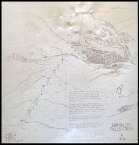
This hand drawn map shows the Gully Chair, Summit Tow and the Village Tow. It also highlights the Nursery Poma. Several buildings can be seen along with the Visitor Centre in the Gully carpark, Skyline can can be seen adjacent to the Gully Chair. The Sun Valley T-Bar was designed by Ron McCallum and began operation in 1967. It had a length of 826 metres and an elevation of approximately 200 metres. In 1989 the Sun Valley T-Bar was replaced by the Scott Quad. Ron McCallum was a founder of Alpine Developments. It appears that his first lift was the Skyline portable tow at Falls Creek in 1954. As an engineer, he went on to build about 20 chairlifts and T-bars in the 1960s and early 1970s including at least five at Falls Creek. This map is significant because it shows plans for the development of a major tow at Falls Creek in the 1960s.A framed black and white concept map for the proposed new lift in Sun Valley, Falls Creek.sun valley tow, ron mccallum, falls creek tows -
Canterbury History Group
Document - Plan for the proposed laundry at Canterbury Bowling Club, 1986
Plans for the proposed laundry at Canterbury Bowling Club cnr Kendall Street and Chaucer Street Canterburycanterbury, canterbury bowling club, kendall street, chaucer street, lawn bowls, plans, laundries -
Port Melbourne Historical & Preservation Society
Plan - Proposed street layout for North Sandridge, 1870
Plan of proposed street layout for North Sandridge to illustrate handwritten proposal (Reg. No. 127.1) 1870james blackburn, town planning - proposals shelved -
 University of Melbourne, Burnley Campus Archives
Plan, L.R.B. Simmons, New Soil Science Laboratory, 1973
Plans by Govt. Of Victoria Public Works Dept.: L.R.B. Simmons (Senior Project Architect), D.C. Bradbury (Chief Architect), Drawn by Aldo Bellarmo. A. Proposed addition to existing laboratory. B. Plan of Section and Elevation of proposed new Soil Science laboratory.laboratory, glasshouse, l.r.b. simmons, d.c. bradbury, aldo bellarmo -
 Flagstaff Hill Maritime Museum and Village
Document - Plan, Victorian Harbours Warrnambool, Victorian Harbours, Warrnambool, Plan to Accompany Sir John Coode's Report, 28-02-1879
This plan is of great significance to the local history of Warrnambool, in particular the Breakwater and its impact on Warrnambool's maritime and trade history. The plan shows the existing jetties at the Port of Warrnambool, plus the partially erected Breakwater and proposed works to the Breakwater by both the Borough of Warrnambool Surveyor and Sir John Coode. The plan was signed 28th February 1879 by Sir John Coode. The legend at the bottom left describes the existing works and the proposed works. The Warrnambool Breakwater Sir John Coode was a British harbour engineer. He was brought to Melbourne by the Melbourne Harbour Trust to advise on works to improve the Port of Melbourne. The Victorian Government commissioned him to present a plan to complete the Warrnambool Breakwater. His original plan was too expensive so he prepared a revised plan for a shorter structure. The work was completed in 1890. The construction proved to be too short to protect adequately from the weather and didn't allow enough depth for larger vessels to come into port. The decreasing trade was further affected by siltation in the bay due to the breakwater, and the completion of the railway line. The situation of the harbour became a real problem that, by 1910, required continuous dredging. In 1914 the Breakwater was extended but proved to be a failure because the work began to subside and by 1920 about two thirds of the harbour was silted up. Alterations made in the 1920's increased the silting problem and by the 1940's the harbour was no longer used. More alterations were made in the 1950's and 1960's. The Warrnambool Breakwater is registered as a place of significance on the Victorian Heritage Database. This plan of the proposed works for the existing Warrnambool Breakwater is of great significance to the local history of Warrnambool, in particular the Breakwater and its impact on Warrnambool's maritime and trade history. The Warrnambool Breakwater is registered as a place of significance on the Victorian Heritage Database (VHR H2024). It is historically significant to Victoria as one of the most important maritime engineering projects in Victoria in the late 19th century. The Warrnambool Breakwater is of historical significance as one of the most important maritime engineering projects in Victoria in the late nineteenth century. It is evidence of Victoria's nineteenth century investment in regional port infrastructure and the development of Victorian coastal shipping. It is of significance for its association with the English civil engineer Sir John Coode, the most distinguished harbour engineer of the nineteenth century, who was brought to Victoria to advise on works to improve the Port of Melbourne, but was retained by the Government to advise on improvements to the harbours at Portland, Geelong, Port Fairy, and Lakes Entrance, as well as Warrnambool. His projects for Melbourne, Lakes Entrance and Warrnambool were major engineering projects of the nineteenth century. The breakwater is historically significant as a reminder of Warrnambool's early maritime history as a Western District port, and as one of Victoria's major 'outer ports'. While the Warrnambool Breakwater is a demonstration of the engineering skills of the nineteenth century, it also demonstrates the limitations of knowledge relating to sedimentology at the time and the confidence apparent in a number of nineteenth century plans which assumed that natural forces could be overcome or contained by engineering.Plan of Warrnambool Harbour, Port of Warrnambool, dated 28 Feb 1879. Plan shows existing Breakwater and work proposed by both Warrnambool Borough Surveyor and Sir John Coode. Plan has gold coloured quarter-dowel rods top and bottom and a metal ring at the top. Stamped with title. Signed by Sir John Coode.Stamped "VICTORIAN HARBOURS / WARRNAMBOOL / PLAN / to accompany / SIR JOHN GOODE'S REPORT / DATED 28 FEB 1879" Signature "John Coode"flagstaff hill, warrnambool, maritime museum, shipwreck coast, great ocean road, sir john coode, borough of warrnambool surveyor, plan of warrnambool, victorian harbours, warrnambool harbour, warrnambool breakwater, port of warrnambool, vhd vhr h2024, flagstaff hill maritime museum & village, maritime village, map, chart, plan, lady bay, breakwater, jetty, pier, vhr h2024, proposed works, 1879 -
Federation University Historical Collection
Document - Fourth University, Documents relating to a Fourth University for Victoria collected by E.J. Barker
E.J. Barker is a past principal of the School of Mines Ballarat and the Library at the Mt Helen Campus is named after him. School of Mines is a predecessor of Federation UniversityVarious Letters, Reports Newspaper articles and notes collected by E.J. Barker on the proposed Fourth University for Victoria victorian institute of colleges staff association, r.w. hinkley, e.j. barker, ballarat institute of advanced education, vicsac, fourth university, summary, k.l jennings, mr swanson, australian universities commission, plea on varsity staff rejected, list of visitors, professor p.h. karmel, professor f.b. bull, sir ernest coates, dr w.l. hughes, sir samuel jones, professor a.r. main, professor p.h. partridge, r.a. simpson, professor sir sydney sunderland, t.b. swanson, r.h. arthur, a. freebody, sir willis h. connolly, l.h.s. thompson, geelong advertiser, newspaper articles, the age, i.c. smith, city of ballarat, j.a chisholm, 16 named to plan fourth university, newsletter, report, future developement of tertiary education, summary of statements, education age, m.b. john, tertiary education advisory council, a.s buchanan, the chartered engineer, dr. d.m. myers, r. law, victorian institute of colleges, a.s. craig, meetings, mr hamer, h.p. mason, bendigo institute of technology, mary p. lawn, k.d. green, premiers department, recommendations, k. beazley, a.m mackinnon, gordon institute of technology, e. szomanski -
Federation University Historical Collection
Plan, Plan of 130 Victoria Street, Ballarat East, 1989, 1989
A colour photocopy of a plan of the proposed layout of dwelling and Student Dining / Kitchen Amenity at 130 Victoria Street.student residences, ballarat school of mines, 130 victoria street -
Federation University Historical Collection
Plan, Ballarat School of Mines Amenity Centre, 1979, 06/1979
A 'birds-eye' (axonometric) of the proposed Ballarat School of Mines Student Centre, later named the Amenities Building.ballarat school of mines, amenities building, buildings, student amenity centre, ewan jones and associates, architects, vic mckay, plan -
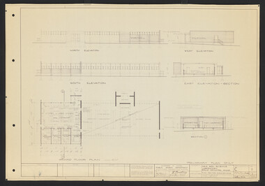
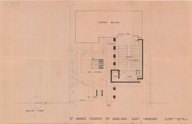 City of Moorabbin Historical Society (Operating the Box Cottage Museum)
Plan - Extension Plans for St.Anne's Church of England, Moylan Street, East Ormond
St Anne's Church of England in Moylan Street, East Ormond was closed in 1995. These plans were drawn up to add an extension to the existing church - but it was never built.Example of the progress of the Municipality of MoorabbinArchitectural Drawings for St Annes Church of England East Ormond - proposed plans for extension 2 pagesst anne's church of england, moylan street, east ormond, religion, building plans -
Port Melbourne Historical & Preservation Society
Document - Port Melbourne Council proposed schedule of works, 1974 - 1978
Retained by donor from his service on Port Melbourne Council 1973-78Miscellaneous Port Melbourne Council documents 1974-78 Proposed schedule of works, 18 April 1978local government - city of port melbourne, town planning, glen cosham -
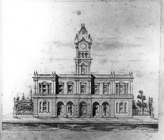 Port Melbourne Historical & Preservation Society
Drawing - Port Melbourne Town hall
A photograph of a sketch of the proposed Port Melbourne Town Hall, which was built as shown except for the top of the tower. port melbourne town hall, built environment - civic -
Whitehorse Historical Society Inc.
Article, Proposal to rezone land, 1992
Nunawading Council proposes to rezone land in Vermont South from public open space to restricted business.Nunawading Council proposes to rezone land in Vermont South from public open space to restricted business.Nunawading Council proposes to rezone land in Vermont South from public open space to restricted business.city of nunawading, rundle, geoff, grigg, vernon, local laws, vermont south