Showing 945 items matching "reservoir"
-
 Southern Sherbrooke Historical Society Inc.
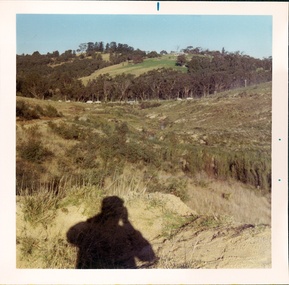
Photograph - Cardinia Creek area, Narre Warren East, prior to dam works
A set of four colour photos showing the area around where Cardinia Reservoir is now located. The photos show various views of the hillsides and valleys prior to the damming of Cardinia Creek. Each photo has 'Belgrave Cardinia Creek' handwritten on the back. They date from prior to May 1970. The set was donated to the society by David Howe. 'Belgrave Cardinia Creek' handwritten on the back of each photo. -
 Warrnambool and District Historical Society Inc.
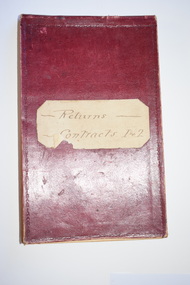
Administrative record - Warrnambool Water Trust Notebook, late 19th century (1892-1900)
This notebook appears to be the Warrnambool Water Trust Records of two contracts in 1892 . (The reference is written as 'W.W.Trust'.) The first contract, with the contractors, Coates and Reed, is for the excavation for settling tanks and clear water basin and a reservoir in Liebig Street and there are 60 pages giving details of these works - labour, masonry, concreting, fencing etc. The second contract with the contractor, William Kellas, is for the erection of a cottage and an engine shed and boiler room (7 pages). The Warrnambool Water Trust was set up in 1891 and the first project was the supply of water from the Merri River near Wollaston to a reservoir and tower in Liebig Street and this notebook concerns some details of this early water supply scheme. This notebook is of some interest as it supplies details of a late 19th century Warrnambool water supply scheme and so should be of value to local history researchers This is a notebook with a red leather cover and pages with printed headings and ruled red lines. The pages contain handwriting in black ink. The cover has a label (partly torn) with handwriting.Returns Contracts 1 & 2warrnambool water supply, warrnambool water board, 19th century water in warrnambool -
 Stawell Historical Society Inc
Photograph, Man standing in paddock in front of Hut with hill behind believed to be the Sugarloaf -- Probably the McKay's property owned by McKay's
Man standing in paddock in front of Hut with hill behind believed to be the Sugarloaf. Probably the McKay's property owned by McKay's (2011). Originally part of Allanvale owned by the Bowtell Family. Located at the end of Graces Hill Road and continuation of Panrock Reservoir Road Extension. stawell -
 Glen Eira City Council History and Heritage Collection
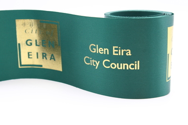
Ribbon
This ribbon was used for the opening of Booran Reserve at the corner of Booran and Glenhuntly Roads on Tuesday 11 April 2017. The Reserve was officially opened by the Mayor, Cr. Mary Delahunty and The Hon. Philip Dalidakis, MP, Minister for Innovation. The site of the Reserve was previously the Caulfield Service Reservoir.Forest green polyester ribbon printed with gold "City of Glen Eira" logo City of GLEN EIRA booran reserve, glen eira city council, park, opening, caulfield service reservoir -
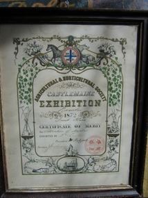 Harcourt Valley Heritage & Tourist Centre
Award Certificate, 1872
William Eagle was a pioneer orchardist in Harcourt, who brought a dray load of apple seedlings to Harcourt from Watmough’s orchard, Greensborough in 1857 to launch the industry for which Harcourt has become famous. By 1872 his orchard, in Reservoir Road, Harcourt, was fully in bearing.A reminder that Harcourt orchards came into prominence within 15 years of establishment and Harcourt Apples have taken a pre-eminent position in the State’s horticulture industry ever since. Certificate describing the winner of the Collection of Apples category. Beautiful Certificate displays Castlemaine Agricultural and Horticultural emblem as well as various pictures of aspects of agricultural and horticultural pursuits.Agricultural and Horticultural Society of Castlemaine Exhibition November 1872, Certificate of Merit for Collection of Apples, Exhibited by Wm Eagle,President W Halford, Secretary J Collings -
 Tatura Irrigation & Wartime Camps Museum
Photograph, 24/3/1917
Taken by photographer for State Rivers and Water Supply Commission.Medium sized black and white photograph. Sugarloaf Reservoir upper core wall, tower, tunnel, and lower dam under construction / Group of men left corner / Rocks in river bed foreground / Horse and cart off-centre left / Horse, cart, and men far right of centre / Words "Diversion Core Wall Tunnel and Riverbed" printed.victorian state rivers and supply commission, sugarloaf reservoir -
Tatura Irrigation & Wartime Camps Museum
Photograph, 31/3/1916
Taken by photographer for State Rivers and Water Supply Commission.Medium sized black and white photograph. Sugarloaf Reservoir pay day / R. Burns, Senior Constable Waters, P. Descrimes, G Robinson and other men grouped around the short-sleeved paymaster / Pay books on trestle table on construction site / Timber chute running down hill beyond men / All men wearing hats.victorian state rivers and supply commission, sugarloaf reservoir -
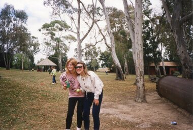
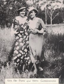 Linton and District Historical Society Inc
Photograph, Pat Ryan and Kath Cunningham
Pat Ryan, born 1919, was a daughter of Jim Ryan, hairdresser and tobacconist. She moved to Linton as a child in 1926 when her father bought the former Bennett/Todd shop in 1926. Katherine Veronica Cunningham was born at Cape Clear in 1907. Pat Ryan and Kath Cunningham were members of the Linton Amateur Dramatic Society in the 1930s and 1940s. (See programmes in LDHS for Amateur Dramatic Society productions.) Kath Cunningham worked at the Railway Hotel. She was on the committee which organised Linton's centenary celebrations in 1939.Enlarged black and white copy of original photograph, which shows two young women dressed stylishly, wearing hats and dress shoes. The woman on the left has a purse or small clutch bag in her hand, and the woman on the right has a handbag tucked under her arm. The photograph was taken in an outdoor setting, possibly near Linton Reservoir.pat (patricia) ryan, kath (kathleen) cunningham -
 Greensborough Historical Society
Photograph, Maroondah aqueduct pipe bridge 2011, 2011_
in 1891 the Watts River (near Healesville) was tapped. It supplied water to Melbourne, via the Maroondah aqueduct. The Maroondah Reservoir, northeast of Melbourne, was completed in 1927 and water was piped via the Maroondah aqueduct to the northern suburbs. It was replaced by large pipes in the 1980s. Parts of the aqueduct structure remain.Copy of colour photographaqueduct pipe bridge greensborough, maroondah aqueduct -
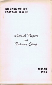 Greensborough Historical Society
Book - Annual Report, Diamond Valley Football League, Diamond Valley Football League. Annual Report and Balance Sheet. Season 1965, 15/03/1965
A complete record of the DVFL season 1965, includes financial report, description of events, membership, teams, scores from the seasons games and winners of best and fairest awards for all divisions and age groups. In 1965 the Division 1 Premiers were Reservoir Lakeside Football Club.This annual report covers many teams from within the Diamond Valley area. Includes junior and senior teams.Foolscap size book. 42 pages, printed on single sides of page . Larger buff cover with black text and. Includes typed tables. australian rules football, greensborough football club, diamond valley football league, dvfl, northern football league, nfl, northern football netball league, nfnl, reservoir lakeside football club -
 Broadmeadows Historical Society & Museum
Photograph - Two Adults in the Park, 1990
This photograph was taken during the 1990 Jacana Primary School Christmas picnic, believed to be held at Greenvale Reservoir, a popular recreational area in Melbourne’s northern suburbs. The image features two adults—most likely members of the teaching staff—posing together in a relaxed and festive setting. This photograph, taken during the 1990 Jacana Primary School Christmas picnic believed to be held at Greenvale Reservoir, depicts two adults—most likely members of the teaching staff—posing for a casual portrait amidst the festive outdoor gathering. The image offers valuable insight into the social and professional culture of the school during this period. Jacana Primary School, established in 1959 in Melbourne’s northern suburbs, was a community-focused institution that emphasised both academic development and social cohesion. The annual Christmas picnic was a key event in the school calendar, providing an opportunity for students, staff, and families to celebrate the end of the school year in a relaxed, natural setting. The presence of staff members in the photograph highlights the important role teachers played not only as educators but also as community leaders and role models. Their participation in such events reflects the school’s commitment to fostering strong relationships between staff and students. Photograph on glossy paper of two adults in the park.PH18289 (crossed out) PH-4209 (crossed out) PH-4868jacana primary school, christmas party, 1990, jacana -
University of Melbourne, Burnley Campus Archives
Plan, Merri Creek Management Committee Base Map, c. 1990
(1) 2 sets Base Maps Scale 1:5000 MCMC. (2.) 2 sets Merri Creek remnant vegetation Scale 1:5000.merri creek, management plan, northcote, coburg, reservoir, fawkner, thornbury, remnant vegetation -
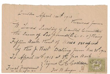 Linton and District Historical Society Inc
Receipt, Receipt for House Rent, 1913
The Reverend Joseph Best, who was church of England Vicar at Linton between 1912 and 1922, "resided for the first twelve months in a rented house next to the Police Station on the Reservoir Road". In 1912/13 the Church purchased a house to serve as a Vicarage, which was dedicated on 10th April 1913.Handwritten receipt dated 14.4.1913, from C.E. Godden on behalf of W. Angus, to W. Todd, Secretary of Central Committee [of Parish of Linton] for fifteen weeks rent, for house occupied by Rev. J. Best. Victorian Stamp Duty stamp affixed to page, initials "C.E.G." and date "14/4/13" written across it.rev. j. best, w. todd, c. e. godden, receipts -
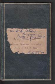 Bendigo Historical Society Inc.
Book - JOSEPH BRADY COLLECTION: NOTEBOOK, BENDIGO WATER WORKS - CRUSOE RESERVOIR AND OTHER CONTRACTS 1870 TO 1874
Dark green covered book with gold edging front and back and seven horizontal lines on the spine. On front cover: buff sticker, with Bendigo Water Works, Crusoe Reservoir and others, contracts 1870 - 1874 written in cursive script. Later writing 'from Mrs. H. Strickland, Bungoona, Currie, King Island'. Written inside is: Presented to Bendigo Historical Society by Mrs A Strickland, Bungoona, Currie, King Island. Also the Historical Society Stamp. The next page has three newspaper cuttings. The first is 'The Victorian Waterworks'. It has costings for contracts for water supply, amounts which will supply water from the Coliban to the Castlemaine and Sandhurst districts, and if the Government should purchase the Bendigo Waterworks, and to construct the Upper Coliban reservoir, additional expenditure may be required. (from Daily Telegraph - 1868). The second is some information on The Yan Yean Aqueduct. The third is a letter to the Editor of the Argus from Joseph Brady, dated August 2, 1870, in reference to repairing the leak in the outlet tunnel of the Malmsbury Reservoir. He says the repair of the tunnel was not essential and is unnecessary and 2nd. If the bank was cut through and restored, for years the bank would not be safe, as the earth used in the restoration would require time to subside and unite with the old work. He hopes the embankment would be allowed to stand intact.civil engineering, water supply, coliban, bendigo water works - crusoe reservoir and other contracts 1870 to 1874, mrs a strictland, royal historical society of victoria bendigo branch, coliban scheme, upper coliban reservoir, daily telegraph 1868, yan yean aqueduct, age, argus 2/8/1870, malmsbury reservoir, joseph brady, charles cook, fishburn morton & kennedy, bernard ward & co, the fulton foundry co ltd, james mcewan & co, laylands foundry co, melbourne sewers & water supply, c w gore, crusoe office, john mcilwraith, edward chandler, ia-s miller & co, robison br & co, guthrie/white hills pottery, peter mcpherson, slater & co, john danks, mclean br & rigg, william beebe, t i connelly, i horwoods -
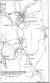 Bendigo Historical Society Inc.
Map - STATE RIVERS AND WATER SUPPLY COMMISSION : COLIBAN SYSTEM OF WATERWORKS MAP
State Rivers and Water Supply Commission. Photocopied foolscap-size map. Title: Coliban System of Waterworks. Channels, reservoirs, reticulation systems. Maldon - S.R. & W.S.C. reticulated towns. The map includes the areas from Goornong to south of Kyneton and across to Maldon: Goornong, Marong, Bendigo, Strathfieldsaye, Lockwood, Maldon, Harcourt, Castlemaine, Newstead, Elphinstone, Taradale, Malmsbury, Kyneton.state infrastructure, water supply, coliban system, state rivers and water supply commission. coliban system. -
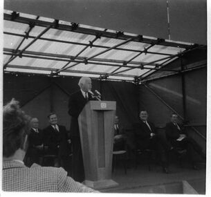 Southern Sherbrooke Historical Society Inc.
Photograph - Cardinia Reservoir's official works opening ceremony 1970
Black and white photo of the opening ceremony to mark the beginning of works at Cardinia Reservoir, May 1970. The official party is seated on a small podium beneath a temporary marquee. The Governor of Victoria, Sir Rohan Delacombe, is addressing the audience from behind a wooden podium. Seated behind him are several men including Alan Croxford, then Chairman of the Melbourne & Metropolitan Board of Works. -
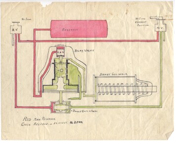 Melbourne Tram Museum
Drawing - air brake system on a Melbourne tram using a self lapping brake and relay valve, Melbourne & Metropolitan Tramways Board (MMTB), 1960's?
Drawing of the air brake system on a Melbourne tram using a self lapping brake and relay valve - the charging and release positions. 89.1 - shows the relay valve in the exhaust position 89.2 - shows the valve in the applied position. Has been drawn in ink on a piece of paper, and the coloured red or green as necessary to show the various positions and state of the valves, reservoir, brake cylinder and pipes.trams, tramways, mmtb, braking, brake valves -
 Eltham District Historical Society Inc
Photograph, Tom Prior, Maroondah Aqueduct, Research, Vic, c.1895
Built for opening in 1891 to take water from Maroondah to Reservoir. Part of a slide show presentation "Bridges & Waterways of the Shire" by Russell Yeoman to the 13 September 1989 Society meeting. The presentation included slides of historic photos from the Shire of Eltham Pioneers collections as well as several recent views.This photo forms part of a collection of photographs gathered by the Shire of Eltham for their centenary project book,"Pioneers and Painters: 100 years of the Shire of Eltham" by Alan Marshall (1971). The collection of over 500 images is held in partnership between Eltham District Historical Society and Yarra Plenty Regional Library (Eltham Library) and is now formally known as the 'The Shire of Eltham Pioneers Photograph Collection.' It is significant in being the first community sourced collection representing the places and people of the Shire's first one hundred years. The Reynolds family were early settlers in Research. The Reynolds/ Prior collection of photographs were taken by Tom Prior, the maternal uncle of Ivy Reynolds, around 1900 and the 60 photos in the album give a fine overview of many of the landmarks of Research and Eltham over 100 years ago. lvy lived in the family home for many years at 106 Thompson Cres Research. Ivy's father, Ernst Richard Reynolds and grandfather, Richard Reynolds, lived at the same address. Ivy's father Richard worked for Mr. Trail on his property in Research. Reynolds Road is named after the family. Mr Tom Prior (wife Eva) worked at the Melbourne zoo. He was very innovative and made his own camera, using the black cloth hood to exclude the light. The photographs are a reminder of the rural nature of Research and Eltham and its rich heritage.Digital image (Neg copy missing)shire of eltham pioneers photograph collection, research (vic.), maroondah aqueduct, aqueduct, reynolds prior collection -
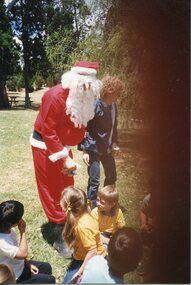 Broadmeadows Historical Society & Museum
Photograph - Santa Photograph, Father Christmas, 1990
This photograph captures a festive moment from the 1990 Jacana Primary School Christmas picnic, believed to be held at Greenvale Reservoir Park, a popular recreational area located north of Melbourne. The image features Father Christmas (Santa Claus) interacting with children during the school’s annual end-of-year celebration.This photograph is a culturally and historically significant artifact that captures a cherished moment from the 1990 Jacana Primary School Christmas picnic, believed to held at Greenvale Reservoir, a popular community gathering space in Melbourne’s northern suburbs. The image features Father Christmas engaging with students in a festive outdoor setting, symbolising the school’s commitment to creating joyful, inclusive experiences for its children. The picnic was a highlight of the school calendar, offering students a day of celebration, connection, and community spirit beyond the classroom.Photograph on glossy paper of Father Christmas with children in the park.PH18289 (crossed out) PH-4209 (crossed out) PH-4868jacana primary school, christmas picnic, 1990, jacana, father christmas -
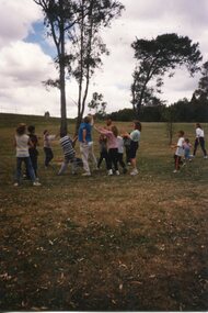 Broadmeadows Historical Society & Museum
Photograph, Ball Game, 1990
This photograph captures a dynamic and joyful moment during the 1990 Jacana Primary School Christmas picnic, believed to be held at Greenvale Reservoir, a popular recreational site in Melbourne’s northern suburbs. The image shows a group of children engaged in a casual game of football, joined by a teacher, in an open grassy area of the park.This photograph, taken during the 1990 Jacana Primary School Christmas picnic believed to be at Greenvale Reservoir, captures a moment of informal recreation in which a teacher joins students in a game of football. Set against the natural backdrop of the reservoir parklands, the image reflects the school’s emphasis on community, wellbeing, and the value of shared experiences outside the classroom.Photograph on glossy paper of a group playing games.PH18289 (crossed out) PH-4209 (crossed out) PH-4868jacana primary school, christmas party, 1990, jacana, group photograph, football -
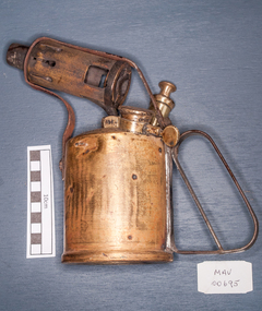 City of Moorabbin Historical Society (Operating the Box Cottage Museum)
Tools, Blow-torch brass, 20thC
A blowtorch is a fuel-burning tool used for applying flame and heat to various applications, usually metalworking. Early blowlamps used liquid fuel, carried in a refillable reservoir attached to the lamp. Modern blowtorches are mostly gas-fuelled. Their fuel reservoir is disposable or refillable by exchange. The term "blowlamp" usually refers to liquid-fuelled torches still used in the UK. Liquid-fuelled torches are pressurized by a piston hand pump, while gas torches are self-pressurized by the fuel evaporation. In 1882, a new vaporizing technique was developed by C. R. Nyberg in Sweden, and the year after, the production of the Nyberg blow lamp started. It was quickly copied or licensed by many other manufacturers. The US blowlamp was independently developed with a distinctive flared base and was fuelled by gasoline, whereas the European versions used kerosene for safety and low cost.The family of Mr Howcroft were early settlers in Moorabbin ShireA brass blow-torch B.A. HJOP Co. STOCKHOLM SWEDENblowtorch, stockholm sweden, welding, moorabbin, cheltenham, bentleigh, early settlers -
 Stawell Historical Society Inc
Photograph, Grampians at Halls Gap 1866
Grampians Halls Gap. Part of a collection of Photographs by Mr. O.G. Armstrong as commissioned by the Shire of Stawell for the Inter-colonial and Paris Exhibition in Melbourne in 1866. From about 1860 there was agitation for a water supply, not only for Stawell but for the Wimmer Mallee as well. In 1887 Wartook was adopted as the first reservoir for the Wimmer. Stawells water supply was designed by Mr. John D’Alton. The scheme came from Fyan’s Creek via Wooden Fluming and a Syphon and finally through the mountain in a tunnel, before being piped to a reservoir on Big Hill. The system was completed in December 1881 and although there have been modifications, basically it has not been changed to this day. The Wimmera Mallee stock and domestic system from the Grampians is the largest system of its kind in the world, the latest edition being like Belfield and piping of Wimmera channels. stawell -
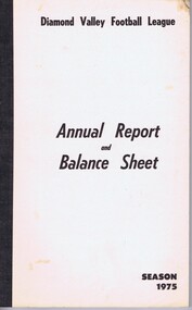 Greensborough Historical Society
Book - Annual Report, Diamond Valley Football League, Diamond Valley Football League. Annual Report and Balance Sheet. Season 1975, 1975
A complete record of the DVFL season 1975, includes financial report, description of events, membership, teams, scores from the seasons games and winners of best and fairest awards for all divisions and age groups. including black and white photos. In 1975 the Division 1 Premiers were Reservoir-Lakeside Football Club.This annual report covers many teams from within the Diamond Valley area. Includes junior and senior teams.Foolscap size book. 66 pages, printed on single sides of pages . White cover with black text and includes typed tables and black and white photosaustralian rules football, greensborough football club, diamond valley football league, dvfl, northern football league, nfl, northern football netball league, nfnl, reservoir lakeside football club -
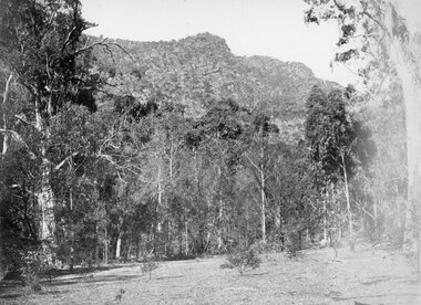
![View of Sailor’s Creek Falls / [by] Nicholas Caire, circa 1876](/media/collectors/550653872162f11fb04854aa/items/577b5d13d0cdd10948d24e07/item-media/577b5d7dd0cdd10948d282ff/item-fit-380x285.jpg) Kew Historical Society Inc
Kew Historical Society IncPhotograph, Anglo-Australasian Photographic Company, View of Sailor’s Creek Falls, c. 1876
Nicholas Caire was born on Guernsey in the Channel Islands in 1837. He arrived in Adelaide with his parents in about 1860. In 1867, following photographic journeys in Gippsland, he opened a studio in Adelaide. From 1870 to 1876 he lived and worked in Talbot in Central Victoria. In 1876 he purchased T. F. Chuck's studios in the Royal Arcade Melbourne. In 1885, following the introduction of dry plate photography, he began a series of landscape series, which were commercially successful. As a photographer, he travelled extensively through Victoria, photographing places few of his contemporaries had previously seen. He died in 1918. Reference: Jack Cato, 'Caire, Nicholas John (1837–1918)', Australian Dictionary of Biography.An original, rare photograph from the series 'Views of Victoria: General Series' by the photographer, Nicholas Caire (1837-1918). The series of 60 photographs that comprise the series was issued c. 1876 and reinforced a neo-Romantic view of the Australian landscape to which a growing nationalist movement would respond. Nicholas Caire was active as a photographer in Australia from 1858 until his death in 1918. His vision of the Australian bush and pioneer life had a counterpart in the works of Henry Lawson and other nationalist poets, authors and painters.Views of Victoria (General Series) No.32 / 'View of Sailor’s Creek Falls’ / Albumen silver photograph mounted on boardOn Reverse: ‘The Sailor’s Creek Falls are situated near Daylesford, in one of the valleys of the Jim Crow Ranges. The Creek at this particular juncture is naturally adapted for the formation of a large reservoir. The stream of water is small during summer months, but a great body of water may sometimes be seen during the winter or wet seasons.’nicholas caire (1837-1918), sailor's creek (vic), jim crow ranges, daylesford, sailor's falls, photography - landscapes - victoria -
 Kiewa Valley Historical Society
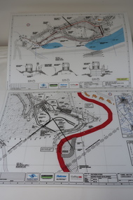
Plans - Southern Hydro - Bogong Power Development
Southern Hydro owned the Kiewa Hydro Electric Scheme in May 2006 when these plans were created. The Site No. 1 and Site No. 2 are part of the Bogong Power Development Bogong Power Development is part of the Kiewa Hydro Electric SchemeLaminated A3 plans mostly black and white but with a little color and surrounded by a grid.(Also see KVHS 1439) 1. Tunnel and Civil works / Commissioners Lodge Site Plan 1: Site No. 1 / TBN /Water /Supply / Reservoir Site 2. Tunnel and Civil Works / Pedestrian Diversion Access Paths / and Tracks: Site No. 2 / Lake Guy Site / Bogong Victoriabogong power development, southern hydro 2006 -
 Bendigo Historical Society Inc.
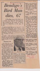
Newspaper - LYDIA CHANCELLOR COLLECTION: REDVERS EDDY OBITUARY
Newspaper clipping (Bendigo Advertiser, 5th August 1968) on backing cardboard, telling story of Redvers James Eddy, an expert of wildlife and minerals. Redvers lived near the Spring Gully Reservoir and taught chemistry at the School of Mines, Bendigo. One of his 'better known works is a record of bird sounds, calls and songs'. Also attached alongside the article are his death and funeral notice.person, bendigo, redvers james eddy -
Clunes Museum
Plan, CLUNES WATER SUPPLY
DRAWINGS MADE TO SET UP A PERMENT PIPED WATER SUPPLY TO NEW NORTH MINE, CLUNES, VICTORIA, AUSTRALIA1 PAGE PLAN WITH DRAWING OF CLUNES WATER SUPPLY ON WAXED PAPER USING RED, BLACK AND BLUE INKCLUNES WATER SUPPLY LONGITUDINAL SECTION OF CENTRE LINE OF THE LOWER AWUEDECT FROM WEIR A TO SERVICE RESERVOIR DRAWING 420 5 CONTRACT NO. 740 2 HORIZONTAL SCALE FOUR CHAINS TO AN INCH VERTICAL SCALE FORTY FEED TO AN INCH SIGNED BY OCTAVIUS LANGTREE WORKS ENGINEER 13/12/1870octavius langtree, peter lalor, clunes water supply -
 Greensborough Historical Society
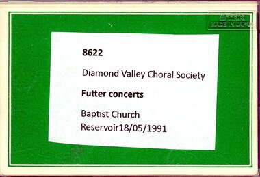
Audio - Audio Cassette, Diamond Valley Choral Society, Futter Concerts, performed by Diamond Valley Choral Society 1991, 18/05/1991
A recording of songs performed at Futter Concerts 18/05/1991, including Advance Australia Fair, Australia Fair I love you, Riding to the Never Never, Bush night, I love to go a-wandering, Waltzing Matilda. This performance is by the Diamond Valley Choral Society at Reservoir Baptist Church on 18/05/1991.2 audio cassettes in clear plastic casesHandwritten on insert: Songs included see context; typed on cassettes "Futter Concertsdiamond valley choral society, futter concerts, reservoir baptist church -
 Greensborough Historical Society
Book, Nillumbik Shire Council, 1997 Community Guide Nillumbik, 1997_
Guide to services provided by Nillumbik Shire Council. Nillumbik Shire is located 25 kilometres north-east of Melbourne and the southern boundary is the Yarra River. The south of Nillumbik is predominantly urban, with commercial centres at Eltham and Diamond Creek. The north of the municipality includes significant natural features like Kinglake National Park and Sugarloaf ReservoirAnnual guide to services in Nillumbik. 64 pages. Cover is pale yellow with colour drawings. nillumbik shire council, handbooks -
 Greensborough Historical Society
Book, Nillumbik Shire Council, 1998 Community Guide Nillumbik, 1998_
Guide to services provided by Nillumbik Shire Council. Nillumbik Shire is located 25 kilometres north-east of Melbourne and the southern boundary is the Yarra River. The south of Nillumbik is predominantly urban, with commercial centres at Eltham and Diamond Creek. The north of the municipality includes significant natural features like Kinglake National Park and Sugarloaf ReservoirAnnual guide to services in Nillumbik 72 pages. Cover has white background and some 3-D artwork.nillumbik shire council, handbooks