Showing 636 items matching "river view"
-
 Kew Historical Society Inc
Photograph - Grampians, 1924
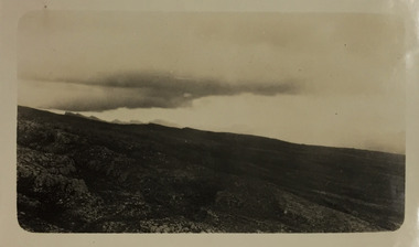
Henry Beater Christian (1886-1962) , was a descendant of one of the earliest settler families in Kew. Employed at the Kew Asylum as a 'public servant', he was a skilled amateur photographer, photographing numerous scenes in Kew and on his travels around Victoria. The majority of his photographs date from 1916 to 1929. His finest photographs are housed in two photograph albums. Digital copy of a photograph from page 14 of the 47-page photograph album containing 261 gelatinous silver images, loaned by Diane Washfold with permission given to digitise and hold a copy in our collection. The first and last pages in the album document the Yarra River at Studley Park and at Kew. The remainder of the album includes photographs of walking and car tours in rural Victoria including 'wilderness' areas in the Grampians, Gippsland and the High Country. Six album pages document a camping trip by Henry Christian to the Grampians in September 1924. The photos include pictures of lookouts, and natural features including rock faces and waterfalls, as well as his camp site. This photo is a distant view of the horizon as clouds gather."Grampians"henry beater christian (1886-1962), landscape photography, christian-washfold collection, photograph albums, grampians, gariwerd -
 Kew Historical Society Inc
Photograph - Grampians, 1924
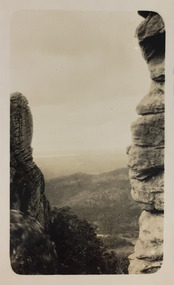
Henry Beater Christian (1886-1962) , was a descendant of one of the earliest settler families in Kew. Employed at the Kew Asylum as a 'public servant', he was a skilled amateur photographer, photographing numerous scenes in Kew and on his travels around Victoria. The majority of his photographs date from 1916 to 1929. His finest photographs are housed in two photograph albums. Digital copy of a photograph from page 14 of the 47-page photograph album containing 261 gelatinous silver images, loaned by Diane Washfold with permission given to digitise and hold a copy in our collection. The first and last pages in the album document the Yarra River at Studley Park and at Kew. The remainder of the album includes photographs of walking and car tours in rural Victoria including 'wilderness' areas in the Grampians, Gippsland and the High Country. Six album pages document a camping trip by Henry Christian to the Grampians in September 1924. The photos include pictures of lookouts, and natural features including rock faces and waterfalls, as well as his camp site. This photo is a distant view of the horizon between cliff faces."Grampians"henry beater christian (1886-1962), landscape photography, christian-washfold collection, photograph albums, grampians, gariwerd -
 Kew Historical Society Inc
Photograph - Grampians, 1924
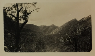
Henry Beater Christian (1886-1962) , was a descendant of one of the earliest settler families in Kew. Employed at the Kew Asylum as a 'public servant', he was a skilled amateur photographer, photographing numerous scenes in Kew and on his travels around Victoria. The majority of his photographs date from 1916 to 1929. His finest photographs are housed in two photograph albums. Digital copy of a photograph from page 15 of the 47-page photograph album containing 261 gelatinous silver images, loaned by Diane Washfold with permission given to digitise and hold a copy in our collection. The first and last pages in the album document the Yarra River at Studley Park and at Kew. The remainder of the album includes photographs of walking and car tours in rural Victoria including 'wilderness' areas in the Grampians, Gippsland and the High Country. Six album pages document a camping trip by Henry Christian to the Grampians in September 1924. The photos include pictures of lookouts, and natural features including rock faces and waterfalls, as well as his camp site. This photo is a long distance view of the mountains with trees framing the picture in the foreground. "Grampians"henry beater christian (1886-1962), landscape photography, christian-washfold collection, photograph albums, grampians, mt victory, gariwerd -
 Kew Historical Society Inc
Photograph - Demolishing the Zig-Zag Bridge, 1929
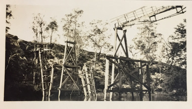
Henry Beater Christian (1886-1962) , was a descendant of one of the earliest settler families in Kew. Employed at the Kew Asylum as a 'public servant', he was a skilled amateur photographer, photographing numerous scenes in Kew and on his travels around Victoria. The majority of his photographs date from 1916 to 1929. His finest photographs are housed in two photograph albums. Rare photograph of the demolition of the Zig-Zag Bridge linking the two asylums on either side of the Yarra River.Digital copy of a photograph from page 16 of the 47-page photograph album containing 261 gelatinous silver images, loaned by Diane Washfold with permission given to digitise and hold a copy in our collection. The Zig-Zag Bridge linked the grounds of the Yarra Bend and Kew Asylums. The wooden bridge was constructed in the 1870s and lasted through numerous floods until its destruction in 1929. A horizontal structure, the walkway was reached via a wooden staircase on the Kew bank of the river. The steps were required due to the different levels of the banks on this stretch of the river. This is a closeup view of the bridge showing the level of destruction caused by the initial damage from the flood and subsequent dismantling of the horizontal struts and walkway, prior to to its destruction by fire."Demolishing Zig-Zag / 6. 1929"henry beater christian (1886-1962), landscape photography, kew (vic.) — yarra river, christian-washfold collection, photograph albums, zig-zag bridge -
 Kew Historical Society Inc
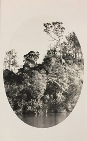
Photograph - Tambo River, 1926
Henry Beater Christian (1886-1962) , was a descendant of one of the earliest settler families in Kew. Employed at the Kew Asylum as a 'public servant', he was a skilled amateur photographer, photographing numerous scenes in Kew and on his travels around Victoria. The majority of his photographs date from 1916 to 1929. His finest photographs are housed in two photograph albums. Digital copy of a photograph from page 31 of the 47-page photograph album containing 261 gelatinous silver images, loaned by Diane Washfold with permission given to digitise and hold a copy in our collection. John Chapman has written in 'Bushwalking Clubs - A Brief History', about the establishment in Victoria of the first bushwalking club in 1888, and the popularisation of bushwalking during the interwar period. Henry Christian's 'walks' appear to have been undertaken solely or with a companion/s. This black and white photo is part of a group of six photos taken on an 18 kilometre walking trip between Bruthen and Swan Reach in East Gippsland in 1926. The route of the walk followed the Tambo River. The photographer has focussed the view using an oval frame during the development process."BRUTHEN TO SWAN REACH 1926"henry beater christian (1886-1962), landscape photography, christian-washfold collection, photograph albums, bushwalking, bruthen, swan reach, tambo river, east gippsland -
 Kew Historical Society Inc
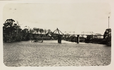
Photograph - Bridge over the Tambo River, 1926
Henry Beater Christian (1886-1962) , was a descendant of one of the earliest settler families in Kew. Employed at the Kew Asylum as a 'public servant', he was a skilled amateur photographer, photographing numerous scenes in Kew and on his travels around Victoria. The majority of his photographs date from 1916 to 1929. His finest photographs are housed in two photograph albums. Digital copy of a photograph from page 31 of the 47-page photograph album containing 261 gelatinous silver images, loaned by Diane Washfold with permission given to digitise and hold a copy in our collection. John Chapman has written in 'Bushwalking Clubs - A Brief History', about the establishment in Victoria of the first bushwalking club in 1888, and the popularisation of bushwalking during the interwar period. Henry Christian's 'walks' appear to have been undertaken solely or with a companion/s. This black and white photo is part of a group of six photos taken on an 18 kilometre walking trip between Bruthen and Swan Reach in East Gippsland in 1926. The route of the walk followed the Tambo River. The photographer has focussed the view on a ruined bridge, presumably caused by a flood, crossing the river. Sections of the left hand pier and span can be seen in the river."BRUTHEN TO SWAN REACH 1926"henry beater christian (1886-1962), landscape photography, christian-washfold collection, photograph albums, bushwalking, bruthen, swan reach, tambo river, east gippsland -
 Kew Historical Society Inc
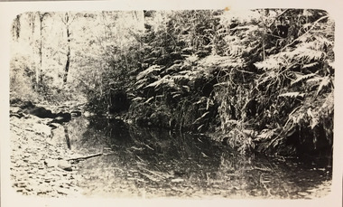
Photograph - Small creek between Bruthen and Swan Reach, 1926
Henry Beater Christian (1886-1962) , was a descendant of one of the earliest settler families in Kew. Employed at the Kew Asylum as a 'public servant', he was a skilled amateur photographer, photographing numerous scenes in Kew and on his travels around Victoria. The majority of his photographs date from 1916 to 1929. His finest photographs are housed in two photograph albums. Digital copy of a photograph from page 31 of the 47-page photograph album containing 261 gelatinous silver images, loaned by Diane Washfold with permission given to digitise and hold a copy in our collection. John Chapman has written in 'Bushwalking Clubs - A Brief History', about the establishment in Victoria of the first bushwalking club in 1888, and the popularisation of bushwalking during the interwar period. Henry Christian's 'walks' appear to have been undertaken solely or with a companion/s. This black and white photo is part of a group of six photos taken on an 18 kilometre walking trip between Bruthen and Swan Reach in East Gippsland in 1926. The route of the walk followed the Tambo River. The photographer has focussed the view on a small creek between the two towns."BRUTHEN TO SWAN REACH 1926"henry beater christian (1886-1962), landscape photography, christian-washfold collection, photograph albums, bushwalking, bruthen, swan reach, tambo river, east gippsland -
 Kew Historical Society Inc
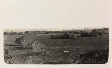
Photograph - Farmland, near or between Bruthen and Swan Reach, 1926
Henry Beater Christian (1886-1962) , was a descendant of one of the earliest settler families in Kew. Employed at the Kew Asylum as a 'public servant', he was a skilled amateur photographer, photographing numerous scenes in Kew and on his travels around Victoria. The majority of his photographs date from 1916 to 1929. His finest photographs are housed in two photograph albums. Digital copy of a photograph from page 31 of the 47-page photograph album containing 261 gelatinous silver images, loaned by Diane Washfold with permission given to digitise and hold a copy in our collection. John Chapman has written in 'Bushwalking Clubs - A Brief History', about the establishment in Victoria of the first bushwalking club in 1888, and the popularisation of bushwalking during the interwar period. Henry Christian's 'walks' appear to have been undertaken solely or with a companion/s. This black and white photo is part of a group of six photos taken on an 18 kilometre walking trip between Bruthen and Swan Reach in East Gippsland in 1926. The route of the walk followed the Tambo River. The photographer focusses the camera view on distant farmland near or between either of the two towns."BRUTHEN TO SWAN REACH 1926"henry beater christian (1886-1962), landscape photography, christian-washfold collection, photograph albums, bushwalking, bruthen, swan reach, tambo river, east gippsland -
 Kew Historical Society Inc
Photograph - Farmland, near Bruthen or Swan Reach, 1926
Henry Beater Christian (1886-1962) , was a descendant of one of the earliest settler families in Kew. Employed at the Kew Asylum as a 'public servant', he was a skilled amateur photographer, photographing numerous scenes in Kew and on his travels around Victoria. The majority of his photographs date from 1916 to 1929. His finest photographs are housed in two photograph albums. Digital copy of a photograph from page 31 of the 47-page photograph album containing 261 gelatinous silver images, loaned by Diane Washfold with permission given to digitise and hold a copy in our collection. John Chapman has written in 'Bushwalking Clubs - A Brief History', about the establishment in Victoria of the first bushwalking club in 1888, and the popularisation of bushwalking during the interwar period. Henry Christian's 'walks' appear to have been undertaken solely or with a companion/s. This black and white photo is part of a group of six photos taken on an 18 kilometre walking trip between Bruthen and Swan Reach in East Gippsland in 1926. The route of the walk followed the Tambo River. The photographer focusses the camera view on the township in the distance with farms in the foreground."BRUTHEN TO SWAN REACH 1926"henry beater christian (1886-1962), landscape photography, christian-washfold collection, photograph albums, bushwalking, bruthen, swan reach, tambo river, east gippsland -
![Junction of the River Watt and Contentment Creek / [by] Nicholas Caire, circa 1876](/media/collectors/550653872162f11fb04854aa/items/57760437d0cdd10a5c49fc3e/item-media/57760510d0cdd10a5c4a8f9c/item-fit-380x285.jpg) Kew Historical Society Inc
Kew Historical Society IncPhotograph, Anglo-Australasian Photographic Company, Junction of the River Watt and Contentment Creek, c. 1876
Nicholas Caire was born on Guernsey in the Channel Islands in 1837. He arrived in Adelaide with his parents in about 1860. In 1867, following photographic journeys in Gippsland, he opened a studio in Adelaide. From 1870 to 1876 he lived and worked in Talbot in Central Victoria. In 1876 he purchased T. F. Chuck's studios in the Royal Arcade Melbourne. In 1885, following the introduction of dry plate photography, he began a series of landscape series, which were commercially successful. As a photographer, he travelled extensively through Victoria, photographing places few of his contemporaries had previously seen. He died in 1918. Reference: Jack Cato, 'Caire, Nicholas John (1837–1918)', Australian Dictionary of Biography.An original, rare photograph from the series 'Views of Victoria: General Series' by the photographer, Nicholas Caire (1837-1918). The series of 60 photographs that comprise the series was issued c. 1876 and reinforced a neo-Romantic view of the Australian landscape to which a growing nationalist movement would respond. Nicholas Caire was active as a photographer in Australia from 1858 until his death in 1918. His vision of the Australian bush and pioneer life had a counterpart in the works of Henry Lawson and other nationalist poets, authors and painters.Albumen Silver Photograph, mounted on Board. printed in ink on support l.c.: JUNCTION OF THE RIVER WATT AND CONTENTMENT CREEK. / COPYRIGHT REGISTERED. printed in ink on support reverse c.: VIEWS OF VICTORIA. / (GENERAL SERIES.) / No. 1. / JUNCTION OF THE RIVER WATT AND CONTENTMENT CREEK. / This scene is situated about two miles to the westward of Fernshawe, a small but extremely romantic township. / The river, at this juncture, is crossed by a fallen tree, as may be seen in the illustration. The track which is seen on / the opposite side of the river leads to the summit of Mt. Munda (3,500 feet high), 4 miles distant, from which place / visitors can see the Australian Alps, in all their mighty grandeur, stretching for hundreds of miles on either side, / and, as far as the eye can reach, impressing a beholder with the appropriateness of their title, being that of the Great Dividing Range. printed in ink on support reverse l.c.l.: J.W. FORBES, Agent, printed in ink on support reverse l.c.: ANGLO-AUSTRALASIAN PHOTOGRAPHIC COMPANY, MELBOURNE. printed in ink on support reverse l.c.r.: 10 Temple Court, Collins Street West.nicholas caire, views of victoria - general series, landscape photography -
![Junction of the Rivers Yarra and Watt, Near Healesville / [by] Nicholas Caire, circa 1876](/media/collectors/550653872162f11fb04854aa/items/577740e5d0cdd10a5c0de011/item-media/57774153d0cdd10a5c0e0662/item-fit-380x285.jpg) Kew Historical Society Inc
Kew Historical Society IncPhotograph, Anglo-Australasian Photographic Company, Junction of the Rivers Yarra and Watt, Near Healesville, c. 1876
Nicholas Caire was born on Guernsey in the Channel Islands in 1837. He arrived in Adelaide with his parents in about 1860. In 1867, following photographic journeys in Gippsland, he opened a studio in Adelaide. From 1870 to 1876 he lived and worked in Talbot in Central Victoria. In 1876 he purchased T. F. Chuck's studios in the Royal Arcade Melbourne. In 1885, following the introduction of dry plate photography, he began a series of landscape series, which were commercially successful. As a photographer, he travelled extensively through Victoria, photographing places few of his contemporaries had previously seen. He died in 1918. Reference: Jack Cato, 'Caire, Nicholas John (1837–1918)', Australian Dictionary of Biography.An original, rare photograph from the series 'Views of Victoria: General Series' by the photographer, Nicholas Caire (1837-1918). The series of 60 photographs that comprise the series was issued c. 1876 and reinforced a neo-Romantic view of the Australian landscape to which a growing nationalist movement would respond. Nicholas Caire was active as a photographer in Australia from 1858 until his death in 1918. His vision of the Australian bush and pioneer life had a counterpart in the works of Henry Lawson and other nationalist poets, authors and painters.Albumen Silver Photograph, mounted on Board.printed in ink on support l.c.: JUNCTION OF THE RIVERS YARRA AND WATT, NEAR HEALESVILLE. / COPYRIGHT REGISTERED. printed in ink on support reverse c.: VIEWS OF VICTORIA. / (GENERAL SERIES.) / No. 3. / JUNCTION OF THE RIVERS YARRA AND WATT, NEAR HEALESVILLE / The junction is situated about 3 miles from Healesville, and 35 miles from the mouth of the Yarra. The souces / of the Watt are to be found at the head of the Black Spur, and, being fed by a number of creeks and springs, its / waters gain considerable force for several miles before joining those of the Yarra. The "Old Bridge," at the junction, / is the name given to this crossing-place, which has been partly swept away by late floods. The depth of the Yarra here / is from 15 to 20 feet; that of the Watt, about 10 feet. printed in ink on support reverse l.c.l.: J.W. FORBES, Agent, printed in ink on support reverse l.c.: ANGLO-AUSTRALASIAN PHOTOGRAPHIC COMPANY, MELBOURNE. printed in ink on support reverse l.c.r.: 10 Temple Court, Collins Street West.nicholas caire (1837-1918), yarra river, watt river, bridge, wooden bridge, healesville -
![State School, Fernshawe / [by] Nicholas Caire, circa 1876](/media/collectors/550653872162f11fb04854aa/items/5777443dd0cdd10a5c0fa4c9/item-media/57774498d0cdd10a5c0fd7bf/item-fit-380x285.jpg) Kew Historical Society Inc
Kew Historical Society IncPhotograph, State School, Fernshawe, c. 1876
Nicholas Caire was born on Guernsey in the Channel Islands in 1837. He arrived in Adelaide with his parents in about 1860. In 1867, following photographic journeys in Gippsland, he opened a studio in Adelaide. From 1870 to 1876 he lived and worked in Talbot in Central Victoria. In 1876 he purchased T. F. Chuck's studios in the Royal Arcade Melbourne. In 1885, following the introduction of dry plate photography, he began a series of landscape series, which were commercially successful. As a photographer, he travelled extensively through Victoria, photographing places few of his contemporaries had previously seen. He died in 1918. Reference: Jack Cato, 'Caire, Nicholas John (1837–1918)', Australian Dictionary of Biography.An original, rare photograph from the series 'Views of Victoria: General Series' by the photographer, Nicholas Caire (1837-1918). The series of 60 photographs that comprise the series was issued c. 1876 and reinforced a neo-Romantic view of the Australian landscape to which a growing nationalist movement would respond. Nicholas Caire was active as a photographer in Australia from 1858 until his death in 1918. His vision of the Australian bush and pioneer life had a counterpart in the works of Henry Lawson and other nationalist poets, authors and painters.Albumen Silver Photograph mounted on boardprinted in ink on support l.c.: STATE SCHOOL, FERNSHAWE. / COPYRIGHT REGISTERED. printed in ink on support reverse c.: VIEWS OF VICTORIA. / (GENERAL SERIES.) / No. 5. / STATE SCHOOL, FERNSHAWE. / This educational institution occupies one of the most romantic situations of any of the State Schools in Victoria. / On either side of it runs a river and a creek, whilst immediately surrounding it are a great many large fern trees. / The background comprises many giants of the forest. In the centre of the picture stands a stump, about 60 feet / high, which has evidently been struck by lightning. The neighbourhood, not being a very populous one, furnishes / but 30 children for educational training. printed in ink on support reverse l.c.l.: J.W. FORBES, Agent, printed in ink on support reverse l.c.: ANGLO-AUSTRALASIAN PHOTOGRAPHIC COMPANY, MELBOURNE printed in ink on support reverse l.c.r.: 10 Temple Court, Collins Street West.nicholas caire (1837-1918), landscape photography -
![View of the River Murray, near Echuca, showing the Railway Wharf with steamers unloading / [by] Nicholas Caire, circa 1876](/media/collectors/550653872162f11fb04854aa/items/57774776d0cdd10a5c111b2d/item-media/57774888d0cdd10a5c11c099/item-fit-380x285.jpg) Kew Historical Society Inc
Kew Historical Society IncPhotograph, Anglo-Australasian Photographic Company, View of the River Murray, near Echuca, showing the Railway Wharf with steamers unloading, c. 1876
... View of the River Murray, near Echuca, showing the Railway...printed in ink on support l.c.: VIEW ON THE RIVER MURRAY... echuca printed in ink on support l.c.: VIEW ON THE RIVER MURRAY ...Nicholas Caire was born on Guernsey in the Channel Islands in 1837. He arrived in Adelaide with his parents in about 1860. In 1867, following photographic journeys in Gippsland, he opened a studio in Adelaide. From 1870 to 1876 he lived and worked in Talbot in Central Victoria. In 1876 he purchased T. F. Chuck's studios in the Royal Arcade Melbourne. In 1885, following the introduction of dry plate photography, he began a series of landscape series, which were commercially successful. As a photographer, he travelled extensively through Victoria, photographing places few of his contemporaries had previously seen. He died in 1918. Reference: Jack Cato, 'Caire, Nicholas John (1837–1918)', Australian Dictionary of Biography.An original, rare photograph from the series 'Views of Victoria: General Series' by the photographer, Nicholas Caire (1837-1918). The series of 60 photographs that comprise the series was issued c. 1876 and reinforced a neo-Romantic view of the Australian landscape to which a growing nationalist movement would respond. Nicholas Caire was active as a photographer in Australia from 1858 until his death in 1918. His vision of the Australian bush and pioneer life had a counterpart in the works of Henry Lawson and other nationalist poets, authors and painters.albumen silver photograph on boardprinted in ink on support l.c.: VIEW ON THE RIVER MURRAY, NEAR ECHUCA, SHOWING THE RAILWAY WHARF WITH STEAMERS UNLOADING. / COPYRIGHT REGISTERED. printed in ink on support reverse c.: VIEWS OF VICTORIA. / (GENERAL SERIES.) / No. 7. / VIEW ON THE RIVER MURRAY, NEAR ECHUCA, SHOWING THE RAILWAY WHARF WITH STEAMERS UNLOADING. / The rapidly increasing traffic on the River Murray, with wool, timber, and other colonial produce, has called / into requisition no less than 400 steamers and over 1000 barges. To meet this growing emergency the Victorian / Government has expended several thousand pounds in the erection of a Railway Wharf which during the wool- / season presents a very busy scene, the crowded steamers laden with precious clip taxing to the utmost the / powers of the Railway Department in the process of unloading. The River here is about a quarter of a mile wide, / and is from 60 to 70 feet deep. printed in ink on support reverse l.c.l.: J.W. FORBES, Agent, printed in ink on support reverse l.c.: ANGLO-AUSTRALASIAN PHOTOGRAPHIC COMPANY, MELBOURNE. printed in ink on support reverse l.c.r.: 10 Temple Court, Collins Street West.nicholas caire (1837-1918), landscape photography, river murray, echuca -
![Scene near Corranderrk Station / [by] Nicholas Caire, circa 1876](/media/collectors/550653872162f11fb04854aa/items/57774ae0d0cdd10a5c12f2d7/item-media/57774b61d0cdd10a5c132dac/item-fit-380x285.jpg) Kew Historical Society Inc
Kew Historical Society IncPhotograph, Anglo-Australasian Photographic Company, Scene near Corranderrk Station, c. 1876
Nicholas Caire was born on Guernsey in the Channel Islands in 1837. He arrived in Adelaide with his parents in about 1860. In 1867, following photographic journeys in Gippsland, he opened a studio in Adelaide. From 1870 to 1876 he lived and worked in Talbot in Central Victoria. In 1876 he purchased T. F. Chuck's studios in the Royal Arcade Melbourne. In 1885, following the introduction of dry plate photography, he began a series of landscape series, which were commercially successful. As a photographer, he travelled extensively through Victoria, photographing places few of his contemporaries had previously seen. He died in 1918. Reference: Jack Cato, 'Caire, Nicholas John (1837–1918)', Australian Dictionary of Biography. The 1860s marked the beginning of the era of reserves and missions. Six Aboriginal reserves were established during the 1860s. These were under the control of the Board for the Protection of Aborigines. Four were Christian missions receiving government aid. These were Lake Tyers (Anglican) and Ramahyuck (Presbyterian/Moravian) in eastern Victoria for the Gunai/Kurnai clans; Ebenezer (Moravian) in north-west Victoria for the clans of the Wimmera and Lower Murray; and Lake Condah (Anglican) in south-west Victoria. The other two were secular government controlled reserves: Framlingham which, like Lake Condah, was established for the Mara-speaking Gunditjmara and Kirrae-wurrung people of south-west Victoria; and Coranderrk, located about 60 kilometres north-east of Melbourne, for the Kulin clans of central Victoria. In 1863, after a period of devastation to the Kulin people, Coranderrk was established at the junction of the Yarra River and Badger Creek. Reference: http://coranderrk.com/, accessed 24 December 2016An original, rare photograph from the series 'Views of Victoria: General Series' by the photographer, Nicholas Caire (1837-1918). The series of 60 photographs that comprise the series was issued c. 1876 and reinforced a neo-Romantic view of the Australian landscape to which a growing nationalist movement would respond. Nicholas Caire was active as a photographer in Australia from 1858 until his death in 1918. His vision of the Australian bush and pioneer life had a counterpart in the works of Henry Lawson and other nationalist poets, authors and painters.Albumen silver photograph mounted on boardprinted in ink on support l.c.: SCENE NEAR "CORRANDERRK" STATION. / COPYRIGHT REGISTERED. printed in ink on support reverse c.: VIEWS OF VICTORIA. / (GENERAL SERIES.) / No. 9. / SCENE NEAR "CORRANDERRK" STATION. / This scene was taken from the hill near Rourke's Bridge, on the Healesville Road, and displays in the foreground / the River Yarra. The roadway which is seen in the mid-distance has lately been constructed by the Government, / as the old tracks which formerly existed, were liable to be swamped by the periodical overflowing of the River. Mount / Ridell can be seen in the extreme distance immediately behind the roadway. / Corranderrk is the local habitation / for the natives of this district, and is situated on the right hand side of the picture, about a mile and a half / from the roadway. printed in ink on support reverse l.c.l.: J.W. FORBES, Agent, printed in ink on support reverse l.c.: ANGLO-AUSTRALASIAN PHOTOGRAPHIC COMPANY, MELBOURNE. printed in ink on support reverse l.c.r.: 10 Temple Court, Collins Street West.nicholas caire (1837-1918), coranderrk aboriginal station, aborigine, yarra river, badger creek, first peoples, aboriginal and torres straight islander -
![Scene on the Yarra, near Rourke's Bridge / [by] Nicholas Caire, circa 1876](/media/collectors/550653872162f11fb04854aa/items/5777571cd0cdd10a5c191a9c/item-media/57775788d0cdd10a5c193e0d/item-fit-380x285.jpg) Kew Historical Society Inc
Kew Historical Society IncPhotograph, Anglo-Australasian Photographic Company, Scene on the Yarra, near Rourke's Bridge, c. 1876
Nicholas Caire was born on Guernsey in the Channel Islands in 1837. He arrived in Adelaide with his parents in about 1860. In 1867, following photographic journeys in Gippsland, he opened a studio in Adelaide. From 1870 to 1876 he lived and worked in Talbot in Central Victoria. In 1876 he purchased T. F. Chuck's studios in the Royal Arcade Melbourne. In 1885, following the introduction of dry plate photography, he began a series of landscape series, which were commercially successful. As a photographer, he travelled extensively through Victoria, photographing places few of his contemporaries had previously seen. He died in 1918. Reference: Jack Cato, 'Caire, Nicholas John (1837–1918)', Australian Dictionary of BiographyAn original, rare photograph from the series 'Views of Victoria: General Series' by the photographer, Nicholas Caire (1837-1918). The series of 60 photographs that comprise the series was issued c. 1876 and reinforced a neo-Romantic view of the Australian landscape to which a growing nationalist movement would respond. Nicholas Caire was active as a photographer in Australia from 1858 until his death in 1918. His vision of the Australian bush and pioneer life had a counterpart in the works of Henry Lawson and other nationalist poets, authors and painters.Albumen silver photograph mounted on boardprinted in ink on support l.c.: SCENE ON THE YARRA, NEAR ROURKE'S BRIDGE. / COPYRIGHT REGISTERED. printed in ink on support reverse c.: VIEWS OF VICTORIA. / (GENERAL SERIES.) / No. 16. / SCENE ON THE YARRA, NEAR ROURKE'S BRIDGE. / The subject of the present illustration represents the New Bridge crossing the River Yarra on the road from / St. Huberts to the Native Station at Corranderrk, and to the township at Healesville. The river at this place abounds / with fish of a large description, which are caught by the Natives, frequently in considerable quantitities. printed in ink on support reverse l.c.l.: J.W. FORBES, Agent, printed in ink on support reverse l.c.: ANGLO-AUSTRALASIAN PHOTOGRAPHIC COMPANY, MELBOURNE. printed in ink on support reverse l.c.r.: 10 Temple Court, Collins Street West.nicholas caire (1837-1918), landscape photography - victoria -
![Fern Terrace, on the River Watt, near Mount Munday / [by] Nicholas Caire, circa 1876](/media/collectors/550653872162f11fb04854aa/items/57775865d0cdd10a5c19a296/item-media/57775986d0cdd10a5c1a3308/item-fit-380x285.jpg) Kew Historical Society Inc
Kew Historical Society IncPhotograph, Anglo-Australasian Photographic Company, Fern Terrace, on the River Watt, near Mount Munday, c. 1876
Nicholas Caire was born on Guernsey in the Channel Islands in 1837. He arrived in Adelaide with his parents in about 1860. In 1867, following photographic journeys in Gippsland, he opened a studio in Adelaide. From 1870 to 1876 he lived and worked in Talbot in Central Victoria. In 1876 he purchased T. F. Chuck's studios in the Royal Arcade Melbourne. In 1885, following the introduction of dry plate photography, he began a series of landscape series, which were commercially successful. As a photographer, he travelled extensively through Victoria, photographing places few of his contemporaries had previously seen. He died in 1918. Reference: Jack Cato, 'Caire, Nicholas John (1837–1918)', Australian Dictionary of BiographyAn original, rare photograph from the series 'Views of Victoria: General Series' by the photographer, Nicholas Caire (1837-1918). The series of 60 photographs that comprise the series was issued c. 1876 and reinforced a neo-Romantic view of the Australian landscape to which a growing nationalist movement would respond. Nicholas Caire was active as a photographer in Australia from 1858 until his death in 1918. His vision of the Australian bush and pioneer life had a counterpart in the works of Henry Lawson and other nationalist poets, authors and painters.Albumen silver photograph mounted on boardprinted in ink on support l.c.: FERN TERRACE, ON THE RIVER WATT, NEAR MOUNT MUNDAY. / COPYRIGHT REGISTERED. printed in ink on support reverse c.: VIEWS OF VICTORIA. / (GENERAL SERIES.) / No. 17. / FERN TERRACE, ON THE RIVER WATT, NEAR MOUNT MUNDAY. / Of the various Rivers which exist in the Colony of Victoria, the River Watt (though a small one, and to some / extent unimportant) may be said to contain the most charming as well as the greatest variety of romantic scenery. / The scene of the present issue is perhaps the most unique of its character to be found in any of the Colonies. printed in ink on support reverse l.c.l.: J.W. FORBES, Agent, printed in ink on support reverse l.c.: ANGLO-AUSTRALASIAN PHOTOGRAPHIC COMPANY, MELBOURNE. printed in ink on support reverse l.c.r.: 10 Temple Court, Collins Street West.nicholas caire (1837-1918), landscape photography - victoria -
![The Old Crossing-Place at Fernshawe / [by] Nicholas Caire, circa 1876](/media/collectors/550653872162f11fb04854aa/items/577b49a5d0cdd10948c74db4/item-media/577b4a0bd0cdd10948c78ebb/item-fit-380x285.jpg) Kew Historical Society Inc
Kew Historical Society IncPhotograph, Anglo-Australasian Photographic Company, The Old Crossing-Place at Fernshawe, c. 1876
Nicholas Caire was born on Guernsey in the Channel Islands in 1837. He arrived in Adelaide with his parents in about 1860. In 1867, following photographic journeys in Gippsland, he opened a studio in Adelaide. From 1870 to 1876 he lived and worked in Talbot in Central Victoria. In 1876 he purchased T. F. Chuck's studios in the Royal Arcade Melbourne. In 1885, following the introduction of dry plate photography, he began a series of landscape series, which were commercially successful. As a photographer, he travelled extensively through Victoria, photographing places few of his contemporaries had previously seen. He died in 1918. Reference: Jack Cato, 'Caire, Nicholas John (1837–1918)', Australian Dictionary of Biography.An original, rare photograph from the series 'Views of Victoria: General Series' by the photographer, Nicholas Caire (1837-1918). The series of 60 photographs that comprise the series was issued c. 1876 and reinforced a neo-Romantic view of the Australian landscape to which a growing nationalist movement would respond. Nicholas Caire was active as a photographer in Australia from 1858 until his death in 1918. His vision of the Australian bush and pioneer life had a counterpart in the works of Henry Lawson and other nationalist poets, authors and painters.Albumen silver photograph mounted on boardInscription on reverse: ‘In the distance among the foliage can be seen the New Bridge across the River Watt. Previous to its erection, the only means of crossing over to the township was across the fallen trees, which are of prodigious dimensions. The River, as may be seen, is very rapid, and, though shallow, it contains a great quantity of fish of a somewhat moderate size.’nicholas caire (1837-1918), landscape photography -
![Scene Near the Yarra Flats / [by] Nicholas Caire, circa 1876](/media/collectors/550653872162f11fb04854aa/items/577b4ae3d0cdd10948c7f0b6/item-media/577b4b3fd0cdd10948c81c16/item-fit-380x285.jpg) Kew Historical Society Inc
Kew Historical Society IncPhotograph, Anglo-Australasian Photographic Company, Scene Near the Yarra Flats, c. 1876
Nicholas Caire was born on Guernsey in the Channel Islands in 1837. He arrived in Adelaide with his parents in about 1860. In 1867, following photographic journeys in Gippsland, he opened a studio in Adelaide. From 1870 to 1876 he lived and worked in Talbot in Central Victoria. In 1876 he purchased T. F. Chuck's studios in the Royal Arcade Melbourne. In 1885, following the introduction of dry plate photography, he began a series of landscape series, which were commercially successful. As a photographer, he travelled extensively through Victoria, photographing places few of his contemporaries had previously seen. He died in 1918. Reference: Jack Cato, 'Caire, Nicholas John (1837–1918)', Australian Dictionary of Biography.An original, rare photograph from the series 'Views of Victoria: General Series' by the photographer, Nicholas Caire (1837-1918). The series of 60 photographs that comprise the series was issued c. 1876 and reinforced a neo-Romantic view of the Australian landscape to which a growing nationalist movement would respond. Nicholas Caire was active as a photographer in Australia from 1858 until his death in 1918. His vision of the Australian bush and pioneer life had a counterpart in the works of Henry Lawson and other nationalist poets, authors and painters.Views of Victoria (General Series) No.21 / ‘Scene near the Yarra Flats’ / Albumen silver photograph mounted on board.Inscription on reverse: ‘The scenery in the vicinity of the Yarra Flats is of a very varied character. In some places the River winds its way through flat open country, with scarcely a shrub on its banks; and in others the scenery is of the wildest description. The stream being impeded in its course by fallen timber, is not so rapid here as at other places. The present illustration is a characteristic one of the above place.’nicholas caire, australia - landscape photography -
![Fern Bridge Gully, Black Spur / [by] Nicholas Caire, circa 1876](/media/collectors/550653872162f11fb04854aa/items/577b4c16d0cdd10948c8afab/item-media/577b4c75d0cdd10948c8ebe0/item-fit-380x285.jpg) Kew Historical Society Inc
Kew Historical Society IncPhotograph, Anglo-Australasian Photographic Company, Fern Bridge Gully, Black Spur, c. 1876
... of the River Watt.’ Views of Victoria (General Series), No.22 / ‘Fern ...Nicholas Caire was born on Guernsey in the Channel Islands in 1837. He arrived in Adelaide with his parents in about 1860. In 1867, following photographic journeys in Gippsland, he opened a studio in Adelaide. From 1870 to 1876 he lived and worked in Talbot in Central Victoria. In 1876 he purchased T. F. Chuck's studios in the Royal Arcade Melbourne. In 1885, following the introduction of dry plate photography, he began a series of landscape series, which were commercially successful. As a photographer, he travelled extensively through Victoria, photographing places few of his contemporaries had previously seen. He died in 1918. Reference: Jack Cato, 'Caire, Nicholas John (1837–1918)', Australian Dictionary of Biography.An original, rare photograph from the series 'Views of Victoria: General Series' by the photographer, Nicholas Caire (1837-1918). The series of 60 photographs that comprise the series was issued c. 1876 and reinforced a neo-Romantic view of the Australian landscape to which a growing nationalist movement would respond. Nicholas Caire was active as a photographer in Australia from 1858 until his death in 1918. His vision of the Australian bush and pioneer life had a counterpart in the works of Henry Lawson and other nationalist poets, authors and painters.Views of Victoria (General Series), No.22 / ‘Fern Bridge Gully, Black Spur’ / Albumen silver photograph mounted on boardInscription on reverse: 'Fern Bridge Gully is situated near the summit of the Black Spur, about two miles from Fernshawe. Here the foliage is exceedingly dense, so much so as to exclude daylight in many places. This stream has derived its name from the fact of the Bridge having been constructed of large massive fern tree. The stream which flows beneath the Bridge is one of the sources of the River Watt.’nicholas caire (1837-1918), australia - landscape photography -
![Waterfall Scene on the Coliban River, near Elphinstone / [by] Nicholas Caire, circa 1876](/media/collectors/550653872162f11fb04854aa/items/577b4d42d0cdd10948c96acf/item-media/577b4dbfd0cdd10948c9b34f/item-fit-380x285.jpg) Kew Historical Society Inc
Kew Historical Society IncPhotograph, Anglo-Australasian Photographic Company, Waterfall Scene on the Coliban River, near Elphinstone, c. 1876
Nicholas Caire was born on Guernsey in the Channel Islands in 1837. He arrived in Adelaide with his parents in about 1860. In 1867, following photographic journeys in Gippsland, he opened a studio in Adelaide. From 1870 to 1876 he lived and worked in Talbot in Central Victoria. In 1876 he purchased T. F. Chuck's studios in the Royal Arcade Melbourne. In 1885, following the introduction of dry plate photography, he began a series of landscape series, which were commercially successful. As a photographer, he travelled extensively through Victoria, photographing places few of his contemporaries had previously seen. He died in 1918. Reference: Jack Cato, 'Caire, Nicholas John (1837–1918)', Australian Dictionary of Biography.An original, rare photograph from the series 'Views of Victoria: General Series' by the photographer, Nicholas Caire (1837-1918). The series of 60 photographs that comprise the series was issued c. 1876 and reinforced a neo-Romantic view of the Australian landscape to which a growing nationalist movement would respond. Nicholas Caire was active as a photographer in Australia from 1858 until his death in 1918. His vision of the Australian bush and pioneer life had a counterpart in the works of Henry Lawson and other nationalist poets, authors and painters.Views of Victoria (General Series) No.23 / ‘Waterfall scene on the Coliban River, near Elphinstone’ / Albumen silver photograph mounted on boardOn reverse: ‘The scene this illustration presents is but one of the many that exist along the course of this shallow River, which, like its parent the Campaspe, abounds with rocky and romantic scenery. The fall of the River at this place is over one hundred feet, but is broken by a long course of rocks to the lower bed; the actual fall as seen is about forty feet. The Coliban, though only a branch of the Campaspe, derives its name from the fact that its course runs through the Coliban Park. Gold is found in considerable quantities along the banks and in the stream, but at the present time these diggings are worked only by Chinamen.’nicholas caire (1837-1918), australia - landscape photography -
![Scene on the River Campaspe / [by] Nicholas Caire, circa 1876](/media/collectors/550653872162f11fb04854aa/items/577b50b0d0cdd10948cb4cf6/item-media/577b51d2d0cdd10948cbedda/item-fit-380x285.jpg) Kew Historical Society Inc
Kew Historical Society IncPhotograph, Anglo-Australasian Photographic Company, Scene on the River Campaspe, c. 1876
Nicholas Caire was born on Guernsey in the Channel Islands in 1837. He arrived in Adelaide with his parents in about 1860. In 1867, following photographic journeys in Gippsland, he opened a studio in Adelaide. From 1870 to 1876 he lived and worked in Talbot in Central Victoria. In 1876 he purchased T. F. Chuck's studios in the Royal Arcade Melbourne. In 1885, following the introduction of dry plate photography, he began a series of landscape series, which were commercially successful. As a photographer, he travelled extensively through Victoria, photographing places few of his contemporaries had previously seen. He died in 1918. Reference: Jack Cato, 'Caire, Nicholas John (1837–1918)', Australian Dictionary of Biography.An original, rare photograph from the series 'Views of Victoria: General Series' by the photographer, Nicholas Caire (1837-1918). The series of 60 photographs that comprise the series was issued c. 1876 and reinforced a neo-Romantic view of the Australian landscape to which a growing nationalist movement would respond. Nicholas Caire was active as a photographer in Australia from 1858 until his death in 1918. His vision of the Australian bush and pioneer life had a counterpart in the works of Henry Lawson and other nationalist poets, authors and painters.Views of Victoria (General Series) No.25 / ‘Scene on the River Campaspe’ / Albumen silver photograph mounted on boardOn Reverse: ‘The River Campaspe flows into the River Murray, near the Town of Echuca. It is a river of considerable size, and is subject to frequent overflowing of its banks, in consequence of the low flat country through which it runs. Our illustration represents the River during one of the periodical floods, its depth being over thirty feet at the time.’nicholas caire (1837-1918), australia - landscape photography -
![Bend of the River Watt / [by] Nicholas Caire, circa 1876](/media/collectors/550653872162f11fb04854aa/items/577b52c2d0cdd10948cc9307/item-media/577b5328d0cdd10948ccc8b6/item-fit-380x285.jpg) Kew Historical Society Inc
Kew Historical Society IncPhotograph, Anglo-Australasian Photographic Company, Bend of the River Watt, c.1876
Nicholas Caire was born on Guernsey in the Channel Islands in 1837. He arrived in Adelaide with his parents in about 1860. In 1867, following photographic journeys in Gippsland, he opened a studio in Adelaide. From 1870 to 1876 he lived and worked in Talbot in Central Victoria. In 1876 he purchased T. F. Chuck's studios in the Royal Arcade Melbourne. In 1885, following the introduction of dry plate photography, he began a series of landscape series, which were commercially successful. As a photographer, he travelled extensively through Victoria, photographing places few of his contemporaries had previously seen. He died in 1918. Reference: Jack Cato, 'Caire, Nicholas John (1837–1918)', Australian Dictionary of Biography.An original, rare photograph from the series 'Views of Victoria: General Series' by the photographer, Nicholas Caire (1837-1918). The series of 60 photographs that comprise the series was issued c. 1876 and reinforced a neo-Romantic view of the Australian landscape to which a growing nationalist movement would respond. Nicholas Caire was active as a photographer in Australia from 1858 until his death in 1918. His vision of the Australian bush and pioneer life had a counterpart in the works of Henry Lawson and other nationalist poets, authors and painters.Views of Victoria (General Series) No.26 / 'Bend of the River Watt' / Albumen silver photograph mounted on boardOn Reverse: 'The present illustration represents a scene on the River Watt, and is situated in the valley between Mount Juliet and Mount Monda. The immediate neighbourhood abounds with scenery of the wildest and most romantic character. The River here is as clear as crystal, owing, no doubt, to its bed being composed of rock and pebbles. The banks on either side are studded with foliage so dense as to render access to the neighbourhood almost impracticable.’nicholas caire (1837-1918), australia - landscape photography -
![The Punt, Echuca / [by] Nicholas Caire, circa 1876](/media/collectors/550653872162f11fb04854aa/items/57825721d0cdd1176ce1789a/item-media/57825765d0cdd1176ce19829/item-fit-380x285.jpg) Kew Historical Society Inc
Kew Historical Society IncPhotograph, Anglo-Australasian Photographic Company, The Punt, Echuca, c. 1876
Nicholas Caire was born on Guernsey in the Channel Islands in 1837. He arrived in Adelaide with his parents in about 1860. In 1867, following photographic journeys in Gippsland, he opened a studio in Adelaide. From 1870 to 1876 he lived and worked in Talbot in Central Victoria. In 1876 he purchased T. F. Chuck's studios in the Royal Arcade Melbourne. In 1885, following the introduction of dry plate photography, he began a series of landscape series, which were commercially successful. As a photographer, he travelled extensively through Victoria, photographing places few of his contemporaries had previously seen. He died in 1918. Reference: Jack Cato, 'Caire, Nicholas John (1837–1918)', Australian Dictionary of Biography.An original, rare photograph from the series 'Views of Victoria: General Series' by the photographer, Nicholas Caire (1837-1918). The series of 60 photographs that comprise the series was issued c. 1876 and reinforced a neo-Romantic view of the Australian landscape to which a growing nationalist movement would respond. Nicholas Caire was active as a photographer in Australia from 1858 until his death in 1918. His vision of the Australian bush and pioneer life had a counterpart in the works of Henry Lawson and other nationalist poets, authors and painters.Views of Victoria (General Series) No.34; ‘The Punt, Echuca’; Albumen silver photograph | Photo on card with Title and Description on reverse | Mounted 24 x 30 cm; Photo 12 x 17 cm.On Reverse: ‘The subject of this illustration is the principal crossing-place on the River Murray at Echuca, as regards the ordinary road traffic from the district of Riverina, New South Wales. After the periodical floods, the Punt is found to be insufficient for the large traffic; but this inconvenience will not be found to occur again to any great extent, as the new Railway Bridge from Moama will considerably lessen the road traffic through the Township of Echuca.’nicholas caire (1837-1918), echuca (vic), landscape photography -
![Scene Near the Buffalo Mountains / [by] Nicholas Caire, circa 1876](/media/collectors/550653872162f11fb04854aa/items/57826074d0cdd1176ce5bcc1/item-media/578260d1d0cdd1176ce5f61a/item-fit-380x285.jpg) Kew Historical Society Inc
Kew Historical Society IncPhotograph, Anglo-Australasian Photographic Company, Scene Near the Buffalo Mountains, c. 1876
Nicholas Caire was born on Guernsey in the Channel Islands in 1837. He arrived in Adelaide with his parents in about 1860. In 1867, following photographic journeys in Gippsland, he opened a studio in Adelaide. From 1870 to 1876 he lived and worked in Talbot in Central Victoria. In 1876 he purchased T. F. Chuck's studios in the Royal Arcade Melbourne. In 1885, following the introduction of dry plate photography, he began a series of landscape series, which were commercially successful. As a photographer, he travelled extensively through Victoria, photographing places few of his contemporaries had previously seen. He died in 1918. Reference: Jack Cato, 'Caire, Nicholas John (1837–1918)', Australian Dictionary of Biography.An original, rare photograph from the series 'Views of Victoria: General Series' by the photographer, Nicholas Caire (1837-1918). The series of 60 photographs that comprise the series was issued c. 1876 and reinforced a neo-Romantic view of the Australian landscape to which a growing nationalist movement would respond. Nicholas Caire was active as a photographer in Australia from 1858 until his death in 1918. His vision of the Australian bush and pioneer life had a counterpart in the works of Henry Lawson and other nationalist poets, authors and painters.‘Scene near the Buffalo Mountains’ : Views of Victoria (General Series) No.41 : Albumen silver photograph | Photo on card with Title and Description on reverse | Mounted 24 x 30 cm; Photo 12 x 17 cm.On Reverse: ‘This scene is taken from the banks of the Buckland River, which is about five miles distant from the Buffalo Mountains, as seen in the distance. These mountains are frequently covered with snow, in consequence of their great altitude. The Buckland River is a small tributary of the Ovens River, which flows through the Beechworth district, and eventually finds its way to the River Murray. The Bridge which is seen on the right of the picture forms the roadway which leads from the Buckland Camp to the Township of Bright.’nicholas caire (1837-1918), landscape photography -
![View of the Township of Omeo / [by] Nicholas Caire, circa 1876](/media/collectors/550653872162f11fb04854aa/items/57830e80d0cdd1176c4335ca/item-media/57830eecd0cdd1176c43dd40/item-fit-380x285.jpg) Kew Historical Society Inc
Kew Historical Society IncPhotograph, Anglo-Australasian Photographic Company, View of the Township of Omeo, c. 1876
Nicholas Caire was born on Guernsey in the Channel Islands in 1837. He arrived in Adelaide with his parents in about 1860. In 1867, following photographic journeys in Gippsland, he opened a studio in Adelaide. From 1870 to 1876 he lived and worked in Talbot in Central Victoria. In 1876 he purchased T. F. Chuck's studios in the Royal Arcade Melbourne. In 1885, following the introduction of dry plate photography, he began a series of landscape series, which were commercially successful. As a photographer, he travelled extensively through Victoria, photographing places few of his contemporaries had previously seen. He died in 1918. Reference: Jack Cato, 'Caire, Nicholas John (1837–1918)', Australian Dictionary of Biography.An original, rare photograph from the series 'Views of Victoria: General Series' by the photographer, Nicholas Caire (1837-1918). The series of 60 photographs that comprise the series was issued c. 1876 and reinforced a neo-Romantic view of the Australian landscape to which a growing nationalist movement would respond. Nicholas Caire was active as a photographer in Australia from 1858 until his death in 1918. His vision of the Australian bush and pioneer life had a counterpart in the works of Henry Lawson and other nationalist poets, authors and painters.‘View of the township of Omeo’ : Views of Victoria (General Series) No.44 : Albumen silver photograph | Photo on card with Title and Description on reverse | Mounted 24 x 30 cm; Photo 12 x 17 cm.On Reverse: ‘The subject of this illustration is the most remote Township in the Colony of Victoria, being about 250 miles distant from Melbourne. It is situated on the Australian Alps, near Mt. Livingstone. The bed of the River, which is seen on the right-hand side of the picture, is one of the sources of the Mitchell River, which empties itself in the Gipps Land Lakes. This Township is frequently covered with snow in winter time, owing to its being several thousand feet above the level of the sea.’ nicholas caire (1837-1918), omeo (vic), gippsland, mount livingstone, australian alps -
![Scene near Bright / [by] Nicholas Caire, circa 1876](/media/collectors/550653872162f11fb04854aa/items/578310d1d0cdd1176c462743/item-media/5783113fd0cdd1176c46de2e/item-fit-380x285.jpg) Kew Historical Society Inc
Kew Historical Society IncPhotograph, Anglo-Australasian Photographic Company, Scene near Bright, c. 1876
Nicholas Caire was born on Guernsey in the Channel Islands in 1837. He arrived in Adelaide with his parents in about 1860. In 1867, following photographic journeys in Gippsland, he opened a studio in Adelaide. From 1870 to 1876 he lived and worked in Talbot in Central Victoria. In 1876 he purchased T. F. Chuck's studios in the Royal Arcade Melbourne. In 1885, following the introduction of dry plate photography, he began a series of landscape series, which were commercially successful. As a photographer, he travelled extensively through Victoria, photographing places few of his contemporaries had previously seen. He died in 1918. Reference: Jack Cato, 'Caire, Nicholas John (1837–1918)', Australian Dictionary of Biography.An original, rare photograph from the series 'Views of Victoria: General Series' by the photographer, Nicholas Caire (1837-1918). The series of 60 photographs that comprise the series was issued c. 1876 and reinforced a neo-Romantic view of the Australian landscape to which a growing nationalist movement would respond. Nicholas Caire was active as a photographer in Australia from 1858 until his death in 1918. His vision of the Australian bush and pioneer life had a counterpart in the works of Henry Lawson and other nationalist poets, authors and painters.‘Scene near Bright’ : Views of Victoria (General Series) No.47 : Albumen silver photograph | Photo on card with Title and Description on reverse | Mounted 24 x 30 cm; Photo 12 x 17 cm.On Reverse: ‘The subject of this illustration is taken on the road to Grouber’s, near the township of Bright, in the Beechworth District. The scenery on the rivers and creeks which surround this township is of a very romantic and picturesque description.’nicholas caire (1837-1918), bright (vic), landscape photography - victoria -
![The Bend of the Yarra at Studley Park / [by] Nicholas Caire, circa 1876](/media/collectors/550653872162f11fb04854aa/items/5783120ed0cdd1176c47d8c8/item-media/57831278d0cdd1176c4805d6/item-fit-380x285.jpg) Kew Historical Society Inc
Kew Historical Society IncPhotograph, Anglo-Australasian Photographic Company, The Bend of the Yarra at Studley Park, c. 1876
Nicholas Caire was born on Guernsey in the Channel Islands in 1837. He arrived in Adelaide with his parents in about 1860. In 1867, following photographic journeys in Gippsland, he opened a studio in Adelaide. From 1870 to 1876 he lived and worked in Talbot in Central Victoria. In 1876 he purchased T. F. Chuck's studios in the Royal Arcade Melbourne. In 1885, following the introduction of dry plate photography, he began a series of landscape series, which were commercially successful. As a photographer, he travelled extensively through Victoria, photographing places few of his contemporaries had previously seen. He died in 1918. Reference: Jack Cato, 'Caire, Nicholas John (1837–1918)', Australian Dictionary of Biography.An original, rare photograph from the series 'Views of Victoria: General Series' by the photographer, Nicholas Caire (1837-1918). The series of 60 photographs that comprise the series was issued c. 1876 and reinforced a neo-Romantic view of the Australian landscape to which a growing nationalist movement would respond. Nicholas Caire was active as a photographer in Australia from 1858 until his death in 1918. His vision of the Australian bush and pioneer life had a counterpart in the works of Henry Lawson and other nationalist poets, authors and painters.‘The Bend of the Yarra at Studley Park’ : Views of Victoria (General Series) No.49 : Albumen silver photograph | Photo on card with Title and Description on reverse | Mounted 24 x 30 cm; Photo 12 x 17 cm.On Reverse: The subject of the present illustration is taken from near the Kew Road, on the Park-hill side of the Yarra. The curve of the River at this and other parts of the Park represents a gigantic letter S. It is a remarkable fact that the hilly side of the River is covered with a mass of foliage of various descriptions, from the stately gum tree to the stunted wattle, whilst the opposite side of flat country has scarcely a shrub to be seen any where.’nicholas caire (1837-1918), studley park, yarra river, kew, landscape photography - victoria -
![Straus’ Falls, Cape Otway Ranges / [by] Nicholas Caire, circa 1876](/media/collectors/550653872162f11fb04854aa/items/57833e2ad0cdd1176c6791eb/item-media/57833ea7d0cdd1176c67b9d8/item-fit-380x285.jpg) Kew Historical Society Inc
Kew Historical Society IncPhotograph, Anglo-Australasian Photographic Company, Straus’ Falls, Cape Otway Ranges, c. 1876
Nicholas Caire was born on Guernsey in the Channel Islands in 1837. He arrived in Adelaide with his parents in about 1860. In 1867, following photographic journeys in Gippsland, he opened a studio in Adelaide. From 1870 to 1876 he lived and worked in Talbot in Central Victoria. In 1876 he purchased T. F. Chuck's studios in the Royal Arcade Melbourne. In 1885, following the introduction of dry plate photography, he began a series of landscape series, which were commercially successful. As a photographer, he travelled extensively through Victoria, photographing places few of his contemporaries had previously seen. He died in 1918. Reference: Jack Cato, 'Caire, Nicholas John (1837–1918)', Australian Dictionary of Biography.An original, rare photograph from the series 'Views of Victoria: General Series' by the photographer, Nicholas Caire (1837-1918). The 60 photographs that comprise the series were issued c. 1876 and reinforced a neo-Romantic view of the Australian landscape to which a growing nationalist movement would respond. Nicholas Caire was active as a photographer in Australia from 1858 until his death in 1918. His vision of the Australian bush and pioneer life had a counterpart in the works of Henry Lawson and other nationalist poets, authors and painters.‘Straus’ Falls, Cape Otway Ranges’ : Views of Victoria (General Series) No.55 : Albumen silver photograph | Photo on card with Title and Description on reverse | Mounted 24 x 30 cm; Photo 12 x 17 cm.On Reverse: ‘These Falls were discovered some time since by a gentleman named Straus, and were so named in memory of him. They comprise a succession of falls, rapids, and cataracts varying from 10 feet to 60 feet, making a total of 250 feet from the fall to the bed of the stream. These waters probably form a tributary to one of the adjacent rivers.’nicholas caire (1837-1918), landscape photography -
 Kew Historical Society Inc
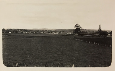
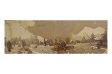
Photograph, Garden of 'Rockingham', Kew, c.1870
Built by John Bournane, Rockingham had a number of occupants before the newspaper magnate David Syme purchased it in 1902. The house in the 1860s and ‘70s was comprised of nine rooms, and was surrounded by a veranda on the front and sides. It was approached from the Kew road by the curve in front of the Hon. S.G. Henty’s mansion of ‘Findon’.In 1955, the Syme family sold Rockingham to the Red Cross Society to be used as a convalescent home for returned servicemen. The house was sold, demolished, and the land subdivided in 1966.An early panoramic photograph of an early Kew mansion (now demolished), dating from the 1870s.A rare, panoramic photograph (c.1870) of the garden of ‘Rockingham’, during the occupation of the house by W. Gardiner Esq. Rockingham was located beside and above the Barkers Road cutting. The view of the garden in the photograph is of the terraces leading down to the Yarra River. At the time the photograph was taken, the property covered an area of “…nine acres of beautifully laid-out grounds, interspersed with numerous terraces leading down the sloping bank of the river”.rockingham, david syme, kew -
 Kew Historical Society Inc
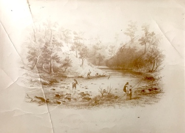
Print, View on the Yarra Near Dights Falls, Nineteenth Century
The original book plate reflects the colonial use of the River Yarra fro both recreation and industry.View on the Yarra Near Dights Falls. Reproduction of a book plate from an original wood engravingg, showing men and boys on the banks of the River Yarra. The activities represented include logging and fishing. Annotation on reverse: [Original] "Caption: View on the Yarra Near Dights Falls."yarra river, dights falls