Showing 111523 items matching "road"
-
 Kew Historical Society Inc
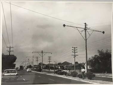
Photograph, Stuart Tompkins Studio, Electricity Supply Poles, Warrigal Road, Holmesglen, 1965
Research provided by Stuart Tompkins Studio, Box Hill, into alternatives for median strip street lighting to be used in Burke Road, Kew. The photographers identified variants in different suburbs appropriate to Kew's needs. The series from which the photograph is drawn provides a snapshot by a commercial photographic studio of each named vicinity in 1965 as well as providing examples of public works infrastructure being commissioned by local government in the 1960s. The photos originally formed part of the Engineering Department's files in the City of Kew before being donated to the kew Historical Society.Electricity Supply Poles, Warrigal Road, Holmesglen, 1965. Stuart Tompkins Studio provided this photograph for the Kew City Council. The photograph of Warrigal Road, north of Holmesglen looking north depicts wooden poles with bracket light fittings. These were the same as those proposed for Kew, except the lights and fittings were not to be 350 watt. Mercury lamps were preferred. [There are three copies of this photograph in the Collection.] Typed inscription on reverse: "Electricity Supply Poles. Photographed for Kew City Council 8/2/65. No.3 Warrigal Road - North of Holmesglen looking north. Wooden poles with bracket fittings same as those proposed for Kew except lights and fittings are not for 250 watt c. c. mercury lamps proposed. Wooden pole 3' up 11 3/4" dia." Studio stamp: "Stuart Tompkins Studio. 547 Station Street, Box Hill. WX1439."stuart tompkins studio, warrigal road (holmesglen) 1965, street lighting -
 Kew Historical Society Inc
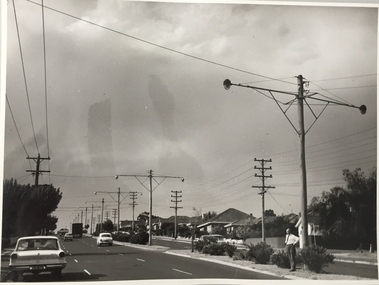
Photograph, Stuart Tompkins Studio, Electricity Supply Poles, Warrigal Road, Holmesglen, 1965
Research provided by Stuart Tompkins Studio, Box Hill, into alternatives for median strip street lighting to be used in Burke Road, Kew. The photographers identified variants in different suburbs appropriate to Kew's needs. The series from which the photograph is drawn provides a snapshot by a commercial photographic studio of each named vicinity in 1965 as well as providing examples of public works infrastructure being commissioned by local government in the 1960s. The photos originally formed part of the Engineering Department's files in the City of Kew before being donated to the kew Historical Society.Electricity Supply Poles, Warrigal Road, Holmesglen, 1965. Stuart Tompkins Studio provided this photograph for the Kew City Council. The photograph of Warrigal Road, north of Holmesglen looking north depicts wooden poles with bracket light fittings. These were the same as those proposed for Kew, except the lights and fittings were not to be 350 watt. Mercury lamps were preferred. [There are three copies of this photograph in the Collection.] Typed inscription on reverse: "Electricity Supply Poles. Photographed for Kew City Council 8/2/65. No.3 Warrigal Road - North of Holmesglen looking north. Wooden poles with bracket fittings same as those proposed for Kew except lights and fittings are not for 250 watt c. c. mercury lamps proposed. Wooden pole 3' up 11 3/4" dia." Studio stamp: "Stuart Tompkins Studio. 547 Station Street, Box Hill. WX1439."stuart tompkins studio, warrigal road (holmesglen) 1965, street lighting -
 Eltham District Historical Society Inc
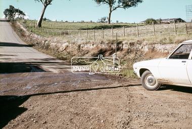
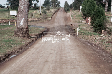
Slide, In front of Martin property drive on Bonds Road looking east up Montpelier Drive, Lower Plenty, 18 July 1972, 1972
Water drainage work undertaken by Eltham Shire Council in Bonds Road, Lower Plenty outside the Martin property opposite Montpelier Drive, July 197235 mm colour positive transparency Mount - Agfacolor Service (Blue)Bonds Road (Martin property) 12.10 pm 18.7.72bonds road, drainage works, eltham shire council, infrastructure, lower plenty, martin property, montpelier drive -
 Eltham District Historical Society Inc
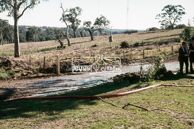
Slide, On the east side of Bonds Road looking west onto Martin's property, Lower Plenty, 18 July 1972, 1972
Water drainage work undertaken by Eltham Shire Council in Bonds Road, Lower Plenty outside the Martin property opposite Montpelier Drive, July 1972 35 mm colour positive transparency Mount - Agfacolor Service (Blue)Bonds Road (Martin property) 12.10 pm 18.7.72bonds road, drainage works, eltham shire council, infrastructure, lower plenty, martin property, montpelier drive -
 Eltham District Historical Society Inc
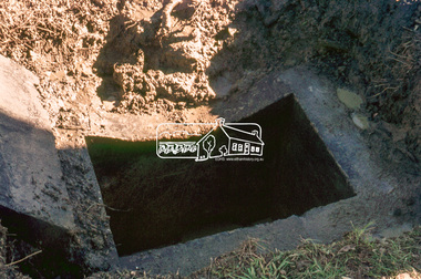
Slide, Pit located on the east side of Bonds Road, Lower Plenty, 18 July 1972, 1972
Water drainage work undertaken by Eltham Shire Council in Bonds Road, Lower Plenty outside the Martin property opposite Montpelier Drive, July 1972 35 mm colour positive transparency Mount - Agfacolor Service (Blue)Bonds Road (Martin property) 12.10 pm 18.7.72bonds road, drainage works, eltham shire council, infrastructure, lower plenty, martin property, montpelier drive -
 Eltham District Historical Society Inc
Slide, Looking westerly into Martin's property across Bonds Road, Lower Plenty, 18 July 1972, 1972
Water drainage work undertaken by Eltham Shire Council in Bonds Road, Lower Plenty outside the Martin property opposite Montpelier Drive, July 1972 35 mm colour positive transparency Mount - Agfacolor Service (Blue)Bonds Road (Martin property) 12.10 pm 18.7.72bonds road, drainage works, eltham shire council, infrastructure, lower plenty, martin property, montpelier drive -
 Eltham District Historical Society Inc
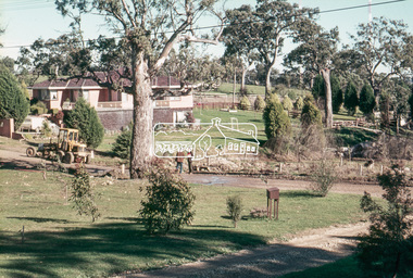
Slide, View of Martin's house indicating its relationship to the gully, Bonds Road, Lower Plenty, 18 July 1972, 1972
Water drainage work undertaken by Eltham Shire Council in Bonds Road, Lower Plenty outside the Martin property opposite Montpelier Drive, July 1972 35 mm colour positive transparency Mount - Agfacolor Service (Blue)Bonds Road (Martin property) 12.10 pm 18.7.72bonds road, drainage works, eltham shire council, infrastructure, lower plenty, martin property, montpelier drive -
 Eltham District Historical Society Inc
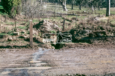
Slide, Looking south, post drainage repairs on Bonds Road near Martin property and Montpelier Drive, Lower Plenty, c.July 1972, 1972
Water drainage work undertaken by Eltham Shire Council in Bonds Road, Lower Plenty outside the Martin property opposite Montpelier Drive, July 1972 35 mm colour positive transparency Mount - Agfacolor Service (Blue)Bonds Road (Martin property) 12.10 pm 18.7.72bonds road, drainage works, eltham shire council, infrastructure, lower plenty, martin property, montpelier drive -
 Eltham District Historical Society Inc
Slide, Post drainage repairs on Bonds Road near Martin property and Montpelier Drive, Lower Plenty, c.July 1972, 1972
Water drainage work undertaken by Eltham Shire Council in Bonds Road, Lower Plenty outside the Martin property opposite Montpelier Drive, July 1972 35 mm colour positive transparency Mount - Agfacolor Service (Blue)Bonds Road (Martin property) 12.10 pm 18.7.72bonds road, drainage works, eltham shire council, infrastructure, lower plenty, martin property, montpelier drive -
 Eltham District Historical Society Inc
Slide, Looking north post drainage repairs on Bonds Road near Martin property and Montpelier Drive, Lower Plenty, c.July 1972, 1972
Water drainage work undertaken by Eltham Shire Council in Bonds Road, Lower Plenty outside the Martin property opposite Montpelier Drive, July 1972 35 mm colour positive transparency Mount - Agfacolor Service (Blue)Bonds Road (Martin property) 12.10 pm 18.7.72bonds road, drainage works, eltham shire council, infrastructure, lower plenty, martin property, montpelier drive -
 Eltham District Historical Society Inc
Slide, Post drainage repairs on Bonds Road near Martin property and Montpelier Drive, Lower Plenty, c.July 1972, 1972
Water drainage work undertaken by Eltham Shire Council in Bonds Road, Lower Plenty outside the Martin property opposite Montpelier Drive, July 1972 35 mm colour positive transparency Mount - Agfacolor Service (Blue)Bonds Road (Martin property) 12.10 pm 18.7.72bonds road, drainage works, eltham shire council, infrastructure, lower plenty, martin property, montpelier drive -
 Eltham District Historical Society Inc
Slide, Post drainage repairs on Bonds Road near Martin property and Montpelier Drive, Lower Plenty, c.July 1972, 1972
Water drainage work undertaken by Eltham Shire Council in Bonds Road, Lower Plenty outside the Martin property opposite Montpelier Drive, July 1972 35 mm colour positive transparency Mount - Agfacolor Service (Blue)Bonds Road (Martin property) 12.10 pm 18.7.72bonds road, drainage works, eltham shire council, infrastructure, lower plenty, martin property, montpelier drive -
 Ringwood and District Historical Society
Literary work - Biography, The story of Mrs McCann, 69 Warrandyte Road Ringwood dated December 1973, Dec-73
Written by Mrs. E. McCann. House was "Castle Crag" home of the A.T. Miles family 1916.The story of Mrs McCann, 69 Warrandyte Road Ringwood dated December 1973, 25 pages, started 8-Jan-1967 +Additional Keywords: McCann, Mrs. E. -
 Whitehorse Historical Society Inc.
Photograph, Canterbury Road in 1915, 1915
Part of Tim Shambrook's Collection for 'This is Vermont', P. 22.Black and white photo of Canterbury Road, Vermont, looking East, showing Mechanics Institute Hall which became Scout Hall. Old style street lamp in picture.vermont mechanics institute, mechanics institutes, vermont scout hall, shambrook, tim, scout halls -
 Eltham District Historical Society Inc
Photograph, Main Road widening, Eltham, c.March 1968, 1968
Duplication of Main Road. Looking south from site of Eltham Shire offices towards Shillinglaw Cottage. Gahan house to left of Shillinglaw Cottage facing Main Road almost completely demolished. Main Road to the left and the Eltham Tip to the right.Digital file created by stitching two 35mm Colour positive transparency Mount - Agfacolor Service (Blue stepped)duplication, eltham tip, gahan house, main road, shillinglaw cottage -
 Ballarat Heritage Services
Photograph, The Deserted Great Ocean Road at Apollo Bay during the Covid 19 Lockdown, 20/09/2021
During the Covid19 Pandemic lockdowns resulted in empty roads. Colour photographs of plaques commemorating the opening of the Great Ocean Road, 2020great ocean road, plaque, apollo bay, david mclaren, pandemic, covid19 -
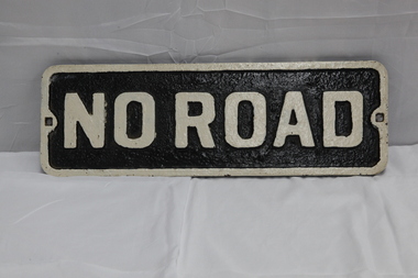 Puffing Billy Railway
No Road - End of platform sign
Historic - Railway - No Road Plate Sign Historic - Railway - No Road Plate Sign No Road Plate Sign Long rectangular plate that has been painted black and white with the words "no road" written across it. made of cast metal"No Road"puffing billy, sign, plate, no road sign -
 Ringwood and District Historical Society
Photograph, Wieland house at corner of Dickason Road & Canterbury Road on 30.9.1973
Wieland house at corner of Dickason Road & Canterbury Road on 30.9.1973. -
 Mt Dandenong & District Historical Society Inc.
Photograph, View From Corner of Doughty's Road and Barbers Road 1913
John Lundy-Clarke grew up in the Kalorama/Mt Dandenong area and later in life (1972-74) began to write a comprehensive history of the area working from an original settlement map in an effort to cover all areas. Taken c1913, this photograph gives a clear indication of where significant buildings were located in relation to one another. Barbers Road is running through the picture with the guest house 'Kia-Ora' , built by George Barber in the centre. High on the skyline on the left is the 'Mountjoy' guesthouse, indicating the location of The Gap, or FiveWays. The small 'boxy' house above 'Kia-Ora' is 'Iona' built by the Paynter family who also built 'Mountjoy'. The Jeeves property 'Kalorama' is to the right of 'Iona' and this is the area you now look to from the FiveWays Lookout. The man in the photo is wearing a trilby hat so is probably a Rose Series employee - a feature in many Rose Series postcards.Black and white photograph that is a copy of Rose Series Postcard # 156. A man can be seen walking down an unmade road with haystacks to his right. Buildings and crops can be seen on the hillsides. Handwritten inscription on reverse by John Lundy-ClarkeView from corner of Doughty’s and Barbers Road 1913. “Kia Ora” in centre Paynter’s “Iona” near center skyline above “Kia Ora” with “Kalorama” on its right and Peter’s hut of the time below it among orchard trees. “Mountjoy” is on left skyline. W. Haye’s home is centre left. Hay paddock is Barbers Lot 25 Village Settlement.kia-ora, iona, kalorama, mountjoy, guesthouse, guest house, barbers road, doughty's road, paynter, jeeves, george barber -
 Sunbury Family History and Heritage Society Inc.
Photograph, Rosa McCall, Anderson Road, Sunbury, February 2014
The street in the photograph is Anderson Road, taken from the Darbyshire Street end and looking towards the SE to Gap Road. It was taken in February 2014. A non-digital coloured photograph of a street with a two storey house and three single storey homes.anderson road, sunbury, darbyshire road -
 Warrnambool and District Historical Society Inc.
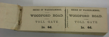
Functional object - Ticket Book, Fairfax & Laurie, Printers, Shire of Warrnambool, Woodford Road Toll Gate, 1s 6d, Circa 1866
In 1866, in an effort to maintain the main roads of the region it was decided to establish toll roads on the Belfast, Woodford, Purnim and Allansford roads. Gates were erected and the leases were disposed of by auction. In 1867 the Woodford tollhouse was destroyed by fire suspected to be deliberate. The tolls were removed three years later after much opposition.This item has historic significant as in the early years(1864) of Warrnambool Tolls were levied on the three main roads leading from Warrnambool into the Shire. In 1864 the Shire of Warrnambool decided that tolls were the only just way to raise funds for maintenance of metalled roads. the Shire of Warrnambool had been created in 1863 from the old Warrnambool Roads Board.Small booklet 140mms long by 40mms wide 13mm depth. Blue & grey marbled cardboard covers back & green oiled cloth binding. Inside full book of double side ticket stubs with perforations in the middle.Shire of Warrnambool. WOODFORD ROAD. TOLL GATE 1s. 6d. Fairfax & Laurie, Printerswarrnambool, shire of warrnambool, woodford road, main belfast road, toll gate, toll tickets, woodford toll house 1866, fairfax & laurie printers -
 Eltham District Historical Society Inc
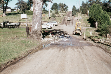
Slide, Looking south along Bonds Road towards intersection of Montpelier Drive, Lower Plenty, 18 July 1972, 1972
Water drainage work undertaken by Eltham Shire Council in Bonds Road, Lower Plenty outside the Martin property opposite Montpelier Drive, July 1972 Note blocked table drains.35 mm colour positive transparency Mount - Agfacolor Service (Blue)Bonds Road (Martin property) 12.10 pm 18.7.72bonds road, drainage works, eltham shire council, infrastructure, lower plenty, martin property, montpelier drive -
 Whitehorse Historical Society Inc.
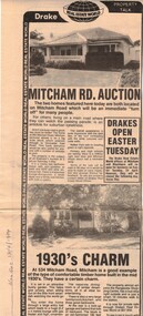
Newspaper, Mitcham Road auction, 01/04/1984,Nunawading
Advertisement for the sale of two homesAdvertisement for the sale of two homes, 265 Mitcham Road, Mitcham and 534 Mitcham road, Mitcham a 1930s timber home. Agent, drakes real estate. Photographs. Cutting from Nunawading Gazette, 18th April, 1984.Advertisement for the sale of two homesmitcham road, mitcham, no. 534, mitcham road, mitcham, no. 265, houses, drake & co. -
 Whitehorse Historical Society Inc.
Photograph, The Railway Crossing from Corner of Springvale Road & Station, 1/06/2009
One of a collection of photographs taken of the Nunawading Railway Station prior to the lowering of the railway line and building of the new railway station on the western side of Springvale Road so that the Springvale Road Rail Crossing can be eliminated.Black & white photograph of he precinct surrounding the Nunawading Station and the Springvale Road Railway crossing. This photograph is of the Railway Crossing from corner of Springvale Road & Station. See NP 3545 to NP3567for the complete set of photographsnunawading railway station, springvale road, nunawading, redevelopment of railway line/springvale road., station street nunawading -
Whitehorse Historical Society Inc.
Newspaper - Article, 519 Mitcham Road, Vermont, 8/03/1989
Article in Nunawading Gazette re sale of early 1900s home at 519 Mitcham Road, Vermont. One of the original homes in the area. In the early days the land was primarily used as a poultry farm.mitcham road, vermont, real estate, auctions -
 Eltham District Historical Society Inc
Slide, Pit on east side of Bonds Road, Lower Plenty, 18 July 1972, 1972
Water drainage work undertaken by Eltham Shire Council in Bonds Road, Lower Plenty outside the Martin property opposite Montpelier Drive, July 1972 Note rubbish excavated from pit.35 mm colour positive transparency Mount - Agfacolor Service (Blue)Bonds Road (Martin property) 12.10 pm 18.7.72bonds road, drainage works, eltham shire council, infrastructure, lower plenty, martin property, montpelier drive -
 Sunbury Family History and Heritage Society Inc.
Photograph, Rosa McCall, Anderson Road, February 2014
The street in the photograph is Anderson Road in Sunbury, looking towards Darbyshire Road and the NW. The driveway with the hoarding on the LHS leads to the former Sunbury Storage Business. The photograph was taken in February 2014.A non-digital coloured photograph of a street with four cars parked along it and an advertising notice on the LHS of the image. Some housing and open areas are visible in the distance.anderson road, darbyshire road, sunbury -
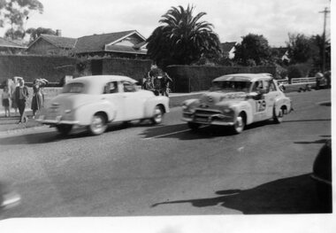 Surrey Hills Historical Society Collection
Digital photo, George L Coop, Redex trial on Whitehorse Road, Mont Albert, 1953, 1953
The FJ Holden is iconic in Australian motoring history. It was made in Australia by Holden from 1953 to 1956. During the 1950s, Holden dominated the Australian car market and by 1958 sales accounted for over 40 per cent of total car sales in Australia. The Redex Reliability Trial 1953 -The first Redex round-Australia reliability trial covered of 6,500 miles (10,500 km), and had a first prize of £1,000. It attracted both amateur and professional drivers in a variety of cars. The route passed through Brisbane, Rockhampton, Townsville, Darwin, Alice Springs, Adelaide and Melbourne before returning to Sydney and attracted much public interest. At the time the idea of driving huge distances around the country in ordinary cars was novel and the logistics were challenging. In many parts of the country there simply wasn’t adequate accommodation or suitably located refuelling stops. The Shell Company facilitated the race by placing petrol dumps along the 5000 km route between Townsville and Adelaide. The race began at the Sydney Showground on 30 August when 192 cars left at three-minute intervals. Of the twenty top finalists, two thirds were sponsored. Ken Tubman and John Marshall won the trial in a Peugeot 203. A black & white photo taken from near 688 Whitehorse Road. It includes 2 FJ Holdens - one is probably a passing car; the other is covered with labels and can assume to be competing in the trial. On the far side of the road are onlookers of men, women and one child standing on a wide nature strip. One man is taking photos. The houses behind are obscured by high hedges, but appear to be Californian bungalows, one with a large palm tree in its front garden.redex reliability trial, 1953, fj holden, whitehorse road, mont albert