Showing 40542 items matching "roads and streets"
-
 Whitehorse Historical Society Inc.
Photograph, Christ Church Mitcham, c1952
Sent to a parishioner at Christ Church Mitcham, by Phyllis Grant who lived at the Migrant Hostel in Mitcham in 1952-54, where her husband did development work with the P.M.G.Black and white photograph of Christ Church, Mitcham in Edward Street, looking from Whitehorse Roadchrist church anglican church mitcham, edward street, mitcham, whitehorse road -
 Canterbury History Group
Photograph - Youngs Milk Bar and Dairy, Susan Barnett, 1996
Black and white photograph of Youngs Milk Bar corner of Highfield Road and Leeds Street Canterburycanterbury, highfield road, leeds street, milk bars, shops, dairies, dairy farmers milk, herald sun, barnett> susan -
Canterbury History Group
Photograph - Street view of 3 shops in Canterbury Road, Canterbury, Stuart Warmington, 1994
Coloured photograph of Street view of 3 shops in Canterbury Road, Canterbury in a Victorian architectural stylecanterbury, canterbury road, shops, victorian architectural designs -
Canterbury History Group
Photograph - Street view of the laneway between Shop No.80 and No. 78 Maling Road, Canterbury, Stuart Warmington, 1995
Coloured photograph of street view of the laneway between Shop No.80 and No. 78 Maling Road, Canterbury.canterbury, maling road, shops, laneways -
Canterbury History Group
Photograph - Street view of Bradshaw's garage at Shop No. 87 - 101 Maling Road, canterbury, Stuart Warmington, 1995
Coloured photograph of Street view of Bradshaw's garage at Shop No. 87 - 101 Maling Road, canterburycanterbury, maling road, shops -
Canterbury History Group
Photograph - Street view of Bradshaw's Garage at Nos. 87 - 101 Maling Road Canterbury, Stuart Warmington, 1995
Coloured photograpg of the street view of Bradshaw's Garage at Nos. 87 - 101 Maling Road Canterburycanterbury, maling road, shops -
Clunes Museum
Postcard
A POSTCARD SHOWING A STREET SCAPE IMAGE OF 53 KERFORD ROAD, ALBERT PARK, VICTORIA, AUSTRALIAlocal history, greeting card -
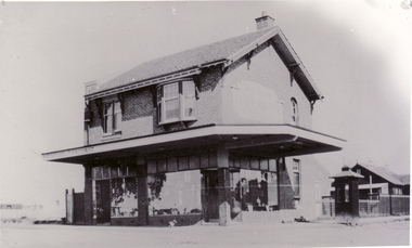 Whitehorse Historical Society Inc.
Photograph - Black and white photograph, Mitcham Post Office 1924, C1924
Black and white photo of Mitcham Post Office, corner Whitehorse Road and Station Street, Mitchampost office, mitcham, 1924 -
Canterbury History Group
Photograph - Street view of gift shop at No. 90 Maling Road, Jan Pigot, 27/03/1993 12:00:00 AM
Coloured photograph of the outside street view of gift shop, Ring a Roses at No. 90 Maling Roadcanterbury, maling road, shops, street views -
Canterbury History Group
Photograph - Street view of Bradshaw's Garage at Nos. 101 to 87 Maling Road, Jan Pigot, 27/03/1993 12:00:00 AM
Coloured photograph of the street view of David Bradshaw's Garage at Nos. 101 to 87 Maling Roadcanterbury, maling road, shops -
Canterbury History Group
Photograph - Old street sign of Theatre Place in Theatre Place, Maling Road, Canterbury, Jan Pigot, 1994
Coloured photograph of old street sign of Theatre Place in Theatre Place, Maling Road, Canterburycanterbury, maling road, signs -
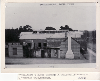 Whitehorse Historical Society Inc.
Photograph - B/W Photograph, O'Callaghan's Pub Corner, C1924
O'Callaghan's hotel was one of three 'hotels' which operated in Mitcham in the late 19th century. Suited on the corner of Station St and Whitehorse Road it was run by Irish widow, Mary Jane O'Callaghan. She died in 1916 and the hotel was de-licensed in 1917 and this photo was taken shortly before the building was demolished in 1924.Black and white photo of O'Callaghan's Pub Corner, cnr Station Street and Whitehorse Road, Mitcham. Large photograph filed in 2Eo'callaghan, mary, o'callaghan pub corner -
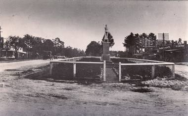 Whitehorse Historical Society Inc.
Photograph - Black and white photograph, War Memorial Mitcham, C1930
Black and white photo of War Memorial in Whitehorse Road,Mitcham.The much travelled (located and relocated) soldier has been placed n many since the end of WW1:|1. Centre of Whitehorse Road within reserve midway between Mitcham Road and Station Street |2. Closer to Mitcham Road and on the garden /lawns between Whitehorse Road (main throughway) and the northern service| road. 3. On his pedestal outside the Memorial Hall on the corner of Whitehorse Road and MacDowall Street.|4. Currently mounted in the gardens of Halliday Park in Mitcham Rd.war memorial mitcham, whitehorse road -
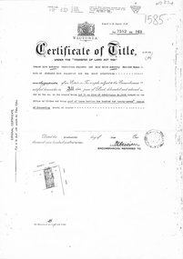 Whitehorse Historical Society Inc.
Document, Certificate of Title, 1/06/1951
Certificate of Title Vol 7583 Fol 060, being Lot 72 on Plan of Subdivision No 6626, 50 Burnett Street, Mitcham, with Plan of Subdivision No 6626 including Burnett Street, Thomas Street, bordered by Cook Street and Cook Street and Whitehorse Road, Mitchamburnett street, mitcham, no 50, thomas street, cook road, whitehorse road -
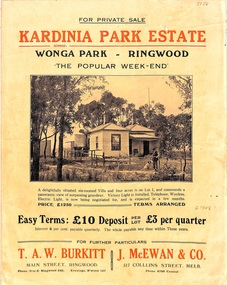 Ringwood and District Historical Society
Flyer, Land Sale Brochure, Kardinia Park Estate, North Ringwood, Vic. - circa 1948
Folded buff-coloured land sale advertisement for Kardinia Park Estate in Warranwood area of North Ringwood, including terms of sale, area map, layout plan of the estate, and summary of local facilities and services. Front page features photograph of a man and dog in front of a house captioned as Lot 1 on four acres shown on the estate layout as cnr of Brysons Road and Range View Parade (later Omeo Parade). Second page includes bushland swimming pool photograph and promotional information for prospective buyers.Subdivision includes Kardinia Crescent, Wonga Road, Brysons Road, Range View Parade (later Omeo Parade), Motor Coach Road (later Wonga Park Road, then Warranwood Road). (Agent/s) T.A.W. Burkitt, Main Street, Ringwood, Phone (9 to 6) Ringwood 242, Evenings, Ringwood 157, and J. McEwan & Co, 317 Collins Street, Melbourne, Phone 6750 Central. -
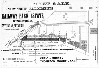 Ringwood and District Historical Society
Flyer, Subdivision advertisement - Railway Park Estate, Ringwood, Victoria - circa 1887
Photocopy of advertisement for auction sale of township allotments in Railway Park Estate, Ringwood, on Saturday 30th April (1887?), with terms of sale and location map.Subdivision map includes Pitt Street and Main Ferntree Gully Road (later Bedford Road). (Agents) Greig & Murray, Thompson Moore & Son, Auctioneers. -
Whitehorse Historical Society Inc.
Map, City of Nunawading, 1973
Map showing streets, plot numbers, schools, open space and land usage.Map showing streets, plot numbers, schools, open space and land usage. A project by A Gray, student at Vermont High School. Area covered from Canterbury Road to Burwood Road and Terrara Road to Morack Road. Scale: 800 ft: 1 inchMap showing streets, plot numbers, schools, open space and land usage.vermont south, vermont, vermont high school, parks and reserves -
 Kew Historical Society Inc
Photograph - Entrance to the Boroondara General (Kew) Cemetery, E.J. Dower, 1913
One of a series of photographs, taken by Edgar James Dower in the second decade of the twentieth century. Born and raised in Olinda, his family later moved to Surrey Hills. He worked as an adult as a clerk in the city office of the Metropolitan Gas Company, and in his role as a 'collector', he was able to photograph scenes including the construction of tramlines and associated buildings in Kew, Hawthorn, Camberwell and Surrey Hills. Later he established a real estate agency with his brother - the E.J. Dower Real Estate Agency, Dandenong Office.The image is an historically significant record of the development of transport infrastructure which was used to connect Victorians in the first two decades of the twentieth century. This development resulted from increases in population and the consequent extension of Melbourne's suburbs. The photographs, both individually and collectively, richly detail the labour of workers and the tools and machinery used to create and extend Melbourne's tram network in the years preceding and during World War 1.Digital copy of an original mounted photograph showing the entrance to the Boroondara General (Kew) Cemetery in 1913. The entrance was/is on the corner of High Street and Parkhill Road. The horse drawn tram from Victoria Street Bridge to the Cemetery can be seen to the left of the photo in High Street. Note also the extensive bluestone gutters in Parkhill Road.Annotated verso: "Entrance to Kew Cemetery? / 1913"theme --- travelling by tram, theme -- connecting victorians by transport and communications, trams -- kew (vic.), high street. -- kew (vic.), parkhill road -- kew (vic.) -
 Kew Historical Society Inc
Plan - Subdivision Plan, Flower Farm Estate, East Kew, 1922
Pru Sanderson, in her groundbreaking ‘City of Kew Urban Conservation Study : Volume 2 - Development History’ (1988), summarised the periods of urban development and subdivisions of land in Kew. The periods that she identified included 1845-1880, 1880-1893, 1893-1921, 1921-1933, 1933-1943, and Post-War Development. These periods were selected as they represented periods of rapid growth or decline in urban development. An obvious starting point for Sanderson’s groupings involved population growth and the associated economic cycles. These cycles also highlighted urban expansion onto land that was predominantly rural, although in other cases it represented the decline and breakup of large estates. A number of the plans in the Kew Historical Society’s collection can also be found in other collections, such as those of the State Library of Victoria and the Boroondara Library Service. A number are however unique to the collection.The Kew Historical Society collection includes almost 100 subdivision plans pertaining to suburbs of the City of Melbourne. Most of these are of Kew, Kew East or Studley Park, although a smaller number are plans of Camberwell, Deepdene, Balwyn and Hawthorn. It is believed that the majority of the plans were gifted to the Society by persons connected with the real estate firm - J. R. Mathers and McMillan, 136 Cotham Road, Kew. The Plans in the collection are rarely in pristine form, being working plans on which the agent would write notes and record lots sold and the prices of these. The subdivision plans are historically significant examples of the growth of urban Melbourne from the beginning of the 20th Century up until the 1980s. A number of the plans are double-sided and often include a photograph on the reverse. The subdivision called the ‘Flower Farm Estate’ in Kew East occurred in 1922. It included 61 lots on either side of Boorool Road between High Street and Harp Road. In an advertisement in The Argus in the same year, the proximity of the estate to the newly erected shops at the corner of Harp Road and High Street is noted. The Flower Farm Estate and similar subdivisions in Kew East were assisted by the extension of the High Street tramline in 1924.subdivision plans - east kew, flower farm estate, high street - kew east (vic.), boorool road -- kew east (vic.), harp road -- kew east (vic.) -
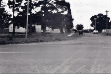
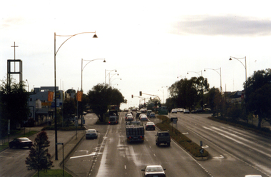 Whitehorse Historical Society Inc.
Photograph, Whitehorse Road, Mitcham
Coloured photograph of Whitehorse Road, Mitcham. Lights are at the junction of Whitehorse and Mitcham Roads and traffic on left is heading east towards Ringwood. Church on the left is the Mitcham Anglican Church, which is on the corner of Whitehorse Road and Edwards Street.whitehorse road, mitcham -
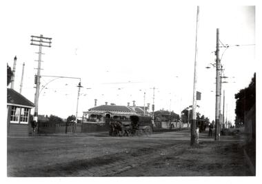 Melbourne Tram Museum
Photograph - Black & White Photograph/s, c1919
Black and White Photograph of a view of the intersection of Burke and Whitehorse Roads with a tram at the terminus in Burke Road. In the view is a horse drawn vehicle turning into Whitehorse Road, a shelter, tram overhead, street lighting and grand house on the corner.On rear in ink, "At Burke & Whitehorse Rds 1919c"trams, tramways, whitehorse rd, burke rd, pmtt, shelters -
Port Melbourne Historical & Preservation Society
Map, Port Melbourne Sheet 4, 1962
Framed line drawn map of Port Melbourne (sheet 4) 1962, covering the area from Beach Street (including Station and Princes Piers) to Plummer Street and Todd Road area to Dow Streetbuilt environment -
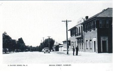 Hume City Civic Collection
Photograph, Early 1950s
A copy of one of the few postcards of Sunbury produced in the 1950s. It may have been produced for the 'Back to Sunbury' celebrations in 1952.A photocopy of a postcard showing the Royal Hotel on the corner of Evans Street and Brook Street looking east towards O'Shanassy Street. Two men are standing on the corner and the roads are not made and there are cars parked along the footpath.S. DAVIES SERIES NO 6 BROOK STREET SUNBURYbrook street, sunbury, hotels, evans street, postcards, festivals and celebrations, men, clothing and dress, transport, royal hotel, 1950s, george evans collection -
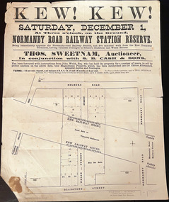 Kew Historical Society Inc
Plan, Kew! Kew!, 1888
The Land Boom of the 1880s accelerated the rate of subdivisions in Kew. This subdivision, 'Kew! Kew!' was also impacted by, or resulted from, the decision by the Victorian Government to construct the Outer Circle railway. Construction of the railway began in 1888 and was completed in 1891. Plan of an 1888 subdivision bounded by Bulleen Road (now High Street), Gladstone Street (now Campbell Street?), Park Street (now Adeney Avenue), and Belmore Road (now Harp Road). The 16 lots in the proposed subdivision are bisected by the route of the Outer Circle railway, and next to the proposed Normanby Station (later renamed East Kew). On the plan, local landmarks such as the tram terminus, the Harp of Erin hotel, and the station are located. The street where the lots are numbered , was called Welsh Street on the plan as this was the name of the vendor. Surrounding land owners are also named: G. Smith Esq, Matthew Maher Esq, and Maurice Neligan Esq.outer circle railway, land subdivisions -
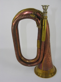 Frankston RSL Sub Branch
Bugle, 1911
The bugle was most likely used in the First World War for ceremonial and military operational functions. Bugles were an effective means of passing fixed messages and times over the noise and distance of battles and battlefields. Henry Potter & Co was a well known manufacturer of military bugles for the First World War. Military copper bugle with brass trim and silver (?) mouthpiece with brass retaining chain. inscribed "Henry Potter & Co" "38 West Street, Charing X Road, London 1911"world war one, ww1, brass, musical instrument, bugle, henry potter -
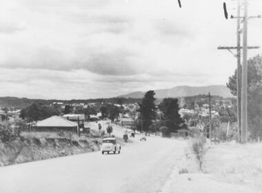 Ringwood and District Historical Society
Photograph, Maroondah Highway West- Ringwood- c1949. Easterly view from Heatherdale Road along Whitehorse Road
Black and white photograph (2 large, 1 small)Written on back of photograph: "Main Street from Ringwood hill (near Heatherdale Road) c1949" -
 Ringwood and District Historical Society
Plan - Proposed Ringwood East Railway Station, VR Ringwood-Croydon (Dublin Road) - 1923
Technical drawing of "Proposed Station At 16Mls 38Chs 89Lks (Dublin Road)" inluding boundary line, red shaded platform with station buildings, and green shaded possible future "up" track. Surrounding streets include Dublin Road, Patterson Street, and subsequent hand-written additions of Railway Avenue, Lawrence Grove, Stanley Avenue, Wenwood Street, and Lois Street. Land title details of Patterson Street properties mainly illegible.Scale: 40'=1". Possible future (platform) extension for 8 car trains (and) extension for 10 car trains. -
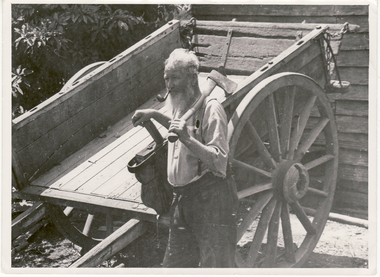 Whitehorse Historical Society Inc.
Photograph, Bill Cook
Black and white photo of Bill Cook. Cook Road in Mitcham named after him. Cook Street (Cook Road) formed the Western Boundary of his orchard in Mitcham.cook, bill, cook road, mitcham -
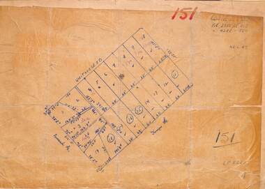 Ringwood and District Historical Society
Map, Plan of Subdivision
Hand-drawn map on light cardboard backing. 20 residential allotments in Whitehorse Road, Everard Road and Kemps Street, Ringwood East, Victoria (undated circa 1940s).Vol 3956 Fol 015, Vol 4288 Fol 564, LP5252. -
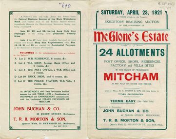 Whitehorse Historical Society Inc.
Document, McGlone's Estate, 1/04/1921 12:00:00 AM
Brochure on McGlone's Estate, Mitcham. auction of 24 allotments, April 1921.Brochure on McGlone's Estate, Mitcham. auction of 24 allotments, April 1921. Bordered by Station Street, Whitehorse Road, McGlone Street and Mitcham railway line and stationBrochure on McGlone's Estate, Mitcham. auction of 24 allotments, April 1921.land sales, auctions, mcglone, john, elizabeth, mitcham post office, mitcham police station, station street, mitcham, mcglone street, whitehorse road