Showing 685 items
matching robert hills
-
 Whitehorse Historical Society Inc.
Article, Forest Hill Post Office, 1874
A history of the Forest Hill Post Office.A history of the Forest Hill Post Office.A history of the Forest Hill Post Office.forest hill post office, post offices, peacock family, peacock robert, peacock catherine, mcarthur archibald -
 Whitehorse Historical Society Inc.
Book, Box Hill High School Memoir, 1/12/2015 12:00:00 AM
... 'To Strive Higher' Box Hill High School Hayes Robert L. Hiscock Peter ...A Collective Memoir of the Box Hill High School; 1950-55 Cohort and the Foundation Matriculation Class.A Collective Memoir of the Box Hill High School; 1950-55 Cohort and the Foundation Matriculation Class. School Motto 'Ad Altiora Certarrus' meaning 'To Strive Higher'A Collective Memoir of the Box Hill High School; 1950-55 Cohort and the Foundation Matriculation Class. box hill high school, hayes, robert l., hiscock, peter mcl., smith, graeme c. -
Whitehorse Historical Society Inc.
Article, Blood's Cottage
... Blood's Cottage Box Hill Pioneer's House Blood Robert Robert Blood ...Robert Blood built his pioneer cottage at 519 Station Street, Box Hill in 1854.Robert Blood built his pioneer cottage at 519 Station Street, Box Hill in 1854. It was demolished in 2000 and a pallet of bricks is all that remains of it which is stored at the council's operation centre.Robert Blood built his pioneer cottage at 519 Station Street, Box Hill in 1854. city of whitehorse, station st box hill no. 519, blood's cottage, box hill, pioneer's house, blood, robert -
 Whitehorse Historical Society Inc.
Document - Research paper, Forest Hill Post Office, Feb 2020
... Mitcham melbourne The Forest Hill Post Office was established ...History of Forest Hill Post Office and its early postmasters and mistress from the Peacock family4 pages single sided, A4non-fictionHistory of Forest Hill Post Office and its early postmasters and mistress from the Peacock familyforest hill post office, peacock robert, peacock family, peacock catherine, mcarthur archibald, scotchman's hill, mount pleasant -
 Ballarat Heritage Services
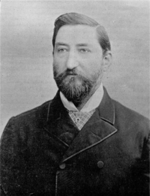
Image, Dr Robert Denham Pinnock
Originally published in Ballarat and Vicinity.Photographic portrait of Dr Robert Denham Pinnock.dr robert denham pinnock, robert pinnock, dr pinnock, portrait -
 Ballarat Heritage Services
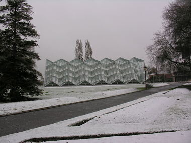
Photograph - Photograph - Colour, Robert Clark Centre in the Snow, Ballarat Botanical Gardens, c2009
Colour photograph of snow at the botanical Gardens in Ballarat.glasshouse, ballarat botanical gardens, snow -
 Ballarat Heritage Services
Photograph - Photograph - Colour, Clare Gervasoni, Kalimna Honour Board, 27/08/2017
This honor board was made by Robert Prenzel (1866–1941) who was born and trained in Prussia, and migrated to Australia arriving in Melbourne on 24th November on the steamer Habsburg. In Melbourne Prenzel first worked for the German sculptor and modeller Otto Waschatz, decorating private homes and public buildings. From 1891-1901 Prenzel worked in partnership with another German, Johann Christian Treede, after which he continued in business on his own. He also participated in the activities of Melbourne’s Deutscher Turnverein. During the first quarter of the current century he became the major exponent in the field of furniture and woodwork of the cult of nationalism, and was renowned for his carvings, many of them in the art nouveau style, of Australian animals, birds, trees and flowers. The two most common types of Australian timber in his work are mountain ash and blackwood.Colour photographs of a beautifully carved World War One Honour Board carved by Robert Prenzel.world war one, kalimna, kalimna honour board, h. clements, w.a. fish, d. mcdougall, j.a. rowe, c.c. sandford, c.d. somerville, l.j. cowlishaw, l.c. fish, t. hanson, c.a. innes, a.c. lester, j.a. lake, g.j. ward -
 Ballarat Heritage Services
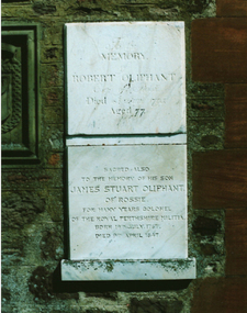
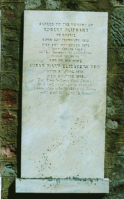
Photograph - Colour, Robert James Oliphant plaque, Forgandenny Church, Scotland
... Ballarat Heritage Services PO Box 2209 Bakery Hill Post ... -
 Ballarat Heritage Services
Photograph - Colour, Robert Oliphant of Rossie plaque, Forgandenny Church, Scotland
... Ballarat Heritage Services PO Box 2209 Bakery Hill Post ... -
 Ballarat Heritage Services
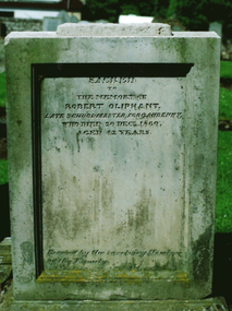
Photograph - Colour, Dorothy Wickham, Robert Oliphant, tombstone 1860, Forgandenny Churchyard, Scotland, 2017
Photograph of the Robert Oliphant plaque, tombstone 1860, Forgandenny Churchyard, ScotlandPhotograph of the Robert Oliphant, tombstone, Forgandenny Churchyard, Scotlandrobert oliphant plaque, tombstone 1860, forgandenny churchyard, scotland, robert oliphan -
 Ballarat Heritage Services
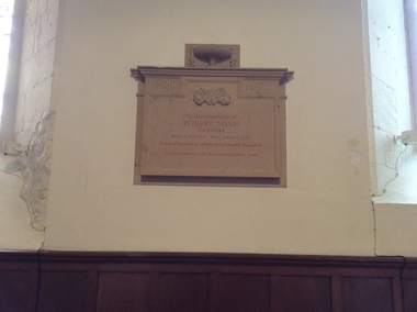
Photograph - Photograph - Colour, Plaque to the memory of Robert Adam, architect, GreyFriars Church, Edinburgh
-
 Ballarat Heritage Services
Photograph, Holy Cross, Daylesford, c1945
Photograph taken inthe grounds of the Holy Cross Convent, Daylesford. Daniel Mannix (centre left) is played by John Hogan Gervasoni, and Robert Rodoni playes St Patrick (centre)holy cross convent dayleford, daylesford convent, daylesford, st patrick, daniel mannix -
 Ballarat Heritage Services
Photograph - Colour, Clare Gervasoni, Kelland Memorial , Warrnambool Cemetery, 27/07/2009
Kelland memorial in the Warrnambool Cemetery in marble showing clasped hands and draped meaterial with tassel.warrnambool cemetery, cemetery art, tombstone art, robert kelland, christina kelland, willaim giles kellend, emma kelland -
 Ballarat Heritage Services
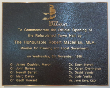
Photograph - Colour, Plaque in the Ballarat Town Hall, 2017, 15/09/2017
Photograph of a plaque in the Ballarat Town Hall.ballarat town hall, refurbishment, robert macellen, james coglan -
 Ballarat Heritage Services
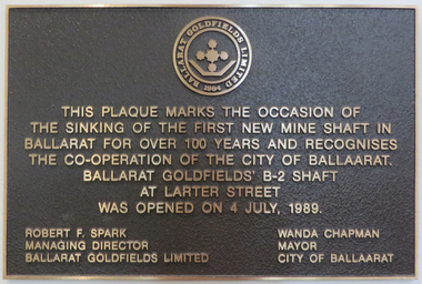
Photograph - Colour, Plaque in the Ballarat Town Hall, 2017, 15/09/2017
Photograph of a plaque in the Ballarat Town Hall.ballarat town hall, ballarat goldfields limited, mine shaft, robert f. spark, wanda chapman -
 Ballarat Heritage Services
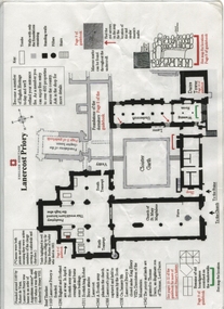
Plan, Lanercost Priory, Digital copy made 2016
Lanercost Priory was founded around 1169 by Robert de Vaux, and was home to an order of Augustinian canons until 1538 when is was dissolved by Henry VIII. In 1542 the priory and lands were granted to Thomas Dacre, an illegitimate son of Thomas, Lord Dacre. Mason's marks can be found throughout the undercroft. Plan on white paper with black and red ink printing and a drawingEnglish Heritage Lanercost Priorymason's marks, marks, stone marks, stonemasons, lanercost, priory, plan, 1169 -
Ballarat Heritage Services
Booklet, Scotsburn: The Early Settlers 1838-1988, c1988
Scotsburn is near the Victorian town of Buninyong. It was named after squatter Andrew Scott, and Celia Scott.A book relating to the history of Scotsburn and its early community. andrew scott, celia scott, kirkland, yuulong, matthew allison, lal lal, william cresswell, george ernest harbour, yendon, george zennis hudson, joseph jackson, isabella jackson, domenico lorensini, italian gully, domenico fanchi, sarah buckle, arnold buckle, ellis pearce, robert platt, david matthews, john shearer, ada jamieson, ernest alfred skelton, james allison, william stepnell, margaret stepnell, john white, dorcas white, scotsburn state school, scott's marsh post office, scotsburn union church, thomas hastie, scotsburn hall, john henty, scotsburn -
 Ballarat Heritage Services
Photograph, Clare Gervasoni, Headstones in Smeaton Cemetery, 29/09/2013
Headstones in the Smeaton Cemetery.smeaton, smeaton cemetery, headstones, james eckersley, g.l. nase, anna maria nase, alice maria nase, john edwin dean, anna m. dean, anna maria dean, a. broom, mccrum, ann mccrum, jean dow, andrew wilson, samuel lilley, edmund fulton lilley, robert cowie, helen mcintosh -
 Ballarat Heritage Services
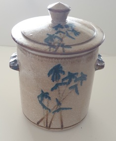
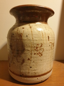
Photograph, Lidded ceramic vessel with Bamboo like design
... Ballarat Heritage Services PO Box 2209 Bakery Hill Post ...Robert MAIR Robert (Bob) Mair (1943- ) Born New Zealand A potter who trained at the Sturt Pottery in Mittagong under Les Blakebrough and later set up a pottery at Clifton Pugh’s Dunmoochin estate at Cottles Bridge near Melbourne. He then worked with John Olsen for two years from 1969-1970, with Mair throwing and Olsen hand-decorating the pots. During the 1970s, Bob Mair worked in goldfield production pottery in Ballarat with Robert Pitman before moving to Clarendon in the Adelaide Hills in South Australia in 1982. In the late 1880s and 1990s Robert Mair is working at Sturt Pottery timeline again in the late 1980s/1990s as a visiting potter under Campbell Hegan. In the early 2000s, he and partner Janie Kerr set up a pottery at Braemar in the Southern Highlands of NSW. They then moved, first to Sutton Forest where they took up a residency at Hillview, the former summer residence of the governors of NSW, then to Wingham in the Mid North Coast region of NSW. Mair’s work may be marked with an impressed ‘RM’, an impressed tricuspid symbol or both. In Clarendon, he continued to use the tricuspud symbol with an impressed ‘Old Clarendon Pottery Adelaide’ stamp. A Ballarat mark has not been identified, but simse this lidded pot was found in Ballarat it could be a cross in a circle?Lidded ceramic container with blue bamboo like design on the outside.australian studio pottery, ceramics, bamboo -
 Ballarat Heritage Services
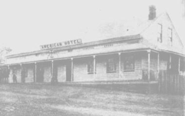
Photograph, American Hotel, Hepburn, 1900, 1900
The American Hotel was destroyed in the Hepburn Bushfire of 1906. A weatherboard hotel in Hepburn run by Robert Righetti. In 1900 Cobb and Co Coaches from Dayelsford left the American Hotel every two hours. daylesford, american hotel, hepburn, robert righetti -
 Ballarat Heritage Services
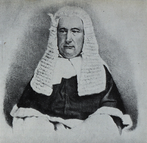
Photograph - Image, Robert Molesworth
... Ballarat Heritage Services PO Box 2209 Bakery Hill Post ...Image of Robert Molesworth in legal regalia.robert molesworth, judge, legal -
Ballarat Heritage Services
Work on paper, Robert Jacks, Yellow Guitar, 2003, 2003
... Ballarat Heritage Services PO Box 2209 Bakery Hill Post ...robert jacks, silkscreen -
 Ballarat Heritage Services
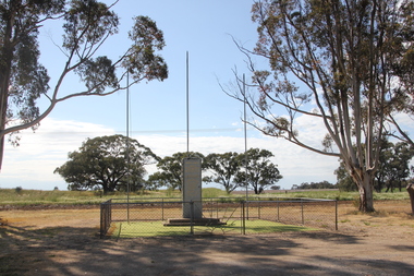
Photograph, Clare Gervasoni, Sheep Hills War Memorial, 2017, 08/10/2017
... Pleass Gove George Laing Herman Percy Robert Schultz Sheep Hills ...Sheep Hills is located Sheep Hills in the northern Wimmera region, north-west Victoria between Warracknabeal and Minyip.The Sheep Hills cenataph is opposite the Mechanics' Institute. The cenotaph commemorates those from the district who served in World Wars One and Two and lists the names of those who died in the conflict. Sheep Hills War Memorialsheep hills, sheep hills cenataph, sheep hills war memorial, allan albert, walter robert childs, joseph william darling, william pleass gove, george laing, herman percy robert schultz -
 Ballarat Heritage Services
Photograph - Black and White Photograph, Bess Gervasoni in the yard at Roberts Grocery Shop, c1935
The former Robert's Grocery Shop (formerly Kings Grocery Store), was converted to the Central Springs Hotel, c1985.Elizabeth (Bess) Gervasoni in the yard at King's Grocery Shop where she lived during World War Two. john hogan gervasoni, robert's grocery shop, robert's grocery store, central springs hotel -
 Ballarat Heritage Services
Ceramic - Pot by Robert Gordon
... Ballarat Heritage Services PO Box 2209 Bakery Hill Post ...Robert GORDON Robert 'Andy' Gordon is a potter supplying ceramic wares to stores across Australia as well as exporting to Canada, the U.S.A. and New Zealand. to China. Robert and his wife Barbara started making pottery in 1979 in a tin shed at Gembrook in the Dandenongs, Victoria, which they called the Pack Track Pottery, selling their wares at the St Kilda markets. In 1987, they expanded to purpose-build premises in nearby Pakenham where they are still based today. Wares made at Pack Track Pottery are painted 'Robert Gordon' or 'Gordon' in oxide. Wares made at the Robert Gordon Pottery are stamped 'Robert Gordon Pottery Australia', 'Robert Gordon Pottery Australian Made' or 'Robert Gordon Australia'. Glazed potrobert gordon, australia studio pottery, ceramics, pack tack poyyert, pack tack pottery -
 Ballarat Heritage Services
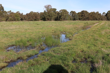
Photograph - Digital photograph, Winter's Swamp surrounds, April 2014
The swamp was named after John (Jock) Winter. John Winter (Jock) was born in Berwickshire, Scotland. He married Janet Margaret Irving the daughter of Robert Irving, advocate, Bonshaw, Dumfries, Scotland. Winter died in Ballarat in 1875 and was buried at the Ballaarat Old Cemetery. He took up the run Bonshaw from 1841; Leigh River Buninyong 1842-46; Junction, Delatite, March 1851 to September 1862; with sons: Carag Carag and Corop, April 1857 to September 1872; Colbinabbin and Stewart’s Plains, April 1857 to December 1872; St Germains February 1867 to March 1871. (The name became Winter-Irving in 1890). Mr John Winter, who died on August 22 at the age of 72, was a man of some note it the mining community of Ballarat. He was a self-made man, and one of our oldest colonists, it being over a quarter of a century age since he took up county about Ballarat and settled at Bonshaw. He died very rich. It is calculated that if he had retained an interest in all his runs, his income must have been not less than £10,000 or £50,000 a year. Some eight or ten years ago he sold his Bonshaw pre-emption to the Bonshaw Gold mining Company for £20,000, and a few years later the ground belonging now to Winter's Freehold Company brought him £50,000 more, the payment being made at the requisition of the deceased in sovereigns. In these relations Mr. Winter has been closely identified with the mining industry at Ballarat. The deceased was a native of Lauder, in Berwickshire, and landed in Victoria several years before the gold discovery. BHS were commissioned by Ballarat Environment Network for a project on Winter's Swamp and Skipton Common. Winter's Swamp was part of Ballarat West Common. The principle task of this project was the delivery of a report outlining the history of European settlement in the Skipton and Cardigan/Ballarat districts as pertinent to the use of and impact on the natural environment of the two reserves Skipton Common and Winter Swamp. The report was delivered in digital form only. The report, upon completion, was presented to the Network’s Committee in order to discuss the project. The report identified and described the uses of Skipton Common and Winter Swamp, and their impacts. In particular, this report examined farming/grazing (official and informal), mining, vegetation removal (including the removal of woodlands for timber, grasslands for pasture improvement) & use of riparian areas for access to water and timber removal. Recording the more benign and environmentally friendly uses such as picnicking, community activities, nature walks and the roles of organisations such as Field Naturalists’ and Bird Observers’ clubs, school and scout/guide groups will be relevant in helping to depict overall community attitudes towards the reserves; e.g.: has the Common generally been viewed as little more than a grazing paddock and fire hazard; has Winter Swamp always been the unknown natural asset that seems to have been its lot for at least the past 40 years? In this regard, the more contemporary history of actions surrounding the use and management of the reserves is of particular interest, in view of the extant evidence at both reserves; e.g. the actions of the Shire of Ballarat in the 1980s in establishing Winter Swamp as something of a competitor to Lake Wendouree but with a more environmental bent (although almost none of the plants used are indigenous species, but that is part of the story); the trotting track constructed on Skipton Common in the 1960s following representations to Premier Henry Bolte and the cropping of the western section of the Common to raise funds for the town’s new swimming pool, the fertilizing of the land putting an end to the native grassland vegetation. There are obviously multiple sources of information to source in preparing the report, however sources that the contractor is specifically requested to consult are the Skipton Historical Society, the former Skipton Common managers (specifically Graeme Pett), the Cardigan Windermere Landcare Group and the Learmonth Historical Society (believed to hold many of the former Shire of Ballarat’s records pertaining to the Council’s role as the Committee of Management for both Winter Swamp and the Ballarat West Town Common – Winter Swamp was split between 2 separate Crown Land tenures). The contractor is also encouraged but not required to utilise community newsletters, such as the Skipton Community Newsletter, to publicise and seek information about the project. Skipton Historical Society (Mary Bradshaw) contacted on Thursday 12 June 2.30pm. Mary lived on a farm out of Skipton but is currently living in the township. She remembers walking along the creek of the Common especially in spring and autumn in bare feet and that it was a very pretty place. There were a few snakes around the waterway in summer. People put cows and a couple of horses on the commonage to graze. Graeme Pett has always lived close to the Common and would know a lot about it. Other possible contacts would be Nicole Petress, Secretary of the Progress Association, and the Corangamite Council, Camperdown. Mary can’t remember any photos in the Skipton Historical Society that pertain to the Common. Digital photos of Winter's swamp surrounds, later known as Mullawullah.winter, winter's swamp surrounds, winter's swap, john winter, ballarat environmental network, ballarat, mullawullah -
 Ballarat Heritage Services
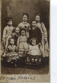
Photograph - Black and White, Batten Family, 1870+
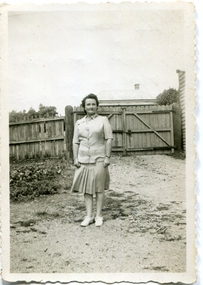
Children of William Henry Batten L to R back: Lucy Alice, Anne, Florence Ellen Centre: Agnes, Margaret, Robert (Their mother Anna Maria Brommell died 1869) Sitting: Sarah Amy, Mabel Jessie (mother Kate Taylor - 9 more children came later)Photograph sepiaBATTEN FAMILY verso "2"william batten, william henry batten, lucy batten, anne batten, florence batten, agnes batten, anna batten, anna brommell, mabel batten -
 Ballarat Heritage Services
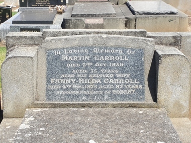
Photograph - Colour, Clare Gervasoni, Headstone of Martin and Fanny Carroll in the Tower Hill Cemetery, 2019, 03/01/2019
Colour photographs of the headstone of Martin and Fanny Carroll in the Tower Hill Cemetery.In Loving Memory of Martin Carroll Died 2nd Oct. 1959 Aged 75 Years. Also his beloved wife Fanny Hilda Carroll Died 4th Nov. 1975 aged 87 years Beloved Parents of Robert. R.I.P.tower hill cemetery, martin carroll, fanny hilda carroll, robert carroll -
 Ballarat Heritage Services
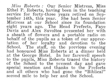
Newspaper - Newspaper article, Miss Roberts, Ballarat East High School
Miss Roberts: Our Senior Mistress, Miss Ethel P. Roberts, having been in the teaching service for forty-three years retired on September 14th this year. She had been senior mistress at our School since its foundation eight years ago. The Head Prefects, Faye Davis and Alex Suvoltos presented her with a sheath of flowers and a portable radio on behalf of the pupils as a token of our appreciation of her loyalty and devotion to the School. The staff, on the previous eveing had honoured Miss Roberts at a dinner held at the George Hotel. In her farewell speech to the pupils, Miss Roberts traced the history of the School to the present day and gave special mention and thanks to the Prefects and all others who had gone the "Biblical" second mile to help her and the School.miss roberts, ballarat east high school, ethel roberts, faye davis, alex suvoltos -
 Ballarat Heritage Services
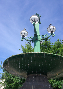
Photograph - Colour, Burke and Wills Fountain, Sturt Street Gardens, 2011, 29/12/2011
Colour photographs of the Burke and Wills Fountain in Sturt Street Balllarat.Plaque "Robert O'hara Burke, Leader. Died 30th June, 1861. William John Wills, Second. Died 30th June, 1861. Ludwig Becker, Naturalist. Died 29th April, 1861. Charles Grey, Assistant. Sied 17th April, 1861."burke and wills, burke and wills memorial, sturt street, ballarat, explorers, john king, robert o'hara burke