Showing 285032 items matching "streets,roads,melbourne,map,melway"
-
 Greensborough Historical Society
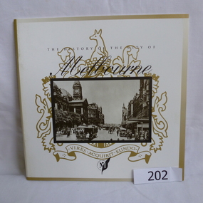
Booklet, The History of the City of Melbourne, 1997_11
The history of the Melbourne City councilHistorical notes on the foundation of Melbourne and the creation and growth of the Melbourne Cricket Club.44 page booklet, printed in black and white, illus., maps. With gold highlighting on the outer coversNilmelbourne settlement, melbourne landsales, melbourne local government, john batman, john pascoe fawkner -
 Melbourne Tram Museum
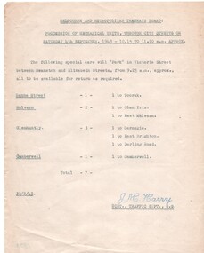
Document - Notice, Melbourne & Metropolitan Tramways Board (MMTB), "Procession of Mechanical Units, Through City Streets", 30/08/1943 12:00:00 AM
... "Procession of Mechanical Units, Through City Streets" ...Set of two Typed quarto sheets, MMTB Notice, re processions through city streets of army or military units during 1943 - gives times, special cars need and where they were to be parked in Victoria St and destinations. Signed by J. M. Harry, District Traffic Superintendent using a rubber stamp. .1 - Mechanical units - 4/9/1943 - 7 trams - dated 30/8/1943 trams, tramways, mmtb, world war 2, parades, swanston st, victoria st -
 Queenscliffe Maritime Museum
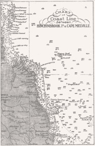
Map - B & W coastal map of Hinchinbrook Island to Cape Melville in Queensland, Coastal map Queensland Hinchinbrook Is to Cape Melville, Before donation in 1987
Australian coastal mapsAustralian coastal mapsMap from unknown book of Queensland coast Hinchinbrook Island to Cape Melville, pre 1987Reverse " NIL "old maps of australian coast -
 Stawell Historical Society Inc
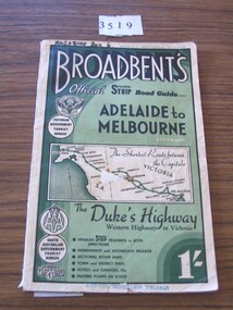
Book, Broadbent directory, Broadbent's Official : Speedo Strip Road Guide, 1943
Maps and descriptions of towns on the Western Highway & Dukes Highway from Melbourne to Adelaide. Sponsored by R.A.C.V and The Victorian Government Tourist BureauCream paper cover back border with green filling with a map from Melbourne to AdelaideBroadbeants Official Speedo Strip guide Melbourne to Adelaidestawell transport -
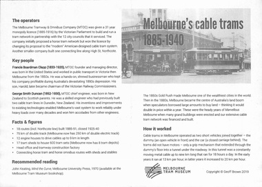 Melbourne Tram Museum
Pamphlet, Melbourne Tram Museum, "Melbourne' cable trams 1885-1940", 2019
Pamphlet, one fold, titled "Melbourne' cable trams 1885-1940", created by Geoff Brown for a tour of cable tram buildings for his Probus group on 6 Feb 2019. Has a map showing the Melbourne Cable Tram Network and a brief history of the cable tram network.trams, tramways, melbourne, map, routes, cable trams -
 Federation University Historical Collection
Document, Sandhurst Roads, 1856-7, 1856-7
... Sandhurst Roads, 1856-7 ...Blue Foolscap printed Government document relating to the Sandhurst (Bendigo) Roads.sanhurst roads, bendigo roads, w.h. pettitt, w. collier, j. collier, robert c. carr -
 Ringwood and District Historical Society
Map, Commonwealth Department of Defence, Military Survey map of Ringwood, 1916, Jun-16
Map prepared by Commonwealth Section Imperial General Staff given to Ringwood Historical SocietyMilitary Survey map of Ringwood +Additional Keywords: Hutchins,LL.Hutchins, 16 King's Rd. Marysville 3779. Received by postpak -
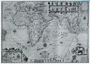
 Ballarat Heritage Services
Map, Map Published at Paris, 1587, 1527
This map shows a portion of New Guinea, but the plae occupied by Austrlai was left as open ocean.Copy of a map from 'A Short HIstory of Australia' by Ernest Scott.map, paris map, new guinea, early australian mapping -
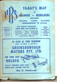 Greensborough Historical Society
Map, To-day's Map of Ivanhoe - Heidelberg; including Rosanna, McLeod, Watsonia, Greensborough to Eltham, 1937-1953
Map of the suburbs of Ivanhoe, Heidelberg, Rosanna, Macleod, Watsonia, Greensborough and Eltham. Dates to mid 1950s. An Advertiser on this map may be found in the Hurstbridge Advertiser Friday 17 December 1937, page 7: "Lyon Bros, of Eltham garage, suggest in their advertisement on the front page of this issue. that motorists should have their cars checked over by them before Christmas, so that any 5mall defects which might militate against the pleasure of the trip, might be remedied." As does "The Montsalvat Plant Farm" in The Age of Saturday 5 September 1953, page 48.Shows early streets and open space in these areas.Fold out map in pale blue cover. Cover dimensions: 21.5x15cm. Map is surrounded by advertising for local businesses.ivanhoe, maps, heidelberg, rosanna, macleod, watsonia, greensborough, eltham -
Whitehorse Historical Society Inc.
Map, before 1890
Early map showing location and areas of plots and their owners' names between Heatherdale Road in the east and Springvale Road in the west, Burwood Road to the south to north of Canterbury Road. Later additions to 1969Early map showing location and areas of plots and their owners' names between Heatherdale Road in the east and Springvale Road in the west, Burwood Road to the south to north of Canterbury Road. Later additions to 1969Early map showing location and areas of plots and their owners' names between Heatherdale Road in the east and Springvale Road in the west, Burwood Road to the south to north of Canterbury Road. Later additions to 1969mitcham, vermont, nunawading -
Surrey Hills Historical Society Collection
Map, Contour map of Surrey Hills showing potential sites for the Telecom Tower
The PMG / Telecom / Telstra tower was built in 1961-1963 as a relay station to support television and radio links between city and regional broadcasting stations. The tower itself was 45 m in height with a 2 storey building for equipment and staff surrounded by garden. From the beginning it was opposed by local residents. The location is said to be the second highest site in Melbourne, sometimes described as Delaney's Hill.Two A3 photocopied sheets of a map showing part of Surrey Hills, roughly between Windsor Crescent and Belmont Street (north / south) and Standard Avenue and Balmoral Crescent (east / west). The map shows contour lines and house sites, 16 of which are numbered. One sheet has been inscribed in top RH corner with notes regarding the significance of the numbers."Contour map of potential sites / for the telecommunications tower which / was eventually sited at 2. / Jock Campbell OBE was our neighbour / at 4 Theodore St when we moved into / the area in 1984. He was responsible in his / job at the PMG in deciding on the /site of the tower - Note site 5 was / behind his (& our) house. / Jack ended his career as Deputy Director / of the PMG. He sat on international committees / after WW2 to decide the split of the electronic / spectrum for radio, TV etc. / His group developed a "mobile phone" using / fixed towers but the phone was a truck full of gear."contour map, telecom tower, maps, jock campbell, john duncan campbell -
Port Melbourne Historical & Preservation Society
Education kit, Port Melbourne City Council, Port Melbourne - Our City, Our Life, Our Choice - No Amalgamation, Jun 1986
Port Melbourne - Our City, Our Life, Our Choice - No Amalgamation Facts and figures for the poll kit local government - city of port melbourne, amalgamation, frederick charles jackson, town clerks, liana thompson, mayors -
Melbourne Tram Museum
Document - Digital Image, Public Transport Victoria (PTV), "Swanston and Victoria Streets Precincts upgrade", 2/2024
... "Swanston and Victoria Streets Precincts upgrade" ...Information / consultative document about possible changes to tram tracks at the corner of Swanston and Victoria Streets and Elizabeth and Victoria Streets Melbourne. Shows the proposed new park around the former Franklin St signal box, new curves, reconstructed and extended tracks, car parking and traffic changes. Notes the potential of connecting North Melbourne (Arden precinct) to Swanston StYields information about a possible project at Swanston and Victoria Streets.Digital Image of a two-page A4 information document down loaded 31/3/2024 titled "Swanston and Victoria Streets Precincts upgrade" from https://yarratrams.com.au/media/p2rbhmin/community-update-swanston-and-victoria-streets-precinct-upgrade.pdf See item 7624 for PTV works notice.proposed works, swanston st, franklin st, victoria st, elizabeth st, trackworks, consultation -
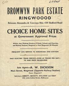 Ringwood and District Historical Society
Flyer, Bromwyn Park Estate, Ringwood - 1946 - Avertising Brochures and Map
Two pages of subdivision features, services and locationSubdivision plan includes Alexandra Road, Marwarra Street, Tooronga Road, Hilary Grove, Morcom Avenue. -
 Bacchus Marsh & District Historical Society
Map, Mouyong Parish Map, County of Grant
A single page paper map showing the map for the Parish of Mouyong in the County of Grant. Cadastral map showing land ownership. The map is pasted into a bound volume containing 76 maps or plans in total. High resolution digital image stored on BMDHS computer network. Photo lithographed at the Department of Lands and Survey Melbourne by T. F. McGauran, 9. 4. 07mouyong parish plan, mouyong parish maps, bacchus marsh region parish plans -
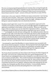 Greensborough Historical Society
Folder, Hume Street Improvement Committee, 1958_
The Hume Street Improvement Committee was one of several 'progress associations' in the Greensborough area at the time the area was being urbanised. A typed page explains the concerns of residents when the street was being paved. Includes photographs and maps of area.These documents are concerned with the urbanisation of Greensborough in the mid 20th century while residents tried to maintain the rural feel of the area.Foolscap manilla folder containing various lists, maps and photographs.On cover "Hume Street Improvement Committee/ spare circulars/maps"greensborough, road making, brian roberts, hume street improvement committee, briar hill -
 Phillip Island and District Historical Society Inc.
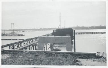
Photographs, Country Roads Board, Phillip Island 2nd Bridge Construction, 1966 - 1969
... Country Roads Board ...Fifteen photographs from a collection of 70 taken at the construction of Phillip Island 2nd Bridge from 1966 - 1969 by Country Roads Board and Shire of Bass. Contractor John Holland & Co Pty Ltd.Fifteen Black & White photographs of the construction of the Phillip Island 2nd Bridge from 1966 - 1969 by Country Roads Board. Various photos of materials, machinery and people involved in the construction.351-50: CRB NEG No. 66-2860G. 351-51: CRB NEG No. 67-2866. 351-52: CRB NEG No. 67-2867B. 351-53: CRB NEG No. 66-2958A. 351-54: CRB NEG No. 66-2958B. 351-55: CRB NEG No. 67-3070E. 351-56: CRB NEG No. 67-3070F. 351-57: CRB NEG No. 64-3280B. 351-58: CRB NEG No. 67-3356G. 351-59: CRB NEG No. 66-3462D. 351-60: CRB NEG No. 66-3465G. 351-61: CRB NEG No. 66-3466D. 351-62: CRB NEG No. 67-3535D. 351-63: CRB NEG No. 67-3535H. 351-64: CRB NEG No. 67-3535M.phillip island 2nd bridge construction, phillip island bridge (1969), country roads board, shire of bass, john holland & co pty ltd, sasha stark -
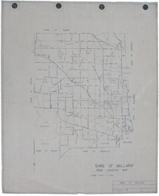 Federation University Historical Collection
Map, Shire of Ballarat Road Location Map, 1968, 05/06/2014
... roads ...White paper road location map. Scale 1 mile to 1 inchballarat, shire of ballarat, roads, dowling forest, lake burumbeet, lake learmonth, ascot, windermere, tourello -
Federation University Historical Collection
Document, Roads and Works in Grenville and Polworth, 1856, 1856
... Roads and Works in Grenville and Polworth, 1856...roads ...Blue Foolscap printed Government document relating to roads and works in Grenville and Polworth. roads, grenville, polworth -
 Ballarat Heritage Services
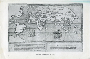
Photograph - Map, Robert Thorne's Map, 1527, 1527
This map serves the purpose of proving that Thorne and the Spanish geographers knew nothing about a continent near Australia.Copy of a map from 'A Short HIstory of Australia' by Ernest Scott.map, robert thorne, robert thorne's map, spanish explorers -
 Ballarat Heritage Services
Map, Plancius's Map (Amsterdam), 1594, 1594
Copy of a Dutch map published in Amsterdam. showing a large stretch of outhern land called Terra sustralis Copy of a map from 'A Short HIstory of Australia' by Ernest Scott.map, plascius, placius's map, terra australis, dutch map -
 Bendigo Military Museum
Poster - Map Production flow chart poster using Automap 2, Army Survey Regiment, Bendigo, 1982
This poster designed to be folded into a brochure describes the second phase of the computer assisted cartographic system to be used by the Royal Australian Survey Corps in the establishment of a topographic data base, Future tactical applications and map products using the data base are displayed. A topographic map of Series R631 1:100,000 Helenvale, Queensland printed on the reverse side that was produced by the Automap system using information from the topographic data base. This is the fifth edition of the poster.A multi colour poster of map production using the Automap 2 system. Poster shows a schematic and pictorial flow chart diagram of the stages of the map production process using the Automap 2 system. The poster was intended to be folded into a small brochure. A 1:100,000 Army Survey Map Series R631, 7966 Helenvale, Queensland Edition 2 is printed on the reverse side of the poster. The map is an example of one of the initial maps produced on the Automap 2 System at the Army Survey Regiment, Bendigo.royal australian survey corps, rasvy, fortuna, army survey regiment, army svy regt, asr, automap 2 -
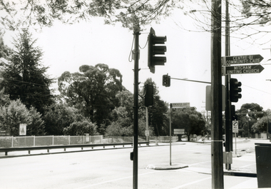 Whitehorse Historical Society Inc.
Photograph, Corner Doncaster East & Mitcham Roads, 2000
... Corner Doncaster East & Mitcham Roads ...Produced as one of a series of 24 prints commissioned by Nunawading & District Historical Society -|Theme: Intersections of Mitcham and Nunawading 2000/2001.|See also Series by P. Simmenauer on the same theme.Black and white photograph - print and negative of Corner of Doncaster East and Mitcham Roads facing grounds of Mitcham Primary School. Note road and street signage: Doncaster East Road; Mitcham and District Private Hospital; Centre of Community Care; Mitcham Uniting Church. (See also NP2324)doncaster east road mitcham, mitcham road, mitcham, mitcham primary school no. 2904, street signs -
Port Melbourne Historical & Preservation Society
Letter, Port Melbourne City Council, Port Melbourne - Our City, Our Life, Our Choice - No Amalgamation, Jun 1986
Port Melbourne - Our City, Our Life, Our Choice - No Amalgamation Letter from Liana Thompson (Mayor) local government - city of port melbourne, amalgamation, liana thompson, mayors -
Port Melbourne Historical & Preservation Society
Document, Port Melbourne City Council, Port Melbourne - Our City, Our Life, Our Choice - No Amalgamation, Jun 1986
Port Melbourne - Our City, Our Life, Our Choice - No Amalgamation yellow sheet with process for signature collection local government - city of port melbourne, amalgamation, frederick charles jackson, town clerks, liana thompson, mayors -
Whitehorse Historical Society Inc.
Map, This is Vermont, 1895-1920?
'Now you have seen it, tell your friends''Now you have seen it, tell your friends' - hand-drawn map of Vermont from Springvale Road to Heatherdale Road, showing the names of owners of houses, main roads and streets, shops and schools.'Now you have seen it, tell your friends' vermont south, vermont, roads and streets -
 Ringwood and District Historical Society
Photograph, South-western view from Marcel Street North Ringwood over Jull Parade to Oban Road - 1981. North Ringwood Sports Reserve is on the left, above the corner of Jull and Oban Roads
... is on the left, above the corner of Jull and Oban Roads. ...Writing on back of photograph reads, "E620. N1. 1981. Looking south-west from Marcel Street North Ringwood over Jull Road to Oban Road. North Ringwood Sports Reserve centre left above corner of Jull and Oban Roads". -
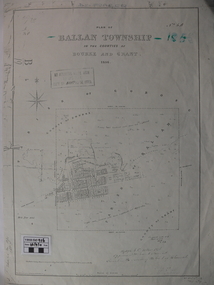 Ballan Shire Historical Society
Map - Map. Ballan Township, Plan of Ballan Township in the Counties of Bourke and Grant
The map is an early one of the township of Ballan showing street names and land owners.The map is significant in that it lists the owners of the house blocks within the township.A map showing the township and surrounding area of Ballan in 1856. Town streets are named as are the owners of the subdivided blocks of land. The map is a lithocopy and there is a scale in chains."D D Fraser" is written across the top of the map and "1856" is written in the near top right corner. There are other additions to the map but they are very difficult to decipher accurately or completely.ballan, ballan township map, ballan1856 -
 Marysville & District Historical Society
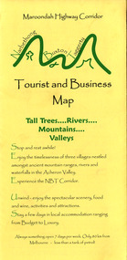
Map (Item) - Tourist and business map, Narbethong Community and Tourism Group, Narbethong Buxton Taggerty Tourist and Business Map, 04-2008
A tourist and business map of Narbethong, Buxton and Taggerty. This map was produced by the Narbethong Community and Tourism Group in April 2008. It was produced to promote the natural attractions, adventure activities and food trail from the Black Spur, through Narbethong, Buxton and Taggerty.A tourist and business map of Narbethong, Buxton and Taggerty.This publication has been produced by the Narbethong Community and Tourism/ Group (NCTG) to promote the natural attractions, adventure activities and food/ trail from the Black Spur, through Narbethong, Buxton and Taggerty./ the information provided in this publication has been supplied by the individual/ members. NCTG takes no responsibility for its accuracy./ April 2008narbethong, buxton, taggerty, victoria, australia, tourist and business map, narbethong community and tourism group, acheron valley, yarra track, wood's point, black spur, mystic mountains, the meeting of the waters, cathedral range, danico design counted cross stitch, things of sand & stone, buxton zoo nursery & oddz & enz, willowbank at taggerty, safe trek 4wd services, pnl 4wdriving, buxton trout and salmon farm, mystic mountains ski hire & outdoors, narbethong ski hire, highwood health centre, cathedral view natural therapies, narby cabinets, plants by shelian, gb timber, executive signs, rb automotive repairs, buxton car care, marysville towing & equipment hire, martyn slade building design, cathedral peak framing, black spur roadhouse & ski hire, tudor lodge roadhouse & ski hire, buxton roadhouse & persian bazzar, buxton post office general store & niche bar, igloo roadhouse, taggerty store, narby eggs, marapana agistment park, mantirri blueberry farm, carmyle farm, hazelwood hazelnuts, south cathedral lavender farm, cathedral cherries, black spur motel & caravan park, woodlands rainforest retreat, chestnut glade, black spur inn, wombat cottage, abbey lake luxury b & b spa cottages, blue views holiday cottages, camp narbethong, marapana farm stay b & b, mantirri blueberry farm b & b, little dene garden cottages, silverstream b & b cottages, nareen cabins, moondai farm b & b, south cathedral farm luxury b & b cottages, yarrolyn caravan park, sarsens rest, lomah retreat, pinjarra gardens, kingbilli country estate, henry viii manor house, buxton hotel, butters cafe of buxton, wagtail wines, little river wines, lanterns at willowbank, wirrawilla rainforest walk, wilhemina falls, the cascades -
 Marysville & District Historical Society
Map (Item) - Tourist and business map, Narbethong Community and Tourism Group, Narbethong Buxton Taggerty Tourist and Business Map, 04-2008
A tourist and business map of Narbethong, Buxton and Taggerty. This map was produced by the Narbethong Community and Tourism Group in April 2008. It was produced to promote the natural attractions, adventure activities and food trail from the Black Spur, through Narbethong, Buxton and Taggerty.A tourist and business map of Narbethong, Buxton and Taggerty.This publication has been produced by the Narbethong Community and Tourism/ Group (NCTG) to promote the natural attractions, adventure activities and food/ trail from the Black Spur, through Narbethong, Buxton and Taggerty./ the information provided in this publication has been supplied by the individual/ members. NCTG takes no responsibility for its accuracy./ April 2008narbethong, buxton, taggerty, victoria, australia, tourist and business map, narbethong community and tourism group, acheron valley, yarra track, wood's point, black spur, mystic mountains, the meeting of the waters, cathedral range, danico design counted cross stitch, things of sand & stone, buxton zoo nursery & oddz & enz, willowbank at taggerty, safe trek 4wd services, pnl 4wdriving, buxton trout and salmon farm, mystic mountains ski hire & outdoors, narbethong ski hire, highwood health centre, cathedral view natural therapies, narby cabinets, plants by shelian, gb timber, executive signs, rb automotive repairs, buxton car care, marysville towing & equipment hire, martyn slade building design, cathedral peak framing, black spur roadhouse & ski hire, tudor lodge roadhouse & ski hire, buxton roadhouse & persian bazzar, buxton post office general store & niche bar, igloo roadhouse, taggerty store, narby eggs, marapana agistment park, mantirri blueberry farm, carmyle farm, hazelwood hazelnuts, south cathedral lavender farm, cathedral cherries, black spur motel & caravan park, woodlands rainforest retreat, chestnut glade, black spur inn, wombat cottage, abbey lake luxury b & b spa cottages, blue views holiday cottages, camp narbethong, marapana farm stay b & b, mantirri blueberry farm b & b, little dene garden cottages, silverstream b & b cottages, nareen cabins, moondai farm b & b, south cathedral farm luxury b & b cottages, yarrolyn caravan park, sarsens rest, lomah retreat, pinjarra gardens, kingbilli country estate, henry viii manor house, buxton hotel, butters cafe of buxton, wagtail wines, little river wines, lanterns at willowbank, wirrawilla rainforest walk, wilhemina falls, the cascades