Showing 446 items matching "water garden"
-
 City of Kingston
Photograph - Colour, Circa 1993
Edithvale is a suburb in the City of Kingston. It is located between Aspendale and Chelsea on the Port Phillip Bay and built within remnant areas of the Carrum Carrum swamp. The foreshore precinct comprises a wide sandy beach, with low sand dunes and numerous historic boat sheds. The suburb consists of older style dwellings and former holiday houses, combined with mid-century housing and newer homes. The large blocks are increasingly subdivided and the existing dwellings demolished to accommodate units and townhouses, thus changing the landscape of the area and reducing the tree canopy.The beachside suburb of Edithvale was previously part of the extensive Carrum Carrum Swamp. The area was once a source of fish and eels for the Mayone-Bulluk clan of the Bunurong people. Over time the area was drained and predominantly devoted to dairy farming and holiday houses. The farms were gradually sold and subdivided with a large number of homes built after World War II and in the 1960s. Edithvale is mainly residential with a shopping strip along Nepean Highway but little significant industry was ever established in the area apart from a plaster works and confectionary factory, both now closed.Aerial colour photograph of Edithvale as viewed from Alexandra Avenue in the north to Ella Grove Chelsea/Edithvale in the south. The area is built-up with residential housing and facilities including Edithvale Primary School, numerous churches and the Edithvale Railway station. Large sections depict the remnant Carrum Carrum swamp. Edithvale Common and the former "Duck Inn" (Melbourne Water/Friends of Edithvale Seaford Wetlands) can be seen. Edithvale Recreational reserve, the velodrome and Edithvale Public Golf Course are prominent. The image shows vacant land in the area now known as Aspendale Gardens and the newer residential section of Chelsea Heights is not developed. A bike path has been established to cover the secondary drain. The Golf Links Court residential development located off Hughes Avenue is a large vacant block.Yellow circular adhesive sticker on plastic Black ink (marker): * (asterisk) Black type on white adhesive sticker: P000108edithvale, aspendale, chelsea, carrum carrum swamp -
 University of Melbourne, Burnley Campus Archives
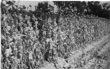
Album - Black and white prints and negatives, James Leslie Provan, Photograph Collection, 1940-1950
... parsnips school of horticulture burnley gardens beetroot hoeing ...Collection of 39 black and white photographs. Some photographs with handwritten annotations in what looks like the handwriting of J.L. Provan. Mostly at Burnley, some at Moorabbin. (1) "Opium Poppy 1942 Burnley. Publicity Branch Department of Agriculture." Negative in envelope marked, "Prints 1 of No. 398 Department of Agriculture 'McP.' " (2) Grape vine and cabbages. (3) Rows of seedlings in the Orchard. (4) Orange tree? unpruned. (5) Flowers. (6) "Double and single rows of French Beans." (7) "Sage & marjoram." (8) Hydrangeas. (9)Sprinkler on newly planted cabbages. (10a)"Lettuce Iceberg 1/1/43." Seeds on soil surface. (10b) "Lettuce Iceberg 1/1/43." Seedlings emerging. (11)? planted in terracotta pipes. (12) Rows of seedlings in the Orchard. (13) "A student sowing Parsnip seed in a drill row. School of Horticulture Burnley Gardens." (14) Student distributing fertilizer? (15) Similar. (16) Similar. (17a) Flowers. (17b) Flowers. (18)"Beetroot Crimson Globe." (19) A seed drill. (20)Canna. (21a) Vegetable rows. (21b) ? (22) Student hoeing. (23) Student hoeing. (24) Similar. (26) "Cabbage Burbees Allhead 2/2/43," seedlings. (27) Water, manure, etc. (28) "Celery beds Ray Marriott Moorabbin April 2nd 1943." (29-37) Also at Moorabbin probably: (29) Vegetables. (30) Onions. (31) Vegetables. (32) Planting seedlings. (33) Vegetables. (34) Celery, carrots, turnips on display. (35) Carrots growing and just pulled up. (36) Peas. (37) Ploughing with horse. (38) Student spraying vegetables at Burnley. (39) House?j.l. provan, burnley, moorabbin, opium poppy, grape vine, cabbages, seedlings, orchards, orange trees, flowers, french beans, sage, marjoram, hydrangea, sprinkler, lettuce iceberg, seeds, students sowing, parsnips, school of horticulture burnley gardens, beetroot, hoeing, water, manure, celery, vegetables beds, ray marriott, onions, carrots, turnips, peas, ploughing, horse, spraying -
 Bendigo Historical Society Inc.
Document - MINING REPORTS - KENTISH MINE MANAGER'S REPORT
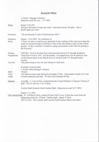
Here on the Garden Gully Line were Bell and Watson’s, the Cornish United, the Victory and George Lansell’s pride, the Pandora. Here too, was the enormously rich Kentish Mine from which its owner, J.B.Watson, was credited with taking some thirteen tons of gold, then worth £1,500,000. At this time, John Boyd Watson was well on the way to becoming not only the richest man in Sandhurst, but probably in the colony. (Extract from North West Victoria Historic Mine Sites, David Bannear, Heritage Victoria, 1991.)Handwritten extracts by Albert Richardson, with typed copy of same, from the Kentish Mine Manager, J. J. Jewell's Report. Extracts dated 1-11-1894 and 9-3-1894. Report mentions crushings and gold yield at the Old Carlisle Shaft and crushings and gold yield from The 'Central' mullock. (b) mentions the baling of water and the Carlisle Shaft, formerly Nth Garden Shaft.document, gold, mining reports, mining reports, kentish mine manager's report, j j jewell, old carlisle shaft, w griffiths & party, nth garden shaft, j cock & party, the 'central' -
 City of Greater Bendigo - Civic Collection
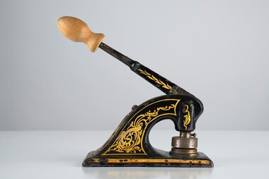
Ceremonial object - Common Seal
Bridgewater is a situated 39km northwest of Bendigo and 170 km from Melbourne. It was established as a crossing point over the Loddon River for gold diggers en route to the Inglewood gold diggings. As gold began to dry up in the district the town of Bridgewater developed due to its proximity to the river which it relied on for industries such as brewing, farming and market gardens. As demand on the water supply grew, the Water Works were established to ensure supply and manage the quality of the water for drinking. Decorated hand operated cast iron embosser with 40mm seal head attached. Gold and orange painted decorations extend from top edge of handle to sides of base. Original knob has been replace with a newer wooden knob. Well used showing all over signs of wear. Seal is for the Bridgewater Waterworks Trust 1927.Bridgewater Waterworks Trust 1927.loddon shire -
 Tatura Irrigation & Wartime Camps Museum
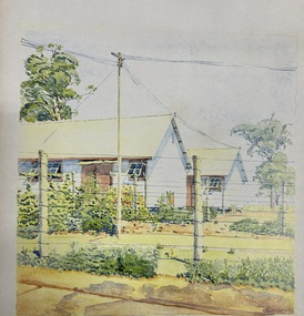
Painting - Painting - Water Colour, Camp 3, 1942
Original water colour painted by Glunkler an internee at Camp 3Hoefer Familywatecolour of camp 3. 2 half huts half obscured, 2 posts, 9 wire strand fence with an electric powerline. Tall gum tree left hand side, gardens. I. (Note : Glass windows had replaced fly wire by 1941 in the huts.) Glunkler 42painting, watercolour, huts, glunkler, hoefer family, camp 3, tatura, ww2 camp 3, illustrations -
 Warrnambool and District Historical Society Inc.
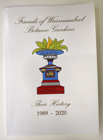
Book - History of Friends of Warrnambool Botanic Gardens, Marie Johnstone and Pat Varley, Friends of Warrnambool Botanic Gardens - Their History 1989-2020, 2022
Friends of Warrnambool Botanic Gardens historyThis is a book of 48 pages. The cover is white with a colour image of a water fountain. The pages contain printed text and small images of the front cover fountain.non-fictionFriends of Warrnambool Botanic Gardens historywarrnambool botanic gardens, history of warrnambool gardens, friends of warrnambool gardens -
 Eltham District Historical Society Inc
Film - Video (VHS), Nillumbik Shire Council, The Nillumbik Story, 1996
PART 1 – NILLUMBIK (00:00-07:17) Opening features various scenes around Nillumbik Shire. For 40,000 years Nillumbik was the home of the Wurundjeri people. Robert Hoddle gave the district its name. Jock Ryan, then president of Nillumbik Historical Society discusses the names Nillumbik and Diamond Creek. In the late 1830s white occupation began with gold found in Warrandyte in 1851 and 12 years later at Diamond Creek -the Diamond Reef which led to the Caledonian gold rush. Jock Ryan discusses the Diamond Creek mine, which was thriving until it burnt out in 1915. Large numbers of workmen moved into area in late 1870s to construct the Maroondah Aqueduct. With growing population of Melbourne, the nearby Yan Yean system had severely disrupted the flow of the Plenty River, forcing the closure of three flour mills there. The aqueduct came to the rescue carrying water 66km from Healesville to Preston. When the Diamond Creek gold mine burnt down the local economy suffered but fruit growing industry had already been established and Diamond Creek became a thriving fruit growing centre. Interview with Jack Powell, a long-time fruiterer at St Andrews market, his family had lived in the area for a hundred years, 3 to 4 generations, “a lot of hard work”. By the time the railway arrived fruit growing was no longer competitive. The railway brought the city closer and day trippers. The Green Wedge separates the shire from the more densely developed neighbours such as Whittlesea, Doncaster, Templestowe, Bulleen and Greensborough. Population at the time (1996) was 19,000 but links to the past remain strong. Mudbrick houses along the Heritage Trail The saving of Shillinglaw Cottage from demolition in 1963 and relocation brick by brick. PART 2 – ENVIRONMENT (07:18-14:44) Peter Brock (with Bev Brock in background) at St Andrews market discusses his childhood growing up in the district and the environment and the values it instilled upon him and his own family. The Brocks have been in the district since the 1860s. Nillumbik Shire responsible for managing three catchment areas; Diamond Creek, Arthurs Creek and Watsons Creek. Follows the course of the Diamond Creek commencing in Kinglake through the district to its confluence with the Yarra River at Eltham at Eltham Lower Park. Highlights Eltham Lower Park community revegetation program and the newly constructed (1996) viewing platform built of new and recycled timbers at the confluence of the Diamond Creek and Yarra River. Also featured are outdoor recreation on the river and at Eltham Lower Park including the Diamond Valley miniature railway. Sugarloaf reservoir and recreational activities and fishing. Aerial view of Memorial Park and Shire of Eltham War Memorial tower at Garden Hill, Kangaroo Ground. Significant tourism opportunities for the shire with 3 million potential day-trippers in metropolitan Melbourne. Council and community working together to find a way to promote the shires natural and artistic assets. At Arthurs Creek, the Brock family and neighbours working together to take care of their waterway. Peter Brock’s uncle, Sandy Brock talks about environmental management and the Arthurs Creek Landcare group and actions to eradicate blackberry problem. Having previously planted Cypress rows they are replacing them with indigenous species to improve the water supply, keeping cattle out of the creek bed to improve the quality downstream flowing into the Yarra. Eltham East Primary School Band playing “All things bright and beautiful” merges into scenes of the bushland sanctuary set aside by the school in 1980 with unidentified teacher discusses the sanctuary and their education program and school children’s comments. Plight of a family of Wedgetail eagles nesting in the path of a developer’s bulldozer at North Warrandyte and actions to save their nesting areas. PART 3 – ARTS (14:45-22:00) Arts and Jazz festival at Montsalvat featuring interviews with Sigmund Jorgensen discussing Montsalvat and its principles. Also Matcham Skipper. Clifton Pugh’s funeral at Montsalvat and his legacy at Dunmoochin near Cottlesbridge with artists in residence, at the time, Chicago artist Charles Reddington who discusses the benefits of the experience. An unidentified female artist also talks about the program and why people are drawn to the area. Unidentified man on street talking about the amount of talent in the area, artists, poets, musicians, authors. Artist Ming Mackay (1918-2009) interviewed talking about the people she mixes with on “the Hill”. Works of local artists are displayed Eltham Library Community Gallery and Wiregrass gallery with a new coffee shop at the Wiregrass making it an even more popular destination. Music at St Andrews Hotel (may be a little bit country) and the Saturday market where likely to hear anything. Sellers and patrons at the market asked about what attracts them to the market and where they came from. Scenes of poets/authors giving readings. CREDITS Music by John Greenfield from the CD Sweet Rain “The Snow Tree”, Uncle Music UNC 2001 Cameras - David Mirabella and Peter Farragher Editor – Olwyn Jones Written and Produced by Jason Cameron A Jason Cameron Proction for Nillumbik ShireProvides a record of the relatively newly created Shire of Nillumbik at the time and the features and attactions of the shire in its people arts, culture and environmentVHS Cassette (five copies) DVD (one copy) Converted to MP4 file format 0:22:00, 1.60GBvideo recording, arthurs creek, arthurs creek landcare group, artists, artists in residence, arts, arts festival, authors, blackberry, brock family, bulldozer, bulleen, bushland sanctuary, caledonian gold rush, charles reddington, clifton pugh, cottlesbridge, cypress rows, developer, diamond creek, diamond creek mine, diamond reef, diamond valley miniature railway, doncaster, dunmoochin, education program, eeps, eltham, eltham east primary school, eltham east primary school band, eltham library community gallery, eltham lower park, environment, fishing, flour mill, fruit growing, fruiterer, garden hill, gold mining, green wedge, greensborough, heritage trail, hurstbridge railway line, jazz festival, jock ryan, kangaroo ground, kangaroo ground tower, kinglake, maroondah aqueduct, matcham skipper, memorial park, ming mackay (1918-2009), montsalvat, mudbrick houses, music, musicians, nesting area, nillumbik historical society, nillumbik shire, north warrandyte, old timer, orchards, peter brock, plenty river, poets, population, recreation, recreational activities, revegetation, robert hoddle, sandy brock, shillinglaw cottage, shire of eltham war memorial, sigmund jorgensen, st andrews hotel, st andrews market, sugarloaf reservoir, templestowe, the hill, tourism, viewing platform, warrandyte, water catchment area, watsons creek, wedgetail eagle, whittlesea, wiregrass gallery, wurundjeri, yarra river, jack powell -
 Wodonga & District Historical Society Inc
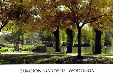
Photograph - Eric Sumsion Gardens
Mr Eric Sumsion was the gardening curator for Wodonga Shire in 1956. He had previously operated a bootmaker’s shop in High Street, Wodonga for many years. Eric saw the potential of the area in Wodonga now known as Belvoir Park and asked permission to work on part of the area. He eventually purchased a house adjoining the area giving him more time and easy access to work on it. The Lagoon, Lake Huon, Belvoir Lagoon, Belvoir Park and Sumsion Gardens are all names used over time for what is today one of Wodonga’s favourite recreation and picnic spots. In the 1800s river boats could enter Lake Huon from Wodonga Creek. There was a jetty south of where the water fountain is today. In later years, this jetty was used by the Clay Bird Shooting Club. From the early 1900s football and cricket were played there, and some mining leases were also allowed. At one time there were open gravel pits between House Creek and the main lagoon, and these were subsequently filled with town garbage collected by the Council. In the late 1940s, Wodonga Golf Club took over part of Belvoir Park for a 9-hole golf course with sand greens. The Golf Club House was built in 1946. The Club extended the course to 12-holes when the football ground moved to Martin Park and the course later extended to 18 holes. Under Eric Sumsion’s care the area became a magnificent area of parkland and curated gardens. After he had retired in 1961 his work was acknowledged by the Shire Engineer, Mr Bill Page, when the Sumsion Gardens were named in his honour. He was also responsible for the design and curating of many other gardens in Wodonga, including those at Sarah Coventry and Richardson Park. Eric Sumsion died in July 1988, aged 85.This item is significant because it acknowledges the dedication and commitment of Eric Sumsion to the Wodonga Community.A collection of photographic images and an advertisement related to the work of Eric Sumsion in Wodonga.eric sumsion, parks and gardens wodonga -
 Bendigo Historical Society Inc.
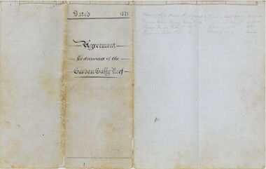
Legal record - Hartnell Legal Documents: Agreement for Drainage of the Garden Gully Reef 1871
Agreement and Subscription Schedule for Drainage of the Garden Gully Reef 1871 2 pieces of lined A3 paper folded to make a 4 page book bound with string. Document handwritten in black ink on blue lined paper with red margins. When closed the book was then folded in 4 to create a pamphlet. The document has extensive notes written in pencil, which are difficult to read. The document also has two water marks. On the cover page is a crest with the initials EE underneath. All other pages have the second which reads R. Barnard 1850. The document makes use of 2 types of seals, a red wax seal and a variety of stamps which indented the paper. The stamps read as follows: 1. Victoria Queen Quartz Mining Co. Registered Bendigo 1870 2. Garden Gully Reef Extended Co. Registered Bendigo. 3. (difficult to read) Sandhurst and Registered are visible. 4. The Premier Garden Gully Company Registered Sandhurst 5. The Queen of Sheba Tribute Co. Registered 1871 6. Victoria Queen Tribute Co. Registered Bendigo. 7. Cemetery Reserve Company Sandhurst Registered 1871 8. Premier Tribute Co. South Garden Gully Sandhurst.the bank of victoria, the victoria queen quartz mining company, jean baptiste loridan, john augustus woodward, the garden gully reef, garden gully reef extended co, victoria queen quartz mining co, the premier garden gully company, the queen of sheba tribute co, victoria queen tribute co., cemetery reserve company, premier tribute co. south garden gully -
 Bendigo Historical Society Inc.
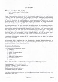
Document - MINING REPORTS - AIR BRAKES
Handwritten quote from W. Abraham, Inspl of Mines, Bendigo. He had been at the Great Northern Company's mine when the engine driver was hauling water from the 1.780 feet level, with a tank on one side and a cage on the other, broke the cross-head and two motion-bars; the drums reversed and desecended about 50 feet. The driver applied the air-brakes. The drums were brought a standstill, without any further damage. The Insp. Was in favour of the air -brakes and thought every should be compelled to use them in shafts below 1,000 feet in depth. Also a list of companies who have had these brakes fitted to their winding plants and a list of the companies who intend to fit them. Also mentioned is the price of fitting which was from 30 to 50 pounds.document, gold, mining reports, mining reports, air brakes, secretary mines report 1900 page 69, w abraham, great northern company, harkness & co, james mitchell, princess dagmar g m coy, confidence extended g m coy, victoria reef quartz coy, new moon g m coy, great southern garden gully g m coy, francis ormond g m coy chewton -
 Whitehorse Historical Society Inc.
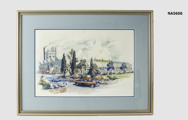
Painting - Water colour - Insulwool Factory
Insulwool Products Factory was on Whitehorse Road, Nunawading which closed in 1990 and now has Bunnings Warehouse. Insulwool became Boral Insulwool.Water colour painting of Insulwool Factory with landscape and garden. Has delivery truck and two cars in front. Gold frame with blue mount surrounds By C. Dudley Wood On back - the framing nook, 172 Canterbury Rd, Sth Blackburn, The Glen Shopping Centre, Glen WaverleyC. Dudley Wood & Insulwool Products Pty Ltdinsulwool factory, nunawading, c. dudley wood, painting -
 Bendigo Historical Society Inc.
Plan - MARKS COLLECTION: PLAN FOR FOUR LEVEL STAIRCASE TOWER TO GARDEN ELEVATION AT FORTUINA VILLA FOR GEO. LANSELL ESQ
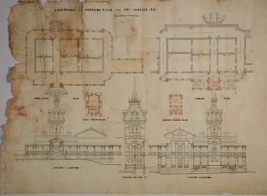
Fortuna Villa was owned from 1855 to 1871 by Christopher and Theodore Ballerstedt, Australia’s first mining magnates. In 1871 it was purchased by George Lansell (The Quartz King) being one of Australia’s most successful and adventurous nineteenth century gold mine owners and speculators. Lansell made numerous alterations and extensions to the building and it remained in the Lansell family until 1935.Plan for four level staircase tower to the Garden Elevation of Fortuna Villa, Sandhurst for George Lansell Esq. Plan details: * Plan shows ground, First, second and third floor plans for the staircase construction * First and second floor house plans and location of staircase addition * Front and Garden elevations with staircase addition Plan coloured and damaged on LHS, also with water damagebendigo fortuna villa, george lansell, building plans, c & t ballerstedt -
 Bendigo Historical Society Inc.
Plan - MARKS COLLECTION: PLAN GARDEN FRONT FORTUNA VILLA SANDHURST - G. LANSELL ESQ., JULY 3RD 1871
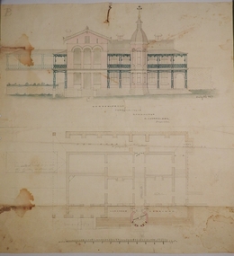
Fortuna Villa was owned from 1855 to 1871 by Christopher and Theodore Ballerstedt, Australia’s first mining magnates. In 1871 it was purchased by George Lansell (The Quartz King) being one of Australia’s most successful and adventurous nineteenth century gold mine owners and speculators. Lansell made numerous alterations and extensions to the building and it remained in the Lansell family until 1935. Plan for construction of Fortuna Villa, Sandhurst Title: Garden Front, Fortuna Villa, Sandhurst for G. Lansell Esq. Dated: 3rd July 1871 Coloured plan and elevation Condition: water damage and paper tearsfortuna villa, george lansell, c & t ballerstedt, building plans -
 Bendigo Historical Society Inc.
Document - MINING REPORTS - KENTISH MINE MANAGER'S REPORT
Handwritten extracts from the Kentish Mine Manager, J. Jewell's Report. Items mentioned are water baling, firewood, Robinson Street, sinking preparations, too hot to work, total depth of shaft, mullock and the Old Carlisle Shaft.document, gold, mining reports, kentish mine manager's report, j jewell, j cock & party, central mullock, carlisle shaft, north garden shaft, old carlisle shaft, w griffiths & party -
 Chelsea & District Historical Society Inc
Photograph - Chelsea Flood December 1934, Carrum Hotel, Nepean Highway
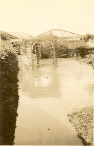
In December 1934, 700 houses were inundated with water, when the Dandenong Creek and Patterson River broke their banks.Black and white photo of flood waters in the garden of Carrum Hotel, showing an archway and in the background is a partially built building.flood, chelsea, dandenong creek, nepean highway, point nepean road, carrum hotel -
Bendigo Historical Society Inc.
Postcard - Postcards x 12
Colored postcards of Bendigo x 12 - Chinese Gardens, part of the Golden Dragon museum complex; Tourist Information Centre and Law Courts, formerly the old Post Office built 1887; Sunrise over Rosalind Park and the city of Bendigo; City Town Hall, begun in 1859; historic kilns at Bendigo Pottery; Water Pavilion, part of the Chinese Gardens section of the Golden Dragon Museum; Shamrock Hotel, built in 1897; shores of Lake Eppalock; view of View Street; glasshouse conservatory, part of Rosalind Park, Pall Mall; iron-work entrance to Rosalind Park conservatory; and interior of Sacred Heart Roman Catholic Cathedral of 1897.bendigo, gardens, chinese, pottery -
 Lakes Entrance Historical Society
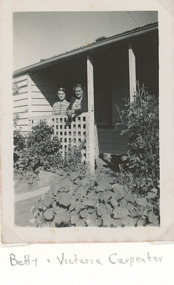
Photograph - Carpenter Family, Betty and Victoria Carpenter Lakes Entrance Victoria, 1950 c
at rear of Carpenter family home. Second photp showing tanks which collected drinking water for campers 04377.1Black and white photograph showing Betty and Victoria Carpenter Lakes Entrance Victoria. Also a black and white photograph of garden and pear tree at rear of Carpenter family homeNana and Betty at back door of old kitchen on reversegenealogy, houses, caravan parks, carpenter family -
 Lakes Entrance Historical Society
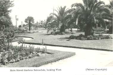
Postcard - Main Street gardens Bairnsdale Victoria, Bulmer, 1930 c
Black and white postcard with photograph of early Main Street gardens showing winding footpaths and palm trees and water tower and cenotaph in background Bairnsdale Victoria. plusTwo similar photographs of Bairnsdale gardens township, gardens -
 Lakes Entrance Historical Society
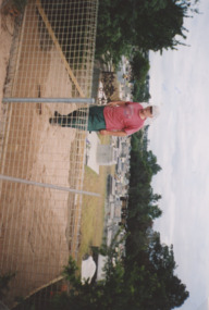
Photograph - Garden Cemetery Palmers Road Lakes Entrance Victoria, Lakes Post Newspaper, Don Brady, 2003
Colour photograph showing Don Brady in the area cleared for a large water tank to be filled by the Fire Brigade as a water supply for the Lakes Entrance Garden Cemetery Palmers Road Lakes Entrance Victoriacemeteries, water supply -
 Bendigo Historical Society Inc.
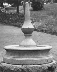
Photograph - FOUNTAIN ROSALIND PARK
Photo and negative of fountain - probably in Rosalind Park. Fountain made of granite, single upright set on round base. Appears that water would fountain from midpoint on upright. Garden beds and path in background. Note -Item is missing from folder .bendigo, buildings, fountain, rosalind park -
 Wooragee Landcare Group
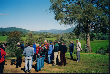
Photograph, 5 September 2004
This photograph was taken at Samaria Farm on Sunday the 5th of September as part of a day trip by the Wooragee Landcare Group. The event was about looking at land use on small farms and as a social get-together for the Group. Wooragee Landcare was also researching how small landholders could run some enterprises around the time of this trip. Samaria Farm is located in northeast Victoria, near Mount Samaria, which is located 130 km northeast of Melbourne. Samaria Farm was owned by Sue and Due Matheson at the time of the trip and had a renowned rose garden, pigs, poultry, alpacas, and goats on their nine-hectare farm. The rose garden consists of 3000 damask roses. Samaria Farm distils the oil from these roses and is the only farm in Australia to do this. Rose oil has historically been used for religious and medical use. 20 kg of rose buds are picked by hand every day, which is then distilled and produced 5 to 8 ml of oil. The entire four-week season produces 80 to 100 ml of oil. Rose water is also created during this process and produces about 300 litres per season. Along with the oil, the Farm also harvests lemons, lime, olives, and oranges. The Farm is currently owned by Utako and Anthony since 2022, with Vicki and Allan Wight being the previous owners. Wooragee Landcare Group was created in 1988. Its core mission is to work towards eradicating animals and pests from the land to protect the natural vegetation and promote revegetation projects. This photograph is a great example of the type of events that Wooragee Landcare Group has organized, while educating the public about the importance of land use management. The group is important to the community and for the environment.Landscape coloured photograph printed on gloss paperReverse: WAN NA E0NA2N2. NNN+ 2 4240/ [PRINTED] (No. 18) / 371samaria farm, wooragee, wooragee landcare group, wooragee landcare's collection, samaria, small farm, land use, social, rose oil, damask roses, pests -
 Wooragee Landcare Group
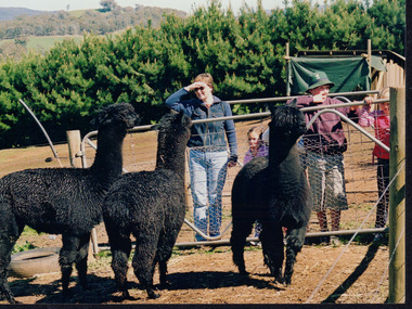
Photograph, 5 September 2004
This photograph was taken at Samaria Farm on Sunday the 5th of September as part of a day trip by the Wooragee Landcare Group. The event was about looking at land use on small farms and as a social get-together for the Group. Wooragee Landcare was also researching how small landholders could run some enterprises around the time of this trip. Samaria Farm is located in northeast Victoria, near Mount Samaria, which is located 130 km northeast of Melbourne. Samaria Farm was owned by Sue and Due Matheson at the time of the trip and had a renowned rose garden, pigs, poultry, alpacas, and goats on their nine-hectare farm. The rose garden consists of 3000 damask roses. Samaria Farm distils the oil from these roses and is the only farm in Australia to do this. Rose oil has historically been used for religious and medical use. 20 kg of rose buds are picked by hand every day, which is then distilled and produced 5 to 8 ml of oil. The entire four-week season produces 80 to 100 ml of oil. Rose water is also created during this process and produces about 300 litres per season. Along with the oil, the Farm also harvests lemons, lime, olives, and oranges. The Farm is currently owned by Utako and Anthony since 2022, with Vicki and Allan Wight being the previous owners. Wooragee Landcare Group was created in 1988. Its core mission is to work towards eradicating animals and pests from the land to protect the natural vegetation and promote revegetation projects. This photograph is a great example of the type of events that Wooragee Landcare Group has organized, while educating the public about the importance of land use management. The group is important to the community and for the environment. Landscape colored photograph printed on gloss paperReverse: WAN NA E0NA2N2. ANN+ 1 4240/ [PRINTED] (No. 19) / 372samaria farm, wooragee landcare group, wooragee, victoria, mount samaria, farming, roses, rose oil, damask roses, agriculture, pests, vegetation -
 Bendigo Historical Society Inc.
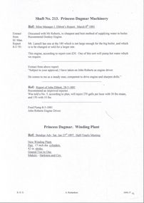
Document - MINING REPORTS - EXTRACTS FROM PRINCESS DAGMAR MINE MANAGER'S REPORT
Two copies of handwritten extracts from the Mine Managers of the Princess Dagmar Mine, Garden Gully line. Mine managers were J. Ebboth, Charles Gambetta, A. Williams and S. Richards. Subjects reported on include supply of water to boiler, new engine- driver, stolen gold, engine house destroyed by fire, painting and cementing the chimney stack, sale of galvd iron and oil barrels, contractors erecting machinery, crushings, repair to shaft, new ropes, broken indicator on winding engine and work stopping and recommencing seven months later. Reports range in date from 1881 to 1914.document, gold, mining reports, extracts from princess dagmar mine manager's report, john ebbott, mr roberts, mr lansell, john roberts, bendigo advertiser sat jan 23rd 1897, harkness and coy, almond williams, mr r eddy, f warren, s richards -
 University of Melbourne, Burnley Campus Archives
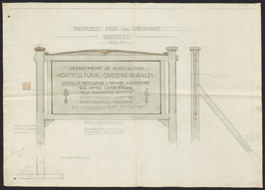
Plan, Proposed Sign for Entrance to Burnley, 1931
(1) Correspondence between Mr Zevan (Government Cool Stores), the Agricultural Superintendent, R. Crowe (Exports Superintendent) and A.W. Jessep re design for new entrance gates at Burnley Gardens, between 31.03.1931 and 09.07.1931. Invoice from signwriter (A. Clegg). (2) Pencil sketch of proposed design with annotations. (3) Coloured drawing to scale.On verso of drawing: "Gate sign & Watering plans" and "File State Public Works"a.w. jessep, burnley gardens, f. zeven, signs, victoria. department of agriculture -
 Ithacan Historical Society
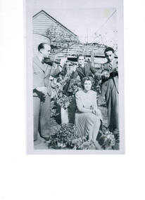
Photograph, Mildura family celebration, c1940s
Pictured l-r are Bill Florence (Vasilis Florias) playing violin, Peter (Pano) Vlass, Joyce Mason and Stathis Raftopoulos playing banjo. They are continuing the celebrations the day after Pano's and Joyce's wedding. The photo is taken in the back garden of the Golden Key Cafe in Red Cliffs which was operated by Pano's father Demetrios Vlassopoulos (Kopela). Stathi, Bill and Pano were all first cousins.The photograph reflects maintenance of family traditions and celebrations in their adopted country and the love of music. A black and white photograph of a lady and men relaxing outside a weatherboard house. The lady is seated in front of the men. A man on the LHS is playing a violin and the other on the RHS is playing the banjo. A corrugated iron water tank is behind the group. The photograph has been scanned from an original photograph. kopella, mildura -
 Lakes Entrance Historical Society
Postcard - Albert Park Lake Tyers, 1910c
Note on back to Miss Barber from Betty saying she asked Mrs Blay about accommodation etc. Also another postcard 03833.2 to a Clarence Pawsey dated 18.3.1918Sepia toned postcard showing Albert Park Guest House consisting of bedroom wing on left and detached kitchen dining wing on right, verandah across front of building with two deck chairs and bench on verandah, man and lady standing and lady sitting on bench. Extensive paths and garden in front, glimpses of other buildings at back. Two water tanks at left one round galvanized and one square, trees behind building. Lake Tyers VictoriaAlbert Park Lake Tyers Victoriawaterways, topography, guesthouses