Showing 143117 items
matching colour-photograph
-
 Greensborough Historical Society
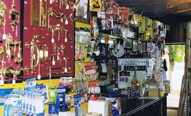
Photograph - Digital image, Frank Solomon, Briar Hill Timber Hardware Interior, 2000_
Briar Hill Timber and Hardware was situated in Sherbourne Road Briar Hill. These photographs were taken by Frank Solomon shortly before the business closed.This business and its predecessor Briar Hill Timber was a landmark in the area.Digital copy of colour photographbriar hill timber and hardware -
 Greensborough Historical Society
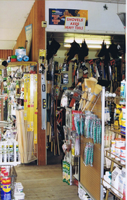
Photograph - Digital image, Frank Solomon, Briar Hill Timber Hardware Interior, 2000_
Briar Hill Timber and Hardware was situated in Sherbourne Road Briar Hill. These photographs were taken by Frank Solomon shortly before the business closed.This business and its predecessor Briar Hill Timber was a landmark in the area.Digital copy of colour photographbriar hill timber and hardware -
 Greensborough Historical Society
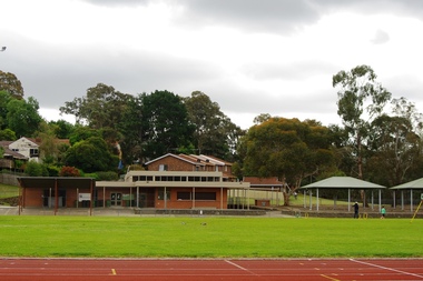
Photograph - Digital Image, Marilyn Smith, Willinda Park Buildings and facilities, 06/11/2017
Willinda Park is situated in Beatrix Street Greensborough. It has an athletics track and field and is adjacent to the Plenty River. These photographs show some of the facilities at the park.Digital copy of colour photographwillinda park, beatrix street greensborough, athletics -
 Greensborough Historical Society
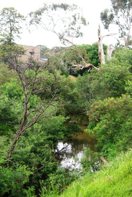
Photograph - Digital Image, Marilyn Smith, Plenty River near Willinda Park, 06/11/2017
This group of photographs shows the Plenty River adjacent to Willinda Park. Willinda Park is situated in Beatrix Street Greensborough and has an athletics track and field. Digital copy of colour photographswillinda park, beatrix street greensborough, athletics, plenty river -
 Greensborough Historical Society
Photograph - Digital Image, Marilyn Smith, Greensborough Grain Store, 183 Para Road. Display, 2014_08
This photograph shows a display (interior) of goods at the building at 183 Para Road when it was used for Greensborough Grain Store; this photo was taken in August 2014.In 2017, the Greensborough Grain Store closed its Para Road premises and now trades online.Digital copy of colour photographgreensborough grain store, para road greensborough -
 Lakes Entrance Regional Historical Society (operating as Lakes Entrance History Centre & Museum)
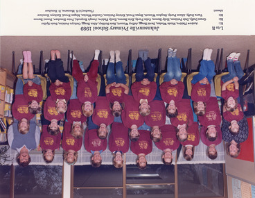
Photograph, 1989
Colour photograph of twenty five children and teachers S Mezzaros and David Henshaw from primary school Johnsonville VictoriaJohnsonville Primary School 1989. (Childrens and teachers names included as part of photograph)schools -
 Lakes Entrance Regional Historical Society (operating as Lakes Entrance History Centre & Museum)
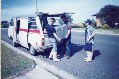
Photograph, Bennett, Vera, 1992
A second colour photo show three men loading the sounder into the back of a van for relocation (donated to LERHS)Colour photograph of the Anti Submarine Detection Investigation Committee Sounder, which Kevin and Frank Mitchelson installed in fishing boat Massbanker in 1968, to locate shoals of fish. Lakes Entrance Victoriaboats and boating, fishing industry, waterways -
 Greensborough Historical Society
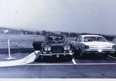
Photograph - Digital Image, Opening of Shire of Diamond Valley offices 1972: Official cars, 26/02/1972
The official opening of the Shire of Diamond Valley offices in Greensborough on 26/02/1972. This photograph shows the official car of the Governor of Victoria, (Sir Rohan Delacombe) parked in the carpark at the venue. Includes a copy of the folder cover.Photographs taken by a member of SDV staff.Photograph 1 of a folder of 21 colour photographsOn cover of folder "Opening of S.D.V. Office"shire of diamond valley, shire of diamond valley offices 1972, sir rohan delacombe -
 Ringwood and District Historical Society
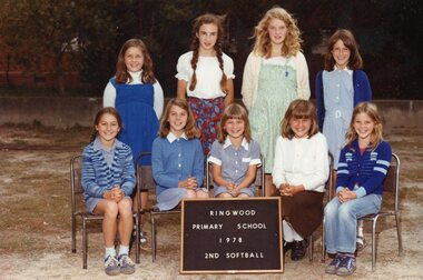
Photograph, Ringwood State School - 2nd Softball, 1978
Colour photograph - 2nd Softball, 1978."Attached to photograph" Back Row-L to R: Robyn Ison, Janet Willis, Andrea Rush, Belinda Kempton. Front Row- L to R: Julie Fawcett, Susan Green, Alison Brownrigg, Sandra Denis, Kylie Ballinger. -
 Greensborough Historical Society
Photograph - Digital image, Jasmin Burge, Grimshaw Street trees 2012, 19/06/2012
Trees along the Grimshaw Street boundary of Loyola College. Part of a collection of photographs of Loyola College, Grimshaw Street Watsonia, established 1980 on the site of the Loyola Seminary. The College purchased the original building in 2002. These photographs of the original building and grounds were taken by GHS member Jazz Burge in June 2012.Digital copy of 2 colour photographs.loyola college, grimshaw street -
 Mission to Seafarers Victoria
Photograph - Colour photograph, 2004
Photograph published in Ship to Shore 2004Colour photograph of the Mission 717 Flinders Streetmission to seafarers, 717 flinders street -
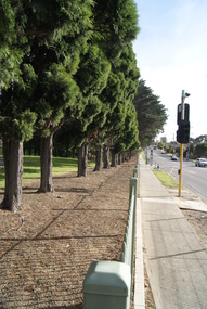
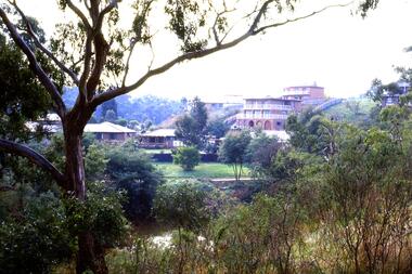
 Greensborough Historical Society
Slide - Photograph, John Ramsdale, Plenty Gorge with blackberries: Slide 87, 1990s
Photograph shows a track through trees and retaining wall. This is Plenty Gorge with blackberries in foreground.Part of the John Ramsdale collection of slides and audio visual material.Colour photograph scanned from slide.No maker's marks. No caption on slide.plenty gorge, blackberries -
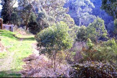
 Greensborough Historical Society
Slide - Photograph, John Ramsdale, Erosion on overgrazed property: Slide 125, 1990s
Photograph shows a fenced paddock and gum trees; erosion on overgrazed property near Whittlesea.Part of the John Ramsdale collection of slides and audio visual material.Colour photograph scanned from slide.No maker's marks. No caption on slide.whittlesea, erosion, farming -
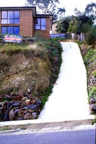 Greensborough Historical Society
Slide - Photograph, John Ramsdale, Apollo Parkways: Slide 131, 1990s
Photograph shows a house with steep drive and sold sign in the Apollo Parkways estate Greensborough.Part of the John Ramsdale collection of slides and audio visual material.Colour photograph scanned from slide.No maker's marks. No caption on slide.apollo parkways -
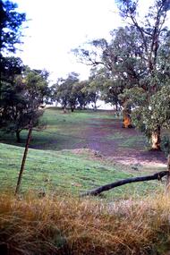
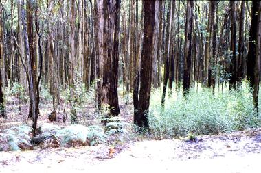 Greensborough Historical Society
Slide - Photograph, John Ramsdale, Post bushfire regrowth, Upper Plenty: Slide 31, 1990s
Photograph shows a bush scene with trees that are regenerating after a bushfire in the Upper Plenty area.Part of the John Ramsdale collection of slides and audio visual material.Colour photograph scanned from slide.No maker's marks. Caption on slide "T & Bs"bushfires, upper plenty, vegetation -
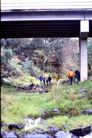 Greensborough Historical Society
Slide - Photograph, John Ramsdale, Under Greensborough Bypass: Slide 122, 1990s
Photograph shows a group of 7 people walking under an overpass - under Greensborough BypassPart of the John Ramsdale collection of slides and audio visual material.Colour photograph scanned from slide.No caption. Printed maker's mark on slide "Kodak Kodachrome Slide"greensborough bypass -
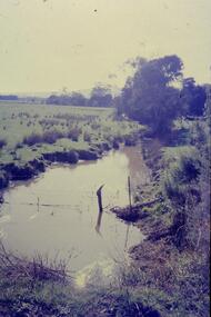
 Greensborough Historical Society
Slide - Photograph, John Ramsdale, Barbers Creek, Mernda: Slide 6, 1990s
Photograph shows washed out bush track with gully erosion at Barbers Creek, Mernda.Part of the John Ramsdale collection of slides and audio visual material.Colour photograph scanned from slide.No maker's marks. No caption on slide.erosion, barbers creek mernda -
 Greensborough Historical Society
Slide - Photograph, John Ramsdale, Encroaching suburbia: Slide 10, 1990s
Photograph shows encroaching residential looking from undeveloped to developed side of Plenty River.Part of the John Ramsdale collection of slides and audio visual material.Colour photograph scanned from slide.No maker's marks. No caption on slide.plenty river, residential development, urbanisation -
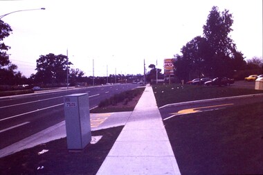 Greensborough Historical Society
Slide - Photograph, John Ramsdale, Plenty Road: Slide 13, 1990s
Photograph shows a 3 lane road with Hungry Jacks sign - Plenty Road Bundoora.Part of the John Ramsdale collection of slides and audio visual material.Colour photograph scanned from slide.No maker's marks. No caption on slide.plenty road bundoora -
 Greensborough Historical Society
Slide - Photograph, John Ramsdale, Plenty River: Slide 19, 1990s
Photograph shows low water flow on the Plenty River near South Morang or Mernda.Part of the John Ramsdale collection of slides and audio visual material.Colour photograph scanned from slide.No maker's marks. No caption on slide.south morang, mernda, plenty river -
 Greensborough Historical Society
Slide - Photograph, John Ramsdale, Vineyard: Slide 21, 1990s
Photograph shows grape vines in autumn. This vineyard is located near Rosanna Golf Course.Part of the John Ramsdale collection of slides and audio visual material.Colour photograph scanned from slide.No maker's marks. No caption on slide.vineyards, rosanna golf course -
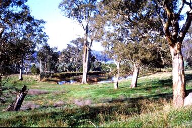 Greensborough Historical Society
Slide - Photograph, John Ramsdale, Farmland Yallambie: Slide 49, 1990s
Photograph shows a rural landscape with gum trees and dam; this is near Yallambie on the Plenty River.Part of the John Ramsdale collection of slides and audio visual material.Colour photograph scanned from slide.No maker's marks. No caption on slide.plenty river, yallambie -
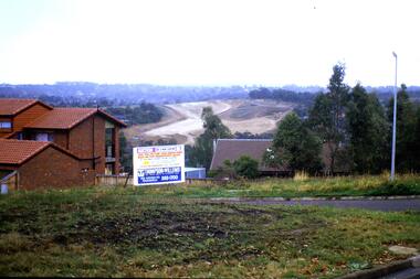 Greensborough Historical Society
Slide - Photograph, John Ramsdale, Construction of the Western Ring Road: Slide 57, 1990s
Photograph shows residential development with auction board and construction of the Western Ring Road in background.Part of the John Ramsdale collection of slides and audio visual material.Colour photograph scanned from slide.No maker's marks. No caption on slide.western ring road, metropolitan ring road, apollo parkways -
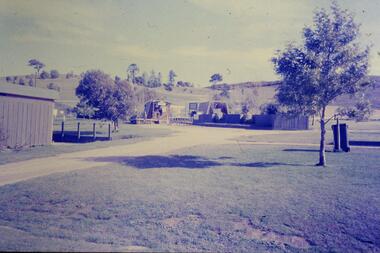 Greensborough Historical Society
Slide - Photograph, John Ramsdale, Park and kiosk, Whittlesea: Slide 63, 1990s
Photograph shows farm park and kiosk on Plenty Road Whittlesea. This is the future site of Funfields.Part of the John Ramsdale collection of slides and audio visual material.Colour photograph scanned from slide.No maker's marks. No caption on slide.funfields, plenty road whittlesea -
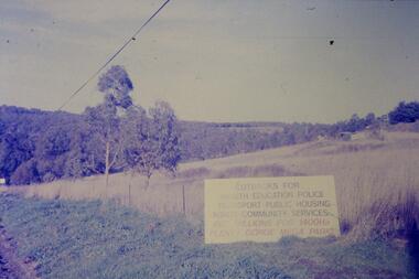 Greensborough Historical Society
Slide - Photograph, John Ramsdale, Sign - Gorge Road: Slide 76, 1990s
Photograph shows an anti- Plenty Gorge Park sign in Gorge Road South MorangPart of the John Ramsdale collection of slides and audio visual material.Colour photograph scanned from slide.No maker's marks. No caption on slide.plenty gorge, plenty gorge metropolitan park, melbourne and metropolitan board of works -
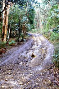
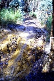 Greensborough Historical Society
Slide - Photograph, John Ramsdale, Gully erosion - motorbike track: Slide 77, 1990s
Photograph shows a washed out bush track - Gully erosion caused by motorbike trackPart of the John Ramsdale collection of slides and audio visual material.Colour photograph scanned from slide.No maker's marks. No caption on slide.erosion, gully erosion -
 Greensborough Historical Society
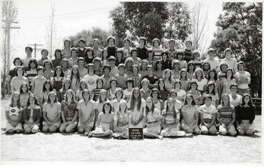
School Photograph - Digital Image, Watsonia High School, Watsonia High School WaHIGH 1976 Form 6 Combined, 1976_
A class photograph of Watsonia High School 1976 Form 6 (combined). Students are not named.Digital copy of colour school photographwatsonia high school -
 Stawell Historical Society Inc
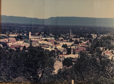
Photograph, Panorama of Stawell from Big Hill -- Coloured
Colour Laminated photograph and timber framed view of Stawell from Big Hill. c 1998 The Town Hall is at the center of photograph and the National Hotel on the left. The back of buildings can be seen at top of Main Street. Laminated and Framed photograph taken by Irene Read in c 1998 showing view of Stawell from Big Hill -- The Coloured photograph can be identified by trees in the foreground, Stawell township and mountains in background.stawell, panorama, streetscape -
 Glen Eira Historical Society
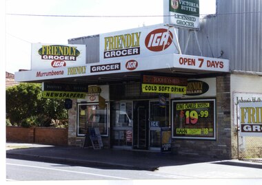
Photograph, Murrumbeena Road, 235, Murrumbeena, 2001
Originally labelled "Beauville Estate, Established 1936, Still Thriving 65 years on, 10th March 2001", the Beauville Estate Album contains colour photographs of houses in the Estate. They were taken around the time of the Beauville Estate’s 65th Heritage Celebration held on 10/03/2001 and donated to the Caulfield Historical Society shortly afterwards. Photographer unknown. No. 235 is NOT covered by the Heritage Overlay HO12.Colour photograph of a supermarket. The property features a flat roof awning, corrugated parapet, irregular multi-coloured slate tile and brick facade and extensive advertising over the front and side of the building plus on the gate to the right.Murumbeena FRIENDLY GROCER IGA / OPEN 7 DAYS / NEWSPAPERS / COLD SOFT DRINKmurrumbeena, architectural styles, 1930's, inter war style, a.v. jennings, av jennings, jennings, beauville estate, murrumbeena road, commercial establishments, shops, supermarkets, sir albert victor jennings, a v jennings construction co, beauville estate heritage area, glen eira city council, architectural features, jennings group limited, land subdivision, beauville historic area, brick shops, parapets, advertising signs, murumbeena friendly grocer iga -
 Greensborough Historical Society
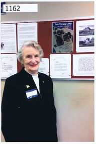
Photograph, Sue Ballantyne, Rosie Bray at NMIT archives opening, 2012_
Rosalie Bray was a guest at the opening of the NMIT Archives in 2012. In this photograph she stands in front of a display honouring her father; Tom Thrupp; who was a foundation member of staff at Preston. The display is based around the book written by Rosie 'Tom Thrupp's War' which recalls his service in World War 2 through his letters home.Colour photograph.rosalie bray, tom thrupp, nmit archives