Showing 6501 items matching "move-werke"
-
 Flagstaff Hill Maritime Museum and Village
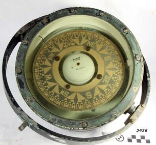
Compass, 1940's
Henry Browne and Son Ltd, of Barking, made aviation and nautical compasses, clocks and dials. The company made compasses for aircraft notably, Spitfires, Tiger moths and Concord. Henry Browne was born in Lewis, Sussex in 1842 and died in Barking in 1935. His company was a well respected English instrument maker that had been making and selling fine quality compasses, ship's clocks, inclinometers, sextants, and chandlery items for over 140 years. It started in a factory in Brightlingsea, Essex and moved to Barking in 1929. The Trade Mark brand Sestrel was used on all their equipment. Their “Dead Beat“ compass design is well dampened serving to reduce oscillations. It is reported that this design compass was fitted to many Allied ships during WW II. The company went through a boom period in the 1970s but collapsed in the 1980s due to the popularity of cheaper plastic compasses over tradition brass ones. Over more recent years, there has been a consolidation of British instrument makers and the firm of Henry Browne & Son has changed hands a number of times. At last count, it became part of Lillie & Gillie of London in 1985 when John Lilley & Gillie Ltd acquires the assets of Henry Browne & Sons (Sestrel) Ltd, a major competitor for what may be the second time. The model name of Sestral came about via the following.Take first two letters of the word Sensitive then the firs two letter of steady and the firs three letters of reliable hence the trade name of "Sestral". Item relates to the second world war used in many ships of the time merchant and military, It reminds us of a time in our social and world history when most of the world was in conflict.Henry Browne and Sons “Dead Beat“ compass design is well dampened serving to reduce oscillations and was an innervation that many makes of compass of the time din't have as a result the "Sestrel" design was fitted to many Allied ships during WW II.A liquid-filled Sestrel compass, with a brass housing and gimbal ring, wired for an internal low voltage light to illuminate the compass card. Inscriptions printed on face and impressed in metal around outer rim TRADE MARK", "Sestrel Dead-Beat", "No 1724 N", "Barking & London" HENRY BROWNE & SON", additional inscription "AFT No 1724 N". flagstaff hill, warrnambool, shipwrecked-coast, flagstaff-hill, flagstaff-hill-maritime-museum, maritime-museum, shipwreck-coast, flagstaff-hill-maritime-village, compass, marine compass, henry browne & son barking london, sestrel dead-beat marine compass, navigation instrument, sestrel dead-beat marine compass -
 Orbost & District Historical Society
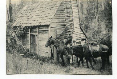
black and white photograph, early 20th century
This appears to be a photograph of Augustus Willhelm Scharlemann who was born on 16th July 1861, at Celle, Uetze, Province of Hanover, Germany. He left for Australia in August 1884. after various jobs and exploartions he travelled to South Gippsland in 1889. He got a job on the railways and then worked as a carpenter in Leongatha where he was an early builder of the township. He journeyed with a mate to the Murrungowar area and became one of the first pioneers when he selected land at Glen Arte, Upper Murrungowar in 1891. On 21st December, 1899, he became a naturalised Australian. At Murrungowar he bred a champion hunter which, when sold, won 400 prizes in two years, taking prizes at Melbourne, Sydney and Adelaide in 1911-12. He married Margaret Agnew Gray, daughter of Rev. William and Mrs. Annie Gray, at the Manse, Orbost, on 24th November 1909, and there were three children born to the couple: Elfriede Louisa Wilhelmina, born 10th October 1910, decd. 1917. Rotha Margaret, born 23rd November 1913. Donald Ross, born 22nd March 1922. After leaving Murrungowar in 1922 the family moved to Orbost where Billie did carpentry for several years. In 1929 he became curator of the Orbost Bowling Green, a position he held until about 1937. He died on 6th June 1940, and was buried on 7th June 1940, at 10 a.m. by Presbyterian Rev. J. G. Bucknall. (info. John Phillips October 2008 Newsletter)This is a pictorial record of Augustus Willhelm Scharlemann. an early settler of Murrugowar, which was a small township east of Orbost.A copy of a black / white photograph of a wooden cabin in a bush setting. On the right side there is a man on a horse holding the reins to another horse.murrungowar scharlemann-augustus-willhelm -
 Orbost & District Historical Society
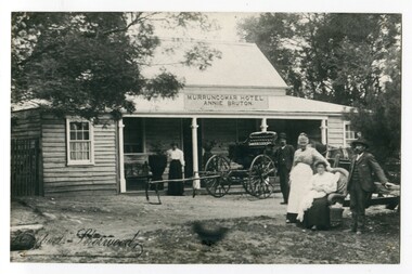
black and white photograph, early 20th century
This photograph shows Pike's buggy with Joe Pike, Mrs George Pike, Annie Bruton and Maggie Middleditch on the verandah. Annie Bruton was the wife of Jack Bruton who came to Orbost about 1891. When land was made available for selection at Murrungowar. they took up a selection and embarked in dairying, sheep-farming and pig-raising. They transformed a veritable wilderness into a productive farm by sheer hard work and liberal expenditure. By 1892 he had secured a licence for an hotel and accommodation house, store and the first post office at Murrungowar. For a time she was licensee of the Murrungowar Hotel. In December 1897 he was living at Murrungowar when he made application for a Roadside Victualler’s License for a house situated at Boulder Creek, East Gippsland, containing four rooms in course of erection, exclusive of those required for family. He was a butcher at Orbost in 1902-03 and also had a farm on the Bendoc Road. He was a member of the first Golf committee. After leasing the hotel to Jonson's he moved to Orbost and started brick-making near the Orbost water service basin on the Bendoc Road. He had the order for the bricks required for the Masonic Hall. Mr and Mrs Bruton resided at Murrungowar for 29 years. They let their property to Messrs McDONALD and sons and retired to Orbost in December 1920. Mr Bruton had not been in very good health for the last 4 or 5 years of his life, and about a fortnight prior to his death he got wet at his brick kiln, and contracted pneumonia which led to hiThis is a pictorial record of the the Murrungowar Township which was once a thriving settlement with a hotel, store, post office and school. In the 1890s pioneers were attracted to the area with the promise of a railway from Orbost. However, when the promised railway did not eventuate most of the farms were abandoned. Much of the previously cleared areas have reverted to Forest. Most of the remaining farms are now privately owned eucalypt plantations.A large black / white photograph of five people standing outside a one - storey wooden building. There is an empty buggy behind them with a horse behind it. The building has a sign above the verandah - "MURRUNGOWAR HOTEL ANNIE BRUTON".on front - "Pikes Buggy - Mrs Bruton, Mrs Geo & Mr Joe Pike" ; Herbert Sherwood photographer murrungowar-hotel bruton-annie pike-joe -
 Eltham District Historical Society Inc
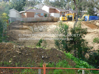
Photograph, Daryl Morrow, Redevelopment of former site of Hassall's Roadside Gallery, Main Road, Eltham, 10 July 2023
This historic site of Australia’s first open-air gallery is being redeveloped in 2023 for multi-housing fronting the Research Creek. In 1955, Ian and Joan Hassall moved to Eltham. They took a property on the corner of Zig Zag Road and Main Road, Eltham, north of the township (later known as 1215 Main Road). In July 1962, they opened their open-air gallery. Hassall’s Roadside Galley, “…cradled in the fold of hills to the north of Eltham” inspired by Ian’s own experience of exhibitions along the Embankment in London. The property included remnants of a stone quarry, paintings were hung on screens and removed at night. Various pedestals, that looked like giant mushrooms displayed sculpture, pottery, and jewellery. It had a small natural amphitheatre at the foot of a little sandstone cliff that fall away to the bed of a stream. To enter the gallery, a visitor crossed a small freestone bridge of oriental design, built by Hassall from local stone. The bridge spanned the stream flowing beneath great willow trees. Near the entrance wooden figures were displayed formed from pieces of local wood, said to speak to Ian Hassall’s sense of fun. Hassall’s Gallery was the first gallery of its kind in Australia. Ian became a full-time artist and when it first opened, he exhibited paintings he had made while touring the outback with writer and fellow Eltham resident Alan Marshall. He also exhibited other Australian artists over time including locals Lindsay Edward and Peter Glass.daryl morrow collection, eltham heights luxury living, hassalls roadside gallery, housing development, real estate development, research creek, 2023-07-10 -
 Eltham District Historical Society Inc
Photograph, Daryl Morrow, Redevelopment of former site of Hassall's Roadside Gallery, Main Road, Eltham, 13 July 2023
This historic site of Australia’s first open-air gallery is being redeveloped in 2023 for multi-housing fronting the Research Creek. In 1955, Ian and Joan Hassall moved to Eltham. They took a property on the corner of Zig Zag Road and Main Road, Eltham, north of the township (later known as 1215 Main Road). In July 1962, they opened their open-air gallery. Hassall’s Roadside Galley, “…cradled in the fold of hills to the north of Eltham” inspired by Ian’s own experience of exhibitions along the Embankment in London. The property included remnants of a stone quarry, paintings were hung on screens and removed at night. Various pedestals, that looked like giant mushrooms displayed sculpture, pottery, and jewellery. It had a small natural amphitheatre at the foot of a little sandstone cliff that fall away to the bed of a stream. To enter the gallery, a visitor crossed a small freestone bridge of oriental design, built by Hassall from local stone. The bridge spanned the stream flowing beneath great willow trees. Near the entrance wooden figures were displayed formed from pieces of local wood, said to speak to Ian Hassall’s sense of fun. Hassall’s Gallery was the first gallery of its kind in Australia. Ian became a full-time artist and when it first opened, he exhibited paintings he had made while touring the outback with writer and fellow Eltham resident Alan Marshall. He also exhibited other Australian artists over time including locals Lindsay Edward and Peter Glass.daryl morrow collection, eltham heights luxury living, hassalls roadside gallery, housing development, real estate development, research creek, 2023-07-13 -
 Eltham District Historical Society Inc
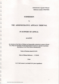
Document - Folder, Ron F. McCormack, Appeal against Eltham Shire Permit granted for a propsed Youth Enterntainment Centre, 41-43 Were Street, Montmorency, 1993-1994
In 1993 Eltham Shire Council issued a permit to Michael Muzur, Terry Lant and Andrew McMillan to redevelop the former Montmorency Theatre/Bingo Hall at 41-43 Were Street as an alcohol-free youth entertainment centre. Ron McCormack, retired former JP on behalf of 41 Joint Appellants consisting of local residents and traders successfully lobbied the community and won an Appeal to have the permit cancelled as unsuitable development. The Administrative Appeal Tribunal found that the proposed development came withing the Eltham Planning Scheme definition of an 'amusement parlour' and that the playing of pool an amusement machines would be the focus of the centre and unlikely to attract older age groups. The tribunal was not satisfied the applicants had sufficient knowledge or where with all required for the successful running of this type of operation. With respect to the objectors, the Tribunal did not accept that a responsibly managed and attractive amusement parlour could not coexist near the adjoining residential area and without detriment to the commercial centre. At a Council meeting on June 7, 1994 councillors requested a report outlining criteria to be used to assess planning applications for youth entertainment venues given the Tribunal's view that a poorly managed facility in a small neighbourhood shopping centre, particularly in such close proximity to a residential area would not only have the potential to increase perceived youth problems, but could jeopardise the prospects of future proposals. Ron McCormack moved to Montmorency from Coburg in the early 1980s and from then sat on the bench at Eltham Courthouse when Police requested assistance out of hours, until the eventuial closure of the Courthouse. montmorency theatre, montmorency bingo hall, 41-43 were street, youth entertainment centre, eltham shire council, planning permit, administrative appeals tribunal, ron f mccormack -
 Eltham District Historical Society Inc
Document - Property Binder, 1524 Main Road, Research
Handwritten notes, undated, on A & G Bills horse trough Main Road Research. Handwritten notes, undated, "Annie and George Bills" listing locations of other Bills horse troughs. Typed notes by Dianna Basset-Smith, July 2003, her memories of the Bills trough at Research. Letter, RSPCE to Andrew Lemon, 17 December 1993, lists other horse troughs known to the RSPCA, use of money from Bills estate managed by John Crook. Newspaper article: Legacy is set in concrete, The Weekly Times, 25 June 2003, history of Bills horse troughs from 1930s, biography of George Bills and Annis Swarm [correctly Swann], quoting Barbie Roach, Gorge Bills' great-grandneice, notes locations of other Bills troughs. Newspaper article: No drought in water troughs, Weekly Times, 9 July 2003, Response to 25 June 2003 article, readers reporting Bills troughs in their area, photograph of trough at Korong Vale. Newspaper article: The horse lover, (photocopy, no publication details), Decaying Bills horse tough in Geelong council yard proposed to be moved to RSPCA, history of George Bills, Annis Bills (nee Swann), legacy, great-grandneice Judith Crook writing Bills history. Email exchange, Eltham District Historical Society and Geraldine Sanderson 2015: enquiry re Bills trough at Research for planned history of Bills trough, and provision of EDHS-held information.Annis Elizabeth Swannmain road, research (vic.), horse troughs, annis and george bills, bills trough, audrey bills, annis bills, george bills, barbie roach, royal society for the prevention of cruelty to animals, judith crook, audrey morton, kathleen wood, acclimatisation society, john lugg, ian stacey, harry bills, annis swann, james boreas crook, william buesst, myer emporium, richard bills, buesst and bills brothers, daisy bills -
 Eltham District Historical Society Inc
Document - Folder, Morrison: Sir William Irvine, Beatrice Wanliss Morrison
William Hill Irvine came from Northern Ireland around 1879 and lived in Heidelberg. He became a barrister and Member for Flinders Electorate, serving at various times as Attorney-General, Chief Justice, Premier and Lieutenant-Governor of Victoria. His daughter Beatrice married James Morrison and lived in Eltham. Irvine's other children were William and Agnes. William became Crown Prosecutor. Agnes married Ian Hayward and moved to Adelaide. Beatrice worked with the War Service Committee, raising money for the Red Cross and became chairman of the War Memorial Committee which built the Baby Health Centre, the Children's Library and the Pre-School Centre in Eltham. The family were interlinked with other local people. Contents Document by Beatrice W Morrison, 8 May no year given but pre 1989: life of Sir William Hill Irvine, his daughter Beatrice Wanliss Morrison and her husband James Morrison, and memories of Eltham and residents. Document summarising life of Beatrice Wanliss Morrison, undated but post 1989. Letter from Beatrice Williams to Eltham Shire, 29 September 1985: endorsing the idea of a nature corridor through Eltham Shire to the Great Dividing Range, noting she nursed the Morrison family before WWII. Letter from Health Shire to Beatrice Williams, 9 October 1985: acknowledging letter. Newspaper death notice, The Age, 19 March 2008: William Irvine Askin Morrison. Newspaper clippings, A4 photocopies, etcwilliam hill irvine, james morrison, agnes hayward nee morrison, war service committee eltham, red cross, baby health centre eltham, children's library eltham, pre-school centre eltham, somerville morrison, archie morrison, virginia morison, michael irvine, ian hayward, bill hayward, killeavy eltham, mccoll family eltham, logan family eltham, dry creek eltham, jack mccoll, burke and wills, orford family, andersons family, mount pleasant road eltham, reynolds road eltham, eddy anderson, reynolds family, sweeney family, sweeney's lane eltham, burston family, carrucan family, beatrice wanliss morrison nee irvine, beatrice williams, thomas watson haymes, william irvine askin morrison -
 Eltham District Historical Society Inc
Photograph, Frank Stokes with his mother Florence (nee West) and children, Dorothy (left), David (centre) and Beryl (right), Stokes Orchard, Nyora Road, Eltham, c.1950, 1950c
Frank's mother Florence was visiting from England at the time. Frank Stokes first traveled to the district by train in 1944 to find land with the intention to establish an orchard. By chance he met Arthur Bird of Bird Orchard (bounded by Pitt Street, Eucalyptus Road and Wattle Grove) and they got talking over their common interest. Arthur put Frank up for the night and pointed out the land, part of Crown Allotment 15, Section 5, Parish of Nillumbik (CA15) somewhat diagonally opposite Bird Orchard. Frank bought the land and for the next two years would travel by train from Melbourne to Eltham every weekend establishing Stokes Orchard and building a home for his family, which they eventually moved into in 1946. In the mid 1970s the Shire of Eltham divided the orchard up into numerous rate-able parcel lots, which became affordable for Frank. As a consequence Stokes Orchard was turned into a housing development by Macquarie Builders and marketed as the Stokes Orchard Estate in two stages; Stage 1 encompassing Scarlet Ash Court, Ironbark Close and Peppermint Grove bounded by Nyora and Eucalyptus roads c.1976 and Stage 2 encompassing Stokes Place, Orchard Way, The Crest and The Lookout bound by Nyora and Diosma roads c.1979. The development of Orchard Way, The Crest and The Lookout did not proceed as planned due to the lack of the sewer along Diosma Road and so many of the proposed lots were incorporated into five-acre parcels instead.Representative of the orchard growing areas of ElthamDigital file only - Digitised by EDHS from a scrapbook (containing commercially printed photos of digital scans) on loan from Beryl Bradbury (nee Stokes), daughter of Frank Stokes.1950, beryl bradbury (nee stokes), beryl bradbury (nee stokes) collection, david stokes, dorothy stokes, eltham, flatbed truck, florence stokes (nee west), frank stokes, nyora road, stokes orchard -
 Eltham District Historical Society Inc
Photograph, The Stokes family home blanketed with snow, corner Nyora and Eucalyptus roads, Eltham, winter 1951, 1951
Taken from outside the family home on the southest corner of the intersection of Nyora Road and Pitt Street with Eucalyptus Road. Frank Stokes first traveled to the district by train in 1944 to find land with the intention to establish an orchard. By chance he met Arthur Bird of Bird Orchard (bounded by Pitt Street, Eucalyptus Road and Wattle Grove) and they got talking over their common interest. Arthur put Frank up for the night and pointed out the land, part of Crown Allotment 15, Section 5, Parish of Nillumbik (CA15) somewhat diagonally opposite Bird Orchard. Frank bought the land and for the next two years would travel by train from Melbourne to Eltham every weekend establishing Stokes Orchard and building a home for his family, which they eventually moved into in 1946. In the mid 1970s the Shire of Eltham divided the orchard up into numerous rate-able parcel lots, which became affordable for Frank. As a consequence Stokes Orchard was turned into a housing development by Macquarie Builders and marketed as the Stokes Orchard Estate in two stages; Stage 1 encompassing Scarlet Ash Court, Ironbark Close and Peppermint Grove bounded by Nyora and Eucalyptus roads c.1976 and Stage 2 encompassing Stokes Place, Orchard Way, The Crest and The Lookout bound by Nyora and Diosma roads c.1979. The development of Orchard Way, The Crest and The Lookout did not proceed as planned due to the lack of the sewer along Diosma Road and so many of the proposed lots were incorporated into five-acre parcels instead.Representative of the orchard growing areas of Eltham. One of the rare times it has snowed in ElthamDigital file only - Digitised by EDHS from a scrapbook (containing commercially printed photos of digital scans) on loan from Beryl Bradbury (nee Stokes), daughter of Frank Stokes.1951, beryl bradbury (nee stokes) collection, eltham, eucalyptus road, nyora road, snow, stokes family home -
 Eltham District Historical Society Inc
Photograph, The first houses in construction on the new Stokes Orchard Estate, July 1976, July 1976
Viewed from near the Stokes family home at 1 Nyora Road looking northeast across Ironbark Close to Scarlet Ash Court with Peppermint Grove in the distance. Frank Stokes first traveled to the district by train in 1944 to find land with the intention to establish an orchard. By chance he met Arthur Bird of Bird Orchard (bounded by Pitt Street, Eucalyptus Road and Wattle Grove) and they got talking over their common interest. Arthur put Frank up for the night and pointed out the land, part of Crown Allotment 15, Section 5, Parish of Nillumbik (CA15) somewhat diagonally opposite Bird Orchard. Frank bought the land and for the next two years would travel by train from Melbourne to Eltham every weekend establishing Stokes Orchard and building a home for his family, which they eventually moved into in 1946. In the mid 1970s the Shire of Eltham divided the orchard up into numerous rate-able parcel lots, which became affordable for Frank. As a consequence Stokes Orchard was turned into a housing development by Macquarie Builders and marketed as the Stokes Orchard Estate in two stages; Stage 1 encompassing Scarlet Ash Court, Ironbark Close and Peppermint Grove bounded by Nyora and Eucalyptus roads c.1976 and Stage 2 encompassing Stokes Place, Orchard Way, The Crest and The Lookout bound by Nyora and Diosma roads c.1979. The development of Orchard Way, The Crest and The Lookout did not proceed as planned due to the lack of the sewer along Diosma Road and so many of the proposed lots were incorporated into five-acre parcels instead.Housing development in Eltham as an extension to the Woodridge EstateDigital file only - Digitised by EDHS from a scrapbook (containing commercially printed photos of digital scans) on loan from Beryl Bradbury (nee Stokes), daughter of Frank Stokes.1976-07, beryl bradbury (nee stokes) collection, building construction, ironbark close, nyora road, peppermint grove, scarlet ash court, stokes orchard estate, houses -
 Bendigo Military Museum
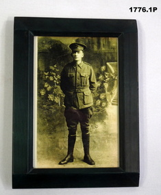
Photograph - PHOTOGRAPHS WW1, FRAMED, All three, 19414 - 18
John James Hindley No 2747 enlisted in the AIF on 2.7.1915 age 26 years 9 months. Embarked for Egypt 15.9.1915 then joined unit on Gallipoli 13.11.1915, hospital 14.12.1915 with Influenza, rejoin unit 22.12.1915, transfer to 4th machine Gun Coy 6.4.1916, embark for France 1.6.1916, reported WIA and missing reincourt 11.4.1917, reported POW, died while POW at Dulmen Germany 6.5.1917. Francis Grant Hindley No 790 enlisted in the AIF on 18.8.1914 age 19 years. Embark for Egypt 19.10.1914, embark for Gallipoli 5.4.1915, WIA 6.7.1915 with shock/concussion and then gets Influenza, rejoin unit 9.1.1916, transfer to 59th Batt 24.2.1916, transfer to 57th Batt 20.3.1916, embark for France 17.6.1916, transfer to 58th Batt 23.7.1916, promoted Sgt 1.4.1917, hospital with Scabies 21.7.1917, rejoin unit 25.7.1917, reverts to ranks 5.8.1917, promoted L/Cpl 15.9.1917, hospital 15.10.1917, with Haemorroids, rejoin unit 22.10 1917, embark for Australia 25.3.1918, discharged medically unfit 21.8.1918. Harold Hindley No 2570 enlisted in the AIF in 8th reinforcements 5th Batt on 8.7.1915 age 30 years 8 months. Embark for Egypt 15.9.1915, on Gallipoli 7.12.1915, embark for France 25.3.1916, hospital 11.7.1916, with I.C.F Heel, rejoin unit 19.7.1916, WIA 16.8.1916 GSW right thigh severe, shell contusions back and shoulder, from there he moves through various convalescent depots and units until embark for Australia for discharge on 19.10.1918, discharged from the AIF 11.2.1919.B&W portraits of the Hindley brothers in uniform. All items have dark green wooden frames. .1) John Hindley, full length standing, hands behind back with flowers and stairs in background. .2) Francis Hindley, full length standing with dog. .3) Harold Hindley, head and shoulders, photo is oval shaped.photography-photographs, military history -
 Flagstaff Hill Maritime Museum and Village
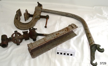
Equipment - Rocket Launcher, Government of Victoria, ca 1910s
This rocket launcher has fittings to mount it onto a lifeboat or similar vessel. Once mounted, a it would be fitted with a line-throwing rocket that would be launched from the vessel and aimed over the shipwreck. The line would be fixed to the ship in distress. A heavier line would then be sent out to the wrecked vessel and survivors would be hauled to safety. Its design suggests that it dates to the First World War ear of the 1910s. The coastline of South West Victoria is the site of over 600 shipwrecks and many lost lives; even in Warrnambool’s Lady Bay there were around 16 known shipwrecks between 1850 and 1905, with eight lives lost. Victoria’s Government responded to the need for lifesaving equipment and, in 1858, the provision of rocket and mortar apparatus was approved for the lifeboat stations. In 1859 the first Government-built lifeboat arrived at Warrnambool Harbour and a shed was soon built for it on the Tramway Jetty, followed by a rocket house in 1864 to safely store the rocket rescue equipment. In 1878 the buildings were moved to the Breakwater (constructed from 1874-1890), and in 1910 the new Lifeboat Warrnambool arrived with its ‘self-righting’ design. For almost a hundred years the lifesaving and rescue crews, mostly local volunteers, trained regularly to rehearse and maintain their rescue skills. They were summoned when needed by alarms, gunshots, ringing bells and foghorns. In July 1873 a brass bell was erected at Flagstaff Hill specifically to call the rescue crew upon news of a shipwreck. Some crew members became local heroes but all served an important role. Rocket apparatus was used as recently as the 1950s. This item is significant for its connection with maritime history and marine technology. Lifesaving has been an important part of the services performed coastal Victoria, including Warrnambool, in its very early days, supported by State and Local Government, and based on the methods and experience of Great Britain. Hundreds of shipwrecks along the coast are evidence of the rough weather and rugged coastline. Ordinary citizens, the Harbour employees, and the volunteer boat and rescue crew, saved lives in adverse circumstances. Some were recognised as heroes, others went unrecognised.Rocket launcher, lifesaving equipment, attaches to rail on vessel. Schermuly's Patent, Grey metal, L shaped pipe with large clamp on one end and small, hooked U shaped fitting on the other. Connects to half-cylinder sleeve with gimbal fitting, ball joint and adjusting fittings; painted grey and red. "SCHERMULY'S PATENT" cast into clamp.Cast into metal "SCHERMULY'S PATENT" flagstaff hill, flagstaff hill maritime museum and village, warrnambool, maritime museum, maritime village, great ocean road, shipwreck coast, rocket launcher, rocket apparatus, rocket firing equipment, lifesaving equipment, wwi, world war i, 1210s, schermuly’s patent, schermuly launcher, sea rescue, lifesaving, shipwreck, life-saving, rescue crew, rocket rescue, rocket crew, line rescue, maritime activities, marine technology, volunteer crew, boat to ship rescue, william schermuly, -
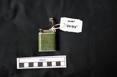 City of Moorabbin Historical Society (Operating the Box Cottage Museum)
Manufactured objects, Cigarette lighter metal, 20thC
A cigarette lighter is a portable device used to generate a flame. It consists of a metal or plastic container filled with a flammable fluid or pressurized liquid gas, a means of ignition, and some provision for extinguishing the flame. A spark is created by striking metal against a flint, or by pressing a button that compresses a piezoelectric crystal (piezo ignition), generating an electric arc. In naphtha lighters, the liquid is sufficiently volatile, and flammable vapour is present as soon as the top of the lighter is opened. Butane lighters combine the striking action with the opening of the valve to release gas. The spark ignites the flammable gas causing a flame to come out of the lighter which continues until the top is closed (naphtha type), The Beney Company was founded by Robert Ernest Beney of London, England. R. E. Beney invented and marketed the first Beney mechanical lighter in 1919. Beney also designed and manufactured numerous luxury lighters and striker boxes for Alfred Dunhill of London as well as Hermes of Paris. In 1938, Beckenham based Beney Lighters was acquired, adding utility lighters and precision tools to the company's (Winn & Coates) ever growing list of products. The biggest selling line manufactured by Beney was the Economic Gas Lighter which hung on the side of housewife's gas cookers and was also used for lighting Bunsen burners in laboratories. In 1939-1940 the company moved its administration to the Beney Lighter premises in Beckenham after the Head Office at Trinity Square along with many company records were destroyed in a 'doodlebug' flying bomb attack. Beney Ltd. continued producing lighters at least through the late 1954. A green metal cigarette lighter that used fuel and a striking action arm to produce a flame .base: BENEY / COMPANION / PATENT 568897 / BRITISH MADEtobacco, cigarettes, cigarette lighters, fuels, moorabbin, cheltenham, bentleigh, early settlers, beney pty ltd, beckenham england -
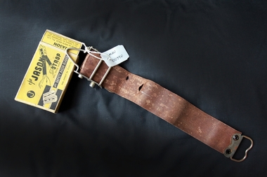 City of Moorabbin Historical Society (Operating the Box Cottage Museum)
Personal Effects, leather strop 'Jason', c1940
A razor strop (or razor strap) is a flexible strip of leather or canvas used to straighten and polish the blade of a straight razor, a knife, or a woodworking tool like a chisel. Unlike honing or sharpening a blade, in which a whetstone removes metal bent out of alignment from the blade's edge, stropping the blade re-aligns the indentations without removing any material. The strop may be a hanging strop or a hand-held paddle. Various abrasive compounds may be applied to the strop to aid in polishing the blade while stropping to obtain a mirror-like finish. The properties of the compound applied will alter the polishing result. Jeweller's rouge is a very fine abrasive compound. The green Chromium(III) oxide compound is most often used as an abrasive compound. Sprays containing diamond particles are another option. Stropping is primarily done with straight razors, used for shaving, as these are the thinnest blades in everyday use, and require stropping at each use, due to the thinness of the blade Two points are key to stropping: Draw the blade spine-first along the strop. By contrast, honing is done edge-first. When you turn the blade at the end of a stroke, turn it over the spine, so the edge moves away from the strop and faces you, and the spine rests on the strop. This preserves the edge – if the blade is turned over with the edge against the strop, this will roll the blade edge, defeating the purpose of stropping As the use of safety razors increased in popularity this 'Jason' strop prolonged the life of each razor blade thus making them economical.A leather 'Jason' strop, for sharpening safety shaving razor blades, with box. Top of Box: J / The JASON / STROP/ Reg. Trade Mark / for SAFETY RAZOR BLADES / Reg. Patent No. 25435/35 ; Back : How to operate the JASON STROP ( instructions) Side: JASON / Razor Strop Dressing / A keen smooth blade will always be assured by the / occasional use of JASON RAZOR STROP DRESSING/ Side: FIFTY SHAVES WITH ONE BLADE ! / by using - JASON and JASON / Razor Blade Strop Razor Blade Dressing. End: JASON / Made by MEIK BROS. Pty. Ltd. / 15-17 Bedford St., Collingwood, and / 287 Flinders Lane, Melbourne, Vic. End: JASON / SAFETY RAZOR BLADE STROP.safety razors, the jason strop, shaving equipment, personal effects, strops, meik bros pty ltd, gillette, collingwood melbourne -
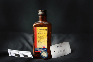 City of Moorabbin Historical Society (Operating the Box Cottage Museum)
Manufactured Glass, brown bottle 'Campholine', c1950
Sigma was founded by two Melbourne pharmacists in 1912, it has grown to become one of the key players in Australia’s pharmacy industry .Edwin Thomas Church (1864 – 1947) and Ernest Holloway Leete a prominent chemist and a member of the College of Pharmacy who had established his own pharmacy in 1897. The entrepreneurial Leete had been part of a move in 1904 among a group of commercially-minded chemists to put up proprietary preparations. 1913 - 1927 Initially, the fortunes of the Sigma enterprise relied on E. H. Leete ‘working from home’, and even as late as 1915 company address was in Claremont Avenue Malvern. Following the establishment of the business in 1912, the Sigma Company Limited was located at Flinders Lane, Melbourne. Sigma – Tromax, 1928 E.H. Leete after sixteen years, said he would not stand again as a director of the company because interests were also turning elsewhere. He was assisting another company as its agent in the motor trade. 1938 to1953 was characterised by steady growth for Sigma, accelerated by manufacturing opportunities during World War Two. Between 1975 and 1996 the company was transformed as it entered a period of both consolidation and rapid growth. The appointment, in 1996, of new Managing Director, George Savvides, marked a break from the past. Today Sigma is a leading full line wholesale and distribution business to pharmacy. Sigma is also the owner of some of Australia’s best known pharmacy brands in Amcal, Guardian and Amcal MaxA triangular shaped, brown glass, bottle with a metal screw top containing ‘Campholine’Front label : Campholine / Camphorated / Mineral Oil / CAUTION ! / Use strictly in accordance / with the directions / Adults : Rub briskly on parts affected . Infants ; Use gentle massage . / 20z. / TROMAX / SIGMA CO. Ltd. / MELBOURNE / Label Sticker : ROBERTSON OF ELSTERNWICK 1/ 8 pharmacy, medicines, campholine, glassware, bottles, moorabbin, bentleigh, cheltenham, melbourne, tromax-sigma co ltd, leete ernest, church edwin, sigma company pty ltd -
 Eltham District Historical Society Inc
Negative - Photograph, Burgoyne family outside J.N. Burgoyne's Store, Main Road, Eltham, Vic, 1940
The store built in 1925 was located on Main Road just south of Bridge Street (present day No. 820 Main Road). An extension was added to the right in 1939. The store was built in late 1925 at the same time as Mr C. Nicholls’s new store was constructed. Both were considered modern shops, and an improvement on most, business establishments of the time. Mr. Nicholls’s store included alongside it a modern, weatherboard villa residence. Mr. Burgoyne’s store incorporated the post and telegraph office, which was operated by John Neville Burgoyne’s half-aunt, Miss Anne Hunniford until her death in 1928 at which time J.N. Burgoyne became postmaster. The unsealed footpath in front is reasonably extensive as not visible is a concrete kerb and channel which was laid from the Post Office to John Street during Nov-Dec 1926. Footpath construction in front of Burgoyne’s store commenced August 1942. The extension to the right of the store was erected in 1939 for a new telephone exchange adjacent to the store and post office. A continuous telephone service operated by Mr Burgoyne and his family commenced operation 18 November 1939. Approximately 70 extensions were routed through the new exchange, 40 of which were transferred from the Greensborough Exchange. Entry to the exchange was via a separate door on Main Road or via the shop. The public telephone was initially mounted on the wall but later moved to the street. Cross Ref: 0701 of the store c.1934This photo forms part of a collection of photographs gathered by the Shire of Eltham for their centenary project book,"Pioneers and Painters: 100 years of the Shire of Eltham" by Alan Marshall (1971). The collection of over 500 images is held in partnership between Eltham District Historical Society and Yarra Plenty Regional Library (Eltham Library) and is now formally known as the 'The Shire of Eltham Pioneers Photograph Collection.' It is significant in being the first community sourced collection representing the places and people of the Shire's first one hundred years.Digital image 4 x 5 inch B&W Negshire of eltham pioneers photograph collection, burgoyne's shop, eltham, main road, post office, shops -
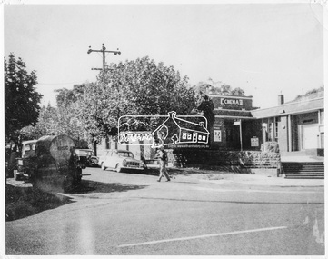 Eltham District Historical Society Inc
Negative - Photograph, Ian McDonald, Corner of Main Road and Arthur Street, Eltham, 4 Jan. 1968
The intersection of Arthur Street and Main Road Eltham, January 4, 1968. The Eltham Shire Council hall and offices on the right hand side. The Hall was also a cinema and operated as the Plaza Theatre from 1943 to about 1968. A truck with a water tank is on the left of the street, possibly cleaning the street. Note Cinema sign on hall. Copied from an original document produced by Ian McDonald (Eltham Shire Council) 1970. During the period 1969-1971 photos were being collected for a proposed publication on the history of the Shire of Eltham as part of its centenary celebrations in 1971 (managed by the Shire of Eltham Historical Society and Alan Marshall). The publication was Pioneers & Painters (1971), edited by Alan Marshall. The document titled "Shows area sold to Woolworths" consisted of a panorama of three B&W photo prints creating a panorama of the frontage along Main Road (SEPP_0744) and a single B&W photo print of the Shire of Eltham offices and Hall on the corner of Arthur Street and Main Road (SEPP_0737) along with typed and hand written notes by Ian McDonald. The panorama (SEPP_0744) was captioned in typewritten text "Old Shire Office and Hall, etc - Frontage of 285 feet along Main Road" and in pencil the date "4-1-68" The single image of the shire offices (SEPP_0737) was captioned in typewritten text "Main Road and Arthur Street Corner" In addition, the following handwritten notes in pencil: " I took these photos from the new fire station - the building in the middle is the old fire station - Moved to Research for the Scouts 1970" and signed "IMcD"This photo forms part of a collection of photographs gathered by the Shire of Eltham for their centenary project book,"Pioneers and Painters: 100 years of the Shire of Eltham" by Alan Marshall (1971). The collection of over 500 images is held in partnership between Eltham District Historical Society and Yarra Plenty Regional Library (Eltham Library) and is now formally known as 'The Shire of Eltham Pioneers Photograph Collection.' It is significant in being the first community sourced collection representing the places and people of the Shire's first one hundred years.Digital image 4 x 5 inch B&W Negsepp, shire of eltham pioneers photograph collection, eltham, arthur street, cinema, eltham hall, main road, shire hall, motion picture theartre, plaza theatre -
 Eltham District Historical Society Inc
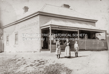
Photograph, Baker and Grocer shop, cnr. Main Road and York Street, Eltham, c.1902
Baker and Grocer store, cnr. Main Road and York Street, Eltham, early 1900s. Sign on side of building "Baker, Grocer & Summer Drinks" This image appears to be of the baker/grocery store after it was purchased in 1902 by Mrs Sarah Burgoyne and her husband, John James Thomas Burgoyne. It is possible that Mrs Sarah Burgoyne is the lady in front of the store with her eldest daughter, Charlotte and youngest son, James. Another daughter (Frances) and the family dog are watching from the doorway. In 1902 Mrs Sarah Burgoyne purchased from Wilfred Henry Johnston, the property on the southern corner of Main Road and York Street, Eltham, which consisted of a store and bakery establishment occupied by Mr. Luther Haley whose lease had expired around the same time. Mr. Haley had not been prepared to leave as he was unable to secure at Eltham a suitable house in which to carry on his business. Wilfred Johnston applied for an eviction of Hayley, which was heard at Eltham Courthouse in August 1902. Hayley advised he was building a place near the railway station which he expected to be done in about three weeks’ time. The court gave him the three weeks to vacate. Hayley’s new premises near the station became the present shopping district’s first shop and he ran it successfully till 1917 when the family moved to Clifton Hill, and he became a publisher. Their eldest child Leslie drowned in the Diamond Creek in early 1904, aged 12.Sepia photograph mounted on cardeltham, eltham bakery, grocer, john james thomas burgoyne, main road, sarah jane burgoyne (nee benson), summer drinks, york street -
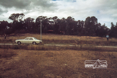 Eltham District Historical Society Inc
Photograph, Land size highlighted by Tiny and Carla Vermey standing at each corner, 1979
14 Stokes Place (Lot 83) was the home of Peter and Carla Vermey. The land was purchased in May 1979 and construction commenced September 1979. The home was built by Peter and Carla Vermey after the developer, Macquarie Builders went bankrupt. Sold October 2017 by Morrison and Kleeman Real Estate. Stokes Place was part of the Stokes Orchard Estate which was developed from the break-up of the the orchard owned by Frank Stokes who lived on the northeast corner of Nyora Road and Eucalyptus Road. His daughter Beryl advised that the Shire had levied a rate assessment on individual parcels of land within the orchard which became unaffordable resulting in its sub-division and sell off. The Stokes Orchard Estate was developed by Macquarie Builders in two stages starting with stage 1 in 1976. Stokes Place was part of Stage 2 in 1979. The Estate was bounded between Nyora Road, Eucalyptus Road, Diosma Road and Stokes Place. The original orchard only just reached the left most portions of Stokes Place and did not go fully up to Diosma, rather to just beyond the extant of Stokes Place. Stokes Place was known within the family as "The Oats" as that is where they grew oats. Frank Stokes moved to Eltham c.1945 after visiting Harold Bird to view his orchard, located diagonally opposite Stokes Orchard from the intersection of Eucalyptus Road, Pitt Street and Nyora Road. It was on Harold Bird's recommendation that Frank purchased the land.The Stokes Orchard Estate collection is typical of housing developments of the late 1970s and 1980s. It was one of the earliest estates in Eltham following the nearby Woodridge Estate development.Digital fileScanned by EDHS from 49 x 35mm colour transparencies provided on loanstokes place, eltham, stokes orchard, stokes orchard estate, streets, houses, peter and carla vermey -
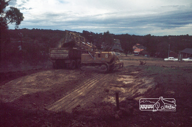
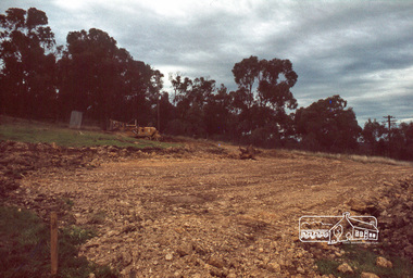 Eltham District Historical Society Inc
Photograph, Excavation of dwelling, 1979
14 Stokes Place (Lot 83) was the home of Peter and Carla Vermey. The land was purchased in May 1979 and construction commenced September 1979. The home was built by Peter and Carla Vermey after the developer, Macquarie Builders went bankrupt. Sold October 2017 by Morrison and Kleeman Real Estate. Stokes Place was part of the Stokes Orchard Estate which was developed from the break-up of the the orchard owned by Frank Stokes who lived on the northeast corner of Nyora Road and Eucalyptus Road. His daughter Beryl advised that the Shire had levied a rate assessment on individual parcels of land within the orchard which became unaffordable resulting in its sub-division and sell off. The Stokes Orchard Estate was developed by Macquarie Builders in two stages starting with stage 1 in 1976. Stokes Place was part of Stage 2 in 1979. The Estate was bounded between Nyora Road, Eucalyptus Road, Diosma Road and Stokes Place. The original orchard only just reached the left most portions of Stokes Place and did not go fully up to Diosma, rather to just beyond the extant of Stokes Place. Stokes Place was known within the family as "The Oats" as that is where they grew oats. Frank Stokes moved to Eltham c.1945 after visiting Harold Bird to view his orchard, located diagonally opposite Stokes Orchard from the intersection of Eucalyptus Road, Pitt Street and Nyora Road. It was on Harold Bird's recommendation that Frank purchased the land.The Stokes Orchard Estate collection is typical of housing developments of the late 1970s and 1980s. It was one of the earliest estates in Eltham following the nearby Woodridge Estate development.Digital fileScanned by EDHS from 49 x 35mm colour transparencies provided on loanstokes place, eltham, stokes orchard, stokes orchard estate, streets, houses, peter and carla vermey -
 Eltham District Historical Society Inc
Photograph, Excavation of garage, 1979
14 Stokes Place (Lot 83) was the home of Peter and Carla Vermey. The land was purchased in May 1979 and construction commenced September 1979. The home was built by Peter and Carla Vermey after the developer, Macquarie Builders went bankrupt. Sold October 2017 by Morrison and Kleeman Real Estate. Stokes Place was part of the Stokes Orchard Estate which was developed from the break-up of the the orchard owned by Frank Stokes who lived on the northeast corner of Nyora Road and Eucalyptus Road. His daughter Beryl advised that the Shire had levied a rate assessment on individual parcels of land within the orchard which became unaffordable resulting in its sub-division and sell off. The Stokes Orchard Estate was developed by Macquarie Builders in two stages starting with stage 1 in 1976. Stokes Place was part of Stage 2 in 1979. The Estate was bounded between Nyora Road, Eucalyptus Road, Diosma Road and Stokes Place. The original orchard only just reached the left most portions of Stokes Place and did not go fully up to Diosma, rather to just beyond the extant of Stokes Place. Stokes Place was known within the family as "The Oats" as that is where they grew oats. Frank Stokes moved to Eltham c.1945 after visiting Harold Bird to view his orchard, located diagonally opposite Stokes Orchard from the intersection of Eucalyptus Road, Pitt Street and Nyora Road. It was on Harold Bird's recommendation that Frank purchased the land.The Stokes Orchard Estate collection is typical of housing developments of the late 1970s and 1980s. It was one of the earliest estates in Eltham following the nearby Woodridge Estate development.Digital fileScanned by EDHS from 49 x 35mm colour transparencies provided on loanstokes place, eltham, stokes orchard, stokes orchard estate, streets, houses, peter and carla vermey -
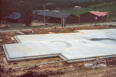 Eltham District Historical Society Inc
Photograph, Concrete slab from backyard
14 Stokes Place (Lot 83) was the home of Peter and Carla Vermey. The land was purchased in May 1979 and construction commenced September 1979. The home was built by Peter and Carla Vermey after the developer, Macquarie Builders went bankrupt. Sold October 2017 by Morrison and Kleeman Real Estate. Stokes Place was part of the Stokes Orchard Estate which was developed from the break-up of the the orchard owned by Frank Stokes who lived on the northeast corner of Nyora Road and Eucalyptus Road. His daughter Beryl advised that the Shire had levied a rate assessment on individual parcels of land within the orchard which became unaffordable resulting in its sub-division and sell off. The Stokes Orchard Estate was developed by Macquarie Builders in two stages starting with stage 1 in 1976. Stokes Place was part of Stage 2 in 1979. The Estate was bounded between Nyora Road, Eucalyptus Road, Diosma Road and Stokes Place. The original orchard only just reached the left most portions of Stokes Place and did not go fully up to Diosma, rather to just beyond the extant of Stokes Place. Stokes Place was known within the family as "The Oats" as that is where they grew oats. Frank Stokes moved to Eltham c.1945 after visiting Harold Bird to view his orchard, located diagonally opposite Stokes Orchard from the intersection of Eucalyptus Road, Pitt Street and Nyora Road. It was on Harold Bird's recommendation that Frank purchased the land.The Stokes Orchard Estate collection is typical of housing developments of the late 1970s and 1980s. It was one of the earliest estates in Eltham following the nearby Woodridge Estate development.Digital fileScanned by EDHS from 49 x 35mm colour transparencies provided on loanstokes place, eltham, stokes orchard, stokes orchard estate, streets, houses, peter and carla vermey -
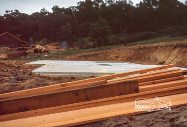 Eltham District Historical Society Inc
Photograph, Concrete slab from driveway
14 Stokes Place (Lot 83) was the home of Peter and Carla Vermey. The land was purchased in May 1979 and construction commenced September 1979. The home was built by Peter and Carla Vermey after the developer, Macquarie Builders went bankrupt. Sold October 2017 by Morrison and Kleeman Real Estate. Stokes Place was part of the Stokes Orchard Estate which was developed from the break-up of the the orchard owned by Frank Stokes who lived on the northeast corner of Nyora Road and Eucalyptus Road. His daughter Beryl advised that the Shire had levied a rate assessment on individual parcels of land within the orchard which became unaffordable resulting in its sub-division and sell off. The Stokes Orchard Estate was developed by Macquarie Builders in two stages starting with stage 1 in 1976. Stokes Place was part of Stage 2 in 1979. The Estate was bounded between Nyora Road, Eucalyptus Road, Diosma Road and Stokes Place. The original orchard only just reached the left most portions of Stokes Place and did not go fully up to Diosma, rather to just beyond the extant of Stokes Place. Stokes Place was known within the family as "The Oats" as that is where they grew oats. Frank Stokes moved to Eltham c.1945 after visiting Harold Bird to view his orchard, located diagonally opposite Stokes Orchard from the intersection of Eucalyptus Road, Pitt Street and Nyora Road. It was on Harold Bird's recommendation that Frank purchased the land.The Stokes Orchard Estate collection is typical of housing developments of the late 1970s and 1980s. It was one of the earliest estates in Eltham following the nearby Woodridge Estate development.Digital fileScanned by EDHS from 49 x 35mm colour transparencies provided on loanstokes place, eltham, stokes orchard, stokes orchard estate, streets, houses, peter and carla vermey -
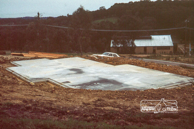 Eltham District Historical Society Inc
Photograph, Concrete slab from north elevation
14 Stokes Place (Lot 83) was the home of Peter and Carla Vermey. The land was purchased in May 1979 and construction commenced September 1979. The home was built by Peter and Carla Vermey after the developer, Macquarie Builders went bankrupt. Sold October 2017 by Morrison and Kleeman Real Estate. Stokes Place was part of the Stokes Orchard Estate which was developed from the break-up of the the orchard owned by Frank Stokes who lived on the northeast corner of Nyora Road and Eucalyptus Road. His daughter Beryl advised that the Shire had levied a rate assessment on individual parcels of land within the orchard which became unaffordable resulting in its sub-division and sell off. The Stokes Orchard Estate was developed by Macquarie Builders in two stages starting with stage 1 in 1976. Stokes Place was part of Stage 2 in 1979. The Estate was bounded between Nyora Road, Eucalyptus Road, Diosma Road and Stokes Place. The original orchard only just reached the left most portions of Stokes Place and did not go fully up to Diosma, rather to just beyond the extant of Stokes Place. Stokes Place was known within the family as "The Oats" as that is where they grew oats. Frank Stokes moved to Eltham c.1945 after visiting Harold Bird to view his orchard, located diagonally opposite Stokes Orchard from the intersection of Eucalyptus Road, Pitt Street and Nyora Road. It was on Harold Bird's recommendation that Frank purchased the land.The Stokes Orchard Estate collection is typical of housing developments of the late 1970s and 1980s. It was one of the earliest estates in Eltham following the nearby Woodridge Estate development.Digital fileScanned by EDHS from 49 x 35mm colour transparencies provided on loanstokes place, eltham, stokes orchard, stokes orchard estate, streets, houses, peter and carla vermey -
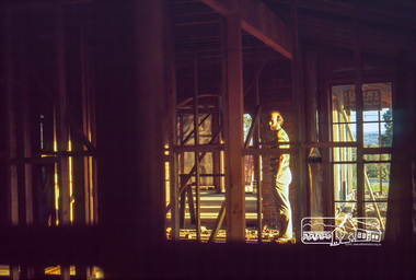 Eltham District Historical Society Inc
Photograph, Peter Vermey in hall, studs still exposed
14 Stokes Place (Lot 83) was the home of Peter and Carla Vermey. The land was purchased in May 1979 and construction commenced September 1979. The home was built by Peter and Carla Vermey after the developer, Macquarie Builders went bankrupt. Sold October 2017 by Morrison and Kleeman Real Estate. Stokes Place was part of the Stokes Orchard Estate which was developed from the break-up of the the orchard owned by Frank Stokes who lived on the northeast corner of Nyora Road and Eucalyptus Road. His daughter Beryl advised that the Shire had levied a rate assessment on individual parcels of land within the orchard which became unaffordable resulting in its sub-division and sell off. The Stokes Orchard Estate was developed by Macquarie Builders in two stages starting with stage 1 in 1976. Stokes Place was part of Stage 2 in 1979. The Estate was bounded between Nyora Road, Eucalyptus Road, Diosma Road and Stokes Place. The original orchard only just reached the left most portions of Stokes Place and did not go fully up to Diosma, rather to just beyond the extant of Stokes Place. Stokes Place was known within the family as "The Oats" as that is where they grew oats. Frank Stokes moved to Eltham c.1945 after visiting Harold Bird to view his orchard, located diagonally opposite Stokes Orchard from the intersection of Eucalyptus Road, Pitt Street and Nyora Road. It was on Harold Bird's recommendation that Frank purchased the land.The Stokes Orchard Estate collection is typical of housing developments of the late 1970s and 1980s. It was one of the earliest estates in Eltham following the nearby Woodridge Estate development.Digital fileScanned by EDHS from 49 x 35mm colour transparencies provided on loanstokes place, eltham, stokes orchard, stokes orchard estate, streets, houses, peter and carla vermey -
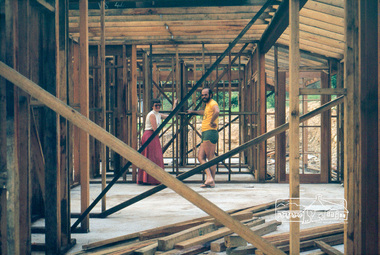 Eltham District Historical Society Inc
Photograph, Peter and Carla Vermey in family area, studs still exposed
14 Stokes Place (Lot 83) was the home of Peter and Carla Vermey. The land was purchased in May 1979 and construction commenced September 1979. The home was built by Peter and Carla Vermey after the developer, Macquarie Builders went bankrupt. Sold October 2017 by Morrison and Kleeman Real Estate. Stokes Place was part of the Stokes Orchard Estate which was developed from the break-up of the the orchard owned by Frank Stokes who lived on the northeast corner of Nyora Road and Eucalyptus Road. His daughter Beryl advised that the Shire had levied a rate assessment on individual parcels of land within the orchard which became unaffordable resulting in its sub-division and sell off. The Stokes Orchard Estate was developed by Macquarie Builders in two stages starting with stage 1 in 1976. Stokes Place was part of Stage 2 in 1979. The Estate was bounded between Nyora Road, Eucalyptus Road, Diosma Road and Stokes Place. The original orchard only just reached the left most portions of Stokes Place and did not go fully up to Diosma, rather to just beyond the extant of Stokes Place. Stokes Place was known within the family as "The Oats" as that is where they grew oats. Frank Stokes moved to Eltham c.1945 after visiting Harold Bird to view his orchard, located diagonally opposite Stokes Orchard from the intersection of Eucalyptus Road, Pitt Street and Nyora Road. It was on Harold Bird's recommendation that Frank purchased the land.The Stokes Orchard Estate collection is typical of housing developments of the late 1970s and 1980s. It was one of the earliest estates in Eltham following the nearby Woodridge Estate development.Digital fileScanned by EDHS from 49 x 35mm colour transparencies provided on loanstokes place, eltham, stokes orchard, stokes orchard estate, streets, houses, peter and carla vermey -
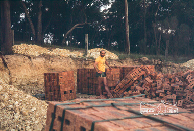 Eltham District Historical Society Inc
Photograph, Peter Vermey in excavation for garage with with stacks of bricks
14 Stokes Place (Lot 83) was the home of Peter and Carla Vermey. The land was purchased in May 1979 and construction commenced September 1979. The home was built by Peter and Carla Vermey after the developer, Macquarie Builders went bankrupt. Sold October 2017 by Morrison and Kleeman Real Estate. Stokes Place was part of the Stokes Orchard Estate which was developed from the break-up of the the orchard owned by Frank Stokes who lived on the northeast corner of Nyora Road and Eucalyptus Road. His daughter Beryl advised that the Shire had levied a rate assessment on individual parcels of land within the orchard which became unaffordable resulting in its sub-division and sell off. The Stokes Orchard Estate was developed by Macquarie Builders in two stages starting with stage 1 in 1976. Stokes Place was part of Stage 2 in 1979. The Estate was bounded between Nyora Road, Eucalyptus Road, Diosma Road and Stokes Place. The original orchard only just reached the left most portions of Stokes Place and did not go fully up to Diosma, rather to just beyond the extant of Stokes Place. Stokes Place was known within the family as "The Oats" as that is where they grew oats. Frank Stokes moved to Eltham c.1945 after visiting Harold Bird to view his orchard, located diagonally opposite Stokes Orchard from the intersection of Eucalyptus Road, Pitt Street and Nyora Road. It was on Harold Bird's recommendation that Frank purchased the land.The Stokes Orchard Estate collection is typical of housing developments of the late 1970s and 1980s. It was one of the earliest estates in Eltham following the nearby Woodridge Estate development.Digital fileScanned by EDHS from 49 x 35mm colour transparencies provided on loanstokes place, eltham, stokes orchard, stokes orchard estate, streets, houses, peter and carla vermey -
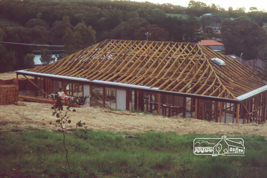 Eltham District Historical Society Inc
Photograph, Carla Vermey in backyard, roof not yet tiled
14 Stokes Place (Lot 83) was the home of Peter and Carla Vermey. The land was purchased in May 1979 and construction commenced September 1979. The home was built by Peter and Carla Vermey after the developer, Macquarie Builders went bankrupt. Sold October 2017 by Morrison and Kleeman Real Estate. Stokes Place was part of the Stokes Orchard Estate which was developed from the break-up of the the orchard owned by Frank Stokes who lived on the northeast corner of Nyora Road and Eucalyptus Road. His daughter Beryl advised that the Shire had levied a rate assessment on individual parcels of land within the orchard which became unaffordable resulting in its sub-division and sell off. The Stokes Orchard Estate was developed by Macquarie Builders in two stages starting with stage 1 in 1976. Stokes Place was part of Stage 2 in 1979. The Estate was bounded between Nyora Road, Eucalyptus Road, Diosma Road and Stokes Place. The original orchard only just reached the left most portions of Stokes Place and did not go fully up to Diosma, rather to just beyond the extant of Stokes Place. Stokes Place was known within the family as "The Oats" as that is where they grew oats. Frank Stokes moved to Eltham c.1945 after visiting Harold Bird to view his orchard, located diagonally opposite Stokes Orchard from the intersection of Eucalyptus Road, Pitt Street and Nyora Road. It was on Harold Bird's recommendation that Frank purchased the land.The Stokes Orchard Estate collection is typical of housing developments of the late 1970s and 1980s. It was one of the earliest estates in Eltham following the nearby Woodridge Estate development.Digital fileScanned by EDHS from 49 x 35mm colour transparencies provided on loanstokes place, eltham, stokes orchard, stokes orchard estate, streets, houses, peter and carla vermey -
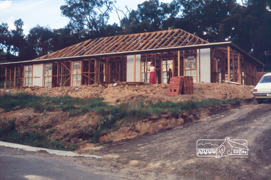 Eltham District Historical Society Inc
Photograph, Carla Vermey on front verandah, framing stage
14 Stokes Place (Lot 83) was the home of Peter and Carla Vermey. The land was purchased in May 1979 and construction commenced September 1979. The home was built by Peter and Carla Vermey after the developer, Macquarie Builders went bankrupt. Sold October 2017 by Morrison and Kleeman Real Estate. Stokes Place was part of the Stokes Orchard Estate which was developed from the break-up of the the orchard owned by Frank Stokes who lived on the northeast corner of Nyora Road and Eucalyptus Road. His daughter Beryl advised that the Shire had levied a rate assessment on individual parcels of land within the orchard which became unaffordable resulting in its sub-division and sell off. The Stokes Orchard Estate was developed by Macquarie Builders in two stages starting with stage 1 in 1976. Stokes Place was part of Stage 2 in 1979. The Estate was bounded between Nyora Road, Eucalyptus Road, Diosma Road and Stokes Place. The original orchard only just reached the left most portions of Stokes Place and did not go fully up to Diosma, rather to just beyond the extant of Stokes Place. Stokes Place was known within the family as "The Oats" as that is where they grew oats. Frank Stokes moved to Eltham c.1945 after visiting Harold Bird to view his orchard, located diagonally opposite Stokes Orchard from the intersection of Eucalyptus Road, Pitt Street and Nyora Road. It was on Harold Bird's recommendation that Frank purchased the land.The Stokes Orchard Estate collection is typical of housing developments of the late 1970s and 1980s. It was one of the earliest estates in Eltham following the nearby Woodridge Estate development.Digital fileScanned by EDHS from 49 x 35mm colour transparencies provided on loanstokes place, eltham, stokes orchard, stokes orchard estate, streets, houses, peter and carla vermey