Showing 11136 items
matching planning
-
 Port Melbourne Historical & Preservation Society
Document - Beacon Cove Neighbourhood Association (BCNA) records, Beacon Cove Neighbourhood Association, 2006 - 2014
Beacon Cove Neighbourhood Association is a successor organisation of the Swallow Street & Beacon Cove Residents Association.Box1 contains historical records of the Beacon Cove Neighbourhood Association (BCNA) including minutes of Annual General Meetings, newsletters, budgets, correspondence, Princes Pier restoration, Sandridge Beach master plan & Station Pier crane restoration.beacon cove neighbourhood association, bcna, swallow street & beacon cove residents association, princes pier, station station, sandridge beach -
Surrey Hills Historical Society Collection
Work on paper - Vertical file, Back Creek
1. ‘Plan rainchecked for creek impact’, Boroondara Review, 13.3.2013 (2 pages). 2. ‘Pipe dreams run their course’, (Boroondara Review ?) 17.4.2013 (1 page). 3. 4 colour photos taken in 1983 (1 page). -
 Bendigo Historical Society Inc.
Map - COMET MINE - PLAN OF COMET MINE
Plan of the Comet Mine on the Hustler's Line of Reefs Bulletin No 33, Plate No XXIV signed by H S Whitelaw, Underground Survey Office Bendigo, September 1913. Upper and Lower Levels and approximate boundaries shown. Depths shown.Geological Survey of Victoriamining, parish map, hustler's line of reefs, comet mine plan bulletin no 33 plate no xxiv -
Glen Eira Historical Society
Plan - Wilks Street, 17, Caulfield North
Drawn plan of house at 17 Wilkes Street Caulfield with room dimensions, squarage and content, and fixtures with tenants name J. Barrett.caulfield north, wilkes street, barrett j., brick houses -
 Greensborough Historical Society
Booklet - Report, TTM Consulting Pty Ltd, Shire of Diamond Valley: Greensborough District Centre: "East-side" development application: traffic & parking impact report, 1992, 1992_04
A summary of traffic ad parking impacts of the Greensborough District Centre in 1992, with plans for the development of the East side of Main Street Greensborough.14 pages text and 11 pages black and white line drawings. greensborough district centre, main street greensborough, traffic, parking -
 Greensborough Historical Society
Leaflet, Colin Brooks, Colin Brooks (politician), 2022
Political campaign brochure from Colin Brooks MP detailing Labor plans for power costs, free kinder, TAFE and transportDouble sided coloured brochurecolin brooks, victoria - politics and government -
 Greensborough Historical Society
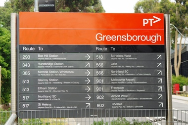
Photograph - Photograph - Digital Image, Marilyn Smith, Greensborough Railway Station signage 2021, 2021_02
Photographs of Greensborough Railway Station signage in February 2021, before the planned rebuild of the station as part of the Hurstbridge rail line upgrade. 2 Colour digital photographsgreensborough railway station, hurstbridge rail line upgrade -
 Greensborough Historical Society
Letter, Banyule City Council, A new playground and bike education track for Delta Reserve, 17/02/2020
Banyule City Council letter informing residents of plans to upgrade Delta Reserve, Greensborough, including a new bike education track1 p. letter on Banyule City Council letterheaddelta road reserve, bike education, parks and reserves, banyule city council -
 Greensborough Historical Society
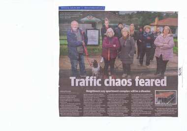
Newspaper Clipping, Diamond Valley Leader, Traffic chaos feared, 26/06/2019
A plan to develop a six-storey apartment complex next to Greensborough station will cause a "chaotic traffic disaster", concerned residents say.News article 1 page, black text and colour image.greensborough station, apartment complex, poulter avenue greensborough, banyule city council -
 Greensborough Historical Society
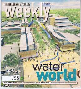
Newspaper, Fairfax Media, Heidelberg and Valley Weekly. August 29 2006, 29/08/2006
This issue of the Heidelberg and Valley Weekly, (August 29 2006) includes a double page feature on the planned redevelopment of the Greensborough Town Centre.55 pages, colour images and black text. greensborough town centre, main street greensborough -
 Greensborough Historical Society
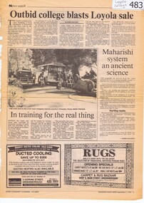
Newspaper Clipping, Diamond Valley News, Outbid college blasts Loyola sale, and, Panel backs shire on Loyola, 07/09/1994
These articles detail the changes to planning regulations around the Loyola seminary site and its sale by the state government to the Maharishi organisation in 1994.These articles show the community interest in the Loyola site and its buildings and form part of the ongoing history of this site.2 newspaper articles. Text only.loyola college, loyola seminary watsonia, ignatian, maharishi -
Federation University Historical Collection
Book, University of Ballarat - Assessment Task: Group Project Assignment, Community & Organisational Plan, 2006
University of Ballarat - Assessment Task: Group Project Assignment, Community & Organisational Plan. Hepburn Shire Council. Student Research Project.White bound book of 30 pages.university of ballarat, mary hollick, hepburn shire council, casey nelson, ash hardy, erin ward, melissa russell, josh wood, importance of tourism to the local economy, assessment of local community issues, attitudes and involvement, assessment of organisational structures and relationships, assessment of the role and effectiveness of the local and regional tourism associations, identification of strategies to achieve better co-ordination of all stakeholders in tourism, conclusion, references, daylesford regional tourism association, hepburn regional tourism association, local tourism assocation, macedon ranges regional tourism association, regional tourism association, judith bedford -
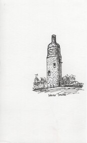 Rutherglen Historical Society
Ink sketch, Pat Robinson, Water Tower, c1990
Ink sketches of Rutherglen landmarks and old buildings produced by local artist Pat Robinson for planned Historic Walk brochure (not used)One of a series of black and white ink sketches, on paper, of Rutherglen landmarks. This one showing the water tower with the structure that was added to the top to make it look like a wine bottle. pat robinson, buildings, artist, water tower, wine bottle -
Moorabbin Air Museum
Document (Item) - CAC Project Report on Experimental Fighter Design, Project Report ADH - P1
Proposed fighter would be powered by a Twin-Row Wasp Engine, and these reports seem to be the early stages of planning to build the CAC Boomerang. -
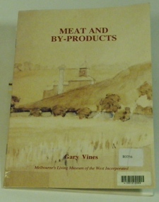 Melbourne's Living Museum of the West
Booklet, Melbourne's Living Museum of the West, Meat and By-Products, 1993
The meat industry and animal by-product works of Melbourne's West, in the series "Interpreting the Cultural Landscape", with the assistance of the Department of Planning and Development, VictoriaThe Australian Meat Preserving Company was established on the banks of the Maribyrnong River in 1870 on the site of boiling works dating from the 1840s.32 page booklet, A5, Cover illustration of Raleigh's boiling down works on the Maribyrnong River, from water-colour by Greeves C. 1850s Title: Meat and By-Products Author: Gary Vines Melbourne's Living Museum of the West Inc.western suburbs, meat industry -
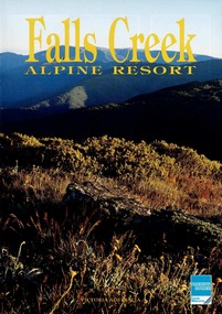 Falls Creek Historical Society
Magazine - Falls Creek Alpine Resort
Part of an annual marketing campaign, this booklet was designed to provide information for planning a holiday or short visit to Falls Creek for the summer season.This item is important as it documents seasonal activities at Falls Creek Alpine ResortMagazine titled Falls Creek Alpine Resort. Front cover is an image of a grassed hill area with Falls Creek Alpine Resort titled centre top in yellow, American Express logo bottom right and blue back cover with Falls Creek Chamber of Commerce and American Express at bottom of page. Six internal pages with outdoor images and accommodation information for Summer in Falls Creek. falls creek summer, falls creek marketing, accommodation falls creek -
 City of Kingston
Pamphlet - Colour, H. R. Hill & Co, Walker's Estate, Cheltenham for sale by public auction, c. 1923
Sales plan for land in the suburb of Cheltenham, encompassing both sides of Walker Grove, a section of Centre Dandenong Rd and Axelton St. The developing urban area of Cheltenham within the City of Kingston. This land sale pamphlet illustrates the subdivision of land within the municipality and the changing demographic of the district as new houses are constructed.Black and white pamphlet advertising for private sale the Station Entrance Estate, Highett. Incorporates a map of the estate bordered by Wickham Road, Railway Parade, Highett Road and Point Nepean Road.Handwritten in black pen on subdivision map: 'x' written on subdivisions 2, 3, 8-11, 15-17, 19. Potentially indicating that these properties did not sell at auction. Handwritten in black pen on subdivision map: assumed sale price on subdivisions 1, 4-7, 12-14, 18, 20-31. land sales, cheltenham, estate -
 City of Kingston
Pamphlet - Colour, Roy Dunn Pty. Ltd, Subdivisional auction of Highett Station Estate, c.1924
Sales plan for land in the suburb of Highett, bounded by Worthing Road, and the Melbourne to Frankston Electric Railway Line, including LePage Street. The developing urban area of Highett within the City of Kingston. This land sale pamphlet illustrates the subdivision of land within the municipality and the changing demographic of the district as new houses are constructed close to infrastructure.Colour pamphlet advertising a subdivisional auction of the Highett Station Estate. Incorporates a map of the estate bordered by Worthing Road and the Melbourne to Frankston Electric Railway, and including LePage Street. Handwritten in black ink on front cover: Late LePage / Wickham Rdland sales, estate, highett -
 City of Kingston
Pamphlet - Colour, Smith, Nicolson Pty. Ltd, Cheltenham Estate, c. 1890
Sales plan for land in the suburb of Cheltenham, bounded by Point Nepean Road and Swinden Avenue, including Evesham Road and Wallingford Street.The developing urban area of Cheltenham within the City of Kingston. This land sale pamphlet illustrates the subdivision of land within the municipality and the changing demographic of the district as new houses are constructed close to infrastructure.Colour pamphlet advertising for private sale Cheltenham Estate. Incorporates a map of the estate bordered by Point Nepean Road and Swinden Avenue, including Evesham Road, and Wallingford Street.Handwritten in red ink on subdivison 45: D / H Handwritten in red ink on subdivision 46: Anderson Handwritten in red ink on subdivisions 88, 87, 77 and 56: K / D Handwritten in red ink on subdivision 86: D / H Handwritten in red ink on subdivision 63 and 62: Hudson Handwritten in red ink on subdivision 59 [indecipherable] Handwritten in red ink on subdivision 58: aB Handwritten in red ink on subdivision 57: Lavosh Handwritten in grey pencil on subdivision 28, 26, 24, 67, 58, 49: B Handwritten in grey pencil on subdivisions 78 and 79: Paint Handwritten in purple pencil on subdivsion 114 and 86: B land sales, estate, cheltenham -
Bialik College
Mixed media (Item) - 2000 Art Tech images
Floor plans and visualisation materials at Bialik College, Art and Technology, in 2000. Please contact [email protected] to request access to this record. x5 Bialik Art & Tech Images (hi-Res and Low Res)2000s, 2000, art, technology, building, bialik college -
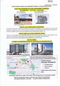 Greensborough Historical Society
Document - Planning Document, Diamond Village Apartment Complex, 2019
A collection of documents discussing opposition to the Diamond Valley Apartment Complex, a high-rise apartment development planned for Nepean Street Greensborough.13 pages of Text with coloured photographs and mapdiamond village apartment complex, building permits, nepean street greensborough -
 Whitehorse Historical Society Inc.
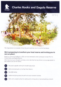
Document, Charles Rooks and Dagola Reserve, 19/03/2025
The Whitehorse City Council is proposing to transform the Charles Rooks and Dagola Reserve and is inviting residents to view plans and comment by 17/03/2025non-fictionThe Whitehorse City Council is proposing to transform the Charles Rooks and Dagola Reserve and is inviting residents to view plans and comment by 17/03/2025dagola avenue nunawading, charles rooks and dagola reserve, pipe line reserve, parks and reserves, lorikeet avenue nunawading -
Bialik College
Mixed media (series) - Documents and images relating to logos and building plans, c.2000s
-
 Kew Historical Society Inc
Plan - Subdivision Plan, Old Kew Golf Links Estate - Third Section, 1920-1929
Pru Sanderson, in her groundbreaking ‘City of Kew Urban Conservation Study : Volume 2 - Development History’ (1988), summarised the periods of urban development and subdivisions of land in Kew. The periods that she identified included 1845-1880, 1880-1893, 1893-1921, 1921-1933, 1933-1943, and Post-War Development. These periods were selected as they represented periods of rapid growth or decline in urban development. An obvious starting point for Sanderson’s groupings involved population growth and the associated economic cycles. These cycles also highlighted urban expansion onto land that was predominantly rural, although in other cases it represented the decline and breakup of large estates. A number of the plans in the Kew Historical Society’s collection can also be found in other collections, such as those of the State Library of Victoria and the Boroondara Library Service. A number are however unique to the collection.The Kew Historical Society collection includes almost 100 subdivision plans pertaining to suburbs of the City of Melbourne. Most of these are of Kew, Kew East or Studley Park, although a smaller number are plans of Camberwell, Deepdene, Balwyn and Hawthorn. It is believed that the majority of the plans were gifted to the Society by persons connected with the real estate firm - J. R. Mathers and McMillan, 136 Cotham Road, Kew. The Plans in the collection are rarely in pristine form, being working plans on which the agent would write notes and record lots sold and the prices of these. The subdivision plans are historically significant examples of the growth of urban Melbourne from the beginning of the 20th Century up until the 1980s. A number of the plans are double-sided and often include a photograph on the reverse. A number of the latter are by noted photographers such as J.E. Barnes.When the old Kew Golf Links was subdivided in the mid 1920s, the developers were able to break the sale into sections. The third section included eighty lots. The lots faced Kilby Road, Kodak Avenue, Belford Road, Baker Avenue, Mathers Avenue, and White Avenue. [Kodak Avenue was renamed Page Avenue at a later date].The ‘Kew Conservation Study (1988) notes that ‘On the subdivision plan, Kodak’s involvement is commemorated by the naming of the streets after Company directors, and their decision to not proceed with the construction of the factory is explained as a response to the increase in the value of the land. This explanation may have been Estate Agent’s hyperbole, as the Kodak Company records suggest that the land, with its wide creek gully, was unsuitable and too small for its purposes.subdivision plans - kew, old kew golf links estate - third section -
Glen Eira Historical Society
Map - Kilvington Baptist Girls Grammar School
One hard copy and one photocopy of Kilvington Baptist Girls Grammar School Planning brief dated October 1982. The brief details the current needs of the school and has been written to spell out a forward plan for development in the foreseeable future. It includes data on the current forecast enrolments at primary and secondary levels as well as the current and future use and development of the buildings and their use. Author of the brief is unknown.kilvington baptist girls grammar school, schools, ormond, lillimur road, walsh street, ormond girls school, kilvington girls grammar school, leila road, katandra road, ulupna road -
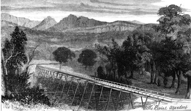 Stawell Historical Society Inc
Drawing, Stawell Water Supply Bovine Aqueduct 1881 -- Sketch
Sketches of Stawell Water Supply Bovine Aqueduct October 5th 1881. The Grampian scheme planned by the the Borough Engineer John D'Alton. D'Alton's suggestion was that the water be carried from the source in an open channel two miles, then in a flume of timber. Later surveyed and planned a tunnel on a good line - to reduce the flume 72 miles and the main to Stawell to 15 miles. This sketch (illustrated Australian News October 5, 1881).Black and white photograph of a sketch a bush scene with mountains in background. The sketch depicts a trestle bridge construction. The Bovine Aqueduct stawell water supply -
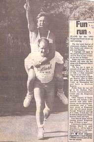 Ringwood and District Historical Society
Newspaper, Scrapbook Clipping, Library Collection, Ringwood, Victoria
Newspaper Clipping from "The Mail", 3-9-93, Page 3 . Fun RunPlans for the 1993 Ringwood Festival were up and running.The two week festival contained community displays, family fun, theatre and cabaret. A highlight was the annual Ringwood Fun Run. Frankie J Holden opened the day along with Ringwood Mayor, Greg Adkins. -
 Vision Australia
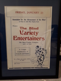
Poster - Object, Perce Park (illustrator), The Blind Variety Entertainers, 1925
A series of handbills produced to advertise upcoming concerts for the Blind Variety Entertainers, who toured around the state raising funds for the Association for the Advancement of the Blind. Combining comedy, songs, impersonations, acrobatics and musical interludes, these performers toured annually and visited various regional towns across the state of Victoria.1 rectangular white handbill with red and blue text with blue illustrationFriday January 23 Association for the Advancement of the Blind and Home for Adult Blind, Brighton Beach Presents The Blind Variety Entertainers The Most Popular Company now on tour A Unique Combination of Comedy and Classics It's a Show you cannot afford to miss Box Planassociation for the blind, marketing -
 Melbourne Tram Museum
Book, Melbourne & Metropolitan Tramways Board (MMTB), "MMTB Electric Tramways and Motor Omnibuses Sections and Fares", Aug. 1971
Red cloth covered bound book, 116 pages, plus printed end sheets used in covers, titled "MMTB Electric Tramways and Motor Omnibuses Sections and Fares", dated August 1971. Book consists of four sections, bound with sewn cloth binding on the outside with glued white paper end covers. Details the various section stages and fares for each tram and bus route, General instructions, concession fares and has photos or drawings of the various special tickets, eg passes or prepaid tickets. Second copy added 14-12-15 from Donation of Norm Cross - 11-10-2009.Pages 103 - 105 have been hand amended - re Limbless and Disabled Soldiers. Has number "4781058" in top left hand corner of the first page. Copy 2 - has "Planning Engineer 24/12/71" in ink on inside front cover.trams, tramways, tickets, fares, sections, passes -
 Federation University Historical Collection
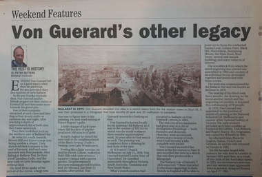
Document, Dianne Campbell, Ballarat History Research Folders, c2000-2021
Two folders of research notes on Ballarat Lawyers, including newspaper clippings, website information, etc .1) newspaper clippings, Plan of Township and Extension of Ballarat County of Grenville 1855, Plan of the Township of Ballarat, Ballarat District from Victoria and It's Metropolis, American Republicanism and the Disturbances on the Victorian Goldfields, Sovereign Remedies, History of the Mechanics' Institute (Spielvogel), Irish in Australia. .2) Curiosity Shop, Mary Amelia Cuthbert; letter from MR to WLR 1860), Ulysses Bound (Richardson)`, Henry Handel Richrdson, Gas in Ballarat, George Binsteadballarat lawyers, di campbell goldfields lawyers collection, ballarat, gas, walter richardson, ballarat high school centenary, courier articles by anne beggs sunter, courier articles by dorothy wickham, courier articles by peter butters