Showing 10832 items
matching maps
-
 Moorabbin Air Museum
Booklet - Moorabbin Air Museum, Moorabbin Airport, Moorabbin Air Museum
The booklet is a brief coverage of the Moorabbin Air Museum, circulated roughly in the 70's. It covers the founding of the Air Museum and the planes at the time.Light blue booklet with a black and white naval plane on the front and a simplified map on the back.non-fictionThe booklet is a brief coverage of the Moorabbin Air Museum, circulated roughly in the 70's. It covers the founding of the Air Museum and the planes at the time.air museum, air history, victoria, moorabbin -
![Triangle of Tranquility: 150 years of the Boroondara (Kew) Cemetery 1859-2009 / [by] Friends of Boroondara (Kew) Cemetery](/media/collectors/550653872162f11fb04854aa/items/5d0350f321ea7b09505dbdfa/item-media/5ebbc43621ea670348e81b9c/item-fit-380x285.jpg) Kew Historical Society Inc
Kew Historical Society IncBook, Triangle of Tranquility: 150 years of the Boroondara (Kew) Cemetery 1859-2009 / [by] Friends of Boroondara (Kew) Cemetery, 2008
88 p., [4] p. of plates : ill. (some col.), map, ports. 30cmnon-fictionboroondara general (kew) cemetery, cemeteries - victoria -
![Aborigines in Colonial Victoria 1835-86 / [by] M.F. Christie](/media/collectors/550653872162f11fb04854aa/items/5ed04cf1dcf9cd08346bc646/item-media/5ed04db8dcf9cd08346bcaf0/item-fit-380x285.jpg) Kew Historical Society Inc
Kew Historical Society IncBook, Sydney University Press, Aborigines in Colonial Victoria 1835-86, 1979
General account of pre-contact Aborigines; white colonisation and violent conflict; racial attitudes of early settlers; native police; government policy; mission work; foundation of reserves; Coranderrk.Sydney : Sydney University Press, 1979 viii,227p., 12p. of plates : maps ; 22cm. non-fictionGeneral account of pre-contact Aborigines; white colonisation and violent conflict; racial attitudes of early settlers; native police; government policy; mission work; foundation of reserves; Coranderrk.aboriginal australians -- victoria -- treatment -- history., aboriginal and torres straight islander -
 Kew Historical Society Inc
Book, Libraries Board of South Australia, An historical journal of the transactions at Port Jackson and Norfolk Island with the discoveries which have been made in New South Wales and in the southern ocean since the publication of Phillip's voyage, compiled from the official papers, including the journals of Governors Phillip and King and of Lieut. Ball, and the voyages from the first sailing of the Sirius in 1787, to the return of that ship's company to England in 1792, 1968
Facsimile of journals of the voyages from England to Port Jackson and Norfolk Island and return by Governors Phillip and King, and Lieut. Ball 1787-1792, including maps, charts, drawings and tables. Reproduced from a copy held in the State Library of South Australia originally published in 1793.583 p., <16> leaves of plates (2 folded) : ill., maps, 1 port. non-fictionFacsimile of journals of the voyages from England to Port Jackson and Norfolk Island and return by Governors Phillip and King, and Lieut. Ball 1787-1792, including maps, charts, drawings and tables. Reproduced from a copy held in the State Library of South Australia originally published in 1793.norfolk isalnd - history, port jackson, hunter, john (1737-1821) -
Canterbury History Group
Map - Township of Canterbury and Township of Balwyn, 1900
Copies of the maps of Canterbuy and Balwyn copied and enlarged from Sands and Mcdougall Directory 1900canterbury, balwyn, sands and mcdougall directories -
 Kilmore Historical Society
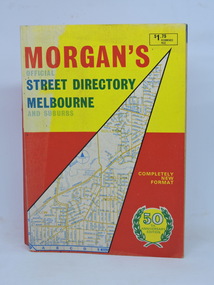
Morgan's Street Directory Melbourne, Morgan's Official Street Directory Melbourne and Suburbs, c1966
c1966 Melbourne Street Directory.Soft card cover. 150 maps plus Index. 380 pp. Good condition.Nilmelbourne street directory -
 Mont De Lancey
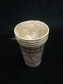
Paper Cup
Commemorating 1956 Melbourne Olympic GamesSet of four paper cups - white, red and blue with Athletes, flags and Australian map.cups, disposable cups -
 Phillip Island Conservation Society Inc.
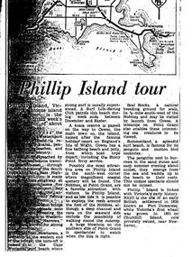
Work on paper - Photocopy of newspaper cutting, "Phillip Island tour", circa 1950s?
The article relates the journalist's visit to Phillip Island, starting from Melbourne and describing features along the way, then at San Remo on mainland side of Phillip Island bridge, then Newhaven on the other. Other places visited include the main town of Cowes, the jetty and beach there, and the Nobbies (Point Grant), with views of the Seal Rocks offshore through telescope at the Nobbies. The writer also visited Summerland beach, described as a surf beach, with penguin and mutton bird rookeries. While not specifically referring to the Penguin Parade, the writer says the spectacle of seeing the penguins coming ashore is not to be missed. The brief military colony at Rhyll and the first Victorian 'garden' planted at Churchill Island in 1801 are also mentionedArticle is significant because it is an early (1950s?) tourist guide to Phillip Island's most popular tourist destinations. 3 column text under map of Phillip Island. Black print on white paper. phillip island, newhaven, , westernport, surf beaches phillip island, summerland beach, penguins, mutton birds, the nobbies, point grant, seal rocks, cowes, nobbies blowhole, rhyll, churchill island, nobbies telescope -
 Ringwood RSL Sub-Branch
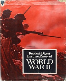
Book - Readers Digest Illustrated story of Word War II, 1970
Hard cover with dust cover. 536 printed pages containing text, maps and photographs -
 Ringwood RSL Sub-Branch
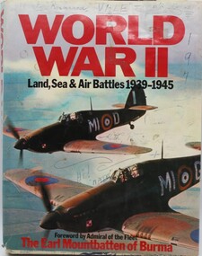
Book World War 2, World War 2 - Land Sea and Air Battles, 1977
Hard Cover with 253 pages containing colour, black and white maps and text.Assorted notingsAssorted notings on page 6.....VX52302. Additional notings also inside dust cover. -
 St Patrick's Old Collegians Association (SPOCA)
Photograph - Teachers, Jesuits
-
 Melbourne Tram Museum
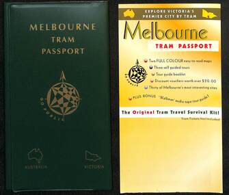
Booklet - Folder - sample, Go Public, "Melbourne Tram Passport", 1995
Possibly a sample of a product, Melbourne Tram Passport, that was compiled or put together by Go Public in 1995 as a promotion to use Melbourne trams and receive discounts at various venues. No evidence is known of its actual use in practice. On the last page of the Guide Book are the names of David Miller and Frank Pallay and Go Public's Elsternwick PO Address. Similar to the "Melbourne Met Pass" of 1988 - see item 2843 Yields information about the concept of a tourist travel promotion using Melbourne's trams.Green plastic partitioned folded containing sample tickets, map, pamphlet and guide books.trams, tramways, melbourne tram passport, tickets, the met, public transport -
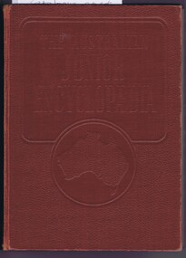 Greensborough Historical Society
Book, The Australian Educational Foundation, The Australian Junior Encyclopaedia, 1951
An Australian history encyclopedia covering history, flora and fauna, industry, communications and geography.3 volumes, illustrations (some colour), maps, Leather type hard bound covers.encyclopedias, encyclopedias - australia -
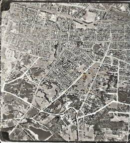 Bendigo Historical Society Inc.
Photograph - AERIAL SURVEY BENDIGO BASE MAP - RUN 12
Black and white photograph which is an aerial survey Bendigo base map - run 12. Inscriptions: Vic 1583. State Aerial Survey Bendigo Base Map Project - Run 12. 16/3/1967, 5600ASL on front. The photograph shows areas of Kennington and Flora Hill. Title of map to be held at right hand side. Streets identifiable from 'Five Ways' intersection.place, aerial view of bendigo -
 Kew Historical Society Inc
Map, MMBW, MMBW Plan No.40 Collingwood & Kew, 1900-1910
The Melbourne and Metropolitan Board of Works (MMBW) was established by an act of the Victorian Parliament in 1890 to prepare for and to implement a sewerage and water reticulation system across what was then inner Melbourne, its surrounding and middle distance suburbs, including Kew. The MMBW was disbanded in 1991.The map collection of the Kew Historical Society has at its core the historic maps assembled and originally stored in the City Engineer's Department of the City of Kew. These include maps in a number of scales. The vast majority of maps were produced by the MMBW in the first two decades of the twentieth century, and are solid working maps, backed by linen for durability. These maps are historically significant to Kew, the City of Boroondara and to the history of the development of state utilities in Victoria. A number of the Kew maps have additional details added by former municipal officers, including the levels reached by various floods. As these were working documents, information was added to them long after the period of their initial production and distribution.Early map of part of the Borough of Kew, created in the first decade of the twentieth century, at a scale 160 ft to 1 inch. The map covers what was then the south western section of Kew, bordered on its north by Studley Park Road, in the west by Walmer Street and the River Yarra, by High Street South and Princess Street in the East and Barkers Road in the south. The map shows the extent of urban development by that time, prominent institutions and the outlines of built structures in the municipality. Contour lines and historic flood levels were added in ink to the map at a later stage.MELBOURNE AND METROPOLITAN BOARD OF WORKS / PLAN NO. 40 / COLLINGWOOD & KEWmelbourne & metropolitan board of works, mmbw maps, mmbw plans, borough of kew, cartography -
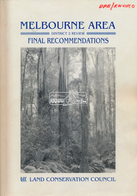 Eltham District Historical Society Inc
Book, Land Conservation Council, Melbourne Area, District 2 Review: Final Recommendations, 1994
Notices showing the boundary of the area of the review and advising that an investigation was to be carried out were published in the Victoria Government Gazette and in local and other Victorian newspapers in May 1987. A descriptive resources report was published in August 1991. Council received 1,425 submissions and letters following publication of the descriptive report. The Council considered these submissions and published proposed recommendations in April 1993. A further 1,993 submissions were received in response to the proposed recommendations. The Council published its final recommendations in July 1994. A change to legislation in 1989 enabled the LCC to make recommendations for public land within a ‘town’, though cities and rural cities remained excluded from the definition of public land. Timber resources and water quality and yield from timbered catchment areas remained significant issues in Melbourne’s catchments. Recommendations for the Yarra Ranges National Park were based around the closed Melbourne water catchments and adjoining state forest. A recommended Phillip Island State Park based around the penguin reserve was ultimately implemented as the Phillip Island Nature Park.Shire of Nillumbik DPE/Enviro -
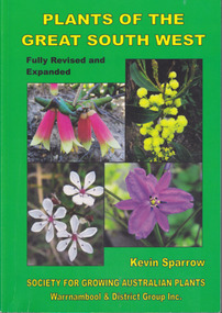 Warrnambool and District Historical Society Inc.
Book, Star Printing Terang Victoria. 978-0-9751360-1-0, Plants of the Great South West 2013 Second Edition, 2013
Second edition (revised a& expanded edition) First edition 2004. Guide to the indigenous plants of South West Victoria. South West Victoria: Nelson – Port Campbell. Zone A.B.C & D. Local maps BioregionsCard cover green) gloss white paper. End papers. Map 1&2. 6 pages credits, title, table of contents, forward, acknowledgements, disclaimer, websites. 348 pages. Colour maps & photographs. References & reading. Index plantsof western victoria, kevin sparrow, warrnambool -
 Federation University Historical Collection
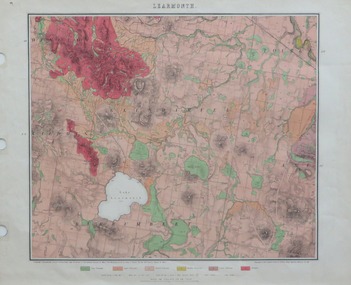
Map, Geological Map of Learmonth, 1882, 10/1882
Two copies: (printed noted attached) 3.) Rectangular geological map edged in masking tape. Six colours define geology and are predominantly pink. Scale 40 chains to one inch .4) Notes referring to the Geological Map of Learmonth learmonth, lake learmonth, glendaruel, burrumbeet, mt blowhard, morton's hill, mt bolan, addington, mt cavern, coghill's hill, mt hollowback, mt pisgah, weatherboard hill, webster's hill, foster's hill, mt bolen, one mile hill, vaughan's hill, tourello stattion, ballarat to maryborough railway, saddleback hill, ceres, brown's hill, ross's hill, norman taylor, robert burrows, richard shephard, james finnie -
 Ringwood and District Historical Society
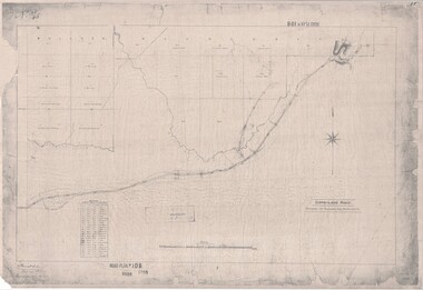
Map, Road Plan 108 - Gipps-land Road, Parishes of Bulleen and Warrandyte (Ringwood, Victoria) - 1855
Surveyor's map of the part of the main road from Melbourne to Gippsland following "Barker's Track" south of Mullum Mullum or Deep Creek. Map references include Roman numerals marking distances measured in Links between trees at turns in the road.Submitted to the Surveyor General (Signed) July 2nd 1855. -
Bendigo Historical Society Inc.
Map - RAVENSWOOD : COUNTY OF BENDIGO, 28-7-14
Map. Ravenswood, County of Bendigo, County of Talbot, Lockwood, Sutton Grange, Harcourt, Walmer, Bradford, Shelbourne, Mandurang, Photo-Lithographed at the Department of Lands and Survey by T.F. McGauran 28-7-14. (number 86 in map cupboard 1)T.F. McGauranmap, bendigo, ravenswood -
Bendigo Historical Society Inc.
Map - CAMPBELL COLLECTION: BENDIGO AND DISTRICT MAPS, 16-4-29
Map. Kennington, Parishes of Sandhurst, Mandurang and Strathfieldsaye. Scale 20 chains to 1 inch. Total area 2918 acres. Prepared in W.P.B. from A. and C.L. Plans by W.J.Galbraith, 16-4-29. (number 394 in map cupboard 1)W.J.Galbraithmap, bendigo, allotments -
Bendigo Historical Society Inc.
Map - CAMPBELL COLLECTION: BENDIGO & DISTRICT MAPS, 22-3 29
Map. Marong, Parishes of Marong, Lockwood and Mandurang. Scale 20 chains to an inch. Total area 5106 acres. Crusoe Reservoir on right. Compiled in W.P.B. from Field Survey and Parish Plans (number 373 in map cupboard 1)G.W.Lmap, bendigo, allotments -
Bendigo Historical Society Inc.
Book - BLUE GUIDE 1988, 1988
Blue Guide 1988 - booklet of Bendigo information with illustrations and map. Includes emergency contaacts, bus and rail timetables, telephone directory, services listing, Justices of the Peace. Booklet sent 'To the Householder' 56 pages plus loose map of BendigoBlue guide publicationsbendigo, hospital, bendigo, information booklet, blue guide. -
 Bendigo Historical Society Inc.
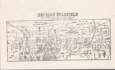
Map - BENDIGO GOLDFIELD MAP
Two not very clear copies of the Bendigo Goldfield Map. Streets, Railway Line, Lines of Reefs and mines are shown. Dept. of Mines, Victoria printed on the map. Shows reefs from Bird's Line of Reefs to Lightning Hill Line of Reef.map, bendigo, goldfields, bendigo goldfield map, lines of reefs, dept. of mines victoria -
Bendigo Historical Society Inc.
Map - ROCHESTER WEST : COUNTY OF BENDIGO, 30-10-12
Map. Rochester West, County of Bendigo, Ballendella, Giggorra, Township of Rochester. Campaspe River. Photo-lithographed at the Department of Lands and Survey, Melbourne, by W.J. Butson 30-10-12. Price 1/-. (number 22 in map cupboard 1)W.J. Butson, Government Printer.map, bendigo, rochester west -
Bendigo Historical Society Inc.
Map - CAMPBELL COLLECTION: BENDIGO AND DISTRICT MAPS, 6-4-28
Map. Sedgwick, Parishes of Strathfieldsaye, Lyell, and Sedgwick. Scale 20 chains to 1 inch. Total area 5372 acres. Prepared in W.P.B. from C.L.and A. Plans by W.J.Galbraith 6-4-28. (number 400 in map cupboard 1)W.J.Galbraith.map, bendigo, agricultural lands -
Bendigo Historical Society Inc.
Map - YALLOOK : COUNTY OF BENDIGO, 1957
Map. Yallook, County of Bendigo,Talambe, Tandarra, Neilborough, Yarraberb, Salisbury, Pompapiel. Drawn and reproduced at the Department of Lands and Survey, Melbourne.1957. Price 2/-. By authority W.M. Houston, Government Printer. (number 11 in map cupboard 1)W.M Houston, Government Printermap, bendigo, yallook -
 Bendigo Historical Society Inc.
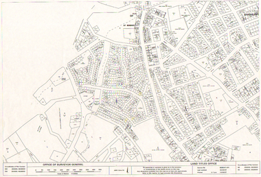
Map - LONG GULLY HISTORY GROUP COLLECTION: LONG GULLY AREA
Copy of a map showing streets and allotments in the Long Gully area, last updated 30/05/97, printed 19/06/97. Made by the Land Titles Office. Some street names, reserves and allotment numbers are printed on the map.bendigo, history, long gully history group, the long gully history group - long gully area, land titles office, office of surveyor general, city of bendigo, shire of marong, state electricity commission -
Bendigo Historical Society Inc.
Map - VICTORIA HILL AREA, May 1971
Map: Bendigo Historical Society feature plan. There are 3 of these plans, one is without feature names and one has several places highlighted in pencil. Compiled by AHQ Survey Regiment, CMF Increment ( number 181 in Map Cupboard 1)map, bendigo, mining plan, victoria hill, bendigo historical society -
Bendigo Historical Society Inc.
Map - TOWNSHIP OF LOCKINGTON, 21/09/1915
Map: Township of Lockington, Parish of Bamawm, County of Bendigo. Parish plan.Has a clipping from 'The Riverine Herald' dated 20/11/1915 on the reverse side re. the sale of blocks in Bamawm Township (number 322 in map cupboard 1)map, bendigo, township, lockington, bamawm, the riverine herald