Showing 7726 items
matching shop.
-
 Whitehorse Historical Society Inc.
Article, Rezoning plan riles retailers, 1992
Despite widespread disapproval by traders and residents, Nunawading Council still plans put its draft structure plan for Vermont South Activity Centre on public display.Despite widespread disapproval by traders and residents, Nunawading Council still plans put its draft structure plan for Vermont South Activity Centre on public display. Council owned land on Burwood Highway is earmarked for rezoning to restricted business zone. The draft has designated the area for a mix of office and retail development. it is not intended to duplicate retail services which already exist. Manager of Vermont South Shopping Centre Patricia Wilson says the traders object to any amount of extra retail development.Despite widespread disapproval by traders and residents, Nunawading Council still plans put its draft structure plan for Vermont South Activity Centre on public display.shops, city of nunawading, wilson, patricia, vermont south shopping centre, burwood highway, vermont south, nos 473-493 -
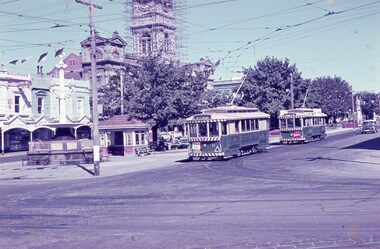 Ballarat Tramway Museum
Slide - 35mm slide/s, Keith Caldwell, 12/03/1962 12:00:00 AM
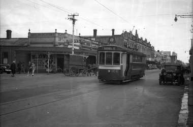
Yields information about the nature of tram services at the city terminus at Sturt and Lydiard St and the street scene at the time.Agfa colour slide, white cardboard mount, photo by Keith Caldwell on 12/3/1962 of: Trams 11 and 27 arriving at the "Tramway Centre" the city terminus. Tram 11 has the destination of Mt Pleasant and has a The Age dash canopy advertisement. No. 27 showing Victoria St and has a Briquettes dash panel advertisement. In the background is the Burke and Wills Fountain, shelter, Golden Star Chinese Cafe, Georges Sea Food shop and the Town Hall with the clock tower having scaffolding around it.In ink "Ballarat 12.3.62"tramways, trams, shelters, sturt st, lydiard st north, fountains, tram 11, tram 27 -
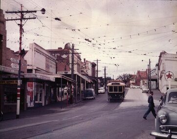
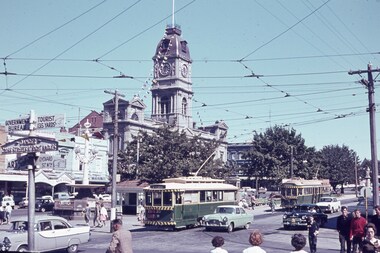 Ballarat Tramway Museum
Slide - 35mm slide/s, Keith Caldwell, 16/03/1963 12:00:00 AM
Yields information about traffic conditions at the intersection of Sturt and Lydiard St and tram operations.Agfa colour slide, white cardboard mount, photo by Keith Caldwell on 16/3/1963 of: Photo of a busy scene at the corner of Sturt and Lydiard Streets. Tram 30 for Mt Pleasant and a Twin Lakes sign is departing the City terminus while No. 36 for Lydiard St North is arriving. The Town Hall and Georges Sea Food shop are in the photo along with a sign on the Post Office steps advising the location of the Government Tourist Bureau, Art Gallery and a cast sign "Danger Cross Street at Right Angles".In ink "16.3.63"tramways, trams, sturt st, lydiard st, city, town hall, tram 30, tram 36 -
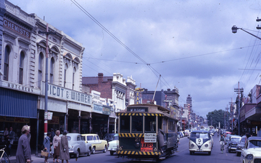 Ballarat Tramway Museum
Slide - 35mm slide/s - set of 2, Noel Simons, 24/11/1962 12:00:00 AM
Set of 2 Kodachrome transparencies taken on 24/11/1962. 1163.1 - No. 21 in Bridge St., with destination of "Mt Pleasant" with a Twin Lakes advert and "Trotting Showgrounds Friday Night" auxiliary board on front dash panel. Also Picot & Widmer, chemists shop alongside tram. Tram at a stop with people boarding. 1163.2 - No. 13 and 30 crossing at the end of the double track in Sturt. St, at Grenville St. Both trams have Twin Lakes signs. Photo shows buildings either side of Sturt St.1163.1 - "No. 21 in Bridge St. Ballarat" 1163.2 - "No. 13 and 30 at foot of Sturt St. Ballarat" All have date stamp of "24 Nov. 1962" in purple ink. All black ink unless otherwise noted.tramways, trams, ballarat, bridge st, grenville st., sturt st., tram 13, tram 21, tram 30 -
 Ballarat Tramway Museum
Negative, Geoff Grant, 19/06/1955 12:00:00 AM
Negative No. N319 and black and white print made by a laser printer (stored in folder ) of W6 988 in Smith St. Fitzroy testing a crossover outside No. 325 Smith St. Has a tower truck in the background. Date of photograph 19/6/1955. Adjacent to tram is A. Brygel drapery shop. Refer to page 414 of Sands and McDougall's Directory of Victoria, 1968 Edition. Negative scanned hi res and imaged updated 21/5/2020. See Refer to page 414 of Sands and McDougall's Directory of Victoria, 1968 Edition.trams, tramways, melbourne, smith st, testing overhead, commissioning, tram w6 988 -
 Ballarat Tramway Museum
Slide - 35mm slide/s, Travis Jeffrey, c1961
Agfa plastic mount (blue base, white cover) with a photo of No. 18 at Gardens Loop, showing Victoria St., note Bell St. auxiliary board, not correct and door opened on wrong side. Posed photograph. Tram is in the process of being fitted with dash canopy lights and tiger strips. Roof advertisements - Whites Florist shop of 2 Sturt St. and Lancashires. Slide rescanned at 3200 dpi 24-10-2020, jpg replaced, tiff file retained. This file was scanned in 2003 and may show colour changes."BAS 9" in penciltramways, trams, gardens loop, wendouree parade, tram 18 -
 Ballarat Tramway Museum
Photograph - Colour Photograph/s, Jim Seletto, c1960
Colour Photograph of SEC tram No. 11, prior to fitting of dash Canopy lighting, c1960, at the intersection of Bridge and Main Streets. Tram No. 11 is arriving from Victoria St. and is about to cross the junction with the Mt. Pleasant line. Trams stops are visible on poles, as is the overhead arrangement, shops on both sides. Tram has large reflective triangles on cab front. Caltex service station sign on right side of photograph. On pole with tram stop sign is a sign with the Olympic rings, pointing way to Lake Wendouree.ballarat, bridge st, victoria st, olympics, tram 11 -
 Ballarat Tramway Museum
Photograph - Black & White Photograph/s, State Electricity Commission of Victoria (SECV), late 1950's or early 1960
Yields information Bridge Street and the buildings at the junction with Main and Victoria St / Stones corner. Tram parked for some particular reason - see 3807.1 to .3 for a similar set of photographs. Shows shops and cars.Black and White photograph, No. 17 at Stone Corner, intersection of Bridge and Main Streets Ballarat. Parked just past the junction points - reason unknown, see also Reg Item 3803, 3807.1 to 3807.3 - for other photographs of the tram at the same location. Photo late 1950's or early 1960. Also has a number of interesting motor vehicles in the background. In the background a Ricksha Paints (pronounced Rickshaw), Allen's Vernal Cake Shop, Junction Shoes. Roddas, ANZ and the English Scottish Bank of Australia buildings in the view. tramways, trams, bridge st, stones corner, tram 17 -
 Ballarat Tramway Museum
Slide - 35mm slide/s, Harry Jackson, Dec. 1971
White cardboard mount, 35mm slide, from the Association of Railway Enthusiast's film strip titled "Provincial Tramway Film Strip" of a Bendigo No. 3 standing at the Eaglehawk terminus with the Town Hall in the background. Tram reflected in shop windows and shows some of the verandas of High St. Eaglehawk. The film strip notes (Reg. Item 2560), provided the following caption details: "Bogie car No. 3 stands at "EAGLEHAWK" in the hot midday sun. = Dec. '71 (Harry Jackson) See image btm2597p.tif for high level scan of image. Stamped on base of slide "11807" and written in ink on top edge "No. 3 Eaglehawk"tramways, trams, are, film strip, high st, eaglehawk, tram 3 -
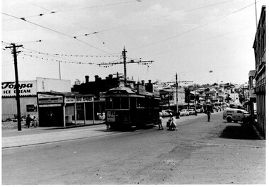 Ballarat Tramway Museum
Photograph - Black & White, Bendigo 3 climbing Mitchell St, late 1950's
Black and White photograph, of Bendigo 3 climbing Mitchell St, near the Railway Station with the Destination of Quarry Hill. Has a Hutton's Ham ad on the front drivers panel and two rood ads. In the background are Sandhurst Dairies shop advertising Toppa Ice Cream, a boot repairer and a van marked Jeffreys Bread parked on the north side of Mitchell St. Nearing the point where the double track became single - see the signal wire insulators in the overhead. Printed on Fujichrome paper. Two copies held."TMSV Sales" stamp on rear. On rear of in ink 'HTT16 = MM N 102 = Geel 32 = BED 3"trams, tramways, bendigo, mitchell st, quarry hill, overhead, tram 3 -
 Ballarat Tramway Museum
Photograph - Digital image, 15/10/1940 12:00:00 AM
Yields information about the Macarthur and Drummond Sts intersection during 1940 and the trams in used and the welding truck.Digital image from the Wal Jack Ballarat Album of a photograph of No. 12 turning from Macarthur St into Drummond St north. Has a shop advertising Preservene Soap in the background and the old welding truck with a warning sign on the back at the rear of the tram. Shows the houses in Drummond St North prior the trees growing. Photo taken 15-10-1940. See image i2 for rear of photograph. See image i3 for hi res scan of print. See image i4 for hi res scan of negativeOn rear of photograph in ink "Ballarat No. 12 turning out of Macarthur St in Drummond St 15-10-40. Note old "Beam" welding unit.trams, tramways, macarthur st, drummond st nth, welding, tram 12 -
 Bendigo Historical Society Inc.
Document - COCKS FAMILY HISTORY
Forty four pages of the Cocks Family History including Acknowledgements and an introductory letter from David James Cocks. No page seven. The Cock Family came England and on arrival in Victoria the letter 's' was added to their surname. Robinson Cock came to Australia at the request of his brother-in-law, John Hunter Patterson, who owned Moorabbee Station, where he started to work. It also tells of the properties owned, horses they bred, dairy farms and later shops in Melbourne which various family members had.person, family, cocks family, cocks family history, david james cocks, robinson cocks, john hunter patterson, bendiog library, mary ann cocks (nee reeves), gwendolyn nellie pegg (nee cocks), herbert james robinson cocks (jim), leslie vincent kennett cocks (les), victor hugh cocks (hugh), herbert victor thomas cocks (bert), nellie cocks (nee mills), leslie robinson cocks, catherine cnatrill (nee cocks), herbert arthur cocks, eve ellen cocks (nee scott), leonard gibb cocks (len), raymond cocks, ingrid cocks (nee petersen), phyllis hope cocks (nee phillips), 'kimbolton', 'mcivor', john ormond randell, latrobe library, melbourne university archives, queensberry hill press, brown prior anderson p/ltd, john cock, katherine robinson, john cock, catherine shepperson -
 Bendigo Historical Society Inc.
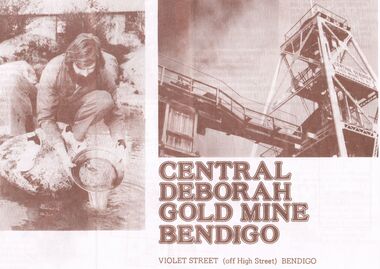
Document - JOAN O'SHEA COLLECTION: CENTRAL DEBORAH GOLD MINE BENDIGO, 26th November, 1984
Joan O'Shea Collection. Central Deborah Gold Mine Bendigo. Promotional material. Chronological History, Poppet legs and shaft, Change Room, Caretakers or rag pickers room, Drying room, first aid room, carbide light room, Underground, carpenters shed, ore bins and loading bays, stamper battery, wilfley table, berdan pans, laboratory, display room, boiler, stroke hold, winding engine, boiler feed pump, electric driven compressor, steam driven compressor, blacksmith's shop.Photograph Courtesy Philip Beer.mining, marketing, central deborah mine. -
 Bendigo Historical Society Inc.
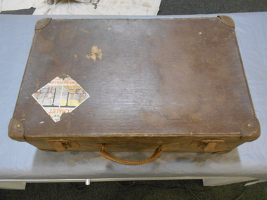
Functional object - Suitcase Made in Bendigo
G. Harper was a saddler and harness maker located at Bath Corner, Charring Cross. He advertised in The Bendigo Advertiser in 1892A brown suitcase with two metal clasps which could be locked. There are two travel stickers, ones a Victorian railways luggage Melbourne Albury which is partly missing, the other is The CHALET MT BUFFALO Nation Park. On the inside of the lid there are two labels one is black with gold letters G. HARPER NEW BAG SHOP Leather Goods & Ladies' Hand Bags Travelling Bags & Trunks Saddler & Harness Maker Charing Cross BENDIGO The other is light blue with black writing, QUALITY Guaranteed M.B. Fibre CASE.182 underlined made in bendigo, suitcase, g. harper saddler and harness maker -
 Kew Historical Society Inc
Photograph, Stuart Tompkins Studio, Electricity Supply Poles, Warrigal Road, Ashwood, 1965
Research provided by Stuart Tompkins Studio, Box Hill, into alternatives for median strip street lighting to be used in Burke Road, Kew. The photographers identified variants in different suburbs appropriate to Kew's needs.The series from which the photograph is drawn provides a snapshot by a commercial photographic studio of each named vicinity in 1965 as well as providing examples of public works infrastructure being commissioned by local government in the 1960s. The photos originally formed part of the Engineering Department's files in the City of Kew before being donated to the kew Historical Society.Electricity Supply Poles, Warrigal Road, Ashwood, 1965. Stuart Tompkins Studio provided this photograph for the Kew City Council. The photograph, taken at the intersection of Warrigal Road and High Street South, Ashwood looks north along High Street Road. The intent of the photograph was to provide the Council with models of electricity supply poles. In the photo, wooden and steel poles can be seen in the median strip. The photograph also includes the shops bordering High Street Road during this period. [There are three copies of this photograph in the Collection.]. Typed inscription on reverse: "Electricity Supply Poles. Photographed for Kew City Council 8/2/65. No.4 Warrigal Road - Ashwood. South of High Street Road looking north. Wooden and steel poles with different brackets in median strip." Studio stamp: "Stuart Tompkins Studio. 547 Station Street, Box Hill. WX1439."electric light poles, public works -- 1960s, civic infrastructure -- 1960s -
 Kew Historical Society Inc
Photograph, Stuart Tompkins Studio, Electricity Supply Poles, Warrigal Road, Ashwood, 1965
Research provided by Stuart Tompkins Studio, Box Hill, into alternatives for median strip street lighting to be used in Burke Road, Kew. The photographers identified variants in different suburbs appropriate to Kew's needs.The series from which the photograph is drawn provides a snapshot by a commercial photographic studio of each named vicinity in 1965 as well as providing examples of public works infrastructure being commissioned by local government in the 1960s. The photos originally formed part of the Engineering Department's files in the City of Kew before being donated to the kew Historical Society.Electricity Supply Poles, Warrigal Road, Ashwood, 1965. Stuart Tompkins Studio provided this photograph for the Kew City Council. The photograph, taken at the intersection of Warrigal Road and High Street South, Ashwood looks north along High Street Road. The intent of the photograph was to provide the Council with models of electricity supply poles. In the photo, wooden and steel poles can be seen in the median strip. The photograph also includes the shops bordering High Street Road during this period. [There are three copies of this photograph in the Collection.]. Typed inscription on reverse: "Electricity Supply Poles. Photographed for Kew City Council 8/2/65. No.4 Warrigal Road - Ashwood. South of High Street Road looking north. Wooden and steel poles with different brackets in median strip." Studio stamp: "Stuart Tompkins Studio. 547 Station Street, Box Hill. WX1439."electric light poles, civic infrastructure - 1960s, public works -- 1960s -
 Kew Historical Society Inc
Photograph, Stuart Tompkins Studio, Electricity Supply Poles, Warrigal Road, Ashwood, 1965
Research provided by Stuart Tompkins Studio, Box Hill, into alternatives for median strip street lighting to be used in Burke Road, Kew. The photographers identified variants in different suburbs appropriate to Kew's needs.The series from which the photograph is drawn provides a snapshot by a commercial photographic studio of each named vicinity in 1965 as well as providing examples of public works infrastructure being commissioned by local government in the 1960s. The photos originally formed part of the Engineering Department's files in the City of Kew before being donated to the kew Historical Society.Electricity Supply Poles, Warrigal Road, Ashwood, 1965. Stuart Tompkins Studio provided this photograph for the Kew City Council. The photograph, taken at the intersection of Warrigal Road and High Street South, Ashwood looks north along High Street Road. The intent of the photograph was to provide the Council with models of electricity supply poles. In the photo, wooden and steel poles can be seen in the median strip. The photograph also includes the shops bordering High Street Road during this period. [There are three copies of this photograph in the Collection.]. Typed inscription on reverse: "Electricity Supply Poles. Photographed for Kew City Council 8/2/65. No.4 Warrigal Road - Ashwood. South of High Street Road looking north. Wooden and steel poles with different brackets in median strip." Studio stamp: "Stuart Tompkins Studio. 547 Station Street, Box Hill. WX1439."electric light poles, public infrastructure -- 1960s, civic works -- 1960s -
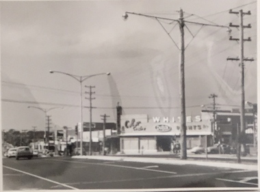
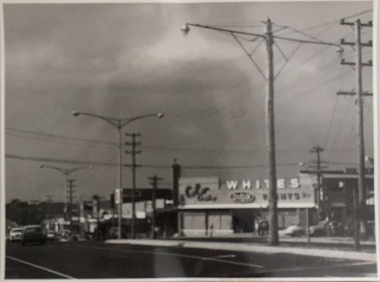
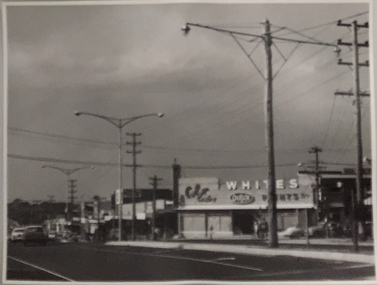
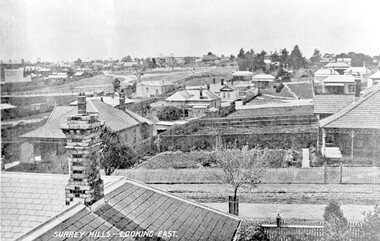 Surrey Hills Historical Society Collection
Photograph, Surrey Hills - Looking East from Essex Road, circa 1900, c1900
Date is approximate. Two original post cards of this image - "Surrey Hills - looking East" - were donated by Stephen Wyatt on 10 March 2012. One is blank; the other has been sent to Mrs A Wyatt, C/O Mrs E Young, 'Grand View', Warburton from daughter Nellie from 'The Quantocks', Surrey Hills - postmarked 10 Dec 1906. There is also a reproduction of this image in a framed collage of Surrey Hills photos.This is the earliest known image of the Surrey Gardens. The layout was originally designed by William Guilfoyle, who also designed Melbourne’s Royal Botanic Gardens.Black and white photo taken from an early postcard. Taken from the roof of a house in Essex Road, it shows the development of housing between Essex and Union Roads and includes the section of land fenced off for the Surrey Gardens with paths roughly laid out, one existing tree but no tree planting. The houses depicted are largely Edwardian timber buildings with corrugated rooves. There are still some vacant blocks. Kirkland on Union Road can be seen in the distance, as can some of the shops along Canterbury Road.Lower LHS within original image: " Surrey Hills - Looking East"; on the rear "No 17" in black pen in top LH corner.edwardian style, residential development, kirkland, essex road, suffolk road, norfolk road, surrey gardens, post card -
 Surrey Hills Historical Society Collection
Photograph, Mr Wally Ives delivery truck decorated for Empire Day, 1937, 1937
Frank Leslie Barkla was a keen amateur photographer and member of the Melbourne Camera Club. This is an almost identical shot to SH0379, however this is a better print with greater contrast.Black and white photo of a decorated vehicle owned by Mr Wally Ives outside his fruit and vegetable shop at 154 Union Road, Surrey Hills on occasion of Empire Day celebrations in 1937. The truck is decorated with the foliage of palm trees, ribbons, strings of round balls, which are also arranged in coronets, pumpkins and strings of carrots and Union Jack flags. The wheels of the vehicle are decorated with flowers. Wally Ives' name is on the side of the truck; THE EMPIRE is written on the door of the truck and in balls attached to its side.transport, empire day, parades and processions, wally ives, frank leslie barkla, greengrocers, fruiterer -
 Ringwood and District Historical Society
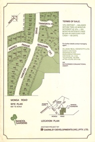
Flyer, Land Sale Advertisement - Banool Gardens Subdivision, Ringwood, Vic. c.1985
Double-sided advertisement for Banool Gardens subdivision with site plan, location plan, terms of sale, and summary of homesite features and local services & facilities. Subdivision includes Wonga Road, Hamilton Drive, Tinworth Place, Andrea Parade and Benjamin Court, Ringwood North. Managing agent - Ollson Real Estate Pty. Ltd., North Croydon Shopping Plaza, Maroondah Highway. Croydon, Vic. 3136. Telephone 726 9988 After Hours 876 4190. Project by Darnley Developments (Vic.) Pty. Ltd. Accompanying handwritten notation by Richard Carter R.E.S.I. - "Part of original Banool property (Mahon, sold to Stallman, sold to McMahon, sold to Len Macley etc etc). Hamilton Drive named after Lynn Hamilton McMahon, Tinworth Place after his son-in-law, David Tinworth". -
 Lakes Entrance Historical Society
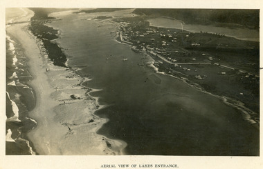
Photograph - Lakes Entrance, 1923c
Two copies 16.5 x 25.5 very darkBlack and white photograph showing early aerial view of township of Lakes Entrance, photo shows highway going along Myer Street and along Roadknight Street, no shops in Myer Street appears to be no foot bridge, therefore taken prior to 1937, sparce vegetation on foreground dunes, four barriers built on dunes to stop erosion through sand, two masted sailing boat in lake. Bullock Island in distance appears very small, Snake Island of Rigby Island in centre distance. Lakes Entrance VictoriaAerial View of Lakes Entrancewaterways, coast, aerial photograph, islands, township -
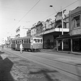
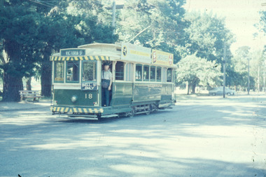
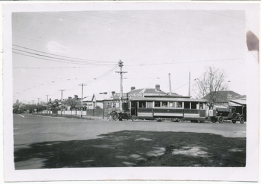
 Ballarat Tramway Museum
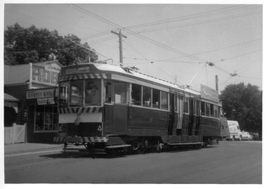
Photograph - Black & White Photograph/s, Bob Lilburn, 17/01/1969 12:00:00 AM
Black and white photograph of Ballarat tram No. 37 at the Mt Pleasant terminus. Tram has destination of "Gardens via Drummond Nth.", roof advertisement for the SEC "Everything's under control in my all electric kitchen". Shop on the left hand side of the photo has Robur Tea company, Coca Cola and Women's Weekly advertisements. High Res image added 8/5/2019 from Peter Lambert. 2nd print - dates the photo as 17-1-1969 a photo by Bob Lilburn.On rear of 2nd image - "2nd Ballarat 37, Mt Pleasant, Ex Bendigo 1, Ex Geelong 35" and "ex MMTB 119, 17-1-69"trams, tramways, mt pleasant, barkly st, tram 37 -
 Melbourne Tram Museum
Letter, Australian Electric Traction Association (AETA), "Transporting Melbourne", 4/12/1996 12:00:00 AM
Letter - 8 A4 pages stapled in top left hand corner - AETA to "Transporting Melbourne", Ministry of Transport, dated 4-12-1996 forward comments or making a submission regarding the proposed framework. Endorse the concept, backlog in Melbourne public transport, railway electrification, tramway and light rail extensions; East Malvern Station, Box Hill, Station Pier, Westfield Shopping centre, Highpoint West, South bank Route and other suggestions made regarding re-routing of trams services.trams, tramways, aeta, submissions, new tramway, melbourne, public transport, box hill -
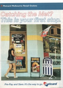 Melbourne Tram Museum
Pamphlet, VicTrip, "Catching the Met? - This is your first stop.", Apr. 1999
Pamphlet - four fold - special size - full colour titled "Catching the Met? - This is your first stop." giving the list of Metcard shops in central and suburban Melbourne, along with maps of the tram and train systems. The maps show both Yarra and Swanston trams with route numbers along with Bayside and Hillside trains and the various ticket zones at the time. The number of car parking spots at each station also shown. On the rear is general information about Metcard with ticket machines, and validators. List dated effective from April 1999.trams, tramways, maps, metcard, yarra trams, swanston trams, hillside trains, bayside trains, tickets -
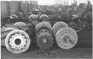 Melbourne Tram Museum
Photograph - Set of 7 Black & White Photograph/s, Melbourne & Metropolitan Tramways Board (MMTB), c1979 - 1970
Series of seven black and white photographs of Resilient wheels at the Preston Workshops. .1 - General view of the truck shop showing wheels completed and partially dismantled. .2 - showing a complete wheel axle with gear. (not imaged) .3 - showing a complete wheel and journal .4 - showing the various components set out. .5 - "Manufacture of one of jigs for new resilient wheels - MMTB design No. 2" .6 - detail of the one of the outer components. .7 - detail of another component that appears to have been damaged.trams, tramways, preston workshops, wheels, resilient wheels, testing, trucks -
 Melbourne Tram Museum
Negative, Wal Jack, c1943-44
Black and white negative, by Wal Jack, of S class 166 (showing Russell St), in Barkly St Footscray. Based on the photograph, the tram is inbound to Footscray Station, as the buildings match the current (12/2020) Google Earth view at 185 Barkly St and Albert St. In the background is - Brown's Dry cleaner, a Millinery shop at 185, W. Adler Tailor, J. Paarons PA (Radio) on the clockface and H E M Burrow? store sign. A horse drawn van is alongside the tram. Photo undated, c1943-44trams, tramways, barkly st, footscray, russell st, s class, tram 166, mmtb -
 Melbourne Tram Museum
Negative, Wal Jack, 25/06/1955 12:00:00 AM
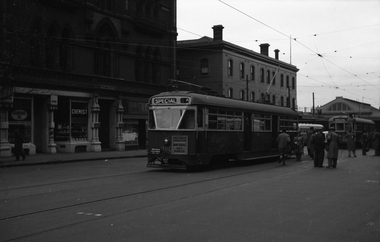
Black and white negative, by Wal Jack, of PCC 980 on the AETA tour of 25/6/1955 at Spencer St terminus in Bourke St. Behind the tram is the second tour car W7 1001. The tram has an AETA Special car sign and a "Solve Traffic Congestion Move People not vehicles". In the background is Carlyon's Hotel, Spencer St Station and the MMTB / MTOC head office building. Also visible is a single deck bus. Also a Chemist selling Kodak film and a shop selling Craven A cigarettes.trams, tramways, bourke st, opening, aeta, buses, tram 980, mmtb, pcc class, tram 1001, w7 class, mtoco building -
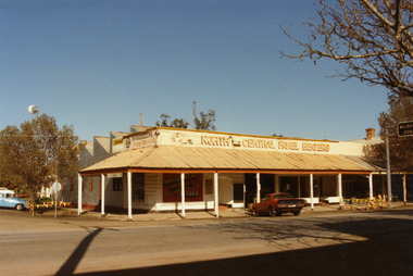 Charlton Golden Grains Museum Inc
Photograph, North Central Panel Beaters 1987, c.1987
North Central Panel Beaters 1987, formerly Charlton Motors Pty Ltd Service StationColour photograph showing North Central Panel Beaters building on the corner of High and Armstrong Sts. Red car in front of shop on High St, blue & white vehicle on LH side on Armstrong St. Sign attached to verandah showing St Arnaud 42. Signage on front window says Mechanical Repairs, Automotive Service Centre, Ph S?. 1389. Safety tape around tree on LH side of photo and barricades on the High St kerb at the end of the verandah. Telstra tower visible in background.north central panel beaters, charlton motors, business, industry, armstrong street, charlton -
 Bendigo Historical Society Inc.
Document - VICTORIA HILL - VICTORIA HILL HISTORY
Hand written notes and typed copy of the history of Victoria Hill area. Some of the mines from South to North: North Old Chum, Lansell's 'Big 180', Ballerstedt's Open - Cut, 20 Head Battery Stampers, The Victoria Quartz, Rae's Open - Cut, which has some colourful geographical features, Central Victoria (also known as the 'Midway'), Wittshiebe's 'Jeweller's Shop', Boldt's 5 Head Crushing Battery (site only), Advance Shaft, Hercules & Energetic. Notes prepared by Albert Richardson.mine, gold, victoria hill, victoria hill, victoria hill history, north old chum, john wybrandt, lansell's 'bit 180', t ballerstedt, wittschiebe, fortuna villa, geo lansell, a h q survey regiment, ballerstedt's open cut, victoria quartz (victoria reef quartz), rae's open cut, wm rae, gt central victoria (midway), adventure, wittshiebe's 'jeweller's shop', boldt's 5 head crushing battery, advance, cinderella, hercules & energetic, john brown knitwear factory, a richardson -
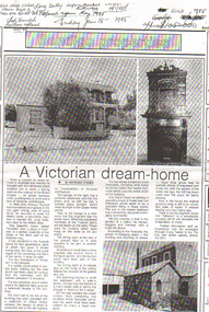 Bendigo Historical Society Inc.
Document - LONG GULLY HISTORY GROUP COLLECTION: A VICTORIAN DREAM HOME
Anthony Truscott ( 1856-1913) was a Cornishman who came to Bendigo in 1880. He initially undertook mining interests before opening a grocery store in 1884. The house at 2 Havilah STreet, "Kilhallen", was probably named after his hometown in Cornwall.Real Estate advertisement for a home built by Anthony Truscott in 1900 called Kilhallen. There are three photos, one of the two story house, one of the ornate fireplace and a small add on building at the rear. Written at the top of the page is: Old shop pulled down and a new one Built Feb 90. Long Gully Super Market closed riteway 14/1/85. opened again May 1985. Sold 1985. approx $105 000 Which is crossed out. Friday Jan 18 - 1985.bendigo, history, long gully history group, the long gully history group - a victorian dream home, richard foord, bendigo advertiser, anthony truscott, kilhallen, craig tweed & co