Showing 4549 items matching "historical maps"
-
 Victorian Railway History Library
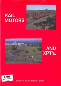
Book, Cooke, David, Rail Motors and XPT's, 1984
A history of rail motors and the XPT passenger train in New South Wales.ill, maps, p.142.non-fictionA history of rail motors and the XPT passenger train in New South Wales.railroads - passenger trains - australia, rail motors - new south wales - history -
 Victorian Railway History Library
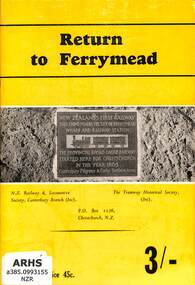
Booklet, N.Z. Railway & Locomotive Society, Canterbury Branch : Tramway Historical Society, Return to Ferrymead, 1966
A history of the railways of Ferrymead - the site of the first steam operated railway in New ZealandIll, maps, p.28.non-fictionA history of the railways of Ferrymead - the site of the first steam operated railway in New Zealandhistory of railways - new zealand, railways - ferrymead -
 Victorian Railway History Library
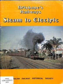
Book, Australian Railway Historical Society - Queensland Division, Brisbane's Railways: Steam to Electric, 1979
A history of the conversion of the Brisbane suburban railways from steam and diesel to electric operations. Produced to commemorate the inauguration of electric rail services in Brisbane.ill, maps, p.50.non-fictionA history of the conversion of the Brisbane suburban railways from steam and diesel to electric operations. Produced to commemorate the inauguration of electric rail services in Brisbane.railroad operations - queensland - history, electric trains - brisbane - history -
 Victorian Railway History Library
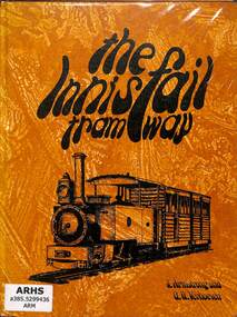
Book, Armstrong, John et al, 1973
The story of the history and development of the Geraldton Shire Tramway and the Mourilyan Tramway of North Queensland.ill, maps, p.103.non-fictionThe story of the history and development of the Geraldton Shire Tramway and the Mourilyan Tramway of North Queensland.railroads - queensland - history, tramways - australia -
 Warrnambool and District Historical Society Inc.
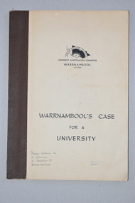
Booklet, Warrnambool's Case for a university, 1961
The information in this booklet was prepared by a University Investigation Committee formed in Warrnambool in 1961 to present the case for the establishment of a university in the Warrnambool area. The chairman of this committee was the Mayor of Warrnambool, Cr P. O’Sullivan and the secretary was W. L. George of Warrnambool. This submission was unsuccessful at the time but campaigning for a university continued. In 1961 Warrnambool Technical School in Timor Street was offering both secondary and tertiary courses in the technical and trades areas and in 1969 the tertiary section of this Technical School became the Warrnambool Institute of Advanced Education. The tertiary section was relocated in 1984 to Sherwood Park, a 94 hectare site on the Princes Highway five kilometres from Warrnambool’s C.B.D. In 1990 Deakin University established a regional campus at Sherwood Park after a merger with the Warrnambool Institute of Advanced Education. This booklet has some historical significance as it contains the information collated on the campaign in Warrnambool and the Western District for a university to be established in the Warrnambool area.This is a soft cover booklet of 48 pages. It has a beige-coloured cover with black printing. The booklet has been bound with brown tape. It has printed information, black and white photographs, a fold-out map, graphs and tables.deakin university, history of warrnambool -
 Bendigo Historical Society Inc.
Book - STRAUCH COLLECTION: THE PENINSULA STORY BOOK 1
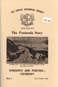
BHS CollectionThe Peninsula Story Book 1 Sorrento and Portsea Yesterday presented by the Nepean Historical Society, 63 pages with black and white photographs & maps.victoria, history, nepean peninsula, victoria-history-nepean peninsula- sorrento - portsea -
 Warrnambool and District Historical Society Inc.
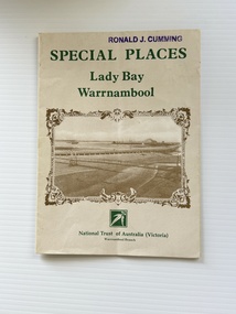
Pamphlet - Special Places Lady Bay Warrnambool, Philprint Warrnambool, 1989
This pamphlet was produced for the Warrnambool Branch of the National Trust of Australia (Victoria) for Heritage Week, April 16-23, 1989 and contains information written by Warrnambool residents about their locality. This was a co-operative venture by people with a common interest in protecting the natural environment near their home. Areas covered in the written information include: Formation of the Coast, Archaeological survey, Gunditjmara History, vegetation, history and recreational uses of the Lady Bay area. The map shows special places of interest including past and present navigational aids, sites of shipwrecks and other historical places of interest. The Warrnambool Branch of the National Trust was originally formed in March 1969 and merged with the Port Fairy Branch in late 1970. In October 1979, the Warrnambool Branch was reformed and operated into the late 1990's. This is an example of a publication produced by the Warrnambool Branch of the National Trust Australia (Victoria). It provides historical information and perspectives of the recreational uses in and around Lady Bay Warrnambool.An A2 piece of buff coloured thick paper folded into eight to make an A5 pamphlet. The front cover has green printing with the National Trust symbol of three eucalyptus leaves in green. There is a brown sepia photograph showing a view across Lady Bay with the suspension bridge across the Merri River in the foreground, Viaduct Road in the middle ground and the breakwater in the background. There is a purple inked stamp on the top right hand corner. The rear cover has brown writing and includes logos of bodies who assisted with the publication. There is a brown line drawing of the viaduct and pier at the Warrnambool Breakwater. The inside of the unfolded pamphlet contains a map of Lady Bay and adjacent area showing places of interest and shipwrecks marked in red circlesFront cover: Special Places Lady Bay Warrnambool National Trust of Australia (Victoria) Warrnambool Branch Ronald J. Cummingwarrnambool, lady bay warrnambool, national trust australia victoria warrnambool branch, heritage week 1989, lady bay shipwrecks -
 Victorian Railway History Library
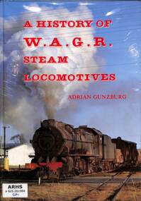
Book, Gunzburg, Adrian, A History of W.A.G.R. Steam Locomotives, 2000
A history of the steam locomotives on the Western Australian Government Railways.index, ill, maps, p.156.non-fiction A history of the steam locomotives on the Western Australian Government Railways.locomotives -- australia -- history, railroad locomotives - western australia - history -
 Eltham District Historical Society Inc
Book, Jenny Brown et al, Out of the Mist; Osborne Peninsula, 2024
The Osborne Peninsula on the Yarra River at Warrandyte accommodates a limited number of properties and residents (70 households). The area is rich in geology and ecology, and an unusually rich endowment of human, built and creative history. Contents: Welcome: The landform: The River: Aboriginal occupation: The Miners: North Warrandyte :The Subdivision: The Lowes: The Osbornes: The Last Osborne: The Elders: The Relics: Dray Track: Water Wheel"Kauri Plaque: River track: Pines: Windmill Creek Bridge: The Koornong School: The Houses" Man Cave: MidCentury Classic: Enduring Original" Masterwork: The Muddies: The State Park: The Saving of Koornong Reserve: The Landcare Story: Flora and Fauna: The Vulnerable, Endangered and threatened: Birds: Mammals: "Waring" the wombat: Reptiles: Fish: Invertebrates: Flora: Fire. Published by the North Warrandyte (Osborne Peninsula) Landcare Group. Includes photos from EDHS collection.64 p. : ill., map ; 29.7 x 21 cm. (2 copies)yarra river, birrarung, dray track, fauna, geology, houses, indigenous history, koornong reserve, koornong school, lowe family, mining, mudbrick houses, north warrandyte, osborne family, warrandyte state park, water wheel, north warrandyte (osborne peninsula) landcare group, osborne peninsula -
 Glen Eira Historical Society
Document - Historic Conservation Areas Project
Contains 4 items relating to historic conservation: 1/Five newsletters (one page each newsletter, dated 07/1975, 08/1975, 09/1975, 10/1975 and the final one 12/1975) describing how the project evolved, project funds, progress, study method, project 1 report, project 2 report and summary as no further funds available. Project was to include all of Melbourne but funding did not allow this. Note: newsletters stamped with Caulfield Historical Society. 2/Letter (one page on official city of Caulfield letterhead) from Andrew Rodda (manager planning) to Hazal Ford (dated 13/11/1989) describing ‘council resolved on 18/07/1989 to proceed with preliminary conservation survey’ and mentions that a copy is included. 3/Preliminary conservation survey for the City of Caulfield (nine pages) describing background, study area, budget, purpose, study outline, timeframe, report format, ownership, tasks and background information (mentions number and types of houses and properties as at 1986 and 1988) and a map of City of Caulfield. 4/Booklet (28 pages) titled ‘Heritage Area – Caulfield North Draft Heritage Guidelines July 1999 – City of Glen Eira’, containing Caulfield North Heritage Area, cultural heritage, Heritage Overlay Area, architectural description, common architectural forms and features, development guidelines, key design checklist. It includes a map of the Caulfield North Heritage Overlay Area, two illustrations about the development envelope and many black-and-white photographs of houses and architectural features.historic conservation areas project niven barbara, newsletters, town planning, historic buildings, heritage studies, housing, royal historical society of victoria (rhsv), read michael, plans, local government, historical societies, committee for urban action (cua), national trust, hopkins sherry ms., ford hazel, preliminary conservation survey, town planning, heritage studies, rodda andrew, city of caulfield, housing estates, victoria national estate grants program, australia icomos, burra charter, buildings structures and establishments, land surveys, suburbs, historic buildings, architectural significance, ‘caulfield’s heritage study’, soloman geulah dr., caulfield library, dandenong road, nepean highway, hotham street, iknerman road, orrong road, north road, poath road, ‘plan of the city of caulfield’, north ward, east ward, south ward, west ward, kooyong road, neerim road, bambra road, balaclava road, shire of caulfield, railways, world war 1914-1918, depression 1929-1939, rippon lea, labassa, parks, mansions, community services, ‘caulfield north draft heritage guidelines july 1999’, city of glen eira, caulfield north heritage area, glen eira heritage management plan, mayfield grove, normanby avenue, carnarvon street, glenferrie street, arthur street, malakoff street, normanby road, heritage advisory service, construction materials, victorian style, mediterranean style, spanish mission style, californian bungalow style, federation style, architectural style, architectural features, heritage conservation design, building construction, building regulations, aboriginal peoples, carnarvon road -
 Surrey Hills Historical Society Collection
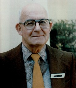
Photograph, Alan Holt
Alan Holt was keenly interested in the history of Surrey Hills. He worked in the Lands Department and drew up maps of the area based on research he conducted there in his spare time and after retirement. He also compiled a survey of owners / occupants of all Surrey Hills listings from Sands & MacDougall directories at 10 year intervals. These are meticulously entered into hand-written ledgers. All his work is also entered on to index cards. With a lifetime's knowledge of local history and research techniques, Alan found himself after retirement, in constant demand as an amateur historian working for the Box Hill Historical Society and the History Group of the Surrey Hills Neighbourhood Centre. When the Surrey Hills Historical Society was formed, Alan and Edna became its first and only Life Members. Alan began work in the Department of Crown Lands and Survey. In the 1950s-60s he moved to the Premier's Department where he assisted with the planning for the Queen's 1954 visit. He was promoted to Permanent Head of the Lands Department until retirement in 1972. He was associated with the Surrey Hills Uniting Church all his life. There is a copy of this photo in a brass frame.A colour portrait photo of the late Alan Holt.alan holt -
 Bacchus Marsh & District Historical Society
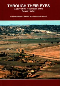
Book, Through Their Eyes : A Story of the Reclamation of the Rowsley Valley
This book contains a collection of articles written by landholders, local residents and members of corporate and volunteer organisations describing their roles in the restoration of Rowsley Valley. The historical scope of this book encompasses the geological and environmental history of the area prior to human habitation, occupation by the Wadawurrung people prior to European colonisation, and the colonial and post colonial eras. This introductory contextual background is complemented by the rest of the book which describes the various aspects of the environmental restoration of the Rowsley Valley from the latter part of the 20th century continuing to the present day.Printed foolscap size book. Softcover. 112 pages. Colour and black and white photos. Maps, figures, tables. Index. Publication details. Graham Simpson (Publisher, Bacchus Marsh, Victoria, 2021. Lead authors Graham Simpson, Jeanette McGonegal and Alan Morton.This book contains a collection of articles written by landholders, local residents and members of corporate and volunteer organisations describing their roles in the restoration of Rowsley Valley. The historical scope of this book encompasses the geological and environmental history of the area prior to human habitation, occupation by the Wadawurrung people prior to European colonisation, and the colonial and post colonial eras. This introductory contextual background is complemented by the rest of the book which describes the various aspects of the environmental restoration of the Rowsley Valley from the latter part of the 20th century continuing to the present day.environmental restoration projects, rowsley valley victoria environmental history, conservation of natural resources, aboriginal australians bacchus marsh region history, wadawurrung people history -
 Greensborough Historical Society
Newsletter, Greenhills and North Greensborough Progress Association, Community News: official journal of the Greenhills and Nth. Greensborough Progress Association.1st October, 1974. Edition No. 6/74, 01/10/1974
This edition includes articles on Rotaract, Farewell to Harry Nash, From the Council Chamber, Yandell Reserve weed-in, New Hall design, Kinder news, Results of Street poll, Meet the natives, Natural history for young and old [Field Naturalists' Club], Open Forum. A digital copy of this Newsletter is available from Greensborough Historical Society.Newsletter, 24 p., illus., mapgreenhills and north greensborough progress association, greenhills -
 Greensborough Historical Society
Newsletter, Greenhills and North Greensborough Progress Association, Community News: official journal of the Greenhills and Nth. Greensborough Progress Association and the Apollo Parkways Progress Association.13th December, 1976. Edition No. 11/76, 13/12/1976
This edition includes a report on the The Apollo Parkways Progress Association's November 1976 meeting, Goodbye to old Greensborough?, Lament for the loss of my loved one - Greensborough, Is bigger best?, Church of Christ, This and That, A breeding success story, Cameo of Eric and Prisca Rosario, Land of the brave & the free, Grief, Nursing Mothers Association, Parent Australia, From the Council Chamber, School news, Scout news, Plenty Valley Squash Club, Bird survey of Yandell Reserve. A digital copy of this Newsletter is available from Greensborough Historical Society. Newsletter, 24 p., illus., map.greenhills and north greensborough progress association, greenhills, apollo parkways progress association, apollo parkways -
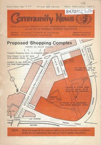 Greensborough Historical Society
Newsletter, Greenhills and North Greensborough Progress Association, Community News: official journal of the Greenhills and Nth. Greensborough Progress Association and the Apollo Parkways Progress Association.10th February, 1977. Edition No. 1/77, 10/02/1977
Proposed shopping complex - Public meeting, Super shops, Letters to the Editor, From the Council Chamber, Freedom from despair, Grow, Co-operative education in Diamond Creek, This and that,. Supplement to "Community News". No. 1/77. Geoff Kerry has a... Community News "family chat". A digital copy of this Newsletter is available from Greensborough Historical Society. Newsletter, 20 p., illus., map.greenhills and north greensborough progress association, greenhills, apollo parkways progress association, apollo parkways -
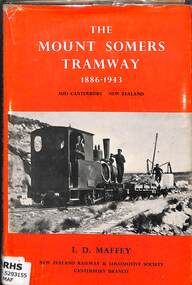 Victorian Railway History Library
Book, Maffey, I.D, The Mount Somers Tramway 1886-1943, 1971
A history of the Mount Somers Tramway in the mid-Canterbury region of the South Island of New Zealand.index, ill, maps, p.113.non-fictionA history of the Mount Somers Tramway in the mid-Canterbury region of the South Island of New Zealand.railroad construction - new zealand, railroad operations - new zealand -
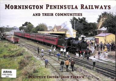 Victorian Railway History Library
Book, Patrick, Joan, Mornington Peninsula Railway and their communities, 2004
A history of the Mornington Peninsula Railways in Victoria, including to Mornington, Red Hill & Stony Point.ill, maps, p.74.non-fictionA history of the Mornington Peninsula Railways in Victoria, including to Mornington, Red Hill & Stony Point.railroad construction - victoria - history, mornington peninsula - railways - history -
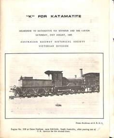 Victorian Railway History Library
Booklet, Australian Railway Historical Society (Victorian Division), K For Katamatite, 1965
Tour notes for a train trip to Katamatite branch line from Shepparton in Victoria. A trip run by the Australian Railway Historical Society Victorian Division on Saturday 21th August 1965ill, maps, p.8.non-fictionTour notes for a train trip to Katamatite branch line from Shepparton in Victoria. A trip run by the Australian Railway Historical Society Victorian Division on Saturday 21th August 1965railroad construction - victoria - history, katamatite tramway - railway - history -
 Victorian Railway History Library
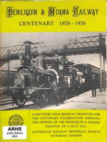
Booklet, Turton, Keith et al, Deniliquin and Moama Railway Centenary 1876-1976, 1972
A brief history of the Maryborough to Avoca and Ararat railway in Victoria as part of Tour notes for a train trip run by the Australian Railway Historical Society Victorian Division on Saturday 11th November 1972.ill, maps, p14.non-fictionA brief history of the Maryborough to Avoca and Ararat railway in Victoria as part of Tour notes for a train trip run by the Australian Railway Historical Society Victorian Division on Saturday 11th November 1972.railroad construction - victoria - history, maryborough to ararat railway - history -
 Victorian Railway History Library
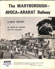
Booklet, Turton, Keith et al, The Maryborough-Avoca-Ararat Railway: A Brief History, 1972
A brief history of the Maryborough to Avoca and Ararat railway in Victoria as part of Tour notes for a train trip run by the Australian Railway Historical Society Victorian Division on Saturday 11th November 1972.ill, maps, p16.non-fictionA brief history of the Maryborough to Avoca and Ararat railway in Victoria as part of Tour notes for a train trip run by the Australian Railway Historical Society Victorian Division on Saturday 11th November 1972.railroad construction - victoria - history, maryborough to ararat railway - history -
 Victorian Railway History Library
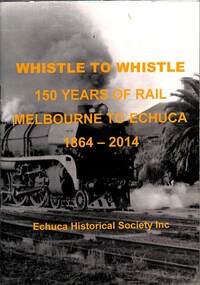
Book, Echuca Historical Society Inc, Whistle to Whistle 150 Years of Rail Melbourne to Echuca 1864-2014, 2014
A brief history of the Melbourne to Echuca railway in Victoria from 1864 to 2014 to commemorate 150 years since the opening of the railway.ill, maps, p.33.non-fictionA brief history of the Melbourne to Echuca railway in Victoria from 1864 to 2014 to commemorate 150 years since the opening of the railway.railroad construction - victoria - history, railways - echuca - history -
 Victorian Railway History Library
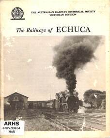
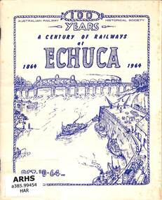
Book, Harvey, James Young, The Railways of Echuca, 1964
A reprint of 'A Century of Railways at Echuca' with a brief history of the Melbourne to Echuca railway in Victoria from 1864 to 1964 to commemorate the centenary of the railway opening.ill, maps, p.39.non-fictionA reprint of 'A Century of Railways at Echuca' with a brief history of the Melbourne to Echuca railway in Victoria from 1864 to 1964 to commemorate the centenary of the railway opening.railroad construction - victoria - history, railways - echuca - history -
 Victorian Railway History Library
Book, Harvey, James Young, A Century of Railways at Echuca 1864-1964, 1964
A brief history of the Melbourne to Echuca railway in Victoria from 1864 to 1964 to commemorate the centenary of the railway opening.ill, maps, p.39.non-fictionA brief history of the Melbourne to Echuca railway in Victoria from 1864 to 1964 to commemorate the centenary of the railway opening.railroad construction - victoria - history, railways - echuca - history -
 Bendigo Military Museum
Photograph - Army Survey Regiment Open Day - Map Production, Fortuna, Bendigo, 1990
These 35 photographs were taken at an Army Survey Regiment Open Day at Fortuna Villa, Bendigo on the 24th of February 1990. This occasion was one of several events held to commemorate the 75th anniversary of the formation of the Royal Australian Survey Corps. Although historical tours of Fortuna occurred on a regular basis, this was the first technical open day since 1972. The Royal Australian Survey Corps recognised that an Open Day was the best way for the local community in Bendigo to gain an insight into the unit’s important role as Defence’s map production agency, its technical equipment, and its economic importance to Bendigo. It also gave them an opportunity to tour through historic Fortuna Villa. This occasion is covered in more detail in page 143 of Valerie Lovejoy’s book 'Mapmakers of Fortuna – A history of the Army Survey Regiment’ ISBN: 0-646-42120-4. Refer to items 6434.27P and 6436.18P for more photos of the Open Day taken inside Fortuna, the garden areas and production areas of Lithographic Squadron. Photo prints of some of these photos were scanned and catalogued in items 6247.30P and 6291.6P.These 35 photographs were taken at an Army Survey Regiment Open Day held at Fortuna, Bendigo on the 24th of February 1990. The 35mm colour and black & white negatives photographs were scanned at 96 dpi and are part of the Army Survey Regiment’s Collection. .1) - Photo, black & white, 1990. CPL Neale ‘Tex’ Houston with visitors in Aerotriangulation Section. .2) - Photo, black & white, 1990. L to R: MAJ Peter Clark and WO2 Neil ‘Ned’ Kelly with visitors in Aerotriangulation Section. .3) - Photo, black & white, 1990. SGT Bruce Hammond with visitors in Aerotriangulation Section. .4) - Photo, colour, 1990. SGT Bruce Hammond with visitors in Aerotriangulation Section. .5) - Photo, colour, 1990. SGT Steve Gloster with visitors in Aerotriangulation Section. .6) - Photo, colour, 1990. L to R: CPL Noel Brinsmead and CPL Darren Wilkinson with visitors in Aerotriangulation Section. .7) - Photo, colour, 1990. L to R: CPL Noel Brinsmead with visitors in Aerotriangulation Section. .8) - Photo, colour, 1990. MAJ Peter Clark with visitors in Aerotriangulation Section. .9) - Photo, colour, 1990. CPL Mark Lander with visitors in Plotting Section. .10) - Photo, colour, 1990. SSGT Andy Boath with visitors in Plotting Section. .11) - Photo, colour, 1990. SPR Stuart Bowd with visitors in Plotting Section. .12) - Photo, colour, 1990. CAPT Roger Hancock with visitors in Plotting Section. .13) & .14) - Photo, colour, 1990. AUTOMAP 2 - CPL Peter Peterson with visitors. .15) - Photo, colour, 1990, AUTOMAP 2 - L to R: SSGT Graham Johnston, SPR Grant Davis with civilian visitors. .16) - Photo, colour, 1990, AUTOMAP 2 - L to R: CPL Steve McGuiness, SSGT Graham Johnston with civilian visitors. .17) - Photo, colour, 1990, AUTOMAP 2 - civilian visitors. .19) - Photo, colour, 1990, AUTOMAP 2 - L to R: unidentified, SPR Tony Jackson, CPL Mark Westbrook, SSGT Bob Bright, with civilian visitors. .20) - Photo, colour, 1990, AUTOMAP 2 - L to R: WO2 Adrian ‘Charlie’ Creedy, CPL Mark Westbrook, SPR Mick Duggan with civilian visitors. .21) - Photo, colour, 1990, AUTOMAP 2 - L to R: SPR Mick Duggan, CO LTCOM Rene van den Tol, SSGT Bob Bright, CPL Mark Westbrook with civilian visitors. .22) - Photo, colour, 1990, AUTOMAP 2 - L to R: SPR Damien Nolan, unidentified, SPR Peter Smyth with civilian visitors. .23) - Photo, black & white, 1990, AUTOMAP 2 - L to R: SPR Peter Smyth, CAPT Steve Hledik, SGT Martin Evans, MAJ Neil Taylor with civilian visitors. .24) - Photo, black & white, 1990, AUTOMAP 2 - L to R: SPR Mick Duggan, CPL Mark Westbrook with civilian visitors. .25) - Photo, black & white, 1990, AUTOMAP 2 – LCPL Sandy Winn with civilian visitor. .26) - Photo, black & white, 1990. Display of digital storage media. .27) & .28) - Photo, colour, 1990. Cartography - SPR Ian Baldwin with civilian visitors. .29) - Photo, black & white, 1990. Cartography - SPR Ian Baldwin with civilian visitors. .30) - Photo, black & white, 1990. Cartography - SGT Sherri (Dally) Burke with civilian visitors. .31) - Photo, colour, 1990. Cartography - L to R: SGT Sherri (Dally) Burke, SSGT Dennis Learmonth with civilian visitors. .32) - Photo, colour, 1990. Cartography – SGT Barry Hogan with civilian visitors. .33) & .34) - Photo, colour, 1990. Cartography – CPL Dan Cirsky with civilian visitors. .35) - Photo, colour, 1990. Cartography – L to R: SPR Jeanette (Lane) Dury-Lane, CPL Diane (Thomas) Soutar with civilian visitors..1P to .35P – no annotationsroyal australian survey corps, rasvy, army survey regiment, army svy regt, fortuna, asr, automap 2 -
 Bendigo Military Museum
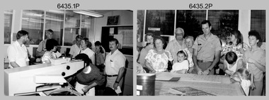
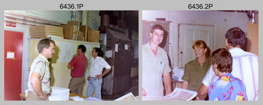
Photograph - Army Survey Regiment Open Day – Lithographic Squadron, Fortuna, Bendigo, 1990
These 18 photographs were taken at an Army Survey Regiment Open Day at Fortuna Villa, Bendigo on the 24th of February 1990. This occasion was one of several events held to commemorate the 75th anniversary of the formation of the Royal Australian Survey Corps. Although historical tours of Fortuna occurred on a regular basis, this was the first technical open day since 1972. The Royal Australian Survey Corps recognised that an Open Day was the best way for the local community in Bendigo to gain an insight into the unit’s important role as Defence’s map production agency, its technical equipment, and its economic importance to Bendigo. It also gave them an opportunity to tour through historic Fortuna Villa. This occasion is covered in more detail in page 143 of Valerie Lovejoy’s book 'Mapmakers of Fortuna – A history of the Army Survey Regiment’ ISBN: 0-646-42120-4. Refer to items 6434.27P and 6435.35P for more photos of the Open Day taken inside Fortuna, the garden areas and Map Production areas of Air Survey and Cartographic Squadron. Photo prints of some of these photos were scanned and catalogued in items 6247.30P and 6291.6P.These 18 photographs were taken at an Army Survey Regiment Open Day held at Fortuna, Bendigo on the 24th of February 1990. The 35mm colour and black & white negatives photographs were scanned at 96 dpi and are part of the Army Survey Regiment’s Collection. .1) - Photo, colour, 1990. Print Troop – WO2 Rob Bogumil with visitors. .2) - Photo, colour, 1990. Print Troop – L to R: SPR Ross Anza, LCPL Janet Murray with visitors. .3) - Photo, black & white, 1990. Print Troop – L to R: LCPL Janet Murray, MAJ Bob Coote, SPR Gary Lord with visitors. .4) - Photo, black & white, 1990. Photo Troop – L to R: WO2 Keith Fenton RE UK Exchange, SGT Steve Burke with visitors. .5) - Photo, colour, 1990. Photo Troop – SGT Steve Burke with visitors. .6) - Photo, colour, 1990. Photo Troop – L to R: unidentified, SGT Steve Burke with visitors. .7) - Photo, colour, 1990. Print Troop – L to R: CPL Peter Breukel, WO2 Keith Fenton RE. UK Exchange with visitors. .8) - Photo, black & white, 1990. Photo Troop - WO2 Keith Fenton RE. UK Exchange. .9) - Photo, black & white, 1990. Print Troop - civilian visitors. .10) - black & white, Print Troop, 1990. - L to R: civilian visitors, SSGT Ian Nichols, CPL John ‘Flash’ Anderson. .11) - Photo, black & white, 1990. Print Troop - L to R: SSGT Ian Nichols, CPL Dale Hudson, Planeta printing press, with civilian visitors. .12) - Photo, colour, 1990. Print Troop - L to R: SSGT Ian Nichols, CAPT Roger Hancock with civilian visitors. .13) - Photo, colour, 1990. Print Troop - LT Marty Lyons with civilian visitors. .14) - Photo, black & white, 1990. Print Troop - L to R: LT Marty Lyons, unidentified with civilian visitors. .15) - Photo, black & white, 1990. Orthophoto Mapping Section - L to R: SSGT Peter Imeson, SGT Bob Garritty with civilian visitors. .16) - Photo, colour, 1990. Optronics raster scanner - WO2 Adrian ‘Charlie’ Creedy with civilian visitors. .17) - Photo, colour 1990. Outside Photo Troop office - L to R: SSGT Rhys De Laine, WO2 Rob Bogumil. .18) - Photo, black & white, 1990. Photo Troop - civilian visitors..1P to .18P – no annotationsroyal australian survey corps, rasvy, army survey regiment, army svy regt, fortuna, asr, litho sqn -
Lakes Entrance Historical Society
Book, Bird, Eric and Lennon, Jane, The Entrance to the Gippsland Lakes, 1973
A scientific and historical study of the artificial entrance to the entrance to the Gippsland Lakes, victoria. Includes references, illustrations, mapsexploration, transport, commerce, civil engineering -
Bendigo Historical Society Inc.
Map - WALL MAP
Paper on canvas wall map. Street and Road map of City of Greater Bendigo, Borough of Eaglehawk and Surrounding Districts. Wooden hanging rod on top edge. Plastic rod on lower edge. Light brown background. Tw hanging tapes at centre of top hanging rod. Printed in black and red. Includes Street indexes, historical information and key to points of interest.eaglehawk, map -
 Victorian Railway History Library
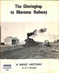
Booklet, McLean, D.C, The Gheringhap to Maroona Railway, 1968
A history of the Victorian Railway's Gheringhap to Maroona Railway in western Victoria, complied to coincide with the Australian Railway Historical Society, Victorian Division's special train tour to Ararat via Cressy on the 15th September 1973.ill, maps, p.22.non-fictionA history of the Victorian Railway's Gheringhap to Maroona Railway in western Victoria, complied to coincide with the Australian Railway Historical Society, Victorian Division's special train tour to Ararat via Cressy on the 15th September 1973.railroad construction - victoria - history, railroads -- victoria -- history -
 Victorian Railway History Library
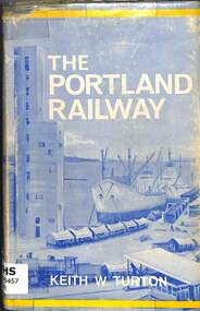
Book, Turton, Keith, The Portland Railway, 1968
A history of the rail network based on Portland that was developed from the 1870s to transport goods between its port and the growing inland settlements of Western Victoria and Southeast South Australiaill, maps, p.179.non-fictionA history of the rail network based on Portland that was developed from the 1870s to transport goods between its port and the growing inland settlements of Western Victoria and Southeast South Australiarailroad construction - victoria - history, railroads -- victoria -- history -
 Victorian Railway History Library
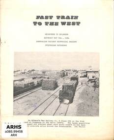
Booklet, Australian Railway Historical Society (Victorian Division), Fast Train to the West, 1964
A history of the Victorian Railway's branch line from Lubeck to Bolangum in western Victoria, complied to coincide with the Australian Railway Historical Society, Victorian Division's special train tour from Melbourne to Bolangum on Saturday the 9th May 1964.ill, maps, p.9.non-fictionA history of the Victorian Railway's branch line from Lubeck to Bolangum in western Victoria, complied to coincide with the Australian Railway Historical Society, Victorian Division's special train tour from Melbourne to Bolangum on Saturday the 9th May 1964.railroad construction - victoria - history, railroads -- victoria -- history