Showing 10832 items
matching maps
-
 Bendigo Historical Society Inc.
Map - WARRAGAMBA : COUNTY OF BENDIGO, 29-4-30
Map. Warragamba, County of Bendigo, Pannoomilloo, Kamarooka, Minto, Diggorra. By authority H.J. Green, Government Printer. Piccaninny Creek. Drawn and reproduced at the Deparment of Lands and Survey, Melbourne. 29-3-30. Price2/-. (number 10 in map cupboard 1)H.J. Green, Government Printermap, bendigo, warragamba -
Bendigo Historical Society Inc.
Map - WANURP : COUNTY OF BENDIGO, 1-12-33
Map. Wanurp, County of Bendigo, Terrick Terrick East, Mitiamo, Milloo, Pannoobamawm. By authority H.J. Green, Government Printer.Photo-Lithographed at the Department of Lands and Survey, Melbourne. Price 2/-. 1-12-33. (number 9 in map cupboard 1)H.J. Green, Government Printermap, bendigo, wanurp -
Bendigo Historical Society Inc.
Map - TALAMBE : COUNTY OF BENDIGO, January 1956
Map. Talambe, County of Bendigo, Hayanmi, Pompapiel, Dingee, Tandarra, Yallook. By authority W.M. Houston, Government Printer, Melbourne. Drawn and reproduced at the Department of Lands and Survey, Melbourne. January 1956. Price 2/-. (number 8 in map cupboard 1)W.M. Houston, Government Printermap, bendigo, talambe -
Bendigo Historical Society Inc.
Map - SEDGWICK : COUNTY OF BENDIGO, 1963
Map. Sedgwick, County of Bendigo, Strathfieldsaye, Eppalock, Lyell, Mandurang, Sutton Grange. By Authority A.C. Brooks, Government Printer, Melbourne. Drawn and reproduced at the Deparment of Lands and Survey, Melbourne. 1963. Price 2/-. (number 7 in map cupboard 1)A.C. Brooks, Government Printer.map, bendigo, sedgwick -
Bendigo Historical Society Inc.
Map - SALISBURY : COUNTY OF BENDIGO, 1965
Map. Salisbury, County of Bendigo, Pompapiel, Yarrayne, Yarraberb, Yallook, Bullock Creek. By Authority: A.C. Brooks, Government Printer, Melbourne. Drawn and reproduced at the Department of Lands and Survey, Melbourne.1965. Price $1.00. (number 6 in map cupboard 1)A.C. Brooks, Government Printermap, bendigo, salisbury -
 Sunshine and District Historical Society Incorporated
Map (1967), CITY OF SUNSHINE, June 1967, 1967
The City of Sunshine no longer exists. Part of the eastern area has been annexed by the City of Maribyrnong, and the rest of the old City of Sunshine has been amalgamated with the City of Keilor to form the larger City of Brimbank.This 1967 map is a historical record of the City of Sunshine as it existed 27 years before the amalgamation of Councils, and the creation of the City of Brimbank in 1994.Whitish paper map with black printing that is laminated in clear plastic film, and has a wood slat attached to the top edge. The June 1967 map is of the previous CITY OF SUNSHINE showing City and Parish boundaries, streets, railways, creeks, river etc.Purple ink stamps at top left hand and right hand areas showing address and contact details of 'Sunshine Industrial Promotion Centre.'city of sunshine, june 1967, map, city, parish, boundaries, brimbank -
 Kew Historical Society Inc
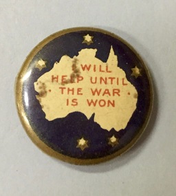
Badge - Fundraising Button, I Will Help Until the War is Won, 1916-1918
Frances Rigg was a local business identity in Kew, at one stage managing the local branch of the English, Scottish and Australian (ES&A) Bank at 175 High Street from c. 1920 until the 1940s. After Francis Rigg’s death, the collection of buttons and medallions was inherited by his son, Ken Rigg (1922-2014). The collection was subsequently donated to the Kew Historical Society in 2015 by Francis' grandson, Adrian Rigg, at the time of the Gallipoli & Beyond Commemoration in 2015. The collection covers a period of almost 40 years. The majority of the buttons are patriotic buttons, issued and sold during and immediately after the First World World War (1914-1918) to raise funds for national and overseas causes. The collection also includes a number of locally significant sporting event buttons and sporting club medallions, issued in the 1920s and 1930s.Patriotic and other pressed tin buttons and badges were produced in large numbers in the first decades of the twentieth century. By nature, insubstantial and ephemeral, they have not always survived. The collections of badges, buttons and medallions in the Kew Historical Society collection is homogenous and yet diverse, ranging from buttons sold to raise funds for the war efforts in 1914-18 and 1939-45, to those used at festivals and sporting events. Because of the manufacturing process, many surviving buttons and badges have been affected by inadequate storage, suffering from oxidisation and physical damage. These survivors are now historically and socially significant artefacts, revealing much about the attitudes and values of the period in which they were produced. Their widespread distribution means that they are frequently significant at a local, state, national and international level.Small circular pressed tinplate button featuring a white map of Australia on a dark blue ground with the stars of the Southern Cross surrounding, all within a gold border. The phrase ‘I Will Help Until the War is Won’ is printed in red across the map."I Will Help Until the War is Won"patriotic buttons, first world war (1914-18), badges -
 Clayton RSL Sub Branch
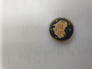
Button, I will help until the war is won
The use of these buttons as a means of raising revenue through patriotic sentiment occurred soon after Australia pledged allegiance to Empire. Buttons reflected ‘public sentiment, courage, patriotism, generosity and several [un- named] virtues’ such as the martyred mother of a ‘fallen’ hero. Attention was paid to attractiveness of design, encoded symbolism and high quality of production. Expressing ‘loyalty’, they were tokens to be kept for perpetuity. Female labour was used to operate the die that compressed the tin backing, photographic print and celluloid cover together. The pin was applied by hand. Women, of all ages, entered into the spirit of voluntary sales. Often they were sold at the entry and exit points of major pedestrian thoroughfares. . Pride in salesmanship was affected by publishing the name of the woman and her fiscal achievement in the major newspapers of the day.Small circular pressed tinplate button featuring a white map of Australia on a dark blue ground with the stars of the Southern Cross surrounding, all within a gold border. The phrase ‘I Will Help Until the War is Won’ is printed in red across the mapI will Help until the war is won -
 Lara RSL Sub Branch
Booklet, Map Reading Aide-Memoire 1973, 1973
Used by the Australian Army personnel to learn Map ReadingUsed by the Australian Army personnel to learn map readingA small rectangular booklet with cover and 26 pagesSee images of front cover and rear coveraustralian army, army, australia, map reading, booklet -
 Robin Boyd Foundation
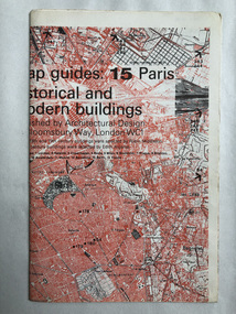
Map, Architectural Design, Map guides: 15 Paris historical and modern buildings
Map of significant Paris buildings and categorizing of historical buildings.map, paris, historical buildings, modern buildings, walsh st library -
Stawell Historical Society Inc
Book - Somerset, Florence Chuk, The Somerset Years, 1987
End maps: front Somerset Shire. Back VictoriaHardback with dust jacket, Beige. Colour print of mining scene, tent, women, men, minesGovernment Assisted Emigrants from Somerset and Bristol who arrived in Port Phillip Victoria 1839 - 1854 Author Florence Chuk. Signed by Author - Florence Chuk 14-11-89 -
 Orbost & District Historical Society
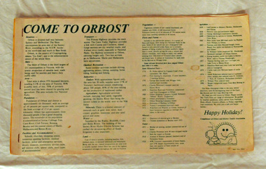
brochure, Come To Orbost, c 1980's
This brochure was produced as a tourist guide to Orbost.This item is a useful research tool.A magazine/brochure for use as tourist information. It contains the history, maps and touring routes of the Orbost district.tourism-orbost -
 Bendigo Military Museum
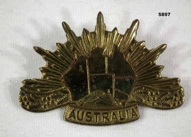
Badge - BADGE, RISING SUN DEPICTION, Post WW2
This badge was apparently made after WW2 and used on surplus Slouch hats being sold to the public. Item in the collection re John D Gardiner No 2832, refer Cat No 5892.2 for his service details.Badge cast gold colour with map of Australia centre with "Australia" under, two lugs on rear.badges, hats -
 Eltham District Historical Society Inc
Document - Folder, Eltham Cemetery, Mt Pleasant Road, Eltham, Vic, 2009-2010
Initially collated by Harry Gilham regarding the history of the cemetery and various developments and artworksarthur munday, cemetery gates, chappel terrace, eltham cemetery, gravedigger, james orford, justus jorgensen, lena cooper skipper, lily agnes jorgensen, mervyn g. skipper, svend erik kroyer-pedersen, vaults -
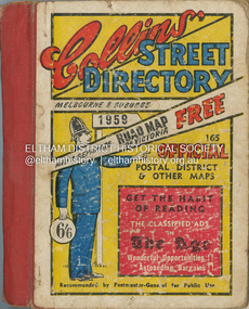 Eltham District Historical Society Inc
Book - Street Directory, Collins Book Depot Pty Ltd, Collins' Street Directory Melbourne & Suburbs, 1959, 1959
1 atlas (487 p.) : 123 maps ; 15 x 12 x 2.5 cm. melbourne maps, street directory -
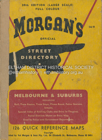 Eltham District Historical Society Inc
Book - Street Directory, Val Morgan and Sons Pty Ltd, Morgan's Official Street Directory of Melbourne & Suburbs, 39th edition, c.1959
1 atlas (204 p.) : 126 col. maps ; 25 cm. (Cover separated/loose)melbourne maps, street directory -
 Eltham District Historical Society Inc
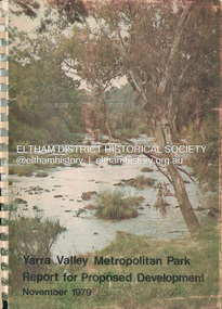
Book, Melbourne Metropolitan Board of Works, Yarra Valley Metropolitan Park : report for proposed development : a recreation, conservation and landscape planning study for the Melbourne and Metropolitan Board of Works, Metropolitan Parks Division / by Scott and Furphy Engineers Pty Ltd, Landscape Division, November 1979
melbourne metropolitan board of works, yarra river, yarra river valley, yarra valley metropolitan park -
 Eltham District Historical Society Inc
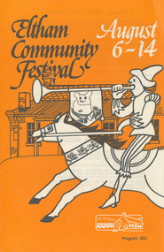
Program, Program of Events, Eltham Community Festival, 6-14 August 1977, 1977
Fold-out program printed both sides, 10 pages, including map (2 copies)One copy (Diana and Peter Bassett-Smith Collection) marked on cover in red pencil "1977"1977, diana and peter bassett-smith collection, eltham festival, program -
 Nhill Aviation Heritage Centre
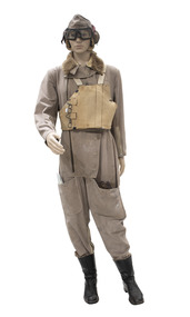
Uniform - Flying Suit, 1941
The Sidcot Pattern Flying Suit was the general suit used by the British AM (Air Ministry) during WW2. This suit dated 1941. Used by the RAF and the RAAF.Khaki flying suit with map pocket. Zips on front right side and sleeves. Lambswool collar -
 Bendigo Military Museum
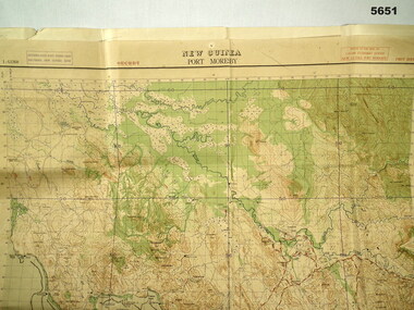
Map - MAP, PORT MORESBY 1943, 2/1st Aust Army TOPO SVY Coy, March 1943
In the collection re Capt R.A. Hanson VX111070, refer cat No 5646.3P for his service details.Map, Port Moresby area, colour, detailed, scale 1" - 1 mile, first Edition.In red, "1:63360 Standard series New Guinea, Port Moresby"map, new guinea, port moresby -
 Lara RSL Sub Branch
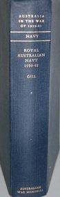
Book, Australia in the War of 1939. - 1945 Royal Australian Navy 1939 - 1942 Author is G.Herman Gill. Volume 1 Series 2, First Published in 1957
Australia in the War 1939-1945. Series 2 NAVY Volume 1Australia in the War of 1939-1945 - Royal Australian Navy 1939-1942 Maps, Photographs and IllustrationsInside front page has a handwritten letter on personal paper from George Herman Gill to Oscar Esther - June 1958. Inscription - Presented to Lara Sub Branch RSSAILA Lara, Vic by Squadron Leader O.A. Mendelssohn an old friend and admirer of the author, commander G.H. Gill OBE June 1958. Australian War Memorialnavy, ran ships overseas to june 1940, ran ships overseas june-december 1040, western desert campaign, greece, crete, the middle east, mediterranean to end of 1941, south-west pacific, abda and anzac -
 Lara RSL Sub Branch
Book, Australia in the War 1939-1945 Royal Australian Navy 1942-1945 Author G. Herman Gill, First Published 1968
Australia in the War of 1939-1945 Series 2 NAVY Volume 2Official Historic Record Series Australia in the War of 1939-1945 - Royal Australian Navy 1942-1945 Maps, Photographs, Illustrationswwii, navy, coral sea, guadalcanal, south west pacific, krait, strategy for victory, submarine swansong, wrans, tarakan, soloman islands, new guinea, largest amphibious attack - balikpapan, mindsweepers, coast watchers, hmas hobart, hmas vampire, hmas nestor, hmas canberra, hmas ballarat, hmas bendigo, hmas shropshire, hmas gasgoyne, hmas nizam, hmas arunta -
 Lara RSL Sub Branch
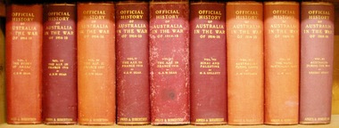
Book, Official History of Australia in the War of 1914-18 - Volume VII - Sinai and Palestine H.S. Gullett, 19388. fifth edition
Records the work of the Australian Lighthorse in the British campaigns in Sinai, Palestine and Syria during the years of 1916-17-18. An account of the strategies and tactics employed for the whole force. Historical narrative of Palestine, Sinai and Syria and Australian Lighthorse.Official History of Australia in the War of 1914-18 - Volume VII - Sinai and Palestine. Maps and Illustrations.light horse, sinai, palestine, syria, horses, turkish advance, gaza, magdhaba, allanby, beersheba, jerusalem, jordan valley, abu tellul, damascus -
 Bendigo Military Museum
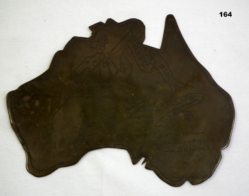
Memorabilia - TRENCH ART, WW1
Regarding P Sexton. There is a Patrick Sexton listed in the 59th Batt roll No 3243a. The trench art was in the collection of James Worland Mills No 3441 59th Batt AIF. Refer 169P, 166.3, 167.6. Map of Australia made from spent munitions brass; engraved with picture of soldier holding a banner.'59th Btn.' - written on Union Jack in corner of banner. 'Australia for Ever' written on 2nd banner. 'CD' written between soldier's feet. Other inscriptions: 'France 12.7.18', and 'P. Sexton Ville-Sur Ancre Somme.arms-ammunition, trench art -
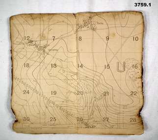 Bendigo Military Museum
Map - TRENCH MAPS WW1, 1918
Areas covered on both, “Villers Brettoneaux, Cachy, Hangard, Gentelles”. Items re William Alexander No 502 AIF. Refer Cat No 3746.3 for his service details.(.1 & .2) Both maps are same area, field survey 24.4.1918, scale 1:20,000.map, trench, france -
Federation University Historical Collection
Document, License under Section 19 of "The Land Act 1869", 1875
Full license and authority to enter and occupy Crown Land outlined was given to James Cowan. This was for a period of three years and subjected to conditions outlined on the document. The area was in the County of Bourke, Parish of Blackwood. The area concerned is located on the Lerderderg River in the Wombat State Forest. The fee for occupation was to be paid in advance by half-yearly payments to the Land Officer at Ballarat. The document signed on 1 July 1875 by William F Stawell, Acting Governor of Victoria.Thick pale blue paper. Hand written in ink Hand drawn map of land in questionDated 1 July 1875 Signed William F Stawelllicence, license, crown land, james cowan, county of bourke, parish of blackwood, lerderberg river, wombat state forest, william foster stawell, acting governor, land officer, ballarat -
Federation University Historical Collection
Pamphlet, Fletcher and Son Ltd, History on Display
Images and backgrounds histories and historical features/ Has a map of museum's location, as well as assitional information.ballarat historical society, museum -
 Bendigo Military Museum
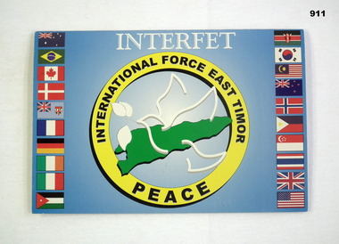
Postcard - XMAS CARD, 4/11/200
Interfet Christmas card. Blue background with flag border. Map of East Timor with peace dove.“INTERFET -International Force East Timor Peace” Postmarked Melbourne City Mail Centre November 2000documents-cards, maps, interfet, east timor -
Federation University Historical Collection
Map, Aboriginal Language Areas in Victoria: A Reconstruction
A4 sized map of Victoria showing Aboriginal Langauge Areas. Black, white and red writing aboriginal, aboriginal language, victoria, djadja wurrung, woi wurrung, watha wurrung, gadubanud, girai wurrung, dhauwurd wurrung, djab wurrung, wiradjuri, tatungalung, wadiwadi, dadidadi, yuyu -
 Marysville & District Historical Society
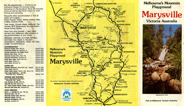
Ephemera (Item) - Tourist Guide, Melbourne's Mountain Playground Marysville Victoria Australia, Unknown
A fold out tourist guide to Marysville and the surrounding district.A fold out tourist guide to Marysville and the surrounding district.marysville, victoria, australia, steavenson falls, marysville golf club, cathedral range, blackwood holiday flats, cumberland holiday inn, kooringa conference and holiday centre, marylyn guest house, marysville caravan park, marysville hotel motel, nanda binya lodge, scenic motel, tower motel, cathedral restaurant, chris's place, danish coffee garden, tudor lodge roadhouse, buxton trout farm, silverstream trout farm, lake mountain ski hire, marysville fun park, mountain view horse hire, jl gould sawmills, marysville dairy, marysville drapery shop, marysville garage, marysville newsagency, top shop