Showing 11139 items
matching planning
-
 Bendigo Historical Society Inc.
Document - MINING REPORTS - NORTH JOHNSON'S MINE MANAGERS' REPORTS
The North Johnson Gold Mine was situated in California Gully, Bendigo. See Trove article and plan of mine: https://trove.nla.gov.au/newspaper/article/7918876Handwritten extracts, by Albert Richardson, with typed copy of same, from the North Johnsons Mine Managers, F. Agnew, G. Roberts and J. Veale's Reports dated from 8th July 1898 to 27th Feb 1908. Report mentions cage being hung up and rope being caught and stuck, cutting down of shaft, repair of winding rope, cutting down and timbering of shaft, miner burnt when candle flared, which was believed to be caused by gas, sinking of shaft and water heavy and recommend to stop sinking shaft and start to cut a plat. (b) Report dated 29-11-1906 mentions a typhoon destroying the east side of the engine-house. This was repaired and also cleaned flues and boilers and ventilation at 3273 and 3471 feet.gold, mining reports, north johnson's mine managers' reports, f agnew, p schadendorff, the 'rose' plant, g roberts, j veale, inspector williamson -
 Eltham District Historical Society Inc
Document - Property Binder, 672 Main Road, Eltham
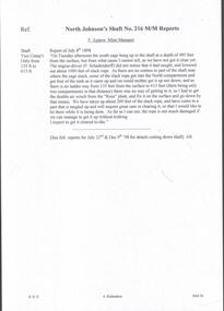
Flyer, Neville Emerson Pty Ltd, for sale Wingrove Cottage. Shire of Eltham Heritage Study, nd but post 1989: Wingrove Cottage. Note: June 1997 re Judy David, descendant of Mr Wingrove. Note: 2 September 2003: Greg Johnson description of building. Statement 2 September 2003 from Francis Percival (Jock) Read of memories of Wingrove Cottage. Copy letter 21 October 2002 from Value Creating Environments (recent purchasers of Wingrove site) to John Karageorge Planning and Building Services Nillumbik Shire re planned work; also attachment re possible site development. Newspaper article: Diamond Valley Leader, 23 October 2002, Angry crowd stops demolition, photograph of part demolition. Letter 30 December 2002 from Stephen Coleriro Acting Manager Planning and Building Services Nillumbik Shire re consultation on illegal demolition works at Wingrove Cottage. Letter 24 February 2003 from Allom Lovell & Associates to John Karageorge Shire of Nillumbik commenting on Wingrove Cottage work. Newspaper article: Diamond Valley Leader, 17 September 2003, Court orders restoration at cottage. Newspaper article: Diamond Valley Leader, 25 February 2004, Health vision for Eltham's 1800s home, Wingrove Cottage will be restored as health and wellness centre if plans approved. Newspaper article: Diamond Valley Leader, 7 July 2004, 1850s bricks in debris, Jim Cummane owner ordered to prepare conservation plan, photograph of site and Harry Gilham president Eltham District Historical Society. Newspaper article: Diamond Valley Leader, 1 December 2004, Cottage heritage plan crucial to sale success, site to be sold, photograph of Wingrove Cottage. Letter 14 April 2005 from Gaye Van Donkelaar Planning and Building Services Nillumbik Shire to Russell Yeoman Eltham District Historical Society re meeting of key stakeholders 27 April 2005. Newspaper article: Diamond Valley Leader, 28 March 2007, Cottage work on hold, recent purchasers Cameron Construction restored Cottage, open as photographic studio, applied for permit to build office and 7 homes on site. Letter 13 August 2007 from Senior Registrar VCAt to Eltham District Historical Society enclosing VCAT order re application for 672 Main Road. Letter 24 August 2007 from Colin Bowden Planning and Development Consultants to VCAT enclosing response prepared by O'Brien Traffic for VCAT. Letter 14 February 2007 from Jeremy Livingstone Planning and Building Services Nillumbik Shire, invitation to review re planning application.main road, eltham, property, houses, wingrove cottage -
 Ringwood and District Historical Society
Flyer, Executor's Auction Subdivision Advertisement, Lilydale Road and Oban Road, Ringwood East, Vic. - 1937
Single page advertisement for Executor's Auction of land in Ringwood East on Saturday, May 29, 1937 with locality map showing 26 building sites for auction highlighted in brown, and brief summary of local services available. Subdivision includes Old Lilydale Road, Joseph Street, Dynes Street, Albert Street (later Wyrunga Street), Carcoola Road, and Mount Dandeong Road. (Carcoola Road incorrectly shown as Oban Road on the subdivision plan). Auctioneer - C.E. Carter, (Phone Ringwood 24. -
 Ringwood and District Historical Society
Flyer, Land Sale Advertisement - State School Estate, Ringwood, Victoria - 1923
The date of the flyer as circa 1920 can be estimated from the references to the (decision on) "electrification of the Croydon Railway Line" which eventually occurred in 1923, letting of tenders for the state school building which opened in 1924, and the "proposed new railway station" (East Ringwood) which opened in 1925, Advertisement for State School Estate, Ringwood - 26 residential allotments for sale near East Ringwood State School development site and 7 minutes walk from proposed new railway station (East Ringwood). Includes location map and terms of sale.Locality plan includes King Street and Government Roads (Later Everard Road, Holland Road, Purser Avenue, and Charles Street). (Agents) J.B. McAlpin, Estate Agent and Subdivisional Manager, Ringwood (Opposite Station), and F.V. Parker, Estate Agent, Main Street, Ringwood. -
 Ringwood and District Historical Society
Newspaper, Scrapbook Clipping, Library Collection, Ringwood, Victoria
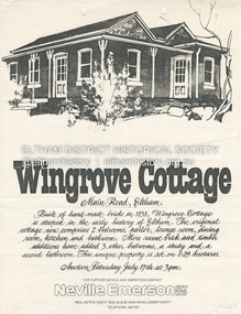
Newspaper Clipping from "The Mail", 3-10-95. P23. By Andrew Meath. Panel to have Say on LandAn independent panel will decide whether a housing subdivision in an environmentally sensitive part of North Ringwood should proceed. The Ministry of Planning and Development will appoint the panel to consider a request from developers of Barnsdale Forest to divide one acre (0.4 hectares) parcels of land into 7 lots -
 Ballarat Heritage Services
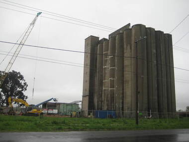
Photograph - Photograph - Colour, Lisa Gervasoni, Joe White Maltings Silos Under Demolition, 2010, 15/10/2010
"A plan to turn the Gregory Street silos into apartments is no more.Developers Eleveno Pty Ltd have abandoned plans to transform the Lake Wendouree silos into a giant apartment complex, despite previously being given the green light from the Victorian Civil and Administrative Tribunal.Director Richard Sykes yesterday confirmed the silos would be demolished."The plans are not proceeding. The plan now is to create residential houses," he said.The planning permit for an 18-lot subdivision was approved by Ballarat City Council on July 22, despite objections lodged against the application.Mr Sykes said it wasn't feasible to turn the silos into 27 units and there were many factors behind the decision."They're being demolished for various reasons, there were just better solutions," he said.Bold plans to transform the former Joe White Maltings silos into apartments were first submitted to Ballarat City Council in January 2007.However, developers took the proposal to VCAT in September 2008 after council failed to make a decision in the required 60-day timeframe.A hearing was held in early 2009 and the development was approved in March last year.Mr Sykes said it was found that the building would most likely be out of place in the region."We found the market didn't really want that sort of development," he said."They're probably more suited for inner-city development, rather than regional areas."Mr Sykes did not put a price on either the proposed development or the demolition, but said it would "cost a fair amount of money".He said once the demolition permit has been passed, works were expected to begin in November." (Ballarat Courier, 03 August 2010)Joe White Maltings Silos in Gregory Street Ballarat under demolition, to make way for a housing development. The silos were built on the banks of Lake Wendouree. joe white maltings, silo, eleveno pty ltd, lake wendouree, demolition, gregory street ballarat, wendouree parade, architecture -
 Ringwood and District Historical Society
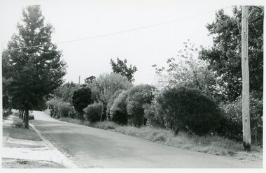
Photographs, Suda and Khassa Ave Ringwood, Before and after Ringwood Bypass Construction 1993
B&W photograph taken by Ringwood Historical Research Group. Also added extract from Melways showing the roads before the Bypass (1987) showing the planned Bypass cutting these two roads, and Melways (2018) showing new alignment with Bypass11063A: 17.1.93 Suda Ave Still intact towards Maroondah Hwy. Taken near Khassa Pde 11063B: 17.1.93 Suda Ave. House gone. Near Khassa Pde 11063C: 17.1.93 Ringwood Bypass from cnr Khassa Pde and Suda Ave towards Mt Dandenong Rd 11063D: 17.2.93 Suda Ave. House gone. 11063E: 21.2.93 cnr Khassa Pde and Suda Ave. Direction of next cut for the Ringwood Bypass. Trees to go. 11063F: 21.2.93 Connection from ??? St to North end of Suda Ave 11063G: 22.2.93 Adelaide St to right (closed). Mile Ave in front and turning left. Note the grey wall along Miles St to support the new car park development. Shrub on left is in the bowling club. -
 Ringwood and District Historical Society
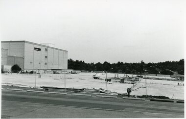
Photographs, Eastland Car park Construction, Ringwood, 1992-93
B&W photograph taken by Ringwood Historical Research Group. Also added extract from Melways showing the roads before the Bypass (1987) showing the planned Bypass cutting these two roads, and Melways (2018) showing new alignment with Bypass11064A: 21.2.92 Eastland car park development from near Safeway 11064B: 21.2.92 Eastland car park development from Adelaide St 11064C: 4.1.93 Eastland car park development from Warrandyte Road from Op. Bond St. 11064D: 4.1.93 New Myer Eastland car park viewed from Safeway's Roof 11064E: 17.1.93 Eastland car park near where Esso Garage was 11064F: 21.2.92 Eastland car park from cnr of Adelaide St and Eastland -
 Ringwood and District Historical Society
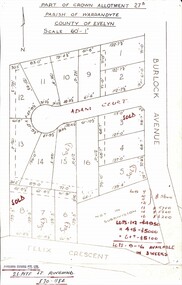
Map, Subdivision Plan - Adam Court area, North Ringwood, Vic. - circa 1960s
Single page plan printed showing allotments included in un-named subdivision layout surrounding Adam Court, Ringwood North. Subdivision includes Adam Court, Burlock Avenue, and Felix Crescent. Sold allotmenets marked in red, with price notations.Page heading - Part of Crown Allotment 27B Parish of Warrandyte County of Evelyn Scale 60'-1". Rubber stamp imprint and handwritten address at bottom of page - "Binburra Estates Pty. Ltd. 23 Pitt St., Ringwood, 870-1184". -
 Federation University Historical Collection
Booklet, Ballarat School of Mines Discussion Paper for a meeting with Hon. J.L. Simmonds, MP, 1985, 1985
Soft page booklet Ballarat prepared for a meeting with J.L. Simmonds, M.P. - Minister of Employment and Training and Representatives of Major Local Industries. Topics include corporate goal, priorities, I.S.O. COde of Practice, planned capital expenditure, programs and new initiatives. ballarat school of mines, smb campus, lydiard street, capital works, j.l. simmonds, lydiard st campus, corbould hall, motor mechanics, ballarat junior technical school building refurbishment, horticulture complex, grant st pedestrian overpass, court house refurbishment -
 Ringwood and District Historical Society
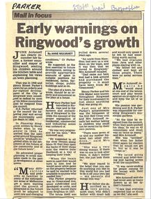
Newspaper, The Mail, June Antonoff on her father's life, Henry Ernest Parker
Obituary from The Ringwood Mail of Henry Ernest Parker by Anne Mulvaney, Ringwood Mail 27 February 1991. He was former Ringwood councillor and Mayor. June Antonoff, daughter, talked about him, especially about planning of Ringwood and gardens. -
 Bendigo Historical Society Inc.
Document - LA TROBE UNIVERSITY BENDIGO COLLECTION: THE PRESENTATION OF HISTORY 4
A brown folder titled "The Presentation of History 4". A teaching plan with which to teach the curriculum subject history. From the files of Mr. L.J. Pryor. Former Principal of Bendigo Teachers' College. Donated to Education Resource Centre for archival use 1992.bendigo, education, bendigo teachers' college, la trobe university bendigo collection, collection, bendigo, education, history, history - study and teaching, teaching, curriculum, stdents, mr. l.j. pryor, male, individual, person, education, resource centre -
 Bendigo Historical Society Inc.
Document - LA TROBE UNIVERSITY BENDIGO COLLECTION: THE HISTORY CURRICULUM 3
A brown folder titled "The History Curriculum 3". A teaching plan with which to teach the currculum subject history. From the files of Mr. L.J. Pryor. Former Principal of Bendigo Teachers' College. Donated to Education Resource Centre for archival use in 1992.bendigo, education, bendigo teachers' college, la trobe university bendigo collection, collection, bendigo teachers' college, bendigo, education, teaching, history, history - study and teaching, curriculum, mr. l.j. pryor, male, person, individual, education resource centre -
Bendigo Historical Society Inc.
Map - CAMPBELL COLLECTION: BENDIGO AND DISTRICT MAPS, 11-4-29
Map. Huntly, Parishes of Huntly Nerring and Neilborough. Scale 20 chains to 1 inch. Total area 4738 acres. Eaglehawk. Prepared in W.J.B. from A. and C.L. Plans by W.J.Galbraith 11-4-29. (number 396 in map cupboard 1)W.J.Galbraithmap, bendigo, agricultural lands -
Bendigo Historical Society Inc.
Map - CAMPBELL COLLECTION: BENDIGO AND DISTRICT MAPS, 14-6-29
Map. Terricks, Parish of Terrick Terrick West, scale 20 chains to 1 inch, total area 6318 acres, prepared in W.P.B. from Assessment and Parish Plans by W.J.G. 14-6-29. (number 388 in map cupboard 1)W.J.Galbraithmap, bendigo, agricultural lands -
Bendigo Historical Society Inc.
Photograph - FORTUNA COLLECTION: PLAN DRAWING FORTUNA VILLA
Plan of Fortuna villa entrance and garden elevations copied onto acetate material ( copies of original drawings). Written on top 'Fortuna Villa, G. Lansell Esq. Scale 8 feet to one inch.' Possibly originals drawn by W. Beebe.bendigo, house, fortuna villa -
Port Melbourne Historical & Preservation Society
Plan - Annotated and handcoloured by Peter Libbis to indicate his research into Libbis family residences and hotels on copy of a section of an MMBW map, Melbourne and Metropolitan Board of Works, c. 1980s
Peter LIBBIS obtained these copies from the MMBW when he researched his family history in the 1980s. He has annotated them, colour in hotels etc. Donated to Society in 1997.One of a group of 19 photocopies of various 20th century MMBW plans, annotated/coloured in to indicate residences of Libbis family and local hotels, by Peter LIBBIS in family and hotel research - Railway yards, Ross and Clark, South Graham c 1950sbusiness and traders - hotels, built environment - domestic, transport - railways, melbourne and metropolitan board of works, libbis family -
 Bendigo Historical Society Inc.
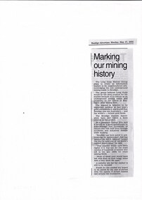
Document - LONG GULLY HISTORY GROUP COLLECTION: MARKING OUR MINING HISTORY
Copy of a newspaper article titled Marking our mining history printed in the Bendigo Adveretiser 27/5/2002. the Long Gully History Group plans to create an information marker in its neighbourhood acknowledging the role underground mining made to Bendigo.bendigo, history, long gully history group, the long gully history group - marking our mining history, long gully history group, the bendigo cornish association, george ellis, bendigo advertiser -
Whitehorse Historical Society Inc.
Document, Municipal Chambers, Nunawading, 23/07/2001 12:00:00 AM
Papers relating to applications for Council permits, objections and VCAT hearingsPapers relating to applications for Council permits, objections and VCAT hearings concerning development of 360-362 Whitehorse Road, Nunawading, and of 13 Walkers Road, Nunawading. Includes maps, plans, photos and architectural assessment of 360 Whitehorse Road by Andrew Ward.Papers relating to applications for Council permits, objections and VCAT hearings associated planning consultants, arrowsmith, valda, nunawading and district historical society, municipal chambers, whitehorse road, nunawading, no 360, no 362, walkers road, no. 13, victorian civil and administrative tribunal, ward, andrew, city of whitehorse -
Whitehorse Historical Society Inc.
Document, Civic Centre Amphitheatre Floor, 1995
Program, plan, publicity and other documents relating to the City of Whitehorse Civic Centre Amphitheatre Floor Ceramic Tile Project.Program, plan, publicity and other documents relating to the City of Whitehorse Civic Centre Amphitheatre Floor Ceramic Tile Project. Nineteen schools worked on the project, under the auspices of the Nunawading Schools Community Arts Project. Photos at NP 3606-3624Program, plan, publicity and other documents relating to the City of Whitehorse Civic Centre Amphitheatre Floor Ceramic Tile Project.nunawading schools community arts project, city of nunawading, tiles -
 Whitehorse Historical Society Inc.
Document, Gordon Crescent, 4/09/1890
Photocopy of Certificate of Title Vol. 2296 Fol 45903S, being part of Lots 46, 47 and 48, Plan of Subdivision No 2400, part Crown Portion 82 to Martha Quarterman 4 September 1890, transferred to Finlay Urquhart 5March 1946.gordon crescent, blackburn, central road, quarterman, martha, urquhart, finlay, land subdivision -
 Whitehorse Historical Society Inc.
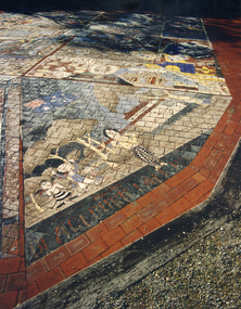
Photograph, Nunawading Primary Schools Community Art Project -2004-5, 1/06/2005 12:00:00 AM
See ND5890One of a set of 19 coloured photographs relating to the Ceramic Tile Project by the Nunawading Primary Schools Community Art Project which was installed in the Amphitheatre at the rear of the Nunawading Civic Centre. This Photo is a general View. Text, Plans & Publicity - see ND5890nunawading primary schools community art project., city of whitehorse. civic centre, ceramic tile project, civic centre -
 Bendigo Historical Society Inc.
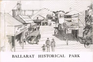
Book - MERLE HALL COLLECTION: BOOKLET: ''BALLARAT HISTORICAL PARK''
Booklet: ''Ballarat Historical Park'' B&W illustrated booklet (''A Presentation of the Project of the Ballarat Historical Park Association'' re Sovereign Hill. - formation of the Association; story of Sovereign Hill; the site and the plan; potential as a tourist centre; committee and consultants listed. -
 University of Melbourne, Burnley Campus Archives
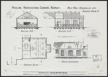
Plan, Pavilion, Horticultural Gardens, Burnley, 1916
1 large and 2 identical smaller photocopies. Pavilion, Horticultural Gardens, Burnley. Elevations and Ground Plan of "West Wing Remodelled into Science Room." Stamp GB 5173. Stamp date Dec 7th 1916. From Public Records Office.pavilion, burnley gardens, burnley school of horticulture -
University of Melbourne, Burnley Campus Archives
Book, Market Garden, 1956
No. 01310H Norman Bros. Pty. ltd. 60-62 Elizabeth St., Melbourneorchard, field station, vegetables, cropping, market garden, nutrients -
University of Melbourne, Burnley Campus Archives
Plan, Light Framed Lecture Theatre, 1989-1990
-
Canterbury History Group
Ephemera - An opportunity awaits, 77 Highfield Road Canterbury, 2007
Real estate brochure for the sale of 77 Highfield Road Canterbury by auction on 7 July 2007. Includes a coloured photograph of the exterior and floor and site plan. Also a note by Robin Kelly that the property was sold for $1.3 million (September 2007) to be demolished.canterbury, highfield road, edwardian style -
 Bacchus Marsh & District Historical Society
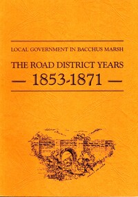
Book, John Lloyd, The Road District Years, 1853-1871: Local Government in Bacchus Marsh
This work describes the early evolution and history of local government in the Bacchus Marsh area. Local government bodies in Victoria and in other places had their origins in committees and local boards which were established to regulate over pressing local issues, raise revenue, and expend it in a limited range of social and economic ways. The early areas of responsibility were dominated by the need for local roads and this book primarily looks at this period of local government history in the Bacchus Marsh area. Overtime the range of areas local government bodies took responsibility for expanded and this work begins to trace this transformation in its earliest stages. It is a fascinating and detailed account of the early history of local government in Bacchus Marsh containing many amusing anecdotes among the wealth of administrative historical data. The author who was at one time an employee of the Shire of Bacchus Marsh has drawn directly from the early local records such as minutes of meetings, records of expenditure, newspaper reports and notices in the Victoria Government Gazette.Soft cover foolscap size book. 128 pages with b & w illustrations, maps and plans. No publisher is indicated in the work but it is likely to have been privately published by the author John Lloyd. Year and place of publication is 1986, Bacchus Marsh, Victoria.non-fictionThis work describes the early evolution and history of local government in the Bacchus Marsh area. Local government bodies in Victoria and in other places had their origins in committees and local boards which were established to regulate over pressing local issues, raise revenue, and expend it in a limited range of social and economic ways. The early areas of responsibility were dominated by the need for local roads and this book primarily looks at this period of local government history in the Bacchus Marsh area. Overtime the range of areas local government bodies took responsibility for expanded and this work begins to trace this transformation in its earliest stages. It is a fascinating and detailed account of the early history of local government in Bacchus Marsh containing many amusing anecdotes among the wealth of administrative historical data. The author who was at one time an employee of the Shire of Bacchus Marsh has drawn directly from the early local records such as minutes of meetings, records of expenditure, newspaper reports and notices in the Victoria Government Gazette.bacchus marsh shire council, local government bacchus marsh history -
 Tarnagulla History Archive
Telegram: Bagge to Inspector General of Public Works, 14th October, 1863
Murray Comrie Collection. A telegram sent from a C.H.O. Bagge in Tarnagulla to the Inspector General of Public Works in Melbourne on October 14th, 1863. Concerns checking of water levels in Inglewood and Tarnagulla Reservoirs, cost to build water races and planned travels to Dunolly and St. Arnaud.tarnagulla, post office, telegrams, bagge, water, resources, inspector general of public works, infrastructure, correspondence, communication, government -
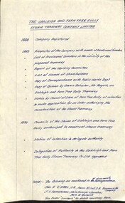 Melbourne Tram Museum
Document - Research Notes, H. S. McComb, "The Oakleigh and Ferntree Gully Steam Tramway Company Limited", 1960's?
Handwritten timeline on foolscap paper, titled "The Oakleigh and Ferntree Gully Steam Tramway Company Limited", giving years and events and reference documents with reference on the second page to a sketch plan from various documents. Dates 1888 to 1890. Map not with document.trams, tramways, steam trams, oakleigh, ferntree gully