Showing 10832 items
matching maps
-
 4th/19th Prince of Wales's Light Horse Regiment Unit History Room
Magazine Publication, Army Magazine, ARMY, 1945
"ARMY" Magazine for Feb-March 1945 dealing with Australian troops in the Pacific war, with photos and mapsWW2, Pacific -
 Phillip Island and District Historical Society Inc.
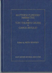
Book - Book, hardcover, Matthew Flinders' narrative of Tom Thumb's cruise to Canoe Rivulet, 1985
Flinders recorded this "cruize" of the Tom Thumb in the form of a Narrative, together with his account of the Schooner Francis's expedition to the Furneaux Islands.xvii, 34 p., [1] leaf of plates : ill., facsims., map, ports. ; 26 cm. matthew flinders tom thumb canoe rivulet keith bowden south eastern historical association pakenham gazette schooner francis furneaux islands, navigation exploration -
 Mission to Seafarers Victoria
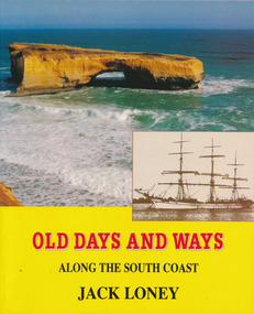
Book, Jack Loney, Old Days and Ways Along the South Coast, 1992
78 p., [30] p. of plates : ill. (some col.), maps, ports. (some col.)non-fictionaustralia, shipping, shipwrecks, jack loney (1925-1995) -
 Phillip Island and District Historical Society Inc.
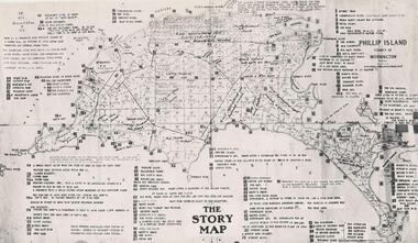
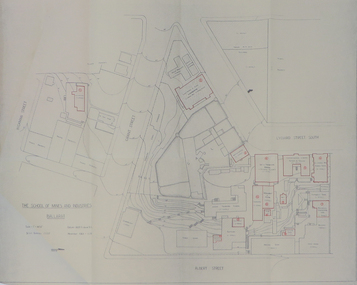
Photograph
One of a collection of over 400 photographs in an album commenced in 1960 and presented to the Phillip Island & Westernport Historical Society by the Shire of Phillip IslandPhotograph of the original draft of the map making of the end papers for the book "Phillip Island in Picture & Story"local history, photography, map of phillip island, black & white photograph, maps & mapping, phillip island in picture & story, john jenner, bryant west -
 Greensborough Historical Society
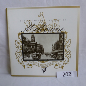
Booklet, The History of the City of Melbourne, 1997_11
The history of the Melbourne City councilHistorical notes on the foundation of Melbourne and the creation and growth of the Melbourne Cricket Club.44 page booklet, printed in black and white, illus., maps. With gold highlighting on the outer coversNilmelbourne settlement, melbourne landsales, melbourne local government, john batman, john pascoe fawkner -
 Greensborough Historical Society
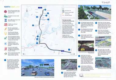
Leaflet, North East Link community update 04 April 2018; and, Map of proposed North East Link, 2018_04
Updates on North East Link project.1 sheet, printed in colour both sides (update) and single sided colour map and notes.north east link -
 Greensborough Historical Society
Article, Greenhills State School no.4893 (1962-1964): by Dawn Bennetts - GH4893, 1962-1964
Greenhills Primary School celebrated its 50 year anniversary and reunion in 2012. In this story, pupil Dawn Bennetts (nee Petts) recalls early memories of the school.Recalls early days at Greenhills Primary School. There appears to be few records surviving from the early days.2 pages of typed text. Copy 2 (3 Pages) amended with photographs and map of school.greenhills primary school, greenhills state school, dawn bennetts, dawn petts -
 Greensborough Historical Society
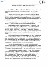
Pamphlet, Olinda Heritage Walk: official souvenir guide, by Mount Dandenong and District Historical Society Inc, 2016_
Walking guide to early Olinda buildings 1905-191524 p. pamphlet, map, photographs, with accompanying postcard from Patricia Hogan to Noel Withersolinda, mount dandenong -
Glenelg Shire Council Cultural Collection
Pamphlet, Portland Holiday Centre of the South West, 1970s
Trifold pamphlet 'Portland Holiday Centre of the South West'. Coloured photos, map, tours and information. -
Glenelg Shire Council Cultural Collection
Map - Map - West Sinclair Station, 1854
Map of West Sinclair Station. Hand drawn in black ink on khaki paper, glued to cardboard.west sinclair station -
 Greensborough Historical Society
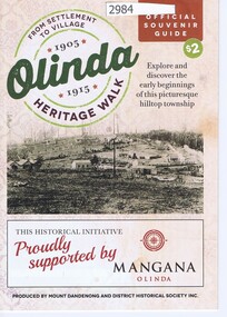
Report, Lower Plenty River Archaeological Survey; Fiona Weaver, 1989_
Archaeological survey of the Lower Plenty River undertaken in 1989-1990 by Fiona Weaver for the Board of Works. Indigenous heritage sites along the Plenty River are examined and recommendations made for the preservation and to lessen the impact of development on these sites.Printed on white A4 paper. Approx 92 pages (not numbered). Illus., maps. 2 copies.plenty river, board of works, aboriginal heritage sites -
 Greensborough Historical Society
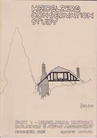
Book, Heidelberg Conservation Study: Part 1 Historic Buildings and Areas Assessment, 1985_
Report prepared by Graeme Butler on behalf of City of Heidelberg and Heidelberg Heritage Advisory Committee. Area covered is from Eaglemont in the south to Macleod in the north.This study identifies neighbourhood character, documents past development and the capacity of the environment for future development.Part one of set of three books. Paperback, 189 pages, Illus., maps. 2 copies.Stamps: Yarra Plenty Regional Library Service, and, Withdrawnheidelberg, macleod, heidelberg heritage advisory committee, graeme butler, plenty river, eaglemont -
 Greensborough Historical Society
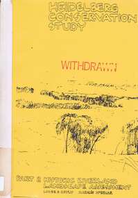
Book, Heidelberg Conservation Study: Part 2: Historic Riverland Landscape Assessment. Revised 1987, 1987_
Report prepared by Loder and Bayly and Marilyn McBriar on behalf of City of Heidelberg and Heidelberg Heritage Advisory Committee. Area covered is from Darebin Parklands in the south to Plenty River at Yallambie in the north. Revised 1987.This study identifies neighbourhood character, documents past development and the capacity of the environment for future development with particular emphasis on the river precincts - Plenty River, Yarra River and Darebin Creek.Part three of set of three books. Paperback, 333 pages, Illus., maps. 2 copies.Stamps: Yarra Plenty Regional Library Service, and, Withdrawnheidelberg, macleod, heidelberg heritage advisory committee, marilyn mcbriar, plenty river, yarra river, darebin creek -
4th/19th Prince of Wales's Light Horse Regiment Unit History Room
Booklet, Map Reading Aide-Memoire 1973, 1973
Soft covered booklet aimed at assisting with most map reading and navigation problems. 2 copiesDSN 7610-66-058-5570map reading -
 Kiewa Valley Historical Society
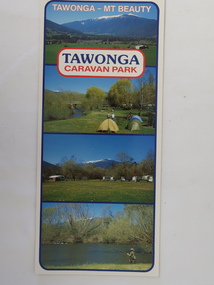
Brochure - Tawonga Caravan Park, Tawonga - Mt Beauty
Tawonga Caravan park is on the Kiewa River situated north of Mt Beauty and 30 km from Falls Creek. Tawonga Caravan park has always been popular for families and fishermen with plenty to do.Colored cardboard brochure with 3 small photos on the front and information printed on the back with a small map.tawonga caravan park, trout fishing -
4th/19th Prince of Wales's Light Horse Regiment Unit History Room
Pamphlet (2 copies), Map Marking. Military Symbols, abt 1960's
A soft covered pamphlet showing the military map symbols agreed for use in the forces of SEATO, with explanationsmap symbols -
 Eltham District Historical Society Inc
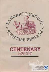
Book, Bruce Bence, Kangaroo Ground Bush Fire Brigade, centenary 1892-1992 : the story of the Kangaroo Ground Fire Brigade / Bruce Bence, 1992
Contents (described as Index): The early days, Ewen Hugh Cameron, 1914-1939, Supporting organisations, Eltham Emergency Operations Centre, Kangaroo Ground Fire Brigade Ladies Auxiliary, The fire tower, the Salvation Army and Red Cross, 1930-1992, The Kangaroo Ground Fire Brigade Today, Kangaroo Ground Fire Brigade Chronology. Includes a list of names of office bearers. Also includes references to neighbouring brigades and copies of historical newspaper articles. This publication was supported by the resources, information and facilities of The Shire of Eltham Historical Society.This book is significant in that not only does it traces the development of Kangaroo Ground Bush fire brigade since 1892 and of emergency services in the area but it also gives an insight into the people and their community.Softcover; 61 p., [7] p. of plates : b&w ill., 7 maps, ports.ISBN 064606651Xkangaroo ground, fire brigades, emeregency services, kangaroo ground fire brigade, fires, bush fires, shire of eltham war memorial, kangaroo ground tower -
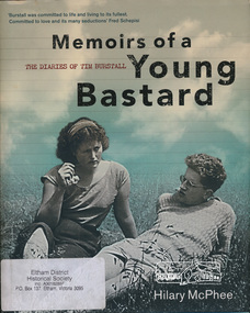 Eltham District Historical Society Inc
Book, Miegunyah Press, Memoirs of a Young Bastard: the diaries of Tim Burstall compiled by Hilary McPhee, 2012
Diaries of Tim Burstall November 1953 to December 1954. Tim Burstall lived in Eltham.xxiv, 343 p., [18] p. of plates : ill., maps, ports., facsims. ; 27 cm.ISBN 9780522858143moving pictures australia -
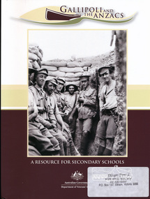 Eltham District Historical Society Inc
Book, Department of Veterans' Affairs, Gallipoli and the Anzacs : a resource for secondary schools. (includes a CD-ROM), 2010
120 pages : color illustrations, maps ; 30 cm + 1 DVD, 1 DVD-ROM.ISBN 9781877007514 187700751X -
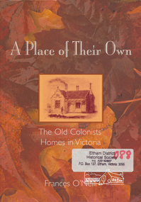 Eltham District Historical Society Inc
Book, Frances O'Neill, A place of their own : the old colonists' homes in Victoria / Frances O'Neill, 2005
Paperback; viii, 201 p., [16] p. of plates : ill., maps, ports. ; 25 cmISBN 1740970675houses, buildings, victoria -
 Orbost & District Historical Society
Book - front cover, The Corringle Creek to Sydenham Inlet Coastal Reserve A RESOURCES STUDY, 1977
This 1977 Resources Study was a joint project of the Shire of Orbost & the Dept. of Crown Lands & Survey with the purpose of collating information on natural resources, pattern of public use, and constraints on future use so that management can be formulated.This report gives and understanding of the resources and management directions of coastal land in East Gippsland in 1977. A buff coloured cover with black printing and blue tape binding. 71 pages + maps/charts. THE CORRINGLE CREEK TO SYDENHAM INLET COASTAL RESERVE. A resources study with comment on the implications for management by IAN R. BROWN Research officer and PETER B. LAVERY Land Management Oficer. Coastal management Committee Victoria 1977. Published under the authority of the Coastal Management Committee by the Department of Crown Lands and Survey, Victoria 1977. Printed by James Yeates Printing, Bairnsdale 3875.corringle creek, sydenham inlet, natural resources survey -
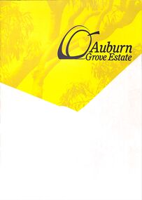 Ringwood and District Historical Society
Pamphlet - Land Sale Brochure, Auburn Grove Estate Ringwood East - circa 2012
Estate offers country living in the heart of the leafy eastern suburbs flanking Tintern Grammar School farm.Trifold pamphlet advertising Auburn Grove Estate with maps and layout of subdivision and photographs of area. No dates.Estate plan includes Longview Road, Auburn Grove, and Gracedale Avenue. -
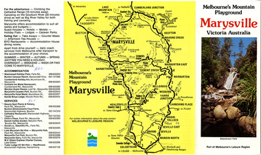 Marysville & District Historical Society
Ephemera (Item) - Tourist Guide, Melbourne's Mountain Playground Marysville Victoria Australia, Unknown
A fold out tourist guide to Marysville and the surrounding district.A fold out tourist guide to Marysville and the surrounding district.marysville, victoria, australia, steavenson falls, marysville golf club, cathedral range, blackwood holiday flats, cumberland holiday inn, kooringa conference and holiday centre, marylyn guest house, marysville caravan park, marysville hotel motel, nanda binya lodge, scenic motel, tower motel, cathedral restaurant, chris's place, danish coffee garden, tudor lodge roadhouse, buxton trout farm, silverstream trout farm, lake mountain ski hire, marysville fun park, mountain view horse hire, jl gould sawmills, marysville dairy, marysville drapery shop, marysville garage, marysville newsagency, top shop -
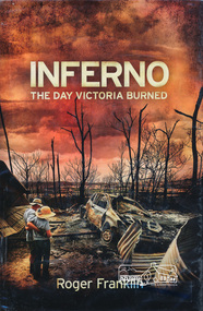 Eltham District Historical Society Inc
Book, Roger Franklin, Inferno: The Day Victoria Burned by Roger Franklin, 2009
Description of bush fires in Victoria on Black Saturday 7 February 2009267 p., [16] p. of plates : ill. (chiefly col.), maps, ports. ; 25 cm.ISBN black saturday, bush fires victoria -
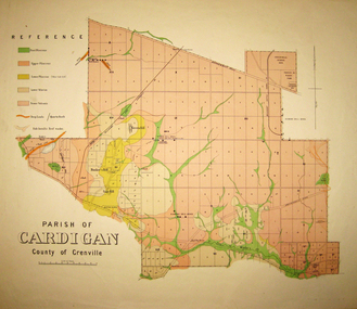 Federation University Historical Collection
Map - Geological survey, Parish of Cardigan, County of Grenville, c1889
Geological map of the Parish of Cardigan on a cadastral base showing quartz reefs, shafts, alluvial deposits.cardigan, winter's creek, ballarat cattle yards railway, prince of wales park, ballarat, friendly societies reserve, ballarat industrial school reserve, green hill, bunker's hill, sago hill, diamond drill bores, cardigan propriety, half way house, ti tree creek, albion consols, prince imperial, winter's freehold company -
Federation University Historical Collection
Plan, Shire of Buninyong Warrenheip water supply general management
The Shire of Buninyong was later amalgamated into the City of Ballarat.Map shows the 1966 district boundaries of Ballarat and the layout of properties and water pipes in Warrenheip 1966.Gutteridge, Haskins & Davey Consulting Engineers Shire of Buninyong Warrenheip water supply general management September 1966buninyong, vincent, warrenheip, gutteridge, haskins & davey, water supply -
 Federation University Historical Collection
Plan, Parish of Dowling Forest, County of Ripon and Grenville, 19
Scale [1:31 680]. 40 chains to 1 in.Geological map on a cadastral base, showing the occurence of reefs, and alluvial deposits. Relief shown by contours.dowling forest, wyndholm, wyndholm pre-emptive right, miners rest, ballarat racecourse, winter's swamp, police reserve, miner's rest, winters swamp, geology -
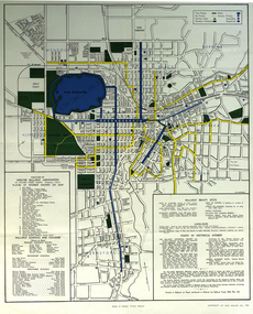 Federation University Historical Collection
Map, Greater Ballarat, 1968, 07/1968
Coloured street map of Greater Ballarat, including Sebastopol, and portions of the Shires of Ballarat, Buninyong, and Grenville.ballarat, map, greater ballarat association, sebstopol, canadian, eureka, alfredton, wendouree, ballarat east, mount pleasant, zilles print -
 Federation University Historical Collection
Report, SMB: Budgetary Planning 1970/72; Buildings and other Capital Equipment Requirements, 1967/1968
Report typed on A4 paper stapled together Includes two large map - folded to firballarat school of mines, plans, buildings -
 Federation University Historical Collection
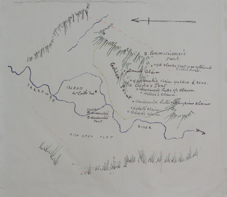
Plan, Dunn's Map of Early Gold Diggers at Golden Point, Ballarat, not dated
Hand drawn map in colour showing Yarrowee River and claims including James Oddie and Highett.dunn, dunn's map, comissioner's tent, oddie's claim, highett's claim, macdonald, suter & co claim, james oddie, golden point, gold discovery