Showing 175089 items
matching nellie-street
-
 Stawell Historical Society Inc
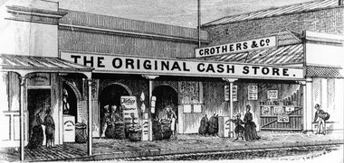
Drawing, Mr Crothers & Co, Grocer in Upper Main Street Stawell from the P.C. News Supplement 1888 -- Sketch
Crothers & Co Grocer Upper Main Street Stawell from P.C. News Supplement 1888stawell businesses -
 Stawell Historical Society Inc
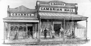
Drawing, G. Barnes & Cambrian Hall, Draper in Main Street Stawell from the P.C. News Supplement 1888 -- Sketch
G. Barnes Cambrian Hall Draper Main Street from P.C. News Supplement 1888stawell businesses -
 Stawell Historical Society Inc
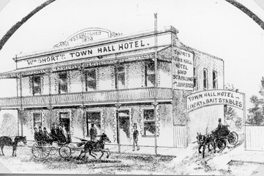
Drawing, "Shorts" Town Hall Hotel in Main Street Stawell from the P.C. News Supplement 1888 -- 2 Sketches
Richards Town Hall Hotel Main Street Stawell from P.C. News Supplement 1888stawell businesses -
 Stawell Historical Society Inc
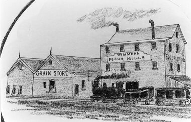
Drawing, Wimmera Flour Mills and Grain Store in Taylor Street c1890 -- Sketch
Wimmera Flour Mills and Grain Store Taylor Street From Sketch series Circa 1890stawell businesses -
 Stawell Historical Society Inc
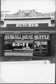
Photograph, Stawell Meat Supplies Butchers shop in Main Street Stawell built in 1876 1991
Stawell Meat Supplies Butchers shop in 1991 located in Main street in building built 1876 stawell business -
 Stawell Historical Society Inc
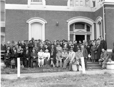
Photograph, Stawell Senior Citizens Club Formation with a large crowd on steps of "Oban" House in Scallan Street 1958
Senior Citizens Club Formation 1958 Group photo on steps of OBAN Scallan Street Stawell.stawell rsl -
 Stawell Historical Society Inc
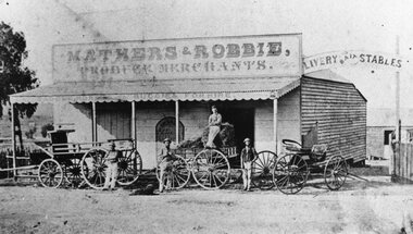
Photograph, Mathers & Robbie -- Produce Merchants in Patrick Street Stawell c1880
Business - Mathers & Robbie Produce Merchants. Patrick Street Stawell c1880 in vicinity of Secondary College.stawell -
 Stawell Historical Society Inc
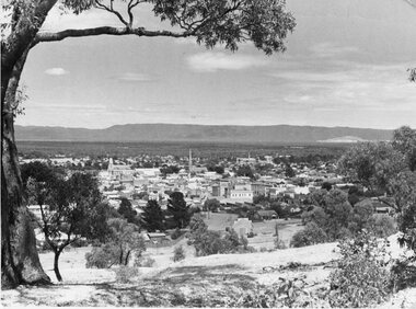
Photograph, Big Hill Area overlooking Stawell with Main Street and Grampians in the background
Scene from Big Hill Area overlooking Stawell showing Main Street and Grampians in Background.stawell -
 Greensborough Historical Society
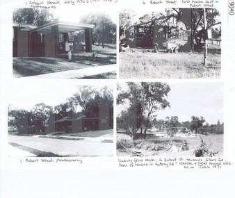
Photograph - Photograph (copy), Robert Street, Montmorency early 1970's, 1971-1972
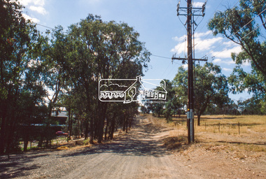
No. 1 and No. 4 Robert Street Montmorency are shown during the construction of homes on the sites c1971-1972A4 page, photocopy of black and white photosmontmorency, robert street montmorency -
 Whitehorse Historical Society Inc.
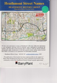
Booklet, Heathmont Street Names, 2020
A booklet on information of some of Heathmont's 140 streets38 pagesnon-fictionA booklet on information of some of Heathmont's 140 streetsheathmont, barry plant, heathmont history ghroup -
 Stawell Historical Society Inc
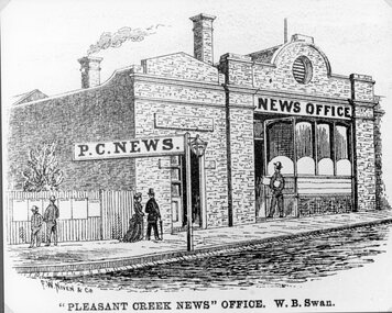
Drawing, Pleasant Creek News Office in Upper Main Street Stawell from the P.C. News Supplement 1888 -- Sketch
Pleasant Creek News Office upper Main Street from P.C. News Supplement 1888 Line drawing of news office"Pleasant Creek News" Office. W. B. Swan.stawell businesses -
 Eltham District Historical Society Inc
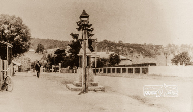
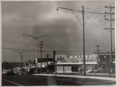
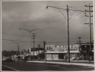
Photograph, Main Street, Greensborough, 1920s, 1920s
Looking towards the Plenty River from outside the current premises of the State Savings Bank. In the foreground is one of the old carbide street lamps. Behind the lamp is the drinking fountain erected as a memorial to Greensborough's Great War (First World War) Diggers. This memorial is now in the park in Henry Street, (Photo: Nillumbik Historical Society)Colour photograph copy originally located in a magnetic style album titled 'Greensborough Bypass 1990s 5' suffering significant degradation. No information contained in album or on reverse of photos except where noted. Relocated to archival photosafe storage.greensborough, main street -
 Eltham District Historical Society Inc
Book, Melway Publishing, Melway Greater Melbourne street directory : including Geelong, Phillip Island, Healesville, Bellarine & Mornington Peninsulas, 2002
Edition 29. Coloured detailed maps accessed by a street or location index. Cover: 20 additional pages of new maps, extended coverage of Bellarine Peninsula, further coverage of Werribee South, Public Transport Information, latest official suburb boundaries, CBD "hook turn" intersections map, over 1200 new streets, 1 atlas (24, 886 p.) : col. maps ; ISSN 03113957streets, roads, melbourne, maps, melway -
 Eltham District Historical Society Inc
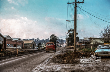
Photograph, Tillings timber yard, Bridge Street, Eltham, 1968, 1968
Photographer is standing on Bridge Street looking east on the main road to Greensborough from Eltham. Bridge Street under re-construction. Across the road from Tillings timber yard is Sharmac Industries which was a factory now occupied by Bunnings. It gave off a bad smell. This was the main light industrial area in the Shire of Eltham. Digital copy of colour photographfred mitchell collection, 1968, eltham, bridge street, n.j. tillings, tillings timber yard, light industrial area -
 City of Ballarat Libraries
Photograph, 1319 Sturt Street
1319 Sturt Street was built in 1928 for Dr. S.A. Wilson. It was a double brick residence with diagonal leadlight windows. Margaret Wilson and her mother can be seen in the second photo. In the third photo, Margaret by the tradesman's entrance in the garden. Along with 1321 Sturt Street, the house was demolished in 1962 and a Shell Service Station was built.building, private residence, s.a. wilson, margaret wilson, sturt street, ballarat, garden -
 Melbourne Tram Museum
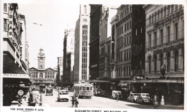
Postcard, Rose Stereograph Co, "Elizabeth Street, Melbourne, Vic", c1950
Rose Series postcard No. P 3726, titled "Elizabeth Street, Melbourne, Vic", looking south from near Little Collins St. Has a W5 class tram northbound. On the left is Brashes, in the distance is Flinders Street Railway station, and on the right the London Hotel, James McEwan & Co. with a sign for Sherwin Williams Paint.Yields information about Elizabeth Street from near Little Collins St. C1950Postcard - printed real photograph with Rose Stereograph Co. name on the rear. UsedHas a letter to Ken from R Williams written on the rear, dated 3-7-51 about a friend who had visited Christchurch. Same handwriting as 8098.trams, tramways, w5 class, elizabeth st. -
 Melbourne Tram Museum
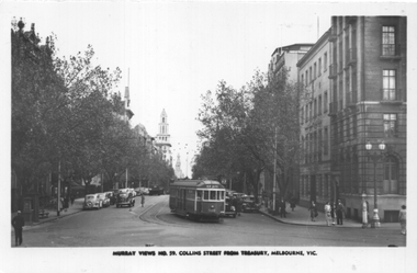
Postcard, Murray Views, "Collins Street Melbourne from Treasury, Melbourne Vic.", 1930s
Murray Views postcard No. 59, titled "Collins Street Melbourne from Treasury, Melbourne Vic." Has W2 class tram 509 route 47, Kew Depot turning from Collins St into Macarthur St. Thee is a lady waiting in the safety zone on the south side of the street. In the background is the T&G building.Yields information about Collins St, during the 1930s.Postcard - printed, unused, by Murray Views of Gympie Qld.trams, tramways, w2 class, collins st, tram 509 -
 Melbourne Tram Museum
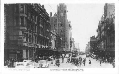
Postcard, Rose Stereograph Co, "Swanston Street Melbourne", early 1940s
Rose Series postcard No. P 1633, titled "Swanston Street Melbourne", looking north from about Flinders Lane. There are a number of W2's in the street with white painted panels under the driver's windows, and one car with a gas producer back. A set of traffic lights can be seen on both sides of Flinders Lane.Yields information about Flinders St station early 1940s.Postcard - printed real photograph with Rose Stereograph Co. name on the rear.tramways, trams, w2 class, swanston st, world war ii -
 Eltham District Historical Society Inc
Document - Property Binder, 66 Susan Street, Eltham
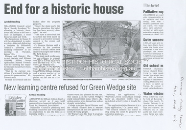
Newspaper clipping (photocopy/digital only): End for a historic house, Lyndal Reading, Diamond Valley Leader, February 1, 2006, p9Alistair Knox Park, Eltham, Eltham Skate Park A small cream cottage with green roof. The farmhouse built in the late 1800s by the Crozier Family. Subsequently owned by the Hill Family. Purchased in the early 1960s and by 1965 the property was owned by the Shire of Eltham. Employees of the Shire lived in the house. Susan Street originally ran all the way north of Bridge Street to the bend where it turned to the left into Brisbane Street. Today that section of Susan Street has been renamed as an extension of Brisbane Street. In 2006 the Shire of Nillumbik demolished the house which had been subject to extensive vandalism. In accordance with heritage advice and a permit condition a sign was placed on the site outlining the history of the building. This was installed and remained in place till about 2016 when it was removed. The land adjoins Alistair Knox Park. By 2010 the Eltham Skate Park was developed. In 2022 a major renovation and extension took place. Sources: EDHS Newsletter No 171 November 2006alistair knox park, eltham, eltham skate park, house, susan street -
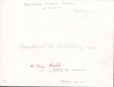 Northern District School of Nursing. Managed by Bendigo Historical Society Inc.
Photograph - Nurses hostel "McEniry"
The Northern District School of Nursing opened in 1950 in to address the issues around nurse recruitment, training and education that had previously been hospital based. The residential school was to provide theoretical and in-house education and practical training over three years. The students would also receive practical hands-on training in the wards of associated hospitals. The Northern District School of Nursing operated from Lister House, Rowan Street, Bendigo. It was the first independent school of nursing in Victoria and continued until it closed in 1989.NDSN McEniry House, Short Street Bendigo, demolished to build dining room. Photo has two names Sander's House and McEniry House, further research required.NDSN McEniry House, Short Street Bendigo, demolished to build dining room.ndsn, nursing -
 Kew Historical Society Inc
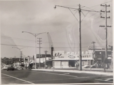
Photograph, Stuart Tompkins Studio, Electricity Supply Poles, Warrigal Road, Ashwood, 1965
Research provided by Stuart Tompkins Studio, Box Hill, into alternatives for median strip street lighting to be used in Burke Road, Kew. The photographers identified variants in different suburbs appropriate to Kew's needs.The series from which the photograph is drawn provides a snapshot by a commercial photographic studio of each named vicinity in 1965 as well as providing examples of public works infrastructure being commissioned by local government in the 1960s. The photos originally formed part of the Engineering Department's files in the City of Kew before being donated to the kew Historical Society.Electricity Supply Poles, Warrigal Road, Ashwood, 1965. Stuart Tompkins Studio provided this photograph for the Kew City Council. The photograph, taken at the intersection of Warrigal Road and High Street South, Ashwood looks north along High Street Road. The intent of the photograph was to provide the Council with models of electricity supply poles. In the photo, wooden and steel poles can be seen in the median strip. The photograph also includes the shops bordering High Street Road during this period. [There are three copies of this photograph in the Collection.]. Typed inscription on reverse: "Electricity Supply Poles. Photographed for Kew City Council 8/2/65. No.4 Warrigal Road - Ashwood. South of High Street Road looking north. Wooden and steel poles with different brackets in median strip." Studio stamp: "Stuart Tompkins Studio. 547 Station Street, Box Hill. WX1439."electric light poles, public works -- 1960s, civic infrastructure -- 1960s -
 Kew Historical Society Inc
Photograph, Stuart Tompkins Studio, Electricity Supply Poles, Warrigal Road, Ashwood, 1965
Research provided by Stuart Tompkins Studio, Box Hill, into alternatives for median strip street lighting to be used in Burke Road, Kew. The photographers identified variants in different suburbs appropriate to Kew's needs.The series from which the photograph is drawn provides a snapshot by a commercial photographic studio of each named vicinity in 1965 as well as providing examples of public works infrastructure being commissioned by local government in the 1960s. The photos originally formed part of the Engineering Department's files in the City of Kew before being donated to the kew Historical Society.Electricity Supply Poles, Warrigal Road, Ashwood, 1965. Stuart Tompkins Studio provided this photograph for the Kew City Council. The photograph, taken at the intersection of Warrigal Road and High Street South, Ashwood looks north along High Street Road. The intent of the photograph was to provide the Council with models of electricity supply poles. In the photo, wooden and steel poles can be seen in the median strip. The photograph also includes the shops bordering High Street Road during this period. [There are three copies of this photograph in the Collection.]. Typed inscription on reverse: "Electricity Supply Poles. Photographed for Kew City Council 8/2/65. No.4 Warrigal Road - Ashwood. South of High Street Road looking north. Wooden and steel poles with different brackets in median strip." Studio stamp: "Stuart Tompkins Studio. 547 Station Street, Box Hill. WX1439."electric light poles, civic infrastructure - 1960s, public works -- 1960s -
 Kew Historical Society Inc
Photograph, Stuart Tompkins Studio, Electricity Supply Poles, Warrigal Road, Ashwood, 1965
Research provided by Stuart Tompkins Studio, Box Hill, into alternatives for median strip street lighting to be used in Burke Road, Kew. The photographers identified variants in different suburbs appropriate to Kew's needs.The series from which the photograph is drawn provides a snapshot by a commercial photographic studio of each named vicinity in 1965 as well as providing examples of public works infrastructure being commissioned by local government in the 1960s. The photos originally formed part of the Engineering Department's files in the City of Kew before being donated to the kew Historical Society.Electricity Supply Poles, Warrigal Road, Ashwood, 1965. Stuart Tompkins Studio provided this photograph for the Kew City Council. The photograph, taken at the intersection of Warrigal Road and High Street South, Ashwood looks north along High Street Road. The intent of the photograph was to provide the Council with models of electricity supply poles. In the photo, wooden and steel poles can be seen in the median strip. The photograph also includes the shops bordering High Street Road during this period. [There are three copies of this photograph in the Collection.]. Typed inscription on reverse: "Electricity Supply Poles. Photographed for Kew City Council 8/2/65. No.4 Warrigal Road - Ashwood. South of High Street Road looking north. Wooden and steel poles with different brackets in median strip." Studio stamp: "Stuart Tompkins Studio. 547 Station Street, Box Hill. WX1439."electric light poles, public infrastructure -- 1960s, civic works -- 1960s -
 Eltham District Historical Society Inc
Slide, Beard Street, Eltham, Nov. 1981
Roll of film taken by Eltham Shire Council officers (Nov. 1981) of the Beard street group, a private street scheme, before construction commenced in February 1982. They provide perspective of the changes in housing styles and road development that began sweeping in from the mid 1970s with increasing urbanisation of what was once more outlying suburbs and regions.35 mm colour positive transparency (1 of 27) Mount - Kodak Ektachrome CardProcessed 18 Jan 1982beard street, eltham, housing estate, infrastructure, private street scheme, roads -
 Eltham District Historical Society Inc
Slide, Frank Street, Eltham, Nov. 1981
Roll of film taken by Eltham Shire Council officers (Nov. 1981) of the Beard street group, a private street scheme, before construction commenced in February 1982. They provide perspective of the changes in housing styles and road development that began sweeping in from the mid 1970s with increasing urbanisation of what was once more outlying suburbs and regions.35 mm colour positive transparency (1 of 27) Mount - Kodak Ektachrome CardProcessed 18 Jan 1982eltham, housing estate, infrastructure, private street scheme, roads, andrews street, frank street -
 Eltham District Historical Society Inc
Slide, Frank Street, Eltham, Nov. 1981
Roll of film taken by Eltham Shire Council officers (Nov. 1981) of the Beard street group, a private street scheme, before construction commenced in February 1982. They provide perspective of the changes in housing styles and road development that began sweeping in from the mid 1970s with increasing urbanisation of what was once more outlying suburbs and regions.35 mm colour positive transparency (1 of 27) Mount - Kodak Ektachrome CardProcessed 18 Jan 1982eltham, housing estate, infrastructure, private street scheme, roads, frank street, foster road, quentin way -
 Eltham District Historical Society Inc
Slide, Frank Street, Eltham, Nov. 1981
Roll of film taken by Eltham Shire Council officers (Nov. 1981) of the Beard street group, a private street scheme, before construction commenced in February 1982. They provide perspective of the changes in housing styles and road development that began sweeping in from the mid 1970s with increasing urbanisation of what was once more outlying suburbs and regions.35 mm colour positive transparency (1 of 27) Mount - Kodak Ektachrome CardProcessed 18 Jan 1982foster way, frank street, housing estate, infrastructure, private street scheme, roads -
 Eltham District Historical Society Inc
Slide, Frank Street, Eltham, Nov. 1981
Roll of film taken by Eltham Shire Council officers (Nov. 1981) of the Beard street group, a private street scheme, before construction commenced in February 1982. They provide perspective of the changes in housing styles and road development that began sweeping in from the mid 1970s with increasing urbanisation of what was once more outlying suburbs and regions.35 mm colour positive transparency (1 of 27) Mount - Kodak Ektachrome CardProcessed 18 Jan 1982roads, eltham woods childcare co-operative, frank street, housing estate, infrastructure, private street scheme