Showing 11140 items
matching planning
-
 Melbourne Tram Museum
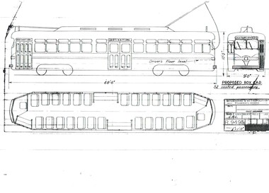
Drawing, Melbourne & Metropolitan Tramways Board (MMTB), "Proposed Box Car", Jan. 1955
Print of drawing R9495, "Proposed Box Car" - with one end and one large central door, high floor - streamliner US PCC approach. Gives side elevation and floor plan. Seats 52 passengers. Prepared 10/1/1955trams, tramways, pcc class, bogie trams, new tramcars, tramcar construction, proposals -
 Port Melbourne Historical & Preservation Society
Audio - PMHPS Meeting, Fairstar, Robert PRADOLIN and Rob JELL, Glen Stuart, 1996
Recording of PMHPS meeting on 22.01.1996. Recorded by Glen STUART at the Liardet Community Centre. Speakers were Robert PRADOLIN of Faristar and Rob JELL, consultant to Faristar. Discussing plans for HMAS Lonsdale site development. Recording duration 01:11:17built environment - commercial, faristar, sandridge lagoon, robert pradolin, rob jell -
Port Melbourne Historical & Preservation Society
Audio - Radio 3LO program excerpts, Sandridge City Development plan, 1991 - 1993
Various excerpts from 3LO radio prgrams, including Ranald McDONALD interviewing Jim KENNAN and Doug AITKEN interviewing Mark BIRRELL about Sandridge City Development (Bayside Plan) Recording duration 47:09. Approx 1991 and 1993town planning - proposals shelved - bayside, jim kennan, mark birrell, sandridge city development co pty ltd, scdc -
 Bendigo Historical Society Inc.
Document - NEW CHUM LINE OF REEF - REFERENCE TO CALEB THOMAS PLANS
Five pages of reference numbers used on Caleb Thomas plans. Has the mine's name, size of shaft and on other pages, the height of the sill. One mine on the Sheepshead Line, the New St Mungo is mentioned. Many mines along the reef are mentioned.document, gold, mines, new chum line of reef, reference to caleb thomas plans, catherine reef extd., new franklin, murchison, catherine reef united, catherine reef (south), acadia catherine, william's united, york & durham, belmont & saxby, ellenborough, sadowa, (old) st mungo, lady barkly, princess alice (sth st mungo), unicorn trib, pheonix, hopewell, united devonshire (princess alex), west united devonshire, east united devonshire, duchess of edinburgh, south devonshire, duchess tribute, new st mungo, new st mungo, new vict catherine, gt extd vict, herc new chum (late pearl), pearl south, north herc & energetic, herc & energetic, ironbark, vict consols, south new chum, lansell's 616, south belle vue, eureka extd, new chum rly, south old chum, new chum consolidated, ellesmere (south shaft), garibaldi, cravens, young chum, ellesmere nth shaft, new chum united, new chum vic, old chum, lazarus, cent new chum, lansell's 222, north old chum, lansell's big 180, advents advance, gt cent vict, hamboldt, ballerstedt, victoria quartz, herc & energetic, herc (old), shenandoah, victoria reef gold, victoria consols -
 Bendigo Historical Society Inc.
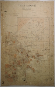
Map - NEILBOROUGH, 6/12/1882
Map: Parish of Neilborough, County of Bendigo. Parish plan. J A Morrison Junior June 1877. Examined by ? Harvey 21/8/1877. Additions made by J V Walshe24/10/82. Examined by E D 39/10/82.map, bendigo, parish plan, neilborough, j a morrison jr., harvey, j v walshe -
 Bendigo Historical Society Inc.
Map - FORTUNA HUSTLER'S MINE - PLAN OF THE FORTUNA HUSTLER'S MINE
Plan of the Fortuna Hustler's Mine, Bulletin No 33, Plate No II. Geological Survey of Victoria. Signed by H A Whitelaw, Underground Survey Office Bendigo, September 1913. Map shows levels and depths. There are smaller drawings of some sections of some levels. mining, parish map, fortuna hustler's mine, plan of the fortuna hustler's mine, geological survey of victoria, h a whitelaw, underground survey office bendigo -
 Lakes Entrance Historical Society
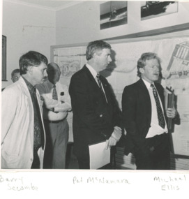
Photograph - Tambo Shire Councillors 1991, 1991
Black and white photograph showing Barry Secombe and Michael Ellis of Tambo Shire with Pat McNamara National Party State Leader during presentation of plans for new project taken at Tambo Shire Office Palmer Road Lakes Entrance Victoria local government -
University of Melbourne, Burnley Campus Archives
Plan, Alterations and Refurbishment of the Centennial Display Building, 1990
Specification of workmanship and materials to be used in the construction of: Alterations and Refurbishment of the Centennial Display Building at Victorian College of Agriculture and Horticulture, Burnley for VCAH by Urban Spaces Pty. Ltd., Architects. Includes Plans and Elevations, and Presentation Drawings. Provenance Geoff C(?) 19.08.91. burnley horticultural college, centennial display building, urban paces pty. ltd., architectural plans, bookshop -
Tatura Irrigation & Wartime Camps Museum
Photograph, Dhurringile Escape, 2001
Dhurringile Escape through Tunnel. Detmers; Bertram; Grotz; Jas; Kernstock; Folter; Jung; Plattfaut; Jansen; Menge; Kissel; Raasch; Eberle; Somann; Mader; Blomberg; Koch; Sommer; Rodszies; Schmidt. 2 Articles. Further references in folders: 1829- sketch of camp 13 tunnel.|800- Plan of Dhurringile with room allocation of POW's 858- Army Garrison. 1762- Intelligence Reports. Newspaper articles in top drawer of plan cabinet.detmers, bertram, grotz, jas, kernstock, folter, plattfaut, jansen, menge, kissel, raasch, eberle, somann, mader, blomberg, koch, sommer, rodszies, schmidt, room allocation -
 Greensborough Historical Society
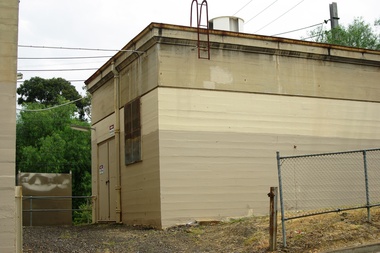
Photograph - Photograph - Digital Image, Marilyn Smith, Poulter Avenue power station - Greensborough Railway Station 2021, 2021_02
Photographs of Poulter Avenue power station at Greensborough Railway Station in February 2021, before the planned rebuild of the station as part of the Hurstbridge rail line upgrade. 4 Colour digital photographsgreensborough railway station, hurstbridge rail line upgrade, poulter avenue greensborough -
 Greensborough Historical Society
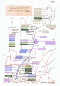
Maps, Yan Yean Water Supply System Conservation Management Plan: Construction dates Map 1, 2007_
Plan of Yan Yean Water Supply System, showing natural and constructed features from 1850s to 1930s from Silver Creek Weirs to Eastern Freeway.Printed in colour one side. 3 copieswater supply, yan yean reservoir, plenty river -
 Greensborough Historical Society
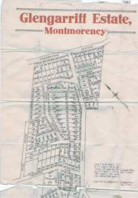
Map, Glengarriff Estate Montmorency, 1938c
Estate Agent's plan of Glengarriff Estate, Montmorency, covering LPs 11334 and 11451. Bordered by Sherbourne Avenue, Calrossie Avenue, Montmorency Station and Price AvenueColour photocopy of subdivision map, on two A3 sheets glengarriff estate montmorency, sherbourne avenue montmorency, calrossie avenue montmorency, price avenue montmorency, montmorency station -
 Greensborough Historical Society
Newspaper Clipping, Diamond Valley Leader et al, Options brought to table, 18/01/2017
A radical plan, which would see the North East Link built with fly-overs and trenches rather than tunnels, could affect Banyule residents.News article 1 page, black text.north east link, banyule, metropolitan ring road -
Tatura Irrigation & Wartime Camps Museum
Folder, Karlsruhe, 1987
History of "Karlsruhe" homestead on Nation Trust of historical homes built by Baon Von Swaine. Also plans maps, photographs. Tape of official opening 1986Black and white mottled binder, contains newspaper articles on renovation of Karlsruhekarlsruhe homestead, lancaster, baron von swaine, tatura, documents, history, local, newspapers -
Stawell Historical Society Inc
Book - Report, Grampians: A Report on recreation and Timber Uses of. Too Steep to Graze - Too Rocky to Plough, 1979
1) Conservation & Economics 2) Grampians Study Area 3) Land Use 4) Management 5) Criticisms of the Management Plan Appendix Graphs & MapsGreen Paper cover: Black tape on SpineConservation council of Victoria and Logo -
Robin Boyd Foundation
Letter, McCay & Thwaites (Barristers & Solicitors), 18.06.1958
Letter to Robin Boyd regarding 158 Riversdale Rd fence realignment. Includes a plan with area enclosed by adjoining occupier at 160 Riversdale Rd, Camberwell. -
 Kew Historical Society Inc
Plan - Subdivision Plan, Mayfield Estate, 1927
A number of the plans in the Kew Historical Society’s collection can also be found in other collections, such as those of the State Library of Victoria. A number are however unique to the collection.The Kew Historical Society collection includes almost 100 subdivision plans pertaining to suburbs of the City of Melbourne. Most of these are of Kew, Kew East or Studley Park, although a smaller number are plans of Camberwell, Deepdene, Balwyn and Hawthorn. It is believed that the majority of the plans were gifted to the Society by persons connected with the real estate firm - J. R. Mathers and McMillan, 136 Cotham Road, Kew. The Plans in the collection are rarely in pristine form, being working plans on which the agent would write notes and record lots sold and the prices of these. The subdivision plans are historically significant examples of the growth of urban Melbourne from the beginning of the 20th Century up until the 1980s. A number of the plans are double-sided and often include a photograph on the reverse. A number of the latter are by noted photographers such as J.E. Barnes.The Mayfield Estate subdivision included 14 allotments surrounding Evan Court (now Evans Court) in Toorak. The subdivision adjoined Toorak Road east of Kooyong Road and alerted prospective buyers to how the Toorak Road tram would take them directly to the city. This emphasis on existing transport routes was a feature of subdivisions during a period when car ownership was the preserve of the wealthy. An existing brick villa (‘Mayfield’) is noted as already constructed on lot 13. The subdivision also notes that the lots adjoin land owned by Sir Edward Miller. Today Evans Court extends beyond this subdivision through to Moonga Road.subdivision plans - toorak, mayfield estate, sir edward miller -
 Melbourne Legacy
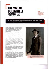
Article, The Vivian Bulwinkel Memorial, 2022
An article in Mufti magazine about Vivian Bulwinkel and a planned memorial to her at the AWM. The wellness centre opened in Legacy House in 2021 is named in her honour.The article mentions the Legacy/RSL Veterans Hub at Legacy House.Colour photocopy x 4 pages of an article in Mufti Vol 62 April 2022 about Vivian Bulwinkel.vivian bullwinkel, memorial -
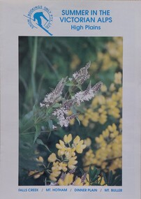 Falls Creek Historical Society
Booklet - Summer in the Victorian Alps - High Plains
Part of an annual marketing campaign, this booklet was designed to provide information for planning a summer holiday in the High Country of Victoria, including booking information and contact details.This item is important as it documents seasonal activities at Falls Creek Alpine Area and the High Plains. An A4 sized marketing booklet, including images and advertising information printed on glossy paper.On front: Summer in the Victorian Alps - High Plains FALLS CREEK / MT. HOTHAM / DINNER PLAIN / MT. BULLERhigh country marketing, victorian alps -
 City of Kingston
Pamphlet - Colour, S. M. Reynolds, Estate Agent, Moorabbin Shire Hall Estate Second Section, c. 1930
Sales plan for land in the suburb of Moorabbin, bounded by South Road and Highbury Street, including Prince Street, Charming Street, Thomas Avenue and Keith Road.The developing urban area of Moorabbin within the City of Kingston. This land sale pamphlet illustrates the subdivision of land within the municipality and the changing demographic of the district as new houses are constructed close to infrastructure.Colour pamphlet advertising for private sale the Moorabbin Shire Hall Estate, Moorabbin. Incorporates a map of the estate bordered by South Road and Highbury Street, including Prince Street, Charming Street, Keith Road and Thomas Avenue.Handwritten in grey pencil on subdivision map below subdivision 63: £4 Handwritten in grey pencil on subdivision map below subdivision 66: 4 Handwritten in grey pencil on subdivision map below subdivision 80: 3. Handwritten in grey pencil on subdivision map below subdivision 81: 4 Handwritten in grey pencil on subdivision map below subdivision 83: 2 Handwritten in grey pencil on subdivision map below subdivision 96: £3 Handwritten in grey pencil on subdivision map below subdivision 97: 3 Handwritten in grey pencil on subdivision map to the left of subdivision 102: 3 Handwritten in grey pencil on subdivision map on the corner of Thomas Avenue and Highbury Street: vertical line next to a square with a cross in it.land sales, estate, moorabbin -
 Whitehorse Historical Society Inc.
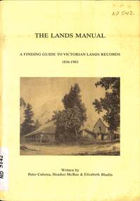
Manual - Government (Lands Dept), Royal Historical Society of Victoria, The Lands Manual - A Finding Guide to Victorian Land Records 1836 - 1983, March 1989
The manual documents the archives of the Department of Crown Lands and Survey (Lands Department) between 1836 to 1983 and explains how they can be used for historical research.The manual documents the archives of the Department of Crown Lands and Survey (Lands Department) and explains how they can be used for historical research.The manual documents the archives of the Department of Crown Lands and Survey (Lands Department) between 1836 to 1983 and explains how they can be used for historical research.crown lands, victoria. department of crown lands and survey -
 Hymettus Cottage & Garden Ballarat
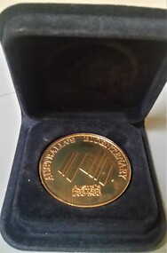
Medal - Medallion, Western Victorian Games Australian Bicentenary medal
Australian Bi-Centennial medal issued for the Western Victorian Games 1988, the only time these games were undertaken despite initial plans to be a regular event.Held in 1988 the Western Victorian Games were a Bi-Centennial project of the Victorian Government proposed to be held every four years but never repeated after 1988.circular medallionAustralian Bi-Centenniarymedal, sport, westerrn victorian games -
 Greensborough Historical Society
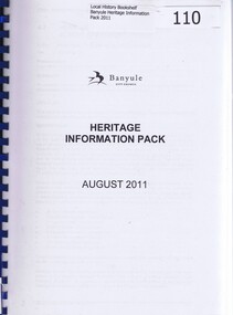
Book, Heritage Information Pack August 2011, 2011_08
This is an updated draft of Banyule City Council's "Heritage Policy and Plan". Its purpose is "To give strategic direction for improved understanding, protection and promotion of Banyule's heritage"This document lists sites in the City of Banyule assessed for their heritage value.261 pages plus appendices. Photocopied A4 book on white paper with red pages interleaved. Blue spiral binding, clear front cover and brown card back cover.bnayule city council, banyule heritage review -
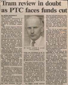 Melbourne Tram Museum
Newspaper, The Age, "Tram review in doubt as PTC faces funds cut", "Tramway plan offers reform at a price", "Report criticises run-down trams", 1992
.1 - Newspaper clipping, The Age 3/8/1992, titled "Tram review in doubt as PTC faces funds cut", written by Jacqui Macdonald Transport Reporter, with a photo of Mr Spyker, Transport Minister. Quotes Mr John McMillan, DG of Transport, re issues of getting cabinet support for planned upgrades, storage of W class trams, unions, conductors, work practices, cross linking of tram routes, rail and buses. .2 - Editorial, The Age, 2/7/1992 - titled "Tramway plan offers reform at a price" - about the proposed plan to restructure the public transport system, W class trams, operations and the revolt against scratch tickets. .3 - Newspaper clipping - The Age - 3/4/1992 titled "Report criticises run-down trams" abort the report by Workshops director John Barry, the condition of W class trams, stored B class trams, sub-stations and maintenance.trams, tramways, budgets, ptc, unions, w class, b class, public transport, funding, operations, scratch tickets -
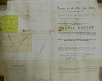 Bendigo Historical Society Inc.
Document - MARKS COLLECTION: BOUNDY'S FREEHOLD GOLD MINES MALMSBURY
Plan/advertisement 1888 for the sale of the Boundy's Freehold Gold Mines Malmsbury, 260 acres of auriferous and arable freehold land. Document contains map of mines, names include O'Connors Freehold Company, Egyptian Company, Queen's Birthday Company, No.1 South Queen Company, Madam O'Connor's company, Extended South Queen's Birthday Company. Scale 10 chains to one inch. Taken from Mr. H. Archdale's Plan by Walter Sleeman, Mining Mgr., Oct 9th. 1888. On RH side of map Daylesford Road to Malmsbury marked. The land is only about two miles from the Malmsbury railway station. On back of document letter from Henry Nutman, Mining Manager, Queens Birthday Company; Report on Plan Walter Skleeman, M.M.; letter to S. Deeble, 35 Queen St., Melbourne with report on mine from George Jenkyn and Mining Manager's Report in Argus 24th.October 1888.mine, gold, boundy's freehold gold mine -
 Eltham District Historical Society Inc
Document - Sales Brochure, Dallas Price Homes Pty Ltd, Eltham Hub: A Unique New Entry To Eltham's Town Centre; the facts about this multi purpose development, 1996
Produced by Contour Consultants Australia Pty Ltd on behalf of Dallas Price Homes Pty Ltd as part of the planning process for redevelopment of the former Eltham Shire Office site at 895 Main Road. In 1963 the Shire of Eltham purchased the Shillinglaw property of approximately 2 acres in Main Road, Eltham for the widening of Main Road and as a site for new Council offices. This land, which contained the Shillinglaw Cottage (c1878-80), was the remaining section of the Shillinglaw family holding that originally comprised 30 acres, being Lot 90 of Holloway's 1851 subdivision. Eltham Council intended to demolish this cottage, but through extensive community action it was saved, funds were raised, and it was relocated to the current site adjacent to the Eltham Library. The new Eltham Shire Offices opened in 1965 were designed to ensure retention of the three Italian Cypress trees that were located outside the Shillinglaw Cottage. In 1971 the building was extended at the southern end to provide additional space, including for the Eltham Library and Council's Engineering Department. Renovations were undertaken to the offices during 1987. The Victorian State Government commenced to restructure local government in 1994, which resulted in the establishment of the Shire of Nillumbik and the cessation of the Shire of Eltham. This new Nillumbik Shire Council was headed by government appointed commissioners, who decided in 1995 to put the former Eltham Shire offices on the market. Eventually in June 1996 the property was sold for $1.1 million and the building was subsequently demolished. A planning application for the site was then submitted to Nillumbik Shire Council in September 1996 for construction of a 24-hour service station, convenience store, cafe/takeaway food premises, a retail facility and community facility. There were many objections to this proposed development and in controversial circumstances a planning permit was granted by the Nillumbik Shire Council commissioners. After protracted actions involving a planning panel and a planning advisory committee, established by the Minister for Local Government, the proposal was eventually rejected as not satisfying the requirements of the planning scheme. In December 1997 the purchaser withdrew from the contract of sale, just prior to Council announcing a withdrawal from the contract. While there have been a number of possible development proposals considered by subsequent Nillumbik Shire Councils, this site has remained vacant since July 1996. TIMELINE (Prepared by Jim Connor, Eltham District Historical Society- March 2018- Based on press, council and personal records) June 1996 - Eltham Shire offices sold to Dallas Price Homes for $1.1 million. July 1996 - Shire office building demolished against community's wishes. Council claimed building riddled with asbestos. September 1996 - Planning application submitted to Nillumbik Shire Council to construct on the site a 24 hours Shell service station, convenience store, Hungry Jacks café/takeaway food premises, a retail facility and community facility. 213 objections and petition of over 1400 signatures received. Minister for Planning and Local Government orders an independent investigation into valuation and sale. 9 October 1996 - Permit granted by Nillumbik Shire Council commissioners, in controversial circumstances. A Planning Special Committee consisting of 3 commissioners and 3 community representatives considered 32 community objections. One commissioner declared a potential conflict of interest so only 2 commissioners were able to vote. After hearing all objections, the community representatives moved a foreshadowed motion to refuse a permit. The commissioners then closed the meeting, formerly opened a council meeting (for about a minute) and approved the application. October 1996 - Community members appealed planning decision to Administrative Appeals Tribunal. November 1996 -Minister for Planning and Local Government Robert McClelland calls appeal in and directs MT to refer this 'major policy issue' to the Governor in Council. February 1997 - Planning panel (Dimity Reed and Margaret Pitt) established to consider submissions. March 1997 - New council elected with five councillors. April 1997 - Three of the five new councillors vote to fight Commissioner's decision to grant a permit. April 1997 - Planning panel (Dimity Reed and Margaret Pitt) conducts hearings at Nillumbik Shire offices. June 1997 -Planning panel rejected Dallas Price Homes proposal as being 'totally inappropriate' for the site and recommends the site be rezoned for 'public purposes'. July 1997 - Dallas Price Homes threatened to sue Council and individual councillors. October 1997 - Report released of an Advisory Committee (Paul Jerome) established by the Minister for Planning and Local Government. Committee considered Dallas Price Homes proposal and an alternative concept plan proposal by Council for a gallery, workshop, offices and cinema community-based development. Advisory Committee recommended Dallas Price Homes proposal be rejected as not satisfying the requirements of the planning scheme and recommended further testing of the financial viability of Council's proposal. December 1997 - Dallas Price Homes withdrew from the contract of sale, just prior to Council announcing a withdrawal from the contract, which expired on 28th November and was not renewed by either side, after previously being extended twice pending a decision by the Minister. Council had to pay developer $58,000 for demolition costs. February 1998 - Dallas Price Homes application rejected by Planning and Local Government Minister. October 1998 - Nillumbik Councillors suspended and an Administrator appointed (until March 1999). The demolition of the former Shire of Eltham offices and proposed sale and development driven by the Commissioners for Nillumbik Shire Council brought the community together in substantial protest at the infrigement of ratepayers democratic say in local government and ciommunity assets combined with protests about inappropraite development of Eltham's Gateway. This issue led to the formation of the Eltham Community Action Group which still operates strongly today (2023) on behalf of the community to ensure appropriate development within the community.895 main road, commissioners, dallas price homes, development application, eltham hub, hungry jacks, nillumbik shire council, re-zoning, shell service station, town planning, eltham gateway, eltham gateway action group, eltham shire offices, shillinglaw cottage, shillinglaw farm, shillinglaw trees, jim connor collection -
 Melbourne Legacy
Document - Document, letter, Re: Blamey House
Carbon copy of a letter from Legatee H.L. Berg dated 4th October 1974 to A.Quayle, Esq., Chairman of the Housing Steering Committee in which Legatee Berg confirms the completion of the Stage Two design for Blamey House. The plan was to be submitted to the Board of Management. Costs of $170,000 were estimated and the plans would also have to be submitted to Kew Council, which Legatee Berg undertook to do. See also Cat. No. 01696. In a file with documents pertaining to the residences. An example of the detailed work Melbourne Legacy did to house Junior Legatees.1 x carbon copy, black on white. Two holes punched for filing. residences, blamey house -
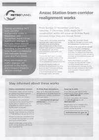 Melbourne Tram Museum
Pamphlet - Metro Tunnel - Anzac Station tram corridor works, Rail Projects Victoria, 11/2022
Provides information about the works planned to realign tram tracks at the Metro Tunnel Anzac station, following the completion of the surface works. Gives timing, tram routes affected, plans of the proposals, contact details. All St Kilda Road routes would be affected from 27/11/2022 to 17/12/2022, tram stops would be closed, bus replacement services. includes works to remove the Glenhuntly Road level crossing at Glenhuntly Station. Yields information about the trackworks for the future Anzac Station interchange and St Kilda Road services.Set of two documents issued by Rail Projects Victoria (Metro Tunnel) and Yarra Trams with regard to the reallignment of tram tracks at Anzac Station Nov. 2022 1 - Metro Tunnel - Works proposed, maps - 6 A4 pages 2 - Yarra Trams - Service Changes St Kilda Road works - 4 A4 pages.anzac station, metro tunnel, tramways, st kilda road, domain road, domain interchange, park street, track work, tram tracks, glenhuntly road, glenhuntly station, level crossings -
 Ringwood and District Historical Society
Document - Property Titles, Transfer of Land Act - "Pinemont", Ringwood, Victoria
Folder containing copies of LANDATA documents relating to "Pinemont", Panorama Avenue, Ringwood, Victoria, compiled for potential real estate sales background information purposes. Title Vol 965 Fol 923 Allotment 27B Parish of Warrandyte - James Forbes, dated 30th August, 1876. Title Vol 5236 Fol 1947157 Lots 294 and 370 on Plan of Subdivision no.11392 - Anthony Loughnan, dated 4th March, 1927. Title Vol 6415 Fol 1282937 Lot 294 on Plan of Subdivision no.11392 - Jessie McCracken Rothwell Woodard, dated 9th September, 1940. -
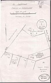 Bendigo Historical Society Inc.
Document - HARRY BIGGS COLLECTION: EAGLEHAWK LOGS APPEAL, (1 -3) 4/11/70 (3)26/2/69
Document. Harry Biggs Collection. Item 1 - An account of a meeting held in Council Chambers on 4th Nov. 1970 regarding Eaglehawk Log Lock-up on blue paper. Handwritten. Item 2 - Typed minutes on white paper Of meeting of Eaglehawk Log Lock-up committee held in Mayor's room Town Hall, Eaglehawk on 27th Aug. 1970. Item 3 - Plan of At Eaglehawk Parish of Sandhurst. Plan E 26.2.69 (reviews 22.10.69). Item 3 - 15 typed copies of the history & description of Eaglehawk Log Lock-up, also includes the cost of moving & restoring it.place, building, site, harry biggs collection, log lock-up, eaglehawk