Showing 41895 items
matching were
-
 Clunes Museum
Sign - DISPLAY PANEL, 2000
COPIES OF DISPLAY PANELS DONATED TO THE PEOPLE OF CLUNES BY THE HUGH WILLIAMSON FOUNDATION.INTERPRETIVE DISPLAY PANEL DEPICTING HISTORY OF SCHOOL DAYS IN CLUNES. WOODEN DISPLAY PANEL AND LAMINATED COPY.SCHOOL DAYS CHILDREN OF EARLY GOLDFIELD TOWNS WERE TAUGHT IN TENT SCHOOLS.THESE SCHOOLS WERE EASILY MOVED TO THE SITE OF THE LATEST GOLDRUSH. WITH GREATER COMMUNITY STABILITY PERMANENT SCHOOLS WERE ESTABLISHED. CLUNES STATE SCHOOL NO. 1552 WAS OPENED IN JULY 1875 ON LAND DONATED BY RIVETT H. BLAND, MANAGER OF THE PORT PHILIP GOLD MINING CO. SHORTLY BEFORE WORLD WAR ONE, THIS SCHOOL BECAME VICTORIA,S THIRD HIGHER ELEMENTARY SCHOOL. TODAY IT IS STILL USED TO EDUCATE THE CHILDREN OF CLUNES STATE SCHOOL NO. 136 WAS BUILT IN 1881 ON THE SITE OF AN EARLIER TEMPORARY SCHOOL THAT WAS BUILT IN 1857. THE DESIGN WAS FIRST USED AT HORSHAM. AND INCLUDES AN EARLY EXAMPLE OF A LARGE SCHOOL VERANDAH. IN 1892 THIS SCHOOL AMALGAMATED WITH STATE SCHOOL NO. 1552 AND WAS USED AS THE INFANT SCHOOL. IT CLOSED ITS DOORS IN 1922 AND WAS LATER USED AS A MILL FOR THE CLUNES KNITTING AND MAUFACTURING CO. LTD. IT NOW HOUSES THE CLUNES BOTTLE MUSEUM THE CLUNES CATHOLIC SCHOOL OPENED IN 1875 AND CLOSED IN 1926 THE LATEST EDUCATIONAL ASSET AT CLUNES IS A CAMPUS OF WESLEY COLLEGE. BLENDINGHISTORIC BUILDINGS AND MODERN ARCHITECTURE THE CAMPUS IS SITUATED IN SERVICE STREETlocal history, civic momentoes, presentations, williamson, hugh foundation -
 Kew Historical Society Inc
Plan - Subdivision Plan, Jas R Mathers Son & McMillan, East Kew Tramway Estate, 1915
Pru Sanderson, in her groundbreaking ‘City of Kew Urban Conservation Study : Volume 2 - Development History’ (1988), summarised the periods of urban development and subdivisions of land in Kew. The periods that she identified included 1845-1880, 1880-1893, 1893-1921, 1921-1933, 1933-1943, and Post-War Development. These periods were selected as they represented periods of rapid growth or decline in urban development. An obvious starting point for Sanderson’s groupings involved population growth and the associated economic cycles. These cycles also highlighted urban expansion onto land that was predominantly rural, although in other cases it represented the decline and breakup of large estates. A number of the plans in the Kew Historical Society’s collection can also be found in other collections, such as those of the State Library of Victoria and the Boroondara Library Service. A number are however unique to the collection.The Kew Historical Society collection includes almost 100 subdivision plans pertaining to suburbs of the City of Melbourne. Most of these are of Kew, Kew East or Studley Park, although a smaller number are plans of Camberwell, Deepdene, Balwyn and Hawthorn. It is believed that the majority of the plans were gifted to the Society by persons connected with the real estate firm - J. R. Mathers and McMillan, 136 Cotham Road, Kew. The Plans in the collection are rarely in pristine form, being working plans on which the agent would write notes and record lots sold and the prices of these. The subdivision plans are historically significant examples of the growth of urban Melbourne from the beginning of the 20th Century up until the 1980s. A number of the plans are double-sided and often include a photograph on the reverse. A number of the latter are by noted photographers such as J.E. Barnes.The East Kew Tramway Estate was a subdivision of two separate parcels of land between Adeney Avenue and Normanby Road. The larger section included 54 lots facing Adeney Avenue, Argyle Road, and Campbell, Hunter and Wishart Streets. [Hunter and Wishart Streets were created as part of the subdivision.] A further 17 allotments faced Normanby Road, Hubert and Campbell Streets. [The name of Hubert Street was later to be changed to Cecil Street.] The promotion of the sale referred to the advantages of living between two tram routes, in High Street and Cotham Road. On the plan, quaintly drawn trams mark these routes. Also on the plan is the route of part of the Outer Circle [Railway] Line.east kew tramway estate, subdivision plans - east kew -
 Flagstaff Hill Maritime Museum and Village
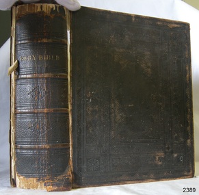
Book - Religious Book, Oxford University Press, The Holy Bible, 1866
This King James version of the Holy Bible, with Old and New Testaments, was published in 1866 in London. The large Bible contains family records of Joseph Bell (born 9-5-1829) and Elizabeth Bell (born 22-101833). Joseph and Elizabeth Bell were married on 12-09-1854 in St Paul's church, in Bristol, England. The loose endpaper within the Bible is headed 'Singleton, 2nd day of 1st month 1869" It records their marriage and the birth of their ten children. between 1856 and 1878. It appears that the entries up until their 8th child were written at the same time, 2nd January 1869, with the last two entries for children number 9 and 10, written at a later date. This fits with the Bible being published in 1866. The children were Thomas, Mary, James, John, Ruth, Andrew, Joseph, Elizabeth, Lewis and Hannah. Further research is being carried out to connect this branch of the Bell family with local history.The Holy Bible is significant for being published over 150 years ago when printed books were very expensive. The book contains handwritten records of the Bell family of Bristol and is a significant source of the Bell family history. Book, black hard cover with embossed pattern and gold test, metal locking clasp. King James Version of the Holy Bible, containing the Old and New Testaments. It was published by Oxford University Press in 1866. Inscriptions on the loose endpaper list the marriage of Joseph and Elizabeth Bell in 1854 at St Paul's, Bristol, England, and their ten children born from 1856 to 1878.Spine: "HOLY BIBLE" Fly: "THE HOLY BIBLE CONTAINING THE OLD AND NEW TESTAMENTS: TRANSLATED OUT OF THE ORIGINAL TONGUES:: AND WITH THE FORMER TRANSLATIONS DILIGENTLY COMPARED AND REVISED, BY HIS MAJESTY'S SPECIAL COMMAND" "APPOINTED TO BE READ IN CHURCHES" "OXFORD: PRINTED AT THE UNIVERSITY PRESS FOR THE BRITISH AND FOREIGN BIBLE SOCIETY, INSTITUTED IN LONDON IN THE YEAR 1804." "SOLD TO SUBSCRIBERS AT THE SOCIETY'S HOUSE, EARL STREET, BLACKFRIARS, LONDON." "MDCCCLXVI" (converts from Roman Numerals to the number 1866) LOGO with a motto: [shield with scroll, three crowns and test] "dominus illuminatio mea" (Latin, translates to "The Lord is My Light") On endpapers: Heading in script: "Singleton 2nd day of 1st month 1869" and listed below " Joseph Bell, born 9/5/1829 married Elizabeth Bell, born 22/10/1833 on 12/9/1854 at St Pauls, Bristol, England." (Numbered 1 to 10, their children and their birth dates, from 1856 to 1878, are also listed. The children were Thomas, Mary, James, John, Ruth, Andrew, Joseph, Elizabeth, Lewis and Hannah.) flagstaff hill, flagstaff hill maritime museum and village, warrnambool, maritime museum, maritime village, great ocean road, shipwreck coast, holy bible, book, religious book, bell family, bell family bible, elizabeth bell, joseph bell, 1826, 1833, 1854, st paul's bristol -
 Bendigo Military Museum
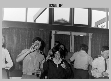
Photograph - Bones Day - Army Survey Regiment Versus RAAF School of Radio, Laverton, c1970s
These seven photographs were taken at Bones Day, an annual sports competition between the Army Survey Regiment and the RAAF School of Radio c1970s. The two units took turns each year to host the event and on this occasion was held at the RAAF School of Radio, Laverton. The day competition usually comprised basketball, cross country, golf, sailing, squash, softball, tennis, touch football, rifle shooting, tug-of-war and volleyball. The “big bone” trophy comprising a large bone from a beast housed inside a wooden framed glass case, was awarded to the winner of the day competition. The evening competition often included darts, carpet bowls, hookey, quoits and billiards/snooker. The “little bone” (a mounted chicken bone) was the consolation trophy awarded to the winner of the evening competition. The 3-hour bus trip for the visiting unit on their return was typically very raucous. The history of the Bones Day competition is best described in the booklet titled - Bones of Contention Souvenir Program. 1965. Refer to Item 6267.These seven photographs were taken at Bones Day, an annual sports competition between the Army Survey Regiment and the RAAF School of Radio at Laverton, Victoria c1970s. The photographs are on 35mm negative film. They are part of the Army Survey Regiment’s Collection. The photographic negatives were scanned at 96 dpi. There are additional photos taken at the time that have not been scanned. .1) - Photo, black & white, c1970s, L to R: Unknown, Heather Slater and unidentified RAAF personnel. .2) & .3) - Photo, black & white, c1970s, Bill Friswell playing snooker. .4) & .5) - Photo, black & white, c1970s, Bus trip back to Bendigo. Gordon Lowery, unidentified personnel. .6) - Photo, black & white, c1970s, Bus trip back to Bendigo. L to R: Peter Tieman (asleep), Phil Batchelder (Batchelor?), background Bill Friswell (at rear), Steve Gloster, Gordon Lowery (standing), Graham Bradtke, Andy Covington, Greg Towne, TJ Wicker, Roger Pearson (asleep), unidentified personnel. .7) - Photo, black & white, c1970s, Bus trip back to Bendigo. L to R: Peter Tieman (asleep), Phil Batchelder (Batchelor?), background Bill Friswell (at rear), Gordon Lowery (standing), Graham Bradtke, Greg Towne, TJ Wicker, Roger Pearson (asleep), unidentified personnel.1P to .7P – No personnel are identified.royal australian survey corps, army svy regt, rasvy, army survey regiment, raaf school of radio, asr, bones day -
 Bendigo Military Museum
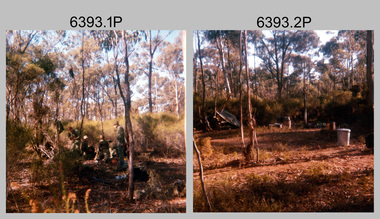
Photograph - Army Survey Regiment - Regimental Training, 1986
This is a set of 32 photographs of the Army Survey Regiment personnel undertaking military skills revision at Fortuna Villa, Bendigo (photos .29P to .32P) and most likely the Wellsford Forest in 1986. It is evident in the photo set they participated in lessons on the handling of the M30 Grenade and SLR Rifle at Fortuna before the field exercise. Other military skills such as first aid, navigation minor infantry tactics were probably included in the training.This is a set of 32 photographs of the Army Survey Regiment undertaking Regimental Training at Wellsford Forest and Fortuna Villa in 1986. The photographs were printed on photographic paper and are part of the Army Survey Regiment’s Collection. The photographs were scanned at 300 dpi. .1) - Photo, colour, 1986. Unidentified soldiers preparing their meal. .2) - Photo, colour, 1986. Hootchie accommodation. .3) - Photo, colour, 1986. Hootchie accommodation L to R: CPL Roger Pearson and unidentified soldier. .4) & .5) - Photo, colour, 1986. Unidentified personnel enjoying bush cricket. .6) - Photo, colour, 1986. Unidentified soldier with SLR rifle. .7) - Photo, colour, 1986. Unidentified soldiers enjoying a tea break. .8) - Photo, colour, 1986. Unidentified soldier on the shovel. .9) - Photo, colour, 1986. Unidentified soldiers preparing their meal. .10) - Photo, colour, 1986. Hootchie accommodation. .11) & .12) - Photo, colour, 1986. Unidentified soldiers undertaking training. .13) - Photo, colour, 1986. Hootchie accommodation, unidentified soldiers. .14) - Photo, colour, 1986. Unidentified soldier struggles to set-up their stretcher. .15) - Photo, colour, 1986, Unidentified soldier struggles to set-up their hootchie. .16) - Photo, colour, 1986. Unidentified soldiers undertaking training. .17) - Photo, colour, 1986. Hootchie accommodation. .18) - Photo, colour, 1986. SPR Dave Lawler takes a break. .19) & .20) - Photo, colour. 1986. Unidentified soldier tickles an echidna’s tummy. .21)- Photo, colour, 1986. Ablutions set-up. .22) & .23) - Photo, colour, 1986. Unidentified soldier’s hootchie accommodation. .24) - Photo, colour, 1986. Unidentified soldiers undertaking training. .25) to .28) - Photo, colour, 1986. Unidentified soldiers undertaking grenade training. .29) - Photo, colour, 1986. Unidentified soldiers taking a break from training at Fortuna. .30) to .32) - Photo, colour, 1986. Unidentified soldiers undertaking training at Fortuna..1P to .32P No personnel are identified. Some photographs are annotated ‘Regt Training 1986’royal australian survey corps, rasvy, army survey regiment, army svy regt, fortuna, asr -
 Wodonga & District Historical Society Inc
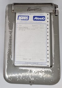
Functional object - Business Docket Dispenser, Lamson Paragon, c1960s
J. Mann and Sons was first established as a farm produce store in 1921. The range of products was extended in the 1930s and included groceries and hardware, as well as the first petrol bowser in Wodonga outside the store. After WWII, the premises were extended and the range of products continued to increase. In the 1960s the Mann Family opened a new supermarket in Wodonga, in addition to the hardware business, providing steel, plumbing and industrial supplies, and they employed over 100 people at one stage. With changes in the retail industry, the Mann Family sold the main hardware business to Bunnings and the steel and rural produce business to the Kelly brothers in 2006. Paragon, trading at various times as Lancom Paragon, Moore Paragon, Paragon Printing and the South Pacific Print Group, was also based in Wodonga from 1958 until 2010. It began as Lamson Paragon in 1958 but was destroyed by a fire causing £150,000 damage. The factory resumed operations on 24 June 1959.with 30 staff and by 1973 employed 120 and used 80 tons of paper per week. Further develp[ment took place to the factory in 2 stages. In 1977 Moore Corporation of Toronto took over control of the London based parent company Lamson Paragon necessitating a change of name of the Australian company to become Moore Business Systems Australia Limited. After many successful years of operation including expansion to a staff of 240 people, changes to business operations and the loss of several large contracts led to the company entering voluntary administration in March 2010.This machine and docket has local provenance as it came from the 20th century business of J. Mann & Son in Wodonga..The machine was manufactured by Paragon, also operating as Lamcon Paragon and Moore Paragon, which were a major manufacturer in Wodonga from 1958 until 2010.This is a grey rectangular-shaped metal box with rounded edges. The box has four metal studs on the base to keep the box stable. The box has a hinged section to enable paper dockets to be inserted. It also has a turning mechanism for removing the dockets, one at a time from a slot at the top of the machine. The machine includes a docket from Mann Mitre 10 Wodonga operated by J. Mann & Son Pty. Ltd. The dockets provided a duplicate copy for the company as well as the white copy for the customer. The dispenser and dockets were produced by Paragon.At top of dispenser: "Paragon" Across top of docket: "J. MANN & SON Pty. Ltd. (Incorporated in Victoria) TRADING AS: / Manns Mitre 10/ P.O. BOX 141, VIC., 3690. Phone: (060) 24 4813paragon, lamson paragon, moore paragon, mann wodonga, moore business systems australia limited -
 Kew Historical Society Inc
Plan, Melbourne & Metropolitan Board of Works. Borough of Kew Detail Plan No.1579, 1904
The Melbourne and Metropolitan Board of Works (MMBW) plans were produced from the 1890s to the 1950s. They were crucial to the design and development of Melbourne's sewerage and drainage system. The plans, at a scale of 40 feet to 1 inch (1:480), provide a detailed historical record of Melbourne streetscapes and environmental features. Each plan covers one or two street blocks (roughly six streets), showing details of buildings, including garden layouts and ownership boundaries, and features such as laneways, drains, bridges, parks, municipal boundaries and other prominent landmarks as they existed at the time each plan was produced. (Source: State Library of Victoria). This plan forms part of a large group of MMBW plans and maps that was donated to the Society by the Mr Poulter, City Engineer of the City of Kew in 1989. Within this collection, thirty-five hand-coloured plans, backed with linen, are of statewide significance as they include annotations that provide details of construction materials used in buildings in the first decade of the 20th century as well as additional information about land ownership and usage. The copies in the Public Record Office Victoria and the State Library of Victoria are monochrome versions which do not denote building materials so that the maps in this collection are invaluable and unique tools for researchers and heritage consultants. A number of the plans are not held in the collection of the State Library of Victoria so they have the additional attribute of rarity.Original survey plan, issued by the MMBW to a contractor with responsibility for constructing sewers in the area identified on the plan within the Borough of Kew. The plan was at some stage hand-coloured, possibly by the contractor, but more likely by officers working in the Engineering Department of the Borough and later Town, then City of Kew. The hand-coloured sections of buildings on the plan were used to denote masonry or brick constructions (pink), weatherboard constructions (yellow), and public buildings (grey). While MMBW Plan No.1579 does not include many buildings, those that it does show are significant to Kew’s history. These include the ‘Kew [Railway] Station’ in Denmark Street and the ‘Recreation Hall’ and rear courts off Wellington Street. The plan shows the outline of the Recreation Hall, constructed in 1880, at the rear of which is listed a bowling green, two tennis courts, a ‘skittle alley’ and a pavilion. When the Hall was first built, the Kew Cricket Club occupied an adjacent ground, however in 1885 this was acquired by the State Government as the future location of the Kew Railway Station. The Plan also shows a single oval at Xavier College. This oval was completed in 1883. One of the current ovals conforms to this oval’s original shape and position in the school grounds.melbourne and metropolitan board of works, detail plans, maps - borough of kew, mmbw 1579, cartography -
 Kew Historical Society Inc
Plan, Melbourne & Metropolitan Board of Works / Borough of Kew, Detail Plan No.1593, 1905
The Melbourne and Metropolitan Board of Works (MMBW) plans were produced from the 1890s to the 1950s. They were crucial to the design and development of Melbourne's sewerage and drainage system. The plans, at a scale of 40 feet to 1 inch (1:480), provide a detailed historical record of Melbourne streetscapes and environmental features. Each plan covers one or two street blocks (roughly six streets), showing details of buildings, including garden layouts and ownership boundaries, and features such as laneways, drains, bridges, parks, municipal boundaries and other prominent landmarks as they existed at the time each plan was produced. (Source: State Library of Victoria)This plan forms part of a large group of MMBW plans and maps that was donated to the Society by the Mr Poulter, City Engineer of the City of Kew in 1989. Within this collection, thirty-five hand-coloured plans, backed with linen, are of statewide significance as they include annotations that provide details of construction materials used in buildings in the first decade of the 20th century as well as additional information about land ownership and usage. The copies in the Public Record Office Victoria and the State Library of Victoria are monochrome versions which do not denote building materials so that the maps in this collection are invaluable and unique tools for researchers and heritage consultants. A number of the plans are not held in the collection of the State Library of Victoria so they have the additional attribute of rarity.Original survey plan, issued by the MMBW to a contractor with responsibility for constructing sewers in the area identified on the plan within the Borough of Kew. The plan was at some stage hand-coloured, possibly by the contractor, but more likely by officers working in the Engineering Department of the Borough and later Town, then City of Kew. The hand-coloured sections of buildings on the plan were used to denote masonry or brick constructions (pink), weatherboard constructions (yellow), and public buildings (grey). The laborious task of hand-tinting these Board of Works plans was not without hazards as is evidenced by Plan No. 1593. On the Plan, the original colourist spilt black and green ink, partially obscuring some parts. The most obvious casualty is ‘Clifton’ located on the corner of Cotham Road and Park Street [now Adeney Avenue]. Included in this Plan, and outlined in pink is that part of the section that the contracting engineer was tasked with completing. This included sewering on both sides of this part of Cotham Road, but excluded properties such as ‘Glendonald’ and ‘Monnington’. This area was to undergo a series of subdivisions including the ‘Clifton Estate’, which created housing lots on Adeney Avenue and Florence Avenue in 1916. The most notable occupant of Clifton was William Adeney [died 1893], a pioneer of Camperdown, after which Park Street was later renamed.melbourne and metropolitan board of works, detail plans, survey plans - borough of kew, mmbw 1593, cartography -
 Kew Historical Society Inc
Plan, Melbourne & Metropolitan Board of Works : Borough of Kew : Detail Plan No.1291, 1905
The Melbourne and Metropolitan Board of Works (MMBW) plans were produced from the 1890s to the 1950s. They were crucial to the design and development of Melbourne's sewerage and drainage system. The plans, at a scale of 40 feet to 1 inch (1:480), provide a detailed historical record of Melbourne streetscapes and environmental features. Each plan covers one or two street blocks (roughly six streets), showing details of buildings, including garden layouts and ownership boundaries, and features such as laneways, drains, bridges, parks, municipal boundaries and other prominent landmarks as they existed at the time each plan was produced. (Source: State Library of Victoria). This plan forms part of a large group of MMBW plans and maps that was donated to the Society by the Mr Poulter, City Engineer of the City of Kew in 1989. Within this collection, thirty-five hand-coloured plans, backed with linen, are of statewide significance as they include annotations that provide details of construction materials used in buildings in the first decade of the 20th century as well as additional information about land ownership and usage. The copies in the Public Record Office Victoria and the State Library of Victoria are monochrome versions which do not denote building materials so that the maps in this collection are invaluable and unique tools for researchers and heritage consultants. A number of the plans are not held in the collection of the State Library of Victoria so they have the additional attribute of rarity.Original survey plan, issued by the MMBW to a contractor with responsibility for constructing sewers in the area identified on the plan within the Borough of Kew. The plan was at some stage hand-coloured, possibly by the contractor, but more likely by officers working in the Engineering Department of the Borough and later Town, then City of Kew. The hand-coloured sections of buildings on the plan were used to denote masonry or brick constructions (pink), weatherboard constructions (yellow), and public buildings (grey). A detail plan of part of Studley Park bordered by the major streets of Hodgson Street, Stevenson Street and Studley Park Road. Included on the plan are a number of significant Studley Park mansions in existence at the beginning of the 20th century. The unnamed street shown in the middle of the plan is McEvoy Street. The most important house still extant is Campion House, formerly named Dalsraith [Dalswraith] and Glendalough, owned since the 1940s by the Society of Jesus. Campion House can be seen on the corner of Hodgson and Studley Park Road. Its stables at the rear of the block have now been incorporated into a contemporary residence. An interesting feature of the plan is the 1910 annotation by Ed Seitz, professional designing engineer. Is Seitz the contractor who modified the MMBW original?melbourne and metropolitan board of works, detail plans, mmbw 1291, cartography -
 Kew Historical Society Inc
Plan, Melbourne & Metropolitan Board of Works : Borough of Kew : Detail Plan No.1564, 1905
The Melbourne and Metropolitan Board of Works (MMBW) plans were produced from the 1890s to the 1950s. They were crucial to the design and development of Melbourne's sewerage and drainage system. The plans, at a scale of 40 feet to 1 inch (1:480), provide a detailed historical record of Melbourne streetscapes and environmental features. Each plan covers one or two street blocks (roughly six streets), showing details of buildings, including garden layouts and ownership boundaries, and features such as laneways, drains, bridges, parks, municipal boundaries and other prominent landmarks as they existed at the time each plan was produced. (Source: State Library of Victoria)This plan forms part of a large group of MMBW plans and maps that was donated to the Society by the Mr Poulter, City Engineer of the City of Kew in 1989. Within this collection, thirty-five hand-coloured plans, backed with linen, are of statewide significance as they include annotations that provide details of construction materials used in buildings in the first decade of the 20th century as well as additional information about land ownership and usage. The copies in the Public Record Office Victoria and the State Library of Victoria are monochrome versions which do not denote building materials so that the maps in this collection are invaluable and unique tools for researchers and heritage consultants. A number of the plans are not held in the collection of the State Library of Victoria so they have the additional attribute of rarity.Original survey plan, issued by the MMBW to a contractor with responsibility for constructing sewers in the area identified on the plan within the Borough of Kew. The plan was at some stage hand-coloured, possibly by the contractor, but more likely by officers working in the Engineering Department of the Borough and later Town, then City of Kew. The hand-coloured sections of buildings on the plan were used to denote masonry or brick constructions (pink), weatherboard constructions (yellow), and public buildings (grey). In 1905, when Plan No.1564 was printed, that part of Kew bordered by Brougham Place (now Daniell Place), Mount Street, Sackville Street and Ross Street was already the location of a number of large mansions. Here, subdivisions, at least at this stage, produced larger blocks than in Central Kew. Many of the houses on this plan are named: ‘Faybrook’, ‘Northumbria’, ‘Parkholm[e]’, ‘Dunboe’, ‘Katoomba’ and ‘Eschol’ fronting Sackville Street. Eschol was once the home of the manufacturer Robert Harrison, whose cordial factory in Spring and Argyle Streets Fitzroy are noted on the Victorian Heritage Register. ‘The Hawthorns’ on the corner of Brougham Place and Mount Street was the home of the medical practitioner Frank William Fay, who won the military cross and other honours for conspicuous gallantry and devotion to duty in World War 1.melbourne and metropolitan board of works, detail plans, mmbw 1564, cartography -
 Kew Historical Society Inc
Plan, Melbourne & Metropolitan Board of Works : Borough of Kew : Detail Plan No.1570, 1905
The Melbourne and Metropolitan Board of Works (MMBW) plans were produced from the 1890s to the 1950s. They were crucial to the design and development of Melbourne's sewerage and drainage system. The plans, at a scale of 40 feet to 1 inch (1:480), provide a detailed historical record of Melbourne streetscapes and environmental features. Each plan covers one or two street blocks (roughly six streets), showing details of buildings, including garden layouts and ownership boundaries, and features such as laneways, drains, bridges, parks, municipal boundaries and other prominent landmarks as they existed at the time each plan was produced. (Source: State Library of Victoria)This plan forms part of a large group of MMBW plans and maps that was donated to the Society by the Mr Poulter, City Engineer of the City of Kew in 1989. Within this collection, thirty-five hand-coloured plans, backed with linen, are of statewide significance as they include annotations that provide details of construction materials used in buildings in the first decade of the 20th century as well as additional information about land ownership and usage. The copies in the Public Record Office Victoria and the State Library of Victoria are monochrome versions which do not denote building materials so that the maps in this collection are invaluable and unique tools for researchers and heritage consultants. A number of the plans are not held in the collection of the State Library of Victoria so they have the additional attribute of rarity.Original survey plan, issued by the MMBW to a contractor with responsibility for constructing sewers in the area identified on the plan within the Borough of Kew. The plan was at some stage hand-coloured, possibly by the contractor, but more likely by officers working in the Engineering Department of the Borough and later Town, then City of Kew. The hand-coloured sections of buildings on the plan were used to denote masonry or brick constructions (pink), weatherboard constructions (yellow), and public buildings (grey). Plan No.1570 shows the layout of gardens and houses in Sackville Street, Davis Street, Wrixon Street, and Fitzwilliam Street in 1904. While Thomas Street is included on the map, at this stage no houses had been built. The plan identifies two named houses: ‘Fairview’ and ‘Kylemore’. Fairview is more fully delineated in Plan No.1563. Kylemore is one of the few houses in Kew designed by John Beswicke. The most notable owner of Kylemore was William Whitehead, who owned the house between 1895 and 1900. In 1894, Australian newspapers reported the marriage of Whitehead’s daughter to Dr. Gerald Eugene Cussen, the brother of Sir Leo Cussen, the Supreme Court Judge. The married couple was to live at ‘Wilton’ (now the Kew RSL) from 1911-15.melbourne and metropolitan board of works, detail plans, mmbw 1570, cartography -
 Kew Historical Society Inc
Plan, Melbourne & Metropolitan Board of Works : Borough of Kew : Detail Plan No.1572, 1905
The Melbourne and Metropolitan Board of Works (MMBW) plans were produced from the 1890s to the 1950s. They were crucial to the design and development of Melbourne's sewerage and drainage system. The plans, at a scale of 40 feet to 1 inch (1:480), provide a detailed historical record of Melbourne streetscapes and environmental features. Each plan covers one or two street blocks (roughly six streets), showing details of buildings, including garden layouts and ownership boundaries, and features such as laneways, drains, bridges, parks, municipal boundaries and other prominent landmarks as they existed at the time each plan was produced. (Source: State Library of Victoria)This plan forms part of a large group of MMBW plans and maps that was donated to the Society by the Mr Poulter, City Engineer of the City of Kew in 1989. Within this collection, thirty-five hand-coloured plans, backed with linen, are of statewide significance as they include annotations that provide details of construction materials used in buildings in the first decade of the 20th century as well as additional information about land ownership and usage. The copies in the Public Record Office Victoria and the State Library of Victoria are monochrome versions which do not denote building materials so that the maps in this collection are invaluable and unique tools for researchers and heritage consultants. A number of the plans are not held in the collection of the State Library of Victoria so they have the additional attribute of rarity.Original survey plan, issued by the MMBW to a contractor with responsibility for constructing sewers in the area identified on the plan within the Borough of Kew. The plan was at some stage hand-coloured, possibly by the contractor, but more likely by officers working in the Engineering Department of the Borough and later Town, then City of Kew. The hand-coloured sections of buildings on the plan were used to denote masonry or brick constructions (pink), weatherboard constructions (yellow), and public buildings (grey). Plan No. 1572 represents the built environment bordered by Barkers Road, Wrixon Street, Edgevale Road and Fitzwilliam Street. Other streets identified on the plan include Stansell Street. Plan 1572 shows that by 1903-05, there was only patchy development in this area of Kew, mainly on Edgevale Road and Fitzwilliam Street. Only two named houses are identified: the quaintly named ‘Tweed Cottage’, and ‘Mendip’. The earliest reference to Treed Cottage in Australian newspapers is to the death of Walter Thompson, aged 74 who was a resident there in 1885. His youngest daughter was to die there in 1908. Mendip to the north of Tweed Cottage was owned by Henry Thompson; he was to die in 1901; his wife in 1932. At this period of time, Malin Street and Clivedon Court did not extend to Barkers Road.melbourne and metropolitan board of works, detail plans, mmbw 1572, cartography -
 Phillip Island and District Historical Society Inc.
Photograph Album, Kodak, Phillip Island Cemetery, c 1990
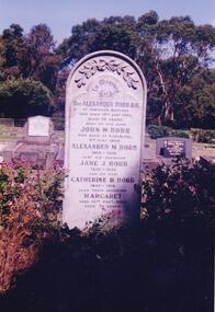
The Album was compiled by Nancy McHaffie late 1990's, with the assistance of Edith Jeffery's, with her book "Garden of Memories" and extensive knowledge of Phillip Island. The Cemetery lies back from the road and is surrounded by Manna Gums, rare Peppermint Gums, Blackwoods and other native trees. In all 25 acres of land were set aside as Crown Land in the land settlement of 1868. There are 6.2 acres of wetlands near the cemetery entrance.466-38: Rev Alexander Robb, DD. Rev Robb had been a missionary in Old Calabar and Jamaica and was the first minister of the Cowes Presbyterian Church from 1890-1901. Services were also held in the Public Hall at Rhyll. A daughter, Kathleen, like her parents, is buried in the cemetery. Kathleen was married to Harry West. 466-39: James Hill. Jimmy, as he was fondly called, came to Phillip Island in 1920 and purchased the Hotel, known as Woods Family Hotel (later the Phillip Island Hotel in Walpole Street). A milestone occurred whilst in his capable hands he installed an electric light plant, (32 volts), the first on the Island. He also made hundreds of cement bricks with which he built his own home. He died in 1937 aged 68. His only child Dorothy Edhouse aged 98, is also buried with her father.phillip island cemetery, james hill, rev alexander robb, nancy mchaffie, edith jeffery -
 Bendigo Military Museum
Photograph - Technical Tour of the Army Survey Regiment, Fortuna, Bendigo, c1984
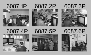
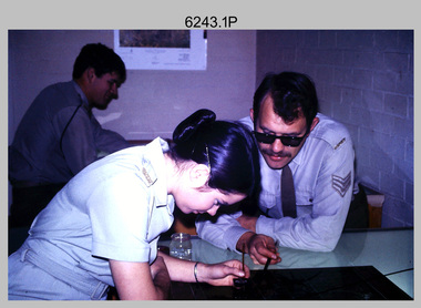
This collection of 10 photos was most likely taken in 1984. It’s evident in these photos the visitors were taken on a tour through the production areas of Air Survey Squadron, with Wild B8 photogrammetic plotting workstations featured in the first three photos and demonstrations of the AUTOMAP 2 production system in the following photos. The AUTOMAP 2 system was an upgrade to the AUTOMAP 1 system comprising Intergraph graphic edit workstation terminals networked to VAX 750/785 main frame computers. Unlike AUTOMAP 1, operators could display digital topographic features on monitors for editing. Successful adaptation of this system meant RASvy was at the forefront of digital mapping/cartographic systems in Australia and overseas. The system comprised Input (B8 feature extraction) Raster Scanning (digitising from compilation sheets, Graphic Edit (cartographic completion) and Plot Verification Sub Systems. CAPT Rob John was the project officer responsible for the acceptance trials and implementation of AUTOMAP 2. The system was operational from 1984 to its ‘Newheart’ upgrade in 1993. Throughout its life, the system was progressively refined with productivity gains, achieved from award winning technical development in-house by talented and innovative Army Survey Regiment personnel.This is a set of 10 photograph of a technical tour of the Army Survey Regiment at Fortuna, Bendigo, c1985. The photographs were printed on 35mm photographic proofing paper and are part of the Army Survey Regiment’s Collection. The photographs were scanned at 600 dpi. .1) - Photo, black & white, c1984, unidentified visitors, CAPT Rob John, MAJ Jim Mitchell, unidentified. .2) - Photo, black & white, c1984, unidentified visitor. .3) - Photo, black & white, c1984, unidentified visitor. .4) - Photo, black & white, c1984, unidentified SGT .5) - Photo, black & white, c1984, L to R: LTCOL Jorge Gruszka, unidentified visitors. .6) - Photo, black & white, c1984, L to R: SGT George Timmins, unidentified visitors. .7) - Photo, black & white, c1984, MAJ John Charland – US Exchange Officer. .8) - Photo, black & white, c1984, L to R: unidentified visitors and personnel, MAJ John Charland – US Exchange Officer. .9) - Photo, black & white, c1984, unidentified visitors and personnel, MAJ John Charland – US Exchange Officer in background. .10) - Photo, black & white, c1984, L to R: MAJ Bob Roche, CAPT Mick Byrne in Officers Mess..1P to .10P No personnel are identifiedroyal australian survey corps, rasvy, army survey regiment, army svy regt, fortuna, asr, air survey, automap -
 Bendigo Military Museum
Photograph - Wayzgoose Hall and Speedmaster Printing Press Commissioning, Army Survey Regiment, Fortuna Villa, Bendigo, 1990
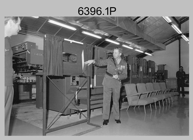
The first photograph was probably taken at a media event announcing the introduction of the Heidelberg Speedmaster printing press in late 1990. LTCOL Rene van den Tol was the CO of the Army Survey Regiment from 1989 to 1991. Partly obscured behind the CO was Mr Bruce Reid, who was the newly elected federal member for Bendigo. The media event was held in Wayzgoose Hall, Lithographic Squadron’s new purpose-built building constructed to house the Speedmaster printing press. This occasion is covered in more detail in page 143 of Valerie Lovejoy’s book 'Mapmakers of Fortuna – A history of the Army Survey Regiment’ ISBN: 0-646-42120-4. Refer to Item 6291.6P for more photos of the Open Day.This set of three photographs were taken at the commissioning ceremony of Wayzgoose Hall, the Army Survey Regiment’s new printing building and the Heidelberg Speedmaster Printing Press, at Fortuna Bendigo on Wednesday 27th June 1990. The black & white photographs were printed on photographic paper and are part of the Army Survey Regiment’s Collection. The photographs were scanned at 300 dpi. .1) - Photo, black & white, 1990. Commissioning Ceremony L to R: CO LTCOL Rene van den Tol, Commander 3rd Military District BRIG P. Davies AM ADC, WO2 Jeff Willey in background. .2) - Photo, black & white, 1990. L to R: CO LTCOL Rene van den Tol, Commander 3rd Military District BRIG P. Davies AM ADC with first printed topographic map – 8123 4 Mansfield 1:50 000. .3) - Photo, black & white, 1990. L to R: SGT Gary Kerr in background, Seligson Claire Printing Press Suppliers - Richard Rasmussen and Oliver Holliwell, Bob Martin, Director of Survey COL Don Swiney MBE, RA Svy COL CMDT COL John Hillier, Commander 3rd Military District BRIG P. Davies AM ADC, Bruce Reid Bendigo MHR..1P to .3P – Annotated on back of photos ‘Opening New Print Room BRIG Davies 27 Jun 90’. Personnel and civilians are identified.royal australian survey corps, rasvy, army survey regiment, army svy regt, fortuna, asr, litho -
 Victorian Aboriginal Corporation for Languages
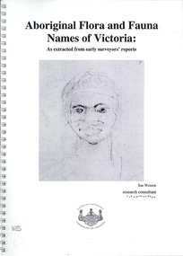
Book, Sue Wesson et al, Aboriginal flora and fauna names of Victoria : as extracted from early surveyors' reports, 2001
The Flora and Fauna Names Project is an initiative of the Victorian Aboriginal Corporation for Languages and the Victorian Biodiversity Strategy. The researcher has examined material from the archives of the Department of Natural Resources and Environment (NRE), the State Library of Victoria, the Victorian Public Records Office and the Australian Archives Office. This first stage of the project focussed on the NRE archives, in particular the field notebooks of the earliest surveyors and their maps although other NRE resources, libraries and public records were accessed. A total of 3028 words were found of which a significant proportion have previously been unknown to linguists. It appears that the place names and word lists in early surveyors notebooks, the 1858 surveyors responses to the Surveyor General and an extensive Wiradjuri wordlist by James Baylis have not yet been widely used or published. Fifteen percent of these 3028 words describe flora and fauna and six percent describe habitat. Of particular interest is the evidence provided by these lists of the existence of fauna in the mid nineteenth century in regions where it is now extinct. For example, magpie geese, eastern quolls, bustards and pademelons were assigned names in the Jardwadjali language area of the upper Glenelg and Wimmera Rivers. The outcomes of this project may help to assist in ascertaining the distribution of flora and fauna assets in Victoria.maps, b&w photographs, colour photographs, illustrations, word listswiradjuri, jardwadjali, glenelg river, wimmera river -
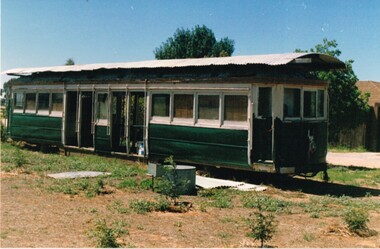 Melbourne Tram Museum
Photograph - Set of 4 Colour Print/s, Norm Cross, 1/01/1994 12:00:00 AM
Set of four colour prints of an Ex Victorian Railways bogie tram body at Sloan NSW. Photo by Norm Cross, printed on AGFA paper. Photo dated 1/1/1994. Advised by Tony Smith - 29/3/2017 "The tram in question is VR 39. It was one of the last 4 trams disposed of from Elwood depot in 1959 after the system closed. They were purchased complete by Upton's machinery dealers of Corowa. The other cars were 29, 33 & 37. He then stripped them and sold the bodies. When we obtained VR 41 in 1977 we immediately went searching for other bodies that might yield parts to help in rebuilding 41. We located 37 on the outskirts of Wangaratta and it yielded many body items including a complete drivers bulkhead that was used to replace the one in VR 41 that had been cut out with an axle by the previous owner. You may also recall that we obtained 3 complete broad gauge 77e trucks from Upton's (they had cut up the other 5 bogies years previous). These 77E trucks are now under the Christchurch Brill tram with the 3rd as a spare as we were able to obtain standard gauge 77e's when we acquired L 105 for dismantling."Each photo has written in ink on the rear "Body of VR tram # @ Sloan NSW 1 Jan 1994, photo by Norm Cross".trams, tramways, vr trams, sale of trams, scrapped trams, tram 39 -
 Bendigo Military Museum
Photograph - Retouching Reproduction Material at the Army Survey Regiment, Fortuna, Bendigo, c1975
This is a set of seven photographs of technicians retouching orthophoto reproduction material at the Army Survey Regiment, Bendigo, c1975. Retouching mainly entailed the application of liquid opaque (Plumtree), commonly known as “duff” to cover blemishes such as scratches and spots on film negatives before photographic exposure. Retouching technicians also used specialised techniques such as “needling” to repair faults on the emulsion of map reproduction material. The technicians in this set of photos were probably working on the retouching and registration of orthophotomap colour film separations in preparation for publication by Print Troop. Peter Dew featuring in photos .1P to .5P was a serving member of RA Svy, who died in a tragic accident at home. He was fondly remembered as one of Lithographic Squadron’s colourful personalities. The "Super Animal of the Year" Peter Dew Memorial Award was an award presented to a member of the squadron for a crude act. To view a photo of this award, refer to item 6230 of the Victorian Collections.This is a set of seven photographs of technicians retouching and assembling orthophoto reproduction material at the Army Survey Regiment, Fortuna, Bendigo. c1975. The photographs are on 35mm colour slides and were scanned at 96 dpi. They are part of the Army Survey Regiment’s Collection. .1) to .3) - Photo, colour, c1975. Retouching reproduction material. L to R: SPR Ralph Chant, PTE Laurie Tedford, SGT Peter Dew. .4) to .5) - Photo, colour, c1975. Retouching reproduction material. SGT Peter Dew. .6) - Photo, colour, c1975. Assembly of orthophoto colour film separations. .7) - Photo, colour, c1975. Assembly of orthophoto colour film separations, CPL Garran Hill..1P to .7P - There are no annotations stored with the 35mm slides.royal australian survey corps, rasvy, army survey regiment, army svy regt, fortuna, asr, litho -
 Falls Creek Historical Society
Photograph - Paul Hogan at Julian's Lodge 1973
Julian Newton-Brown arrived at Falls Creek in 1957. He had studied Pharmacy at Melbourne University. After developing a love for the mountains, Julian moved to Mt. Beauty and then Falls Creek. He worked for the SEC in the test laboratory at Rocky Valley reading weather instruments. By working several jobs, Julian was able to build a small lodge of 10 beds named “Arundel”, located at 18 Slalom Street, Falls Creek. The lodge is now the “Elk at Falls”. Arundel prospered and Julian extended it to include 32 beds and changed its name to "Julian’s” in 1961. When alcohol restrictions were eased in Falls Creek, Julian built a night club which he called “Big Julian’s” and later “THE MAN”. When Julian and his wife Beth retired and left Falls Creek, their son took over running the lodge. An active community man, Julian was a member of the Falls Creek Chamber of Commerce, a member of the SES, a stakeholder in Falls Creek, an author and a documentary maker. Julian Newton-Brown died in May 2020. In 2003 when this flyer was published operation of Julian's Lodge transferred from Julian and is wife Beth to their son Charlie Brown, a former Australian Champion and World Cup skier and his wife, Bena.This item is significant because it gives details of an important lodge at Falls Creek, Victoria.A black and white image of Paul Hogan, John Cornell and other people sitting near fire place in the dining room at Julian's Lodge in 1973. Paul Hogan and a group of actors and film crew spent several days in Falls Creek filming a Winfield cigarette commercial, in which they were portrayed as ski instructors. According to Julian Brown's book "Falls Creek - How it came to be", they brought in a truck load of polystyrene balls to create snow. The commercial was in 16mm for television and 36 mm for cinemas. It took them three days to shoot a six second scene in the dining room at Julian's lodge.julian's lodge, julian newton brown, falls creek ski lodges, accommodation falls creek, charlie brown -
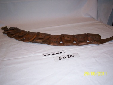 Rye RSL Sub Branch
Bandolier Amunition Leather
A piece of equipment for the storage and carriage of extra ammunition. Made up of a shoulder strap with nine closeable leather pouches, each able to carry ten rounds of ammunition. Although in their day they were purely functional, they are still worn by flag and Guidon escorts in Royal Australian Armourd Corp Units to this day in recognition of the ties to their forebears. The only difference is they are now coloured black. -
 Warrnambool and District Historical Society Inc.
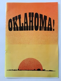
Programme - Oklahoma, 1996
This is a program for the 1996 Warrnambool Theatre Company production of ‘Oklahoma’. Amateur theatre groups of various kinds have been operating in Warrnambool since the 1860s and a group called the Warrnambool Dramatic Society was operating in the 1950s. In 1958 this group changed its name to the Warrnambool Theatre Group and at a later stage this became the Warrnambool Theatre Company. The husband and wife team of Cyril and Joyce Hayward contributed to make the theatre company well-known in the area for fine productions for over 30 years in the 1960s, 70s and 80s) . Today the Warrnambool Theatre Company continues to produce plays, musicals and concerts on a regular basis. ‘Oklahoma!’ is an oft-produced musical by Rodgers and Hammerstein (1943).This is a program of interest as an example of the type of show produced by the Warrnambool Theatre Company in 1996. This is a 1996 Warrnambool Theatre Company production of ‘Oklahoma’. It has 16 pages and an orange-coloured cover with an image of a rising sun and a landscape outline on the front cover and a Warrnambool Standard advertisement on the back cover. The program contains black and white advertisements, information on the production, cast and crew and photographs of those involved in the production. The pages were stapled but the staples have been removed. ‘oklahoma!’, warrnambool theatre company -
Frankston RSL Sub Branch
Glass, Souvenir
A pair of wine glasses, perhaps sherry glasses. These were made for the 3rd anniversary celebrations of the opening of the new Frankston Returned & Services League of Australia club building held in 1979. The glasses feature an image of the new club building and details of the history of the club in gold leaf applied to the external surface of the glass. The glasses are made from clear glass and are gold lipped.These glasses are inscribed with the following in gold leaf: "FRANKSTON R.S.L. 3rd ANNIVERSARY 1979" beneath an image of the new club building and a brief précis of the major events in the club history. -
 Frankston RSL Sub Branch
Boots, Riding
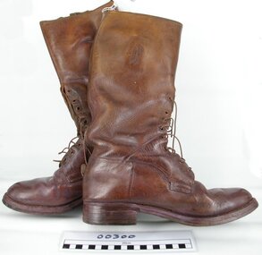
Pair of leather riding boots as issued to the Australian Light Horse servicemen during World War 1. These boots are designed to fit the feet and lower calf and are worn laced. They are made of tan coloured leather with leather soles and have leather laces. These boots were issued to Captain Lewis George Cole of the 3rd Light Horse Brigade (refer supplementary documents attached).world war 1, ww1, australian light horse, alh, cole -
Frankston RSL Sub Branch
Photographs
Photographs (82 off) from the collection of Sergeant R. K. Churches, service number VX34599. These monochrome 35mm photographs were taken by Churches whilst a POW at Changi, Singapore. His unit, the Australian Army 2/9th Field Ambulance, surrendered to the Japanese when Singapore fell in February 1942 during World War 2. (refer item number 00320) -
 Federation University Historical Collection
Book, The Craftsman (July -Dec 1912 and Jan-June 1913), 1912-1913
Two large half leather bound volumes. The books were once part of the Ballarat Technical Art School Library. .1) July - December 1912. Includes a book plate from the Ballarat Technical Art School Library (BM/98) .2) January- June 1913. Includes a book plate from the Ballarat Technical Art School Library (BM/99)john burroughs, california, architecture, garden furniture, peer gynt, norway's ancient log cabins, king's langley's priory, lincoln memorial school, wrought iron, school gardens, birch bark canoes, old west, alice in wonderland, californian bungalow, japanese gardens, john muir, yosemite, san stefano, bologna, brickwork, anna boberg, ctaftsman house, henrik lund, water gardens, lois akin, electric lighting, bookplate, library plate, ballarat technical art school -
 Bendigo Historical Society Inc.
Newspaper - JENNY FOLEY COLLECTION: STURDY
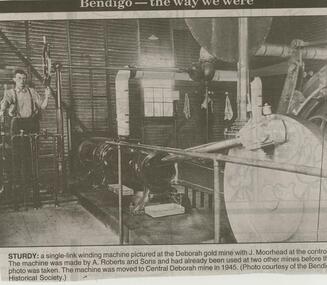
Bendigo Advertiser ''The way we were'' from 2000. A single-link machine pictured at the Deborah gold mine with J. Moorhead at the controls. The machinery was made by A. Roberts and Sons and had already been used at two other mines before this photo was taken. The machine was moved to Central Deborah mine 1945. (Photo courtesy of the Bendigo Historical Society). The clip is in a folder.newspaper, bendigo advertiser, the way we were -
 Bendigo Historical Society Inc.
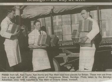
Newspaper - JENNY FOLEY COLLECTION: FOOD
Bendigo Advertiser ''The way we were'' from 2000. Food: from left, Alan Taylor, Ken Norris and Ras Mein load food parcels for Britain. These men are three from a large staff of W. Jeffrey, grocer of Hargreaves street, Bendigo. Photo taken by the Bendigo Advertiser, circa 1948, supplied by Ras Mein of Victoria street Ironbark. The clip is in a folder.newspaper, bendigo advertiser, the way we were -
 Bendigo Historical Society Inc.
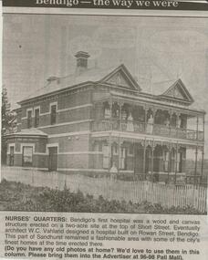
Newspaper - JENNY FOLEY COLLECTION: NURSES' QUARTERS
Bendigo Advertiser ''The way we were'' from 2000. Nurses' quarters: Bendigo's first hospital was a wood and canvas structure erected on a two-acre site at the top of Short Street. Eventually architect W.C. Vahland designed a hospital built on Rowan Street, Bendigo. This part of Sandhurst remained a fashionable area with some of the city's finest homes at the time erected there. The clip is in a folder.newspaper, bendigo advertiser, the way we were -
 Bendigo Historical Society Inc.
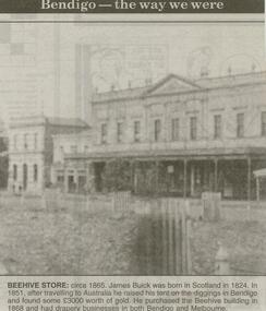
Newspaper - JENNY FOLEY COLLECTION: BEEHIVE
Bendigo Advertiser ''The way we were'' from 2000. Beehive store: circa 1865. James Buick was born in Scotland in 1824. In 1851, after travelling to Australia he raised his tent on the diggings in Bendigo and found some 3,000 pounds worth of gold.. He purchased the Beehive building in 1868 and had drapery businesses in both Bendigo and Melbourne. The clip is in a folder.newspaper, bendigo advertiser, the way we were -
 Bendigo Historical Society Inc.
Book - COHN BROTHERS COLLECTION: WAGES LEDGER 1918 - 1921
Dark green, buff spine and corners book. Written on outside of spine 'Wages Book' Contains following information, in columns as listed, re employees: Name of Employee, Computation of Wages, Overtime, Total Amount. Signature of employee. Each week ending has a summary of where salaries were earned, in addition to wages earned. Amount paid in cheques also listed.business, cohn brothers, wages book, cohn bros, bendigo, brewing, cordial manufacture