Showing 37336 items matching " 12"
-
 Surrey Hills Historical Society Collection
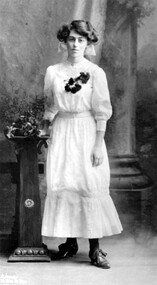
Photograph, Mabel Pye, daughter of William and Alice Pye of 12 Loch Street, Surrey Hills
Mabel Pye was a printmaker and painter. She was born in Box Hill in 1894, probably at the family’s Loch Street property. She was the daughter of Alice Eleanor Noar and her husband William Edward Pye, who married in 1893. William was known as Ted and is recorded in electoral rolls as a legal clerk and later as a public servant. Mabel had a sister Hazel who was also an artist, but less well known. 12 Loch Street, Surrey Hills was known as ‘Mulberry Hill’ and the Pyes appear to be the first occupants – Alan Holt’s register of Surrey Hills properties has them there from c1900. The property was originally about an acre in size and was later divided into 4 house blocks. In 1923 they built a house for themselves on one of the blocks facing Benwerrin Street and called it ‘Tanglewood’. The Loch Street house abutted the Surrey Hills Reservoir and was diagonally linked to the land in Benwerrin Street. In 2019 both the houses still stand. The family were involved in amateur theatre and at times the studio doubled as a rehearsal space for the Benwerrin Players, a group which operated through the late 1920s and early 1930s being comprised of friends and neighbours from Benwerrin Street and Windsor Crescent. Some of their performances were at the Surrey Hall in Union Road. Most of Mabel’s known work dates from the 1930s. She had studied under Bernard Hall at the National Gallery School. Mabel was a member of both the Victorian Artists Society from 1918-1941 and also the Melbourne Society of Women Painters and Sculptors from 1920-1950. Her work is represented in the Australian National Collection and in state galleries. The NGV has one of her works, the Gallery of NSW has 9 works, a large body of works and personal material is held by the Ian Potter Collection and there is one piece in the City of Whitehorse Collection. This ink sketch of the White Horse Hotel is signed MP and dated 1933, the year the building was demolished. A black and white studio photograph of a young lady standing beside a pedestal and wearing a light coloured dress with 3/4 length sleeves, dark stockings and lace up shoes. A corsage of dark flowers adorns the bodice. loch street, surrey hills, artists, whitehorse hotel, box hill, miss mabel pye, city of whitehorse collection, william edward pye, miss alice elanor noar, mrs alice eleanor pye, frank stamford -
 Glen Eira Historical Society
Plan - St James Parade, 12, Elsternwick
Hand drawn pencil plan of 12 St. James Parade, Elsternwick, unknown author and undated.st. james parade, elsternwick, plans -
 Melbourne Tram Museum
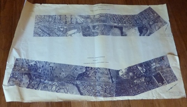
Drawing, Melbourne & Metropolitan Tramways Board (MMTB), Aerial photographs Bundoora Tram Extensions, Plenty Road – MMTB Drawings – 12/1979, Bundoora Extension – Metropolitan Transit Authority – 2/1983, John-Connell – Mott Hay and Anderson – Preliminary drawings for the Latrobe Modal Interchange – August 1984, 1979 to 1984
Set of drawings for the MMTB Plenty Road extension in 1979, MTA extension to Bundoora in 1983 and the Latrobe Uni Modal Interchange - 1984. Large print – Aerial photographs Bundoora Tram Extensions Stage 2 – Albert St to Kingsbury Drive Stage 3 – Kingsbury Drive to Settlement Road Has been rolled, left hand edge damaged, right hand edge torn Compiled by the ROW Division – 2/1981. Has written on rear at right hand end “Bundoora Tram Extension – Official MMTB Plans” 760H x 1190W Plenty Road – MMTB Drawings – 12/1979 P15123 Tyler St to Walsal Avenue P15124 Walsal Ave t McColl St P15125 McColl St to Dorrington Avenue Bundoora Extension – Metropolitan Transit Authority – 2/1983 P15400 Dorrington Avenue to Barwon Avenue P15401 Barwon Avenue to Nicholson Ave P15402 Nicholson St to Barling Park P15403 Barling Park to Darebin Creek P15404 Darebin Creek to Scott Grove P15405 Scott Grove to Clunes Street P15406 Clunes St to Cash St P15408 Cash St to Bundoora Park P15409 Bundoora Park to Larundel Hospital P15410 At Larundel Hospital P15411 Larundel Hospital to Marne Court P15412 Marne Court to Cherrywood Court P15413 Cherrywood Court to Morwell Ave P15414 Morwell Ave to Grimshaw St P15415 Grimshaw St to Nickson Street P15416 Nickson St to McLeans Road John-Connell – Mott Hay and Anderson – Preliminary drawings for the Latrobe Modal Interchange – August 1984. 8094-A-20 Set Out Plan and Paving Details 8094-A-21 Elevations 8094-A-22 Sections 8094-A-23 Roof Plan and Stormwater Layout 8094-A-24 Canopy Details 8094-A-25 Toilet Block and Waiting Room 8094-A-28 Miscellaneous DetailsOn rear of aerial photograph sheet - at right hand end “Bundoora Tram Extension – Official MMTB Plans” in felt pen.trams, tramways, plenty rd, bundoora, latrobe university, mmtb, construction, mta -
 Ballarat Tramway Museum
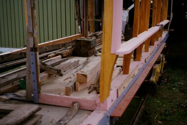
Photograph - Colour Photograph/s - set of 2, Warren Doubleday, 12/07/1997 12:00:00 AM
Has a strong association with a BTM/BTPS volunteer - 1990'sSet of two Colour photographs of work on ESCo No.12 showing the side framing on the tram. One of the two photos used in July 1997 issue of Fares Please! Photo taken on 12/7/1997 by Warren Doubleday. Printed on Kodak Paper. See July 1997 Fares Please!On ink on rear "12/7/97"btm, esco, reconstruction, tram 12 -
Glen Eira Historical Society
Article - PRENTICE STREET, 12, ELSTERNWICK
Newspaper real estate ad, undated, including 3 coloured photographs, on forthcoming auction Saturday 15/05 of 12 Prentice Street, giving brief interior features.elsternwick, prentice street, edwardian styles, harleston park -
 Learmonth and District Historical Society Inc.
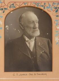
Photo - Jones, Richards & Co. Photos Ballaarat, G.T.Jones,Secretary and Engineer.1906, "Circa 1912"
Mr. G.T.Jones was Secretary and Engineer for the council year 1911-12. Original Historic Photo.Sepia photo,rectangular with curved top,of Mr.G.T.Jones,Secretary and Engineer.It is in a pinkish/tan mount with decorative features of flowers ,in tan blue and white, around top. it is second from left of bottom row of collection of photos of all councilors and staff for 1911-12.Presented to the Ballarat Shire Council. J.Dickie Esq. J.P.,President 1911-12.ballarat shire council, 1911 12, jones g t, secretary and engineer -
Glen Eira Historical Society
Letter - St. Georges Road, 12, Elsternwick
A Letter To The Residents Of St. Georges Road Regarding The Filming To Take Place At 12 St. Georges Road On 6/9 And Betweek 9/9 and 13/9. The Letter Is Undated And Signed By Harrison, Jennie.abc, television stations, street angels, st. georges road, entertainment, elsternwick, harrison jennie -
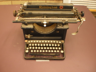 Wangaratta High School
Typewriter
Remington Standard 12 Typewriter Black metal typewriter and metal keyboard and levers. Gold Remington logo and red Remington symbolRemington 12 12 Remington Standard -
Glen Eira Historical Society
Letter - Avoca Grove, 12, Caulfield North
Typewritten letter dated 18/04/1975 from the National Trust of Australia (Victoria) to Trevor Hart of Filbert St, 14, Caulfield, concerning the non-classification status of property at Avoca Grove, 12, Caulfield North.hart trevor, buildings, merton, caulfield north, avoca grove, structures and establishments -
 Ballarat Tramway Museum
Photograph - Colour Photograph/s - set of 6, Warren Doubleday, 12/12/1998 12:00:00 AM
Set of six colour photographs taken by Warren Doubleday on 12/12/1998 of Museum activities and works. On Kodak paper. .1 - Depot Junction - showing road necking works at point were depot access track crossed Wendouree Parade. Photo used in Jan. 1999 issue of Fares Please! .2 - 26 southbound at Depot Junction, with conductor John Clowes boarding tram. .3 - 26 northbound at depot junction showing roadworks and BTM members. .4 - Alastair Reither and Simon Jenkins crossing four road at depot. .5 - Wendouree Parade at Depot junction looking south. .6 - Anita Bagley driving 26, northbound from Depot Junction with Alastair Reither and Darren Hutchesson standing along depot junction. Photo used in Jan. 1999 issue of Fares Please!On back of photos in ink "12/12/98"btm, depot junction, road works, tram 26 -
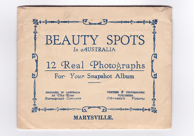 Marysville & District Historical Society
Photograph (item) - Black and white photographs, Rose Stereograph Company, Beauty Spots In Australia-Marysville, 1913-1967
An envelope with 12 black and white photographs of scenic attractions taken in and around Marysville in Victoria. An envelope with 12 black and white photographs of scenic attractions taken in and around Marysville in Victoria. The photographs were used for a series of photographs and postcards published by the Rose Stereograph Company in Armadale, Victoria.12 Real Photographs/ For Your Snapshot Album PRODUCED IN AUSTRALIA/ BY The Rose/ Stereograph Company PRINTERS & PHOTOGRAPHIC/ PUBLISHERS/ Armadale, Victoriakeppel falls (image 1), cumberland falls (image 2), track to cora lynn falls (image 3), nichol's lookout (image 4), cameron cascades (image 5), stevenson falls (image 6), taggerty river (image 7), main street (image 8), taggerty river (image 9), talbot drive (image 10), cora lynn falls (image 11), taggerty river (image 12), rose series postcard, rose stereograph company, souvenir -
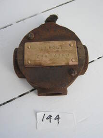 Parks Victoria - Wilsons Promontory Lightstation
Part, electrical
Used as a junction box for metal conduit in RAAF power house.This technical item has second level significance because their use is likely to be directly linked to WWII communications activity at the lightstation:Round metal piece with protrusions and with "12 VOLT / CHARGING" stamped on a metal plate on the front."12 VOLT / CHARGING" -
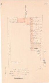 Ringwood and District Historical Society
Map - Plan of Survey, Part of Crown Portion 12, Parish of Ringwood, Victoria - circa 1930
Map of area bounded by Ringwood Street, Melbourne Street and Adelaide Street, showing details of Adelaide Street allotments and existing outbuildings. Certificate of Title numbers include Ringwood Street C/T 3418-553, C/T 3563-433, Adelaide Street C/T 7151-047, C/T 7038-465, C/T 7098-464, C/T 7098-465, C/T 3604-635, C/T 8066-900, C/T 3866-118, C/T 3609-728, and C/T Vol 3670 Fol 133992.Subsequent additional notations identifying 1971 closure of Melbourne Street North, and properties of Hone, Patendon, Pines Hosptial, Mail Office, Presbyterian Church and Falconers Grocery Shop on Whitehorse Road corner. -
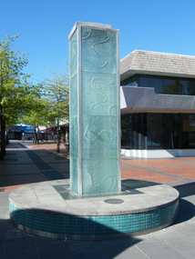 Ringwood and District Historical Society
Photograph, Water feature in Melbourne Street, Ringwood in 2008. It was provided by Maroondah City Council, officially opened on 12 March 1997 to mark the creation of MCC, but rarely having water turned on
Photographic record by Russ Haines, RDHS, in 2008. -
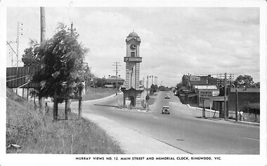 Ringwood and District Historical Society
Photograph/Postcard, Postcard and souvenir photograph - Murray Views No.12. Main Street and Memorial Clock, Ringwood, Vic
Black and white "Murray Views" postcard and souvenir photograph - Ringwood Memorial Clocktower, looking west from cnr. Warrandyte Road and Maroondah Highway, Ringwood, Vic. Circa late 1940s.Printed on back - Post Card - Real Photographs produced in Australia by Murray Views, Gympie, Q. Handwritten - "1949 or 48". -
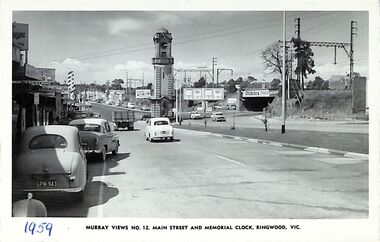 Ringwood and District Historical Society
Photograph/Postcard, Postcard - Murray Views No.12. Main Street and Memorial Clock, Ringwood, Vic
Black and white "Murray Views" postcard - Maroondah Highway looking east towards Memorial Clock Tower on Warrandyte Road intersection; railway bridge on right. Circa 1959."1959" handwritten on front. -
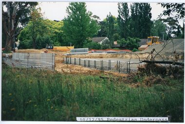 Ringwood and District Historical Society
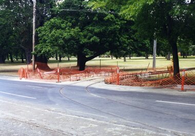
photograph, Eastlink Ringwood Bypass Construction-Pedestrian Underpass 10/12/95
Colour photographWritten on back of photo: "Ringwood Bypass Pedestrian Underpass- near Suda Av" -
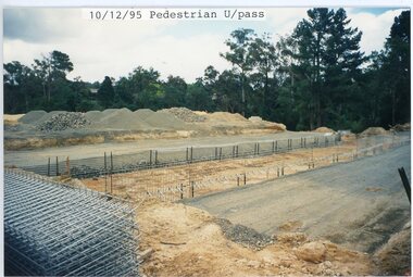 Ringwood and District Historical Society
photograph, Eastlink Ringwood Bypass Construction-Pedestrian Underpass 10/12/95
Colour photographWritten on back of photo: "Ringwood Bypass-Pedestrian Underpass-near Suda Av" -
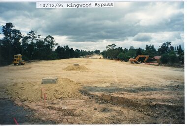 Ringwood and District Historical Society
photograph, Eastlink Ringwood Bypass Construction-Ringwood Bypass 10/12/95
Colour photographWritten on back of photo: "Ringwood Bypass-Looking toward Mt Dandenong Rd" -
 Ringwood and District Historical Society
Photograph, New Street being built next to 12 Georges Street to Oliver Street, Ringwood on 8th November 1992
Digital photograph -
 Ringwood and District Historical Society
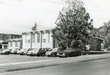
Photograph, Scots Church Hall before demolition, as seen from Warrandyte Road, Ringwood on 12 October 1992
Digital photograph -
 Ringwood and District Historical Society
Photograph, 12 Warrandyte Road, Ringwood. Now a car park for 10 Warrandyte Road 21 October 1992
Digital photograph -
 Ringwood and District Historical Society
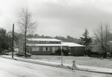
Photograph, Adelaide Street, Ringwood, Scots Church Hall on 12 September 1988
Digital photograph -
 Ringwood and District Historical Society
Photograph, Scots Church Hall, Ringwood on 12 September 1988
Digital photograph -
 Ringwood and District Historical Society
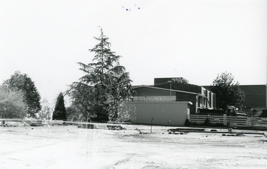
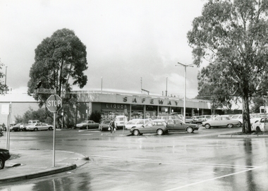
Photograph, Safeways, Ringwood, corner of Maroondah Hwy and Warrandyte Road on 12 September 1988
Digital photograph -
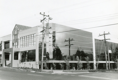 Ringwood and District Historical Society
Photograph, New building at corner of Ringwood and Nelson Streets, Ringwood on 12 September 1988
Digital photograph -
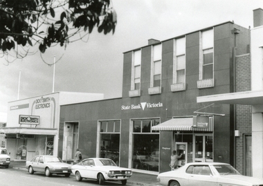 Ringwood and District Historical Society
Photograph, Maroondah Highway, Ringwood, State Bank on 12 September 1988
Digital photograph -
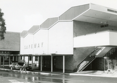 Ringwood and District Historical Society
Photograph, Safeways (later Woolworths), rear of Eastland, Ringwood on 12 September 1988
Digital photograph -
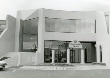 Ringwood and District Historical Society
Photograph, 88 Maroondah Highway, Ringwood on 12 September 1988
Digital photograph -
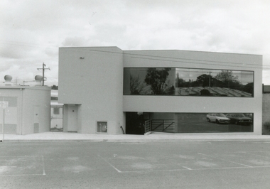 Ringwood and District Historical Society
Photograph, Rear of 88 Maroondah Highway, Ringwood on 12 September 1988
Digital photograph