Showing 1534 items
matching aerial photographs
-
 Glenelg Shire Council Cultural Collection
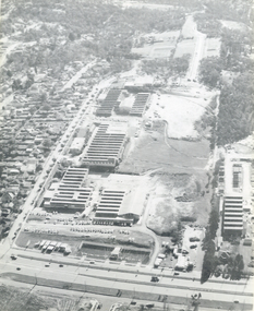
Photograph - Photograph - Aerial view of CSR Softwoods plant, Portland, c. 1974
... Photograph - Aerial view of CSR Softwoods plant, Portland...Unframed, black and white aerial photograph, taken from..., black and white aerial photograph, taken from the N.W., of C.S.R ...Port of Portland CollectionFront: (no inscriptions) Back: (no inscriptions)port of portland archives, aerial photography, portland harbour -
Glenelg Shire Council Cultural Collection
Photograph - Photograph - Aerial view of CSR Softwoods plant, Portland, c. 1974
... Photograph - Aerial view of CSR Softwoods plant, Portland...Unframed, black and white aerial photograph, taken from..., black and white aerial photograph, taken from the N.W., of C.S.R ...Port of Portland CollectionUnframed, black and white aerial photograph, taken from the N.W., of C.S.R. Softwoods plant, Darts Road Portland under construction, various wool stores; skin sheds at Thomas Borthwick & Sons abattoir.Front: (no inscriptions) Back: (no inscriptions)port of portland archives, aerial photography, portland harbour -
Glenelg Shire Council Cultural Collection
Photograph - Photograph - aerial view of Portland coastline, c. 1954
... Photograph - aerial view of Portland coastline...Black and white aerial photograph of coastline around... aerial photograph of coastline around Portland. Black border ...Black and white aerial photograph of coastline around Portland. Black border, scale all sides, 5 rows of 3 't' at regular intervals. 10% ocean, 90% land. See 'Other Information'Front: '820- 52' - handwritten, white, border 'RUN 6' 'PORTLAND', printed, white, borderport of portland, aerial photography, south west coastline -
Glenelg Shire Council Cultural Collection
Photograph - Photograph - aerial view of Portland, c. 1954
... Photograph - aerial view of Portland...Black and white aerial photograph of coastline around..., white, border Black and white aerial photograph of coastline ...Black and white aerial photograph of coastline around Portland. Black border, scale all sides, 5 rows of 3 't' at regular intervals. 25% ocean, 75% land. See 'Other Information'Front: '820 - 50' - handwritten, white, border 'RUN 6' 'PORTLAND', printed, white, borderaerial photography, central portland, portland harbour, south west coastline -
Glenelg Shire Council Cultural Collection
Photograph - Photograph - aerial view of Portland, c. 1954
... Photograph - aerial view of Portland...Black and white aerial photograph of coastline around...', printed, white, lower border Black and white aerial photograph ...Black and white aerial photograph of coastline around Portland. Black border, scale all sides, 5 rows of 3 't' at regular intervals. Mostly ocean, small area of land lower left.Front: '820-6' -- handwritten, white, lower border 'RUN 5' 'PORTLAND', printed, white, lower borderaerial photography, central portland, portland harbour, south west coastline -
Glenelg Shire Council Cultural Collection
Photograph - Photograph - Aerial photograph of coastline around Portland, Victoria, c. 1954
... Photograph - Aerial photograph of coastline around Portland...Black and white aerial photograph of coastline around... Black and white aerial photograph of coastline around Portland ...Black and white aerial photograph of coastline around Portland. Black border, scale all sides, 5 rows of 3 't' at regular intervals. Bottom 20% ocean, rest land, separated by beach.Front: '607 - 88' - handwritten, white, border 'RUN - 6 PORTLAND', printed, white, border -
Glenelg Shire Council Cultural Collection
Photograph - Photograph - aerial view of Portland, c. 1954
... Photograph - aerial view of Portland...Black and white aerial photograph of coastline around..., white, border Black and white aerial photograph of coastline ...Black and white aerial photograph of coastline around Portland. Black border, scale all sides, 5 rows of 3 't' at regular intervals. Mostly ocean, small area of land, top left.Front: '607 - 49 ' - handwritten, white, border 'RUN 8' 'PORTLAND', printed, white, borderaerial photography, central portland, portland harbour, south west coastline -
Glenelg Shire Council Cultural Collection
Photograph - Photograph - aerial view of Portland, c. 1954
... Photograph - aerial view of Portland...Black and white aerial photograph of coastline around..., white, border Black and white aerial photograph of coastline ...Black and white aerial photograph of coastline around Portland. Black border, scale all sides, 5 rows of 3 't' at regular intervals. Mostly ocean, small area of land, top centreFront: '607 - 50 ' - handwritten, white, border 'RUN 8' 'PORTLAND', printed, white, borderaerial photography, central portland, portland harbour, south west coastline -
Glenelg Shire Council Cultural Collection
Photograph - Photograph - aerial view of Portland, c. 1954
... Photograph - aerial view of Portland...Black and white aerial photograph of coastline around..., white, border Black and white aerial photograph of coastline ...Black and white aerial photograph of coastline around Portland. Black border, scale all sides, 5 rows of 3 't' at regular intervals. Bottom third is ocean, the rest is land, separated by beach.Front: '607 - 89 ' - handwritten, white, border 'RUN - 6 PORTLAND', printed, white, borderaerial photography, central portland, portland harbour, south west coastline -
Glenelg Shire Council Cultural Collection
Photograph - Photograph - aerial view of Portland, c. 1954
... Photograph - aerial view of Portland...Black and white aerial photograph of coastline around..., white, border Black and white aerial photograph of coastline ...Black and white aerial photograph of coastline around Portland. Black border, scale all sides, 5 rows of 3 't' at regular intervals. Bottom half ocean, top land, separated by beach.Front: '607 - 92 ' - handwritten, white, border 'RUN - 6 PORTLAND', printed, white, borderaerial photography, central portland, portland harbour, south west coastline -
Glenelg Shire Council Cultural Collection
Photograph - Photograph - aerial view of Portland, c. 1954
... Photograph - aerial view of Portland...Black and white aerial photograph of coastline around..., white, border Black and white aerial photograph of coastline ...Black and white aerial photograph of coastline around Portland. Black border, scale all sides, 5 rows of 3 't' at regular intervals. Small strip of land across bottom. The rest is ocean.Front: '607 - 56 ' - handwritten, white, border 'RUN 7 PORTLAND', printed, white, borderaerial photography, central portland, portland harbour, south west coastline -
 Federation University Historical Collection
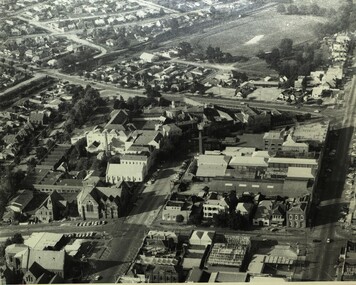
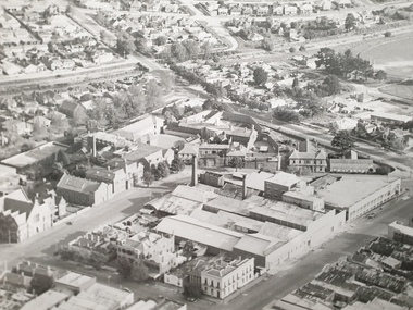
Photograph - Black and White, Aerial Photograph of the Ballarat School of Mines
... Aerial Photograph of the Ballarat School of Mines...Aerial Photograph of the Ballarat School of Mines bounded... Aerial Photograph of the Ballarat School of Mines bounded ...Aerial Photograph of the Ballarat School of Mines bounded by Armstrong Street South, Grant Street, Albert Street and Dana Street. Buildings depicted include the Ballarat Brewery, Ballarat Gaol, White Flat Ovalballarat school of mines, ballarat brewery, ballarat club, ballarat uniting church, ballarat school of mines model mine, ballarat school of mines mining workshop, ballarat girls' techncial school, albert street, white flat oval, grant street, lydiard sreet, mining laboratory, model mine, armstrong street south, james oddie's bank -
Tatura Irrigation & Wartime Camps Museum
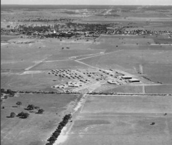
Photograph, Eildon Township, 1957
... Medium sized black and white photo. Aerial photograph... sized black and white photo. Aerial photograph - looking down ...Taken by photographer for State Rivers and Water Supply Commission.Medium sized black and white photo. Aerial photograph - looking down on township in middle foreground - overflow dam to the right, middle distance - dam wall with reservoir beyond - mountain tops forming horizonOn frame below photo: "Eildon Township."victoria state rivers and water supply commission, eildon -
 Hume City Civic Collection
Photograph, 1972
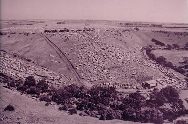
... An aerial photograph of a crowd of people on a hillside... george evans collection An aerial photograph of a crowd of people ...The photograph was taken during the 1972 Sunbury Pop Festival which was staged on a property owned by George Duncan. The site is on the banks of the Jacksons Creek between Sunbury and Diggers Rest.An aerial photograph of a crowd of people on a hillside and along a creek valley with a stage set up. On the LHS there is a large marquee surrounded by cars and pitched tents. There are trees around the creek and vast open paddocks in the distance.sunbury pop festival, jacksons creek, duncan, george, george evans collection -
 Bendigo Military Museum
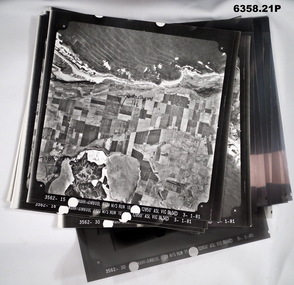
Photograph - Aerial Photography - Mohogany Ship Search Warrnambool Victoria, Victorian Lands Department, 3.1.1981
... These Victorian Lands Dept Aerial Photographs were acquired... goldfields These Victorian Lands Dept Aerial Photographs were ...These Victorian Lands Dept Aerial Photographs were acquired by the Army Survey Regiment to help locate a Mohogany Ship wreck near Warrnambool Victoria as part of a unit Regimental Training ExerciseSeven Aerial photographic Prints and Film Negatives and positives of the same images. Images are Numbered 3562- 15,16,17,18,19, 29 and 30.royal australian survey corps, rasvy, fortuna, army survey regiment, army svy regt, asr -
 Eltham District Historical Society Inc
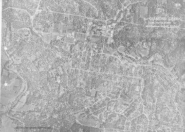
Work on paper (Sub-Item) - Aerial Photograph, Diamond Creek from Yarra River to Wattletree Road, Eltham
... Aerial Photograph...Black and white aerial photograph witrh key features around... melbourne Black and white aerial photograph witrh key features ...Black and white aerial photograph witrh key features around the central place of Eltham township marked inluding Yarra River, Main Road, Bridge Street and Ryans Road, Eltham North land development, real estate, aerial view, eltham, eltham north -
 Heidelberg Golf Club
Album - Photograph Album, Heidelberg Golf Club, Clubhouse redevelopment, 1998; Course development,2000-2001; Course redesign, 1967, 1967-2001
... . Includes aerial photographs of golf club, some stamped "proof".... Includes aerial photographs of golf club, some stamped "proof ...Album containing about 70 color photographs of Clubhouse redevelopment, 1998; Course development,2000-2001; Course redesign, 1967. Includes aerial photographs of golf club, some stamped "proof"Album #2 in the photograph collection at HGCBlack spiral bound album. Contains approx. 70 colour photographs of various sizes.heidelberg golf club, clubhouse redevelopment 1998, course design 1967, heidelberg golf course -
Glenelg Shire Council Cultural Collection
Photograph - Photograph - Portland Smelter, c. 1980
... Framed aerial photograph of Portland smelter taken in 1908... framer Framed aerial photograph of Portland smelter taken in 1908 ...Previously displayed in offices at the smelterFramed aerial photograph of Portland smelter taken in 1908's. Image shows Dutton way and Narrawong in the background. Gilt wooden frame. Glass covers photo. Brown paper on back of photo, hanging cord.Front: Back- Label for Gary Hayman, picture framer -
Port Melbourne Historical & Preservation Society
Photograph - Aerial view, Fishermans Bend, C D Pratt, 1945
... Aerial photograph c1945 with the City of Melbourne... fishermans bend war - world war ii melbourne Aerial photograph c1945 ...Aerial photograph c1945 with the City of Melbourne in the foreground, showing Fishermen's Bend. Nissen huts are visible on the beach, as is one of the airfields. Fragment of photograph missing from bottom left hand corner and three significant tearsfishermans bend, war - world war ii, melbourne -
 Whitehorse Historical Society Inc.
Photograph, Luke Group, 1959
... A small aerial photograph and 2 A4 photocopies... manufacturing industry foundries engineering industries A small aerial ...K.G. Luke had a foundry in Queen's Parade, Melbourne which made badges and manufactured items for the Armed Forces during the First World War. He bought 40 acres of cherry orchard in Mitcham in 1952 from a Miss Cook, then went to England and attracted finance from Singer Brass Founders. The company became Luke and Singer. The three factories on site were Luke Manufacturing - stainless steel products and hospital equipment, Luke and Singer - a non-ferrous foundry producing components for industry such as nuts and cutlery, and Concentric Engineering - machinery components. Later the manufacture of refrigeration and air conditioning was added at the rear of the complex. A small aerial photograph and 2 A4 photocopies of the K.G.Luke Group of companies in 1959. The factory site is divided into three groups with Whitehorse Road situated at the bottom of the photo and Cook Road Mitcham to the left. Notes at ND6245luke manufacturing, k.g.luke group, luke and singer, concentric engineering, wheatland, vic, manufacturing industry, foundries, engineering industries -
City of Kingston
Photograph - Black and white, 20 December 1945
... Aerial photograph dated 1945 of the Cheltenham area...: 57197 Aerial photograph dated 1945 of the Cheltenham area ...This photograph depicts a section of Cheltenham with a mix of housing and market gardens. The visible market gardens, farms and paddocks have gradually been sub-divided into housing, commercial and industrial estates. A large part of Cheltenham was originally established as a rural market gardening community. The railway line and station brought urban development to the area and the gradual subdivision of farmland and large land holdings for the development of housing. Aerial photograph dated 1945 of the Cheltenham area in the City of Kingston. Sydney Street (bottom left); Sinclair Street (top left); Weymar Street area off Wilson Street, Charles Street (botton right).White print VIC-170; 57197; RUN5; PROJ.No.5; MELB.METROP AREA Lens information [indecipherable] Small photograph: clockface Black ink: 57197cheltenham, market gardens, urbanisation -
Glenelg Shire Council Cultural Collection
Photograph - Photograph - Portland Harbour with oil rig, c. 1966
... onto white paper and attached to rear of photo, " Aerial... paper and attached to rear of photo, " Aerial photograph ...Port of Portland AuthorityBack: harb019 Portland Harbour Trust 7 - black pen. Typed onto white paper and attached to rear of photo, " Aerial photograph of Portland Harbour depicts the development and growth in port trade since the first stage of construction was sompleted in Novemer, 1960."port of portland archives, portland harbour, oil rig -
 Nhill Aviation Heritage Centre
Black and White photograph, Possibly Dept of Defence photograph, Nhill RAAF Base
... Aerial photograph of the Nhill RAAF base thought... to be the first aerial photo taken of the RAAF Base. raaf 1941 base Aerial ...The Nhill RAAF Base was built during WWII as part of the Empire Air Training Scheme (EATS Scheme)This is believed to be the first aerial photo taken of the RAAF Base. Aerial photograph of the Nhill RAAF base thought to be taken late 1941 or early 1942. Notice that only two of five Bellman Hangers have been built and trees have not been planted along the driveway into the base.raaf, 1941, base -
Glenelg Shire Council Cultural Collection
Photograph - Photograph - aerial view of Portland, c. 1954
... Photograph - aerial view of Portland...Black and white aerial photograph of coastline around..., white, border Black and white aerial photograph of coastline ...Black and white aerial photograph of coastline around Portland. Black border, scale all sides, 5 rows of 3 't' at regular intervals.Mostly ocean, strip of land down right hand edge and across bottom.Front: '607 - 55 ' - handwritten, white, border 'RUN 7 'PORTLAND', printed, white, borderaerial photography, central portland, portland harbour, south west coastline -
Glenelg Shire Council Cultural Collection
Photograph - Photograph - Aerial view of coastline around Portland, Victoria, c. 1954
... Photograph - Aerial view of coastline around Portland...Black and white aerial photograph of coastline around... Black and white aerial photograph of coastline around Portland ...Black and white aerial photograph of coastline around Portland. Black border, scale all sides, 5 rows of 3 't' at regular intervals. Top half is ocean, bottom half is ? beach; sand dunes, cliffs.Front: '607 - 61 ' - handwritten, white, border 'RUN 7 PORTLAND', printed, white, border -
Glenelg Shire Council Cultural Collection
Photograph - Photograph - aerial view of Portland, c. 1954
... Photograph - aerial view of Portland...Black and white aerial photograph of coastline around..., white, border Black and white aerial photograph of coastline ...Black and white aerial photograph of coastline around Portland. Black border, scale all sides, 5 rows of 3 't' at regular intervals. Further along to left, almost straight 60/40 ocean to land.Front: '784 - 152' - handwritten, white, border 'RUN 7 A PORTLAND', printed, white, borderaerial photography, central portland, portland harbour, south west coastline -
Glenelg Shire Council Cultural Collection
Photograph - Photograph - aerial view of Portland, c. 1954
... Photograph - aerial view of Portland...Black and white aerial photograph of coastline around...', printed, white, lower border Black and white aerial photograph ...Black and white aerial photograph of coastline around Portland. Black border, scale all sides, 5 rows of 3 't' at regular intervals. Fifty percent ocean, 50 percent land. See 'Other Information'Front: '820 -49' - handwritten, white, lower border 'RUN 6' 'PORTLAND', printed, white, lower borderaerial photography, central portland, portland harbour, south west coastline -
Glenelg Shire Council Cultural Collection
Photograph - Photograph - aerial view of Portland, c. 1954
... Photograph - aerial view of Portland...Black and white aerial photograph of coastline around..., white, border Black and white aerial photograph of coastline ...Black and white aerial photograph of coastline around Portland. Black border, scale all sides, 5 rows of 3 't' at regular intervals. Three quarters ocean, one quarter land. See Other InformationFront: '820 -48' - handwritten, white, border 'RUN 6' 'PORTLAND', printed, white, borderaerial photography, central portland, portland harbour, south west coastline -
Glenelg Shire Council Cultural Collection
Photograph - Photograph - aerial view of Portland, c. 1954
... Photograph - aerial view of Portland...Black and white aerial photograph of coastline around..., white, border Black and white aerial photograph of coastline ...Black and white aerial photograph of coastline around Portland. Black border, scale all sides, 5 rows of 3 't' at regular intervals. Both sides of headland can be seen. 60/40 ocean to landFront: '784 - 150 - handwritten, white, border 'RUN 7 A PORTLAND', printed, white, borderaerial photography, central portland, portland harbour, south west coastline -
 Federation University Historical Collection
Photograph - Photograph - Black and White, Aerial Photograph of the Ballarat School of Mines and Ballarat East, Pre 1967
... Aerial Photograph of the Ballarat School of Mines and...aerial photograph...Black and white aerial photograph of the Ballarat School... street south white flat oval aerial photograph Black and white ...Black and white aerial photograph of the Ballarat School of Mines, White Flat Oval, Ballarat Gaol, Ballarat Brewery, Ballarat Club, Uniting Church, John Valves (Lydiard Street), Ballarat Girls' Technical School and Ballarat ballarat gaol, white flat, ballarat uniting church, ballarat girls' technical school, armstrong street south, lydiard street south, yarrowee channel, humffray street south, m.b. john, john valves, former ballarat gaol, ballarat brewery, dana street, grant street, lydiards street south, white flat oval, aerial photograph