Showing 493 items matching " county of bendigo"
-
 Bendigo Historical Society Inc.
Map - DARGILE, November 1953
Map: Dargile, County of Rodney. Parish plan ( number 162 in Map Cupboard 1)map, rodney, parish plan, dargile , county of rodney -
Bendigo Historical Society Inc.
Map - REDESDALE, See above
Map: two maps on either side of backing, (1) Township of Redesdale, Parish of Redesdale. (2) Surban lands, Parish of Spring Plains, County of Dalhousie. Date are 26th May 1873 and 12/07/1909 ( number 157 in Map Cupboard 1)map, dalhousie, township, redesdale, parish of spring plains, county of dalhousie -
Bendigo Historical Society Inc.
Map - VICTORIA, Circa 1926
... Bendigo Historical Society Inc. Bendigo Historical Society ...Map: Map showing Counties, including Railway lines and Geographic features. Compiled and engraved at the Department of Lands and Survey Melbourne, Revised October 1926 ( number 184 in Map Cupboard 1)map, victoria, counties, counties of victoria, geographic features -
 Bendigo Historical Society Inc.
Document - MCCOLL, RANKIN AND STANISTREET COLLECTION: NEW STAR GOLD MINE HARRIETVILLE NL, 1935
McColl Rankin & Stanistreet, New Star Gold Mine Harrietville NL. a/ Agreement to purchase the mining operations and land at Black Snake Creek, Dargo, Mining District of Gippsland. For Mining Leases numbers 5187 & 5195, 31 acres. The purchaser Company is to be called Kong Meng Gold Reefs NL. Dated: 16/2/1935. Signed: J A Michelsen?, C Kingsley?, J Stanistreet, E R Grelis & ??? Inscriptions: Signed sealed and delivered by the said Ronald Alexander Rankin in the presence of E R Grelis. b/ Leasehold. Transfer of Land situated in the Parish of Dargo County of Dargo Mining District of Gippsland from New Star Gold Mine Harrietville NL to Kong Meng Gold Reefs NL. Dated: 12/3/1935. Signed: G ??, Geo ??, Stanistreet, G ??, Jamie Jeps ? Markings: pencil line through Gold Mining Lease No. 5187 change to a Leasehold Estate, line through January to be changed to March. c/ Indenture (copy of b/ with adjustments made) New Star Gold Mine Harrietville NL with Kong Meng Gold Reefs NL. Dated 13/3/1935. Signed: G ??, Geo ??, Stanistreet, G ??, Jamie Jeps ?, Stanistreet. d/ Carbon copy of a/. Signed: J A Michelsen?, C Kingsley?, J Stanistreet, E R Grelis & ??? Inscriptions: Signed sealed and delivered by the said Ronald Alexander Rankin in the presence of E R Grelis, J Stanistreet. e/ Indenture, agreement between New Star Gold Mining Harriet NL and Kong Meng Gold Reefs NL, was on the 9/3/1935 registered and Incorporated under the Companies act 1928 Part 2. Signed: E R Grelis, J Stanistreet, G ??, Geo ??, Stanistreet, G M?, Stanistreet. Dated: 12/3/1935.organization, business, gold mine, mccoll rankin & stanistreet new star gold mine harrietville nl black snake creek parish of dargo county of dargo mining district of gippsland mining leases numbers 5187 & 5195 kong meng gold reefs nl 1935 -
Bendigo Historical Society Inc.
Map - HARCOURT, No date visible
Map: Township of Harcourt, Parish pf Harcourt, County of Talbot, (number 265 in map cupboard 1)map, talbot, township, harcourt -
Bendigo Historical Society Inc.
Map - HARCOURT, 2/04/1917
Map: Town of Harcourt, County of Talbot. Parish plan (number 264 in map cupboard 1)map, talbot, township, harcourt -
Bendigo Historical Society Inc.
Map - CROSBIE, 26/09/1878
Map: Crosbie, County of Rodney. Parish plan (number 260 in map cupboard 1)map, rodney, parish plan, crosbie, county of rodney -
Bendigo Historical Society Inc.
Map - TOWNSHIP OF HEATHCOTE (PART), 11/04/1935
Map: Township of Heathcote (part), Parish of Heathcote, County of Dalhousie. Parish plan (number 259 in map cupboard 1)map, dalhousie, township, heathcote, copunty of dalhousie -
Bendigo Historical Society Inc.
Map - RODNEY, No date visible
Map: Rodney, plan of the whole County of Rodney showing reserves under the Forest Act 1907 (number 257 in map cupboard 1)map, rodney, reserves, rodney, forest act 1907, reserves -
Bendigo Historical Society Inc.
Map - TOWNSHIP OF HEAHCOTE SHEET 1, 29/07/1935
Map: Township of Heathcote sheet 1, parish of Heathcote, County of Dalhousie. Parish plan (number 253 in map cupboard 1)map, dalhousie, township, heathcote, conty of dalhousie -
Bendigo Historical Society Inc.
Map - MUSKERRY, 23/01/1888
Map: Muskerry , County of Rodney. Parish plan. ( number 251 in Map Cupboard 1)map, rodney, parish plan, muskerry -
Bendigo Historical Society Inc.
Map - WESTON, 21/10/1876
Map: Re-Survey of part of the parish of Weston, County of Rodney. Parish plan (number 309 in map cupboard 1)Murray and Hargreave, Authorised surveyorsmap, rodney, parish plan, parish of weston, murray and hargreave -
Bendigo Historical Society Inc.
Map - SALISBURY WEST, 29/01/1878
Map: Salisbury West, County of Gladstone. Parish plan (number 305 in map cupboard 1)map, gladstone, parish plan, salisbury west -
Bendigo Historical Society Inc.
Map - REDCASTLE, 15/10/1878
Map: Redcastle, County of Rodney. Parish plan. (number 293 in map cupboard 1)map, rodney, parish plan, redcastle -
Bendigo Historical Society Inc.
Map - RUNNYMEDE, 2/05/1895
Map: Runnymede, County of Rodney. Parish plan (number 285 in map cupboard 1)map, rodney, parish plan, runnymede, county of rodney -
Bendigo Historical Society Inc.
Map - DARGILE, 14/10/1906
Map: Parish of Dargile, County of Rodney. Parish plan (number 324 in map cupboard 1)map, rodney, parish plan, dargile -
Bendigo Historical Society Inc.
Map - HEATHCOTE, 11/04/1935
Map: Parish of Heathcote, County of Dalhousie. Parish plan (number 320 in map cupboard 1)map, dalhousie, parish plan, heathcote -
 Bendigo Historical Society Inc.
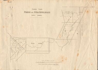
Document - MARKS COLLECTION: MAP OF PARISH OF STRATHFIELDSAYE 1858, 8th September, 1858
Buff coloured document. On top 'Country Lands, Parish of Strathfieldsaye, County Unnamed'. On bottom 'Scale 40 chains to an inch. Public Lands Office, Melbourne Sept 8th. 1858. William Collis, Lith ( lithographer )'. Map shows Village Reserve on Emu Creek, road from Sandhurst, Sheepwash Creek and Splitters Creek. Wellington Hotel marked on map near intersection of Sheepwash Creek, Axe Creek and Emu Creek. Axe Creek Pound near Splitters Creek.map, bendigo, parish of strathfieldsaye 1858 -
 Bendigo Historical Society Inc.
Document - BOARD OF WORKS, MELBOURNE: CONTRACTS ACCEPTED & LAND SALES FOR 1860
Page 2223 titled Contracts Accepted - (Series 1860). Contracts accepted are for Raising and removing sunken ship Marilla; Removal of Toll-gate from Mount Alexander Road and re-erection of same at Middle Gully; Erection of toll-house on Melbourne/Ballarat Road near Ballan; Erection of toll-house on Bendigo Road at Kangaroo Flat; Castlemaine to Ballarat - Erection of toll-house at Campbell's Creek; Construction of 2870 chains of Lower Western Road, west of Camperdown; Erection of two bridges and other improvements on the Clunes to Amherst Road; Erection of timber bridge, & c., over Two-mile Creek - Beechworth to Bowman Forest; Formation of roadway at head of Buckland Gap - Beechworth to Bowman Forest; Construction of culvert, & c., Rowe's Creek - Beechworth to Bowman Forest; Ararat and South-western sea-board road - erection of bridge over Dennicull Creek and other improvements. Land Sales - 4 Lots - Elsternwick, parish of Prahran, County of Bourke; 2 Lots - Dandenong, County of Bourke; 20 Lots - Lillydale, Parish of Yering, County of Evelyn, 1 suburban Lot - County of Evelyn, Parish of Yering; 1 Allotment - Romsey, County of Bourke, Parish of Lancefield; 5 Lots - County of Mornington, Parish of Langwarrin, and 2 Lots - County of Mornington, Parish of Fingal. Lots to be sold at the Auction Rooms of Mr. William Perry, Great Collins Street, Melbourne. A F A Greaves, President, Office of the Board of Land and Works, Melbourne.bridge, construction, timber bridges, board of works, melbourne - contracts accepted & land sales, 'marilla', f m pingree, jno r bailey, robert heron, john gray, donald ross, hector mclean, c j glynn and co, john nicholls and co, michael cleary, thomas cairncross, brown and gibson, queen victoria, mr william perry, mr de castella, willoughby, barker, a f a greeves, board of land and works melbourne -
 Bendigo Historical Society Inc.
Administrative record - Report of sales by auction 1877-1898
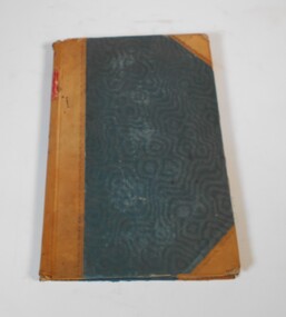
Book with greenish/blueish cover, brown leather spine and corners. The book covers land sales by auction for the years 1877 to 1898. The sales are listed under Town and County.On the spine red label with gold letters: "Reports of sales by auction" also on the spine in red texter the number 7, in black the letter E and 1877 to 1898land sales, auctions, 1877-1898 -
 Bendigo Historical Society Inc.
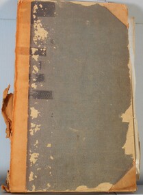
Legal record - Land Register
Land register for duration 1924 to 1951 (!!). Register contains plans of Land sales for a broad area of Central Victorian Parish / Counties. Register has a stiff blue card cover originally bound with light brown leather spine and corners, presently in a dire condition with cover damaged and loose; plans also folded and damaged. Plans inserted as drawn plans within the register, later plans are included on tracing, paper and linen - in various degrees of condition / damage.land register, central victoria -
 Bendigo Historical Society Inc.
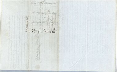
Legal record - Power of Attorney, 18/02/1862
Captain Mackenzie Luckie was born in 1821. From 1853 he commanded eight ships. He died on board the Michael Angelo off the coast of New Zealand in February 1875. After the ship arrived in Nelson, The Argus (Melbourne) reported on 12 February 1875 that Captain Luckie was found dead in his cabin, from heart disease. His appointed Attorney Mr George William Knight selected land in Sunbury in 1860 and then arrived in Bendigo on 2 April 1870. For more information about George William Knight see https://trove.nla.gov.au/newspaper/article/227853797?searchTerm=george%20william%20knightCaptain McKenzie Luckie a. Document appointing George William Knight of Sunbury or elsewhere in the Colony of Victoria as a lawful attorney to act for Mackenzie Luckie of 15 Tredegar Square, Bow in the County of Middlesex (now London), Master Mariner. Dated 18 February 1862. Witnessed by William Charles White. Five page document - two blue flimsy sheets, one light card sheet and two grey flimsy sheets. b. Transcript from The Age (Melbourne) 27 November 1937. The letter from H. Daniel, Monte Video, South America, is responding to an earlier letter from the grand daughter of Captain Mackenzie Luckie. It includes a record of the career of Captain Luckie from 1853. captain mackenzie luckie, master mariner -
 Bendigo Historical Society Inc.
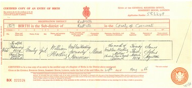
Certificate - HOSKING AND HUNKIN COLLECTION: BIRTH CERTIFICATE, 1854
HOSKING AND HUNKIN COLLECTION: Birth Certificate Certified copy of an entry of birth 1854 in the sub-district of Redruth in the County of Cornwell. For Emily Hosking, parents William Hosking and Emblem Hosking (Nancarrow)document -
 City of Greater Bendigo - Civic Collection
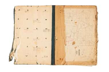
Administrative record - Land Sales, A. J. Mullet Government Printer et al, 1927
This type of album was made by agents auctioning and selling land.Large portfolio style album with dark green / black cloth cover bound with three large metal pins. Forty eight pages with twenty seven Department of Lands and Survey maps and newspaper clippings about land sales and auction details pasted in. Index page. Maps have handwritten notes and markings throughout in pencil and pen. Covers the County's of Gunbower and Tatchera. Includes a receipt slip with hand written notes on reverse on William Wallace & Co letterhead. city of bendigo commerce -
 Wodonga & District Historical Society Inc
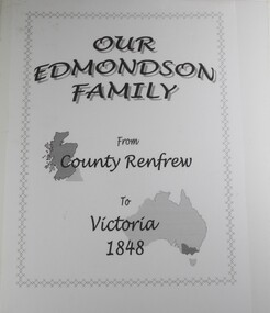
Book - Our Edmondson Family - from County Renfrew to Victoria 1848, Rob Mortlock, Bob Polkinghorne, Lorna Polkinghorne
This history of the Edmondson family begins with the journey of George and Isabella Edmondson, with their four children, from County Renfrew via Liverpool to Melbourne in 1848. After some time at the Bendigo goldfields, George and his second wife, Margaret Boyd, moved to the Yackandandah area. Later family members settled in various areas of Victoria, with one descendant, Ern Edmondson being a member of the ANZAC forces. Particular mention is made of Maud Cadman, an octogenarian family member, and source of much family information. The story is profusely illustrated with photographs of family members, and, in particular, a photograph of a New Testament, presented to Margaret Boyd aboard the ship that brought her to Australia in 1852.non-fictionThis history of the Edmondson family begins with the journey of George and Isabella Edmondson, with their four children, from County Renfrew via Liverpool to Melbourne in 1848. After some time at the Bendigo goldfields, George and his second wife, Margaret Boyd, moved to the Yackandandah area. Later family members settled in various areas of Victoria, with one descendant, Ern Edmondson being a member of the ANZAC forces. Particular mention is made of Maud Cadman, an octogenarian family member, and source of much family information. The story is profusely illustrated with photographs of family members, and, in particular, a photograph of a New Testament, presented to Margaret Boyd aboard the ship that brought her to Australia in 1852.edmondson family, pioneers, beechworth, yackandandah, northeast victoria family history -
 Bendigo Historical Society Inc.
Document - LANDS OFFICE - SALE OF CROWN LANDS - 1864 - 1869, 1864- 1869
Journal: LANDS OFFICE - SALE OF CROWN LANDS - 1864 - 1869 Brown hard cover journal. Contains details of sales of crown land, listed in chronological order of sales. Includes lot, allotment, section, county, parish, area, upset price per acre, deposit, amount for which sold, valuation, name of purchaser. On spine 011Lands Officelands office, crown land, crown land sales, land sales, bendigo, sandhurst -
 Bendigo Historical Society Inc.
Document - LANDS OFFICE, REPORTS OF SALES BY PUBLIC AUCTION, 1864 - 1892
Document: buff leather hard covered journal. On spine on red rectangle ' Land sales by public auction' written in gold. On bottom of spine 'Lands and Survey' written in gold on black. On base of spine '4' printed in black. Pages contain details of sales of crown lands by public auction Act 25, Victoria 145. Alphabetical index of counties inside front cover. 443 numbered pages. LH side columns, number, county, parish, section, allotment sold, unsold, price. RH page - improvements, purchaser, residence, amount, later sales have printed notices pasted in. Dated 27 April 1864 to 7 October 1892.Lands and Survey Dept.place, bendigo, sandhurst, crown land, public land auctions, land sales. -
 Bendigo Historical Society Inc.
Document - MISS G ALICE JONES COLLECTION: ACCOUNT
Bendigo Amalgamated Gold Fields Ltd. To Miss G. Alice Jones. Re You V Geo Lakey - County court Summons £59.18.3. Scale C, Sale to Ennor. To Osgood, Land Tax, You V Brauman C. C. S. No. 27 (Special) Scale D £137.1.7, You V Brauman C.C.S. No. 38 (Ordinary), You V Brauman C.C.S. 1924 No. 43 (Special) £137.1.7., Clarence Freeholds-Sale to Bowden, Sea Co. Machinery & Freehold land, Land transferred from New Vic. Catherine Co., re Koch's Pioneer G.M. Co. N.L. transfer of G.M. Lease No 9791 Bendigo, re North Ulster G.M. Co. N.L. transfer of G.M Lease No. 9789 Bendigo. Details of costs and dates varying from June 28, 1923, to March 30, 1925.Also dated 3/6/25 and Pd 30/7/25.the miss g. alice jones collection - account, bendigo amalgamated goldfields ltd, geo lakey, mr stanfield, mr jn smalley, mr thomson, mr crow, mr ennor, osgood, mylon, mrs murdock, constable thomson, brauman, mr miller, melbourne sun, clarence freeholds, j h curnow & son, gazette, sea co, mr legge, mr skews, h m legge & co, new vic catherine co, koch's pioneer g m co nl, north ulster g m co nl, g m lease no 9789 bendigo -
 Bendigo Military Museum
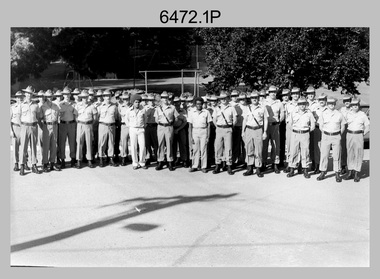
Photograph - Lithographic Squadron with DCP Students, Army Survey Regiment, Fortuna Villa, Bendigo, 1985
This is a set of six photographs of Lithographic Squadron personnel with Defence Cooperation Program (DCP) students at the Army Survey Regiment, Fortuna Villa, Bendigo Victoria, 1985. These informal and formal group photos were taken on the day of a CO’s Parade. Litho Squadron provided printing and photographic reproduction to the two DCP students. RA Svy also provided technical training to DCP students in map production skills such as, cartography and photogrammetry at the Army Survey Regiment and the School of Military Survey, Bonegilla. The Australian Defence Force over several years sponsored international students from counties such as Indonesia, Malaysia, Papua New Guinea, Philippines, Solomon Islands and Vanuatu. It is not known which South Pacific country these DCP students came from.This is a set of six photographs of Lithographic Squadron personnel with Defence Cooperation Program (DCP) students at the Army Survey Regiment, Fortuna Villa, Bendigo Victoria, 1985. The photographs are on 35mm negative film and were scanned at 96 dpi. They are part of the Army Survey Regiment’s Collection. .1) Photo, black & white, 1985. L to R: Warren ‘Waldo’ Shirley, Per Andersen, Trevor Osborne, Roy Hicks, Lance Strudwick, Steve Burke, Dale Hudson, Paul Baker, Ralph Chant, Peter Breukel, John ‘Flash’ Anderson, Chad Hardwick, Peter Imeson, DCP student John or Henry, unidentified, Greg Rowe, John South, unidentified, Mick ‘Buddha’ Ellis, John ‘Junior’ Whaling, Terry King, Daryl South, DCP student John or Henry, Bronwyn Jones, John Bateman, Kerron South, unidentified officer, Peter Dillon, Kim Reynolds, Rob Jones, unidentified, Jeff Lynch, Garry Hudson, Mark ‘Dogs’ Doherty, Jim Ash, Gavin Neilson, Jeff Willey, unidentified, Graham Johnston, Steve Egan, Peter Barrett, George Austen, Dave Miles. .2) - Photo, black & white, 1985. L to R: Warren ‘Waldo’ Shirley, Per Andersen, Trevor Osborne, Roy Hicks, Lance Strudwick, Steve Burke, Dale Hudson, Paul Baker, Ralph Chant, Peter Breukel, John ‘Flash’ Anderson, Chad Hardwick, Peter Imeson, DCP student John or Henry, unidentified, Greg Rowe, John South, unidentified, Mick ‘Buddha’ Ellis, John ‘Junior’ Whaling, Terry King, Daryl South, DCP student John or Henry, John Bateman, Kerron South, unidentified officer, Peter Dillon, Kim Reynolds, Rob Jones, unidentified, Jeff Lynch, Garry Hudson, Mark ‘Dogs’ Doherty, Jim Ash, Gavin Neilson, Jeff Willey, unidentified, Graham Johnston, Steve Egan, Peter Barrett, Dave Miles, George Austen. .3) - Photo, black & white, 1985. Photo Troop L to R: Steve Burke, Garry Hudson, Warren ‘Waldo’ Shirley, Ralph Chant, Gavin Neilson, DCP student John or Henry, Paul Baker, Trevor Osborne, Peter Imeson, Mick ‘Buddha’ Ellis, unidentified, John ‘Junior’ Whaling, DCP student John or Henry, Chad Hardwick, Terry King, Dave Miles, Graham Johnston, Kerron South, Bronwyn Jones, Rob Jones, unidentified. .4) - Photo, black & white, 1985. L to R: WO1 Jeff Lynch, DCP student John or Henry, CAPT John South, unidentified officer, DCP student John or Henry, WO2 Dave Miles. .5) & .6) - Photo, black & white, 1985. Print Troop L to R: Per Andersen, Daryl South, Lance Strudwick, Peter Dillon, DCP student John or Henry, Jeff Willey, John Bateman, Roy Hicks, Paul Davis, Dale Hudson, Kim Reynolds, Greg Rowe, Jim Ash, DCP student John or Henry, Mark ‘Dogs’ Doherty, Peter Breukel, Peter Barrett, unidentified, unidentified officer, Steve Egan, George Austen.No personnel are identified. Date and DCP students noted on film negative sleeve.royal australian survey corps, rasvy, army survey regiment, army svy regt, fortuna, asr, litho sqn, litho -
 Bendigo Historical Society Inc.
Document - LANDS OFFICE: CROWN LAND SALES 1855 - 1857, 1855 - 1857
Document: LANDS OFFICE: CROWN LAND SALES 1855 - 1857 brown hard covered journal with buff corners and spine. Contains 200 pages with details of crown land sales. LH page: lot, sec., allotment, county, parish, area, upset price, deposit, amount RH page: val. name of purchaser, name of owner of improvement, remarks.Lands Officeland sales 1855 - 57, lands office, sandhurst, bendigo, land sales, crown land