Showing 537 items
matching horse-drawn vehicles
-
 Marysville & District Historical Society
Photograph (Item) - Black and white photograph, Yarra Track Hotel, c1900
... ), and was designed to accommodate horse-drawn vehicles. The Track involved ...An early black and white photograph of a hotel along the Yarra Track.An early black and white photograph of a hotel along the Yarra Track. The Yarra Track is the former name of the gold fields road from Healesville to the Woods Point and Jordan Goldfields, in Victoria, Australia. A direct route via the Yarra River and the Great Divide was discovered by Rieck in September 1862 and became known as the Yarra Track. Early in 1863, the Victorian Government decided to construct a 193-kilometre (120 mile) road along the route. Its original width varied between 4 and 6 metres (12 and 20 feet), and was designed to accommodate horse-drawn vehicles. The Track involved the climbing of the Black Spur, descent into the Acheron Valley, and then through Marysville to the Cumberland where it followed the existing route. Unable to ascertain both the location and name of hotel.ARMSTRONG COLLECTION 42 STATION STREET/ SANDRINGHAM 3191/ TEL. (03) 9521 5442/ IAN M.L. ARMSTRONG OAMyarra track, healesville, wood's point, jordan goldfields, victoria, yarra river, great divide, reick, black spur, acheron valley, marysville, cumberland creek -
 Marysville & District Historical Society
Photograph (Item) - Black and white photograph, The "Scandinavians' - (Deserted), c1900
... ), and was designed to accommodate horse-drawn vehicles. The Track involved ...An early black and white photograph of The Scandinavian's Hotel and Boarding House along the Yarra Track.An early black and white photograph of The Scandinavian's Hotel and Boarding House along the Yarra Track. The Yarra Track is the former name of the gold fields road from Healesville to the Woods Point and Jordan Goldfields, in Victoria, Australia. A direct route via the Yarra River and the Great Divide was discovered by Rieck in September 1862 and became known as the Yarra Track. Early in 1863, the Victorian Government decided to construct a 193-kilometre (120 mile) road along the route. Its original width varied between 4 and 6 metres (12 and 20 feet), and was designed to accommodate horse-drawn vehicles. The Track involved the climbing of the Black Spur, descent into the Acheron Valley, and then through Marysville to the Cumberland where it followed the existing route.ARMSTRONG COLLECTION 42 STATION STREET/ SANDRINGHAM 3191/ TEL. (03) 9521 5442/ IAN M.L. ARMSTRONG OAMthe scandinavians', yarra track, healesville, wood's point, jordan goldfields, victoria, yarra river, great divide, reick, black spur, acheron valley, marysville, cumberland creek -
 Marysville & District Historical Society
Photograph (Item) - Black and white photograph, Camp Opposite The "Scandinavians', c1900
... ), and was designed to accommodate horse-drawn vehicles. The Track involved ...An early black and white photograph of a camp which was opposite The Scandinavian's Hotel and Boarding House along the Yarra Track.An early black and white photograph of a camp which was opposite The Scandinavian's Hotel and Boarding House along the Yarra Track. The Yarra Track is the former name of the gold fields road from Healesville to the Woods Point and Jordan Goldfields, in Victoria, Australia. A direct route via the Yarra River and the Great Divide was discovered by Rieck in September 1862 and became known as the Yarra Track. Early in 1863, the Victorian Government decided to construct a 193-kilometre (120 mile) road along the route. Its original width varied between 4 and 6 metres (12 and 20 feet), and was designed to accommodate horse-drawn vehicles. The Track involved the climbing of the Black Spur, descent into the Acheron Valley, and then through Marysville to the Cumberland where it followed the existing route.ARMSTRONG COLLECTION 42 STATION STREET/ SANDRINGHAM 3191/ TEL. (03) 9521 5442/ IAN M.L. ARMSTRONG OAMthe scandinavians', yarra track, healesville, wood's point, jordan goldfields, victoria, yarra river, great divide, reick, black spur, acheron valley, marysville, cumberland creek -
 Marysville & District Historical Society
Document (Item) - Research Document, Judith Vimpani, William Cavanagh Farrell (1844-1901), 04-2020
... ), and was designed to accommodate horse-drawn vehicles. The Track involved ...An account of the life of William Cavanagh Farrell.An account of the life of William Cavanagh Farrell who was important to Marysville as his review in 1863 of the routes to Wood's Point led to the Yarra Track ascending the Black Spur and going on to what became the resort town of Marysville on the Steavenson River. The Yarra Track is the former name of the gold fields road from Healesville to the Woods Point and Jordan Goldfields, in Victoria, Australia. A direct route via the Yarra River and the Great Divide was discovered by Reick in September 1862 and became known as the Yarra Track. Early in 1863, the Victorian Government decided to construct a 193-kilometre (120 mile) road along the route. Its original width varied between 4 and 6 metres (12 and 20 feet), and was designed to accommodate horse-drawn vehicles. The Track involved the climbing of the Black Spur, descent into the Acheron Valley, and then through Marysville to the Cumberland where it followed the existing route.willaim cavanagh farrell, marysville, victoria, wood's point, yarra track, black spur, steavenson's creek, steavenson river, george theodore rieck -
Marysville & District Historical Society
Document (Item) - Research Document, Judith Vimpani, George Theodore Rieck (1833-pos 1884), 04-2020
... -drawn vehicles. The Track involved the climbing of the Black ...An account of the life of George Theodore Rieck.An account of the life of George Theodore Rieck. The Yarra Track is the former name of the gold fields road from Healesville to the Woods Point and Jordan Goldfields, in Victoria, Australia. A direct route via the Yarra River and the Great Divide was discovered by Rieck in September 1862 and became known as the Yarra Track. Early in 1863, the Victorian Government decided to construct a 193 kilometre (120 mile) road along the route. Its original width varied between 4 and 6 metres (12 and 20 feet), and was designed to accommodate horse-drawn vehicles. The Track involved the climbing of the Black Spur, descent into the Acheron Valley, and then through Marysville to the Cumberland where it followed the existing route.george theordore rieck, marysville, victoria, james murphy, new chum creek, wood's point, gold mining, matlock, walhalla, yarra track -
Marysville & District Historical Society
Booklet (Item) - Information booklet, Artworkz Tourism, The Big Culvert, Unknown
... and 20 feet), and was designed to accommodate horse-drawn ...An information booklet that was produced as a guide to The Big Culvert.An information booklet that was produced as a guide to The Big Culvert. The Big Culvert is a historic granite and bluestone arch along the Yarra Track, a major route to Melbourne through the 1800s. Built in 1870 and a major piece of infrastructure for its time, the heritage listed culvert allowed water to flow under often-flooded the road. The Yarra Track is the former name of the gold fields road from Healesville to the Woods Point and Jordan Goldfields, in Victoria, Australia. A direct route via the Yarra River and the Great Divide was discovered by Rieck in September 1862 and became known as the Yarra Track. Early in 1863, the Victorian Government decided to construct a 193-kilometre (120 mile) road along the route. Its original width varied between 4 and 6 metres (12 and 20 feet), and was designed to accommodate horse-drawn vehicles. The Track involved the climbing of the Black Spur, descent into the Acheron Valley, and then through Marysville to the Cumberland where it followed the existing route.the big culvert, yarra track, victoria, healesville, wood's point goldfields, jordan goldfields, black spur, acheron valley, cumberland valley -
Marysville & District Historical Society
Flyer (Item) - Information flyer, Artworkz Tourism, The Big Culvert, 26-03-2016
... ), and was designed to accommodate horse-drawn vehicles. The Track involved ...An information flyer that was produced as a guide to The Big Culvert.An information flyer that was produced as a guide to The Big Culvert. The Big Culvert is a historic granite and bluestone arch along the Yarra Track, a major route to Melbourne through the 1800s. Built in 1870 and a major piece of infrastructure for its time, the heritage listed culvert allowed water to flow under often-flooded the road. The Yarra Track is the former name of the gold fields road from Healesville to the Woods Point and Jordan Goldfields, in Victoria, Australia. A direct route via the Yarra River and the Great Divide was discovered by Rieck in September 1862 and became known as the Yarra Track. Early in 1863, the Victorian Government decided to construct a 193-kilometre (120 mile) road along the route. Its original width varied between 4 and 6 metres (12 and 20 feet), and was designed to accommodate horse-drawn vehicles. The Track involved the climbing of the Black Spur, descent into the Acheron Valley, and then through Marysville to the Cumberland where it followed the existing route.the big culvert, yarra track, victoria, healesville, wood's point goldfields, jordan goldfields, black spur, acheron valley, cumberland valley -
 Marysville & District Historical Society
Photograph (Item) - Black and white photograph, Unknown
... ), and was designed to accommodate horse-drawn vehicles. The Track involved ...A black and white photograph taken at the unveiling of the sign placed at The Big Culvert.A black and white photograph taken at the unveiling of the sign placed at The Big Culvert. The Big Culvert is a historic granite and bluestone arch along the Yarra Track, a major route to Melbourne through the 1800s. Built in 1870 and a major piece of infrastructure for its time, the heritage listed culvert allowed water to flow under often-flooded the road. The Yarra Track is the former name of the gold fields road from Healesville to the Woods Point and Jordan Goldfields, in Victoria, Australia. A direct route via the Yarra River and the Great Divide was discovered by Rieck in September 1862 and became known as the Yarra Track. Early in 1863, the Victorian Government decided to construct a 193-kilometre (120 mile) road along the route. Its original width varied between 4 and 6 metres (12 and 20 feet), and was designed to accommodate horse-drawn vehicles. The Track involved the climbing of the Black Spur, descent into the Acheron Valley, and then through Marysville to the Cumberland where it followed the existing route.Unveiling of sign/ at "Big Culvert" In front Max Cockerrell and - Rear: second back Geoff Pope R.H.S. rear: Nancy "/ Anne "the big culvert, yarra track, victoria, healesville, wood's point goldfields, jordan goldfields, black spur, acheron valley, cumberland valley -
 Marysville & District Historical Society
Photograph (Item) - Colour photograph, 20-09-2008
... ), and was designed to accommodate horse-drawn vehicles. The Track involved ...A colour photograph of the entrance to The Big Culvert.A colour photograph of the entrance to The Big Culvert. The Big Culvert is a historic granite and bluestone arch along the Yarra Track, a major route to Melbourne through the 1800s. Built in 1870 and a major piece of infrastructure for its time, the heritage listed culvert allowed water to flow under often-flooded the road. The Yarra Track is the former name of the gold fields road from Healesville to the Woods Point and Jordan Goldfields, in Victoria, Australia. A direct route via the Yarra River and the Great Divide was discovered by Rieck in September 1862 and became known as the Yarra Track. Early in 1863, the Victorian Government decided to construct a 193-kilometre (120 mile) road along the route. Its original width varied between 4 and 6 metres (12 and 20 feet), and was designed to accommodate horse-drawn vehicles. The Track involved the climbing of the Black Spur, descent into the Acheron Valley, and then through Marysville to the Cumberland where it followed the existing route.the big culvert, yarra track, victoria, healesville, wood's point goldfields, jordan goldfields, black spur, acheron valley, cumberland valley -
 Marysville & District Historical Society
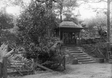
Photograph (Item) - Black and white photograph, John William Lindt, 1910
... . Visitors to the Hermitage alighted from horse-drawn vehicles ...A digital copy of an early black and white photograph of the entrance gate to "The Hermitage" at Narbethong in Victoria.A digital copy of an early black and white photograph of the entrance gate to "The Hermitage" at Narbethong in Victoria. "The Hermitage" was built by photographer John William Lindt as a home and guesthouse in 1894. John Lindt had previously photographed the mountain scenery of the Black Spur and purchased 71 acres and subseqently built his home and guesthouse from where he continued his career. "The Hermitage had a garden designed by John Lindt's friend, Ferdinand von Mueller, who was at one stage the Director of the Melbourne Botanic Gardens. The garden featured New Guinea tree houses from which John Lindt made frequent panoramas of his property and the surrounding forest of towering mountain ash. Aged 81 Lindt died of heart failure during disastrous bushfires on 19 February 1926 at the Hermitage. He was survived by his wife Catherine who continued to run ‘The Hermitage’ guest house before she retired to the city. Visitors to the Hermitage alighted from horse-drawn vehicles and later motor coaches to enter the estate through the lich-gate in the background.the hermitage, john william lindt, narbethong, victoria, black spur, ferdinand von mueller, melbourne botanic gardens, new guinea, catherine lindt -
 Blacksmith's Cottage and Forge
Book, Day, Day Book, 20 January 1920 to 27 April 1921
... to shoeing horses, repairs to horse drawn vehicles, repairs to farm ...This book contains information relating to daily work conducted by Charles Edwards, Blacksmith, during period 20th January 1920 to 27 April 1921. It lists customer names, types of work done and costs involved. The written X indicates whether work was paid in full.This books contains historical information relating to peoples names and industries in the Bacchus Marsh district and the work performed for them by the blacksmith during the period mentioned. Most of work relates to shoeing horses, repairs to horse drawn vehicles, repairs to farm machinery/tools and some work on cars.Cardboard covers - green marbled design with black spine. Account type book with red ruled columns. Hand written names, jobs, charges and dates.On the inner cover - Mrs C Edwards, Main Street, Bacchus Marshbook, blacksmith, day, customers, clients, charles edwards -
 Flagstaff Hill Maritime Museum and Village
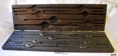
Tool - Taps and Dies set, Wiley and Russell Mfg. Co, C. 1884
... cart parts jinker buggy transport vehicle horse drawn horse ...This set of taps and dies tools was owned by Frederick William McDowell (Fred) (1880 to 15-6-1967). He was a wheelwright by trade. He made and repaired vehicles such gigs, buggies, jinkers, sulkeys, spring carts and farm wagons. His workshop was on the corner of Cramer Street and Raglan Parade in Warrnambool., previously the site of Fotheringhams, and after McDowell's, and still in 2023, occupied by Reece Plumbing Fred's workplace prior to retiring was at Bryant & Waterson's in Kepler Street, opposite the Criterian Hotel, making rubber tyred horse-driven farm wagons. This Wiley and Russell hand operated, thread cutting Die and Stock, or Die and Tap, set’s patent carries the description “The taper-headed screws adjust the size; the four side screws hold the cutters firmly in the holder. Marketed as the Wiley & Russell LIGHTNING SCREW PLATE. The taper-headed screws are carried over from the J.J. Grant October 21, 1871 patent (no. 120,266). This patent was improved by Smart's Oct. 21, 1884 patent (no. 306,783).” Dies are used to cut external screw thread, stocks are the tools that hold the dies in place with countersunk adjustable screws, and taps are the tools that make the internal threads. The tools would be used by farriers, blacksmiths, wheelwrights sailing and steam ship engineers for making new, or repairing old, threads in metal. WILEY AND RUSSELL Manufacturing Company The company Wiley and Russell was established in 1872 by Solon Wiley and Charles P Russell, whose uncle founded the J. Russell Cutlery Co. The company began with the purpose of manufacturing thread cutting tools in Green River U.S. This tap and die set is an example of tools used by blacksmiths, farriers, wheelwrights and engineers on sailing and steam ships. It is also an example of early U.S. made engineering tools.Tap, Die, Die Stock set of industrial tools, fitted inside original timber box with three instruction labels attached inside lid. The set is the “Wiley and Russell LIGHTNING SCREW PLATE Pat. Aug. 5, 1884”. The lid has three metal hinges and is secured by two metal hook and eye fittings. This set of Whitworth standard threads has metal die and stocks (seven), and taps (three - the case has provision for four more die). The manufacturer’s details and the sizes of the threads are impressed into the tools. The paper labels have instructions and a diagram for the use and care of the tools. Tools have a protective oil coating. Made by Wiley and Russell Manufacturing Co. of Greenfield, Massachusetts, U.S., c. 1884; the tools were patented in August 1884, U.S. Patent 303,060. “Wiley & Russell MFG.CO, Greenfield, Mass, Pat Aug 5 1884.” “WHIT. STD.”flagstaff hill, warrnambool, shipwrecked coast, flagstaff hill maritime museum, maritime museum, shipwreck coast, flagstaff hill maritime village, great ocean road, tap and die set, 1884 engineering tools, wiley and russell mfg co, lightning tap and die set, tap, die and stock set, screw thread cutting tools, taps and dies, stocks and dies, lightning screw plate, cutters, j.j. grant, patent no. 120266, solon wiley and charles p russell, wiley and russell, j. russell cutlery co, green river u.s, whitworth thread, fred mcdowell, frederick mcdowell, wheelwright, gig, buggy, jinker, sulkey, spring cart, farm wagon, 2-wheeled cart, horse cart, horse cart parts, jinker buggy, transport, vehicle, horse drawn, horse jinker, bryant & waterson -
 Flagstaff Hill Maritime Museum and Village
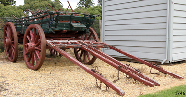
Vehicle - Wagon, Early 20th Century
... were transported using horse-drawn vehicles at the beginning ...This wagon is linked to Mr Stanley James Bell via his father Mr John Bell, who owned "Warrumyea" at Wangoom. It is believed that Stanley grew up and worked for his father at this property, eventuality inheriting his father's death in 1920. This wagon was likely used at Mr Stanley Bell's property “Warrumyea” at Wangoom around 1920-1940. The wagon was donated in 1984, at which time it was noted as having a brass plate inscribed "Jas", which name Stanley was known by. Also, a painted on the wage was “S J Bell Wangoom”. Remnants of the original paint colours of blue and yellow show on the photograph, which was taken at the time of cataloguing. Mr John Bell Snr from Plymouth, England, arrived in Portland, Victoria, around 1860. He had served in the British navy as a lad for a number of years. On arriving in Australia he travelled to the Wangoom district where he lived for many years. Mr J Bell worked for 20 years as herd manager at “Wangoom Park”., for Mr F Tozer (1843-1954), one of the original pioneers of the western district. He went on to pursue dairying and general farming at his property “Warrumyea” Wangoom. Bell’s son Stanley James Bell went to the Wangoom School. His first reader from this school, published in 1909, has his name inscribed in the flyleaf “Stanley J. Bell, Warrumyea, Wangoom” and is now in the collection of the Warrnambool & District Historical Society. Stanley went on working the property “Warrumyea” and eventually purchased “Wangoom Park” in 1956, where his father had been employed years before. Mr S J Bell died in 1968.The wagon is significant for its association with the farming history of Wangoom and the Warrnambool area in general. Also, the wage is significant for its association with one of the early families that settled in the Warrnambool area and their contribution to the dairying and general farming industries that sprang from their efforts. The wagon has a good provenance linking it to Mr Stanley James Bell and is also a good example of how goods were transported using horse-drawn vehicles at the beginning of the 20th century.Four-wheeled wagon or cart,12 spokes in each wheel, wooden axle with rear hub brake. Hinged and chained tailboard. Wheels have metal rims. Metal frame and wooden superstructure. Wagon has two pairs of staves. Wooden shelves, one missing with turntable. Small toolbox in front. Made by Kelly and Preston of Ballarat. Metal nameplate of the owner attached, "Jas" (S J Bell of Wangoom).. Original inscription, now obscured, was painted “Kelly and Preston Builders Ballarat”. Metal plate inscribed "Jas", and "S J Bell Wangoom". flagstaff hill, warrnambool, shipwrecked-coast, flagstaff-hill, flagstaff-hill-maritime-museum, maritime-museum, shipwreck-coast, flagstaff-hill-maritime-village, wagon, sj bell, stanley james bell, wangoom park, warrumyea, first reader, john bell 1830-1920, stanley james bell 1904-1968, warrnambool pioneers, f tozer, western district, kelly and preston of ballarat -
 Flagstaff Hill Maritime Museum and Village
Wagon
... horse drawn vehicle... horse drawn vehicle "S J Bell Wangoom" Wagon, four wheeled fully ...Wagon, four wheeled fully sprung with tail board, railing on each side plus hand operated brake on rims of rear wheels. Wooden frame, metal turntable and single shalves. Double chain for harness attached to wooden tail piece. Metal rimmed wheels. Wagon once belonged to S.J. Bell, Wangoom"S J Bell Wangoom"flagstaff hill, warrnambool, shipwrecked-coast, flagstaff-hill, flagstaff-hill-maritime-museum, maritime-museum, shipwreck-coast, flagstaff-hill-maritime-village, cart, wagon, horse drawn vehicle -
 City of Moorabbin Historical Society (Operating the Box Cottage Museum)
Photograph - Plateway (Wheelway) Steel, circa 1885
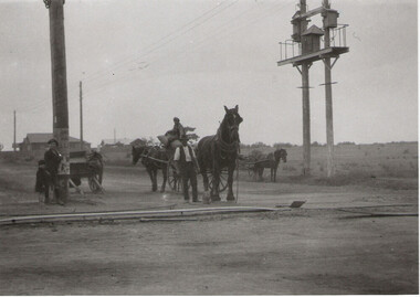
By the later 1800s the dirt roads in the then out-lying areas of the City of Moorabbin became dangerous, and almost impassable due to huge potholes and muddy swampy areas. The heavily laden market gardener’s carts regularly broke axles and wheels, and horses foundered on their way to the Melbourne markets. Even worse, the heavier “iron maidens”, carrying their malodorous loads of sewage from Melbourne’s inner suburbs for dumping in the outlying areas of the City of Moorabbin, also got bogged in the mire. It was decided that a practical solution to this problem was to install a metal plateway on the side of the problematic roads. In about 1887 the Moorabbin Shire Centre Road, in the Brighton East area, two parallel metal rails were installed so that the wheels of carts could run along smoothly, the horse travelled in the filled, middle area between the rails. Point Nepean Road plateway was removed in 1930 and Centre Dandenong Road plateway was removed in 1934-35. The worn plateway along Centre Road, East Brighton (now known as Bentleigh), was gradually taken up in several pieces, commencing in the the1920s, when its condition deteriorated and it caused a hazard to bikes, pedestrians, motor-cycles and the few early cars. The early steel plateway, constructed by David Munro, and opened on 23rd March 1885 by Thomas Bent, was built along Nepean Highway, between Asling St. and Bay St. The Point Nepean Track was subsequently extended into Moorabbin with branches along Centre, Cumins, South, Wickham, and Keys Roads, the total length was 13 miles. In 1908-1909 plates were laid along Centre Dandenong Road to Ross Street Bentleigh This innovative solution proved successful and was used until gradually the main roads were upgraded, and motorised vehicles started to appear. Two parallel metal rails were installed in the right hand side of a few main roads in the Shire of Moorabbin so that the wheels of heavily-loaded market gardener's carts on their way to markets in Melbourne could run along smoothly. The horse pulling the carts travelled in the filled, middle area between the rails. The Steel Plateway was constructed by David Munro, and opened on 23rd March 1885 by Thomas Bent. The wheelway first only ran along Nepean Highway, but it soon extended from Centre Dandenong Road, along Nepean road to its junction with Chapel Street, St Kilda. Later branch lines were built along Centre Road, Bentleigh as far as Warrigal Road and, according to early photographs, along Wickham Road Moorabbin as well. This innovative solution proved successful and was used until gradually the main roads were upgraded, and motorised vehicles started to appear. There was a problem with the wheelway : there was only a single set of rails and this was established on the right-hand side of the Nepean Road, travelling towards the city. Traffic FROM the city travelled on the correct or left-hand side of the road. The exception to this rule was the malodorous iron-clads, heavily riveted iron carts, generally travelling in convoy, carrying several tons of human effluent out of Melbourne to be trenched-in in the sandy soil of the Moorabbin district. Moorabbin City Council donated and installed a small section of Plateway at Box Cottage Museum in 1984melbourne, brighton, moorabbin, roads, plateway, wheelway, transport, st kilda, bent thomas, munro david, market gardens, steelway, carts horse-drawn, iron maidens, point nepean track -
City of Moorabbin Historical Society (Operating the Box Cottage Museum)
Tools, Wagon Wheel Spanner c1900, c1900
Among the early settlers in Moorabbin Shire were blacksmiths who made tools for the other settlers who were establishing the homes, market gardens, farms, orchards and various businesses. Early settlers were self reliant and repaired their own equipment for kitchen,dairy, farm, horses, wagons, carts using various tools . These large spanners were used on a horse-drawn wagons, carriages, stagecoaches, and carts. A wheelwright would use this tool to make or repair the wheels. All sizes of buggy spanners, or wagon wrenches, were needed as wagon wheels were of many different sizes. This wagon wheel spanner is typical of the type used by early settlers in Moorabbin Shire c1900 Horse-drawn wagons were used to transport the produce of the market gardeners to the Melbourne markets. Buggies, Traps and Jinkers were popular with farmers, Doctors, and Councillors for trips into town before the advent of the motorized vehicles.A steel wheel wrench, spanner for wagon wheels. c1900 wagons, wheelwrights, spanners, iron rimmed wheels , early settlers, market gardeners, blacksmiths, tools, building equipment, hammers, moorabbin shire, bentleigh, mckinnon, highett, cheltenham,mcewan james pty ltd, melbourne, bunnings pty ltd, -
 Bendigo Historical Society Inc.
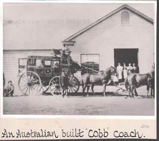
Photograph - COBB & CO., AN AUSTRALIAN BUILT 'COBB' COACH
black and white image ( copy ) : image shows Cobb & Co., coach, passengers, men up front, team of horses. Coach is standing in front of weatherboard building, large open doorway, four men standing in it. On bottom : An Austrralian built 'Cobb' coach. / Sign on roof states 'Cobb & Co Ltd Coach & Buggy Builders .- Coachworks were established in Bathurst, Bourke, Goulburn, Hay and Charleville, business boomed and the name of ‘Cobb & Co’ became the byword for cutting edge communications and transport facilities across eastern Australia.''Cobb & Co Factories Shortly after its arrival in Bathurst, Cobb & Co established the first of five coach works, both to supply its own transportation and as a commercial venture. The factory was situated at the Black Bull Inn, on the corner of Howick and Bentinck Streets, and a variety of prize-winning horse-drawn conveyances were built on the site (including an unsuccessful single-wheel vehicle to cater for rough and steep country). The factory was transferred to new premises in William Street in 1876, by which time Cobb & Co factories were also operating in Hay, Goulburn and Bourke in New South Wales and at Charleville in Queensland.///The horses are wearing blinkersbusiness, transport, cobb & co., cobb & co. -
 Bendigo Historical Society Inc.
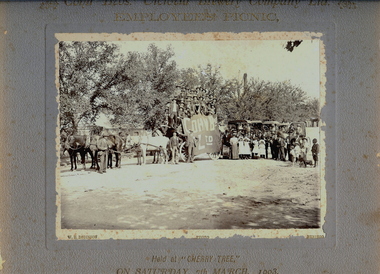
Photograph - COHN BROS. EMPLOYEES PICNIC, 7th March, 1903
Black and white photograph on grey board. Large number (approx 27) of males on 4 horse drawn wagon, buggies with passengers in background. Men, women and children standing at front. One male has a bass drum. Banner on side of vehicle reads 'Cohn Bros Ltd'. Trees in background. Tall chimney in distance. Inscriptions: Front - printed on mount board 'Cohn Bros Victoria Brewery Company Ltd, Employees Picnic, held at Cherry Tree on Saturday 7th March, 1903', WH Robinson Photo, Bendigo', On back - 'Royal Historical Society of Victoria, Bendigo Branch', '1959, 71'. Photograph missing from this file 6/05/2021.WH Robinson Photo, Bendigoperson, group, picnic group -
 Echuca Historical Society
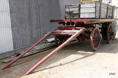
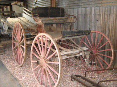
Horse Drawn Vehicle - Coal Box Buggy
... Horse Drawn Vehicle - Coal Box Buggy...-country Buggy or ..... Horse Drawn Vehicle - Coal Box Buggy ...Buggy or ..... -
 National Wool Museum
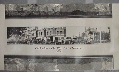
Photograph, Blakiston & Co Pty Ltd Carriers 1931
... , both horse drawn and motor, loaded and lined up outside..., both horse drawn and motor, loaded and lined up outside... vehicles, both horse drawn and motor, loaded and lined up outside ...A 1931 photograph of Blakiston & Co's carrier vehicles, both horse drawn and motor, loaded and lined up outside the Blakiston buildingA 1931 photograph of Blakiston & Co's carrier vehicles, both horse drawn and motor, loaded and lined up outside the Blakiston building.Blakiston & Co Pty Ltd Carriers/ 1931wool - transportation, blakistons limited -
 Yarrawonga and Mulwala Pioneer Museum
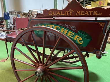
Vehicle - Butcher Delivery Cart, Purchased by Hicks Butchery Mulwala from Goulburn NSW
Belonged to our local butcher Delivered meat round the townWooden Cart Horse Drawn with long wooden shafts which has been restored“Pleased to meet you with meat to please you “. Butcher. Quality Meats -
 Whitehorse Historical Society Inc.
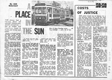
Newspaper - Article, Mural - Spencer St Station, 13/01/1978
Australia Day 1978 Melbourne had the biggest collection of historic vehicles seen in this country. There were electric and horse drawn trams, steam trains, veteran and vintage cars and even a fly past of old flying machines. Officially the occasion marked the unveiling of Harold Freeman's giant mural at Spencer Street Station depicting a century of transportation in Australia. Another paragraph refers to the horse trough referred to in E - C - 3 and research by Amy Bunker into the story of George Bills. It points out that the RSPCA emergency home in Burwood is the George Bills Rescue Centre.transport, freeman, harold, spencer street station, horse troughs, bills, george, royal society for the prevention of cruelty to animals, bunker, amy -
 Whitehorse Historical Society Inc.
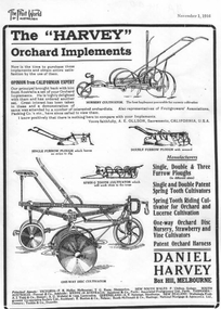
Vehicle - Cultivator
Large horse drawn six and four blade one - way disc cultivator with adjustment for angle of cultivation. Left hand wheel had a hub which a belt could be attached. (use??)|Cost about 45/10/0 (pound Australian) in 1928.rural industry, orcharding -
 Dandenong/Cranbourne RSL Sub Branch
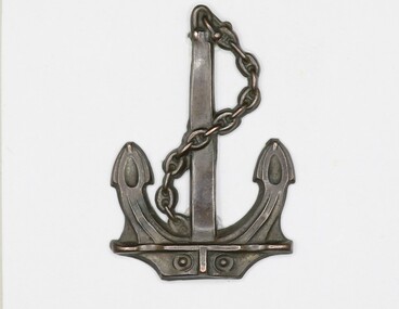
Badge - RAN Bridging Train Collar Badge, Circa 1914/15
The 1st Royal Australian Naval Bridging Train (1st RANBT) was formed in Melbourne on 28 February 1915 and was intended to be a horse drawn engineering unit attached to the Royal Naval Division (RND), then serving as infantry on the Western Front. The term ‘train’, in its title, was a direct reference to the horse drawn wagons that would, in theory, form and move ‘in train’ to carry the unit’s heavy lumber, building materials and engineering equipment to the front. The unit was manned by members of the Royal Australian Naval Reserve for whom there were no available billets in seagoing RAN ships. Many of the sailors serving in the 1st RANBT were rated ‘drivers’, and again, this refers to wagon drivers as opposed to motor vehicle drivers. Other seamen were rated as ‘artificers’ or ‘sappers’, the latter being a military term traditionally used to describe army engineers. Appointed in command of the 1st RANBT was Lieutenant Commander Leighton Seymour Bracegirdle, RAN. Bracegirdle was ideally suited to command the unit, having seen active service with the NSW Naval Brigade during the Boxer Rebellion in China as well as serving as a military officer in the South African Irregular Horse during the Boer War in 1901. He had also recently returned from German New Guinea where he had served as a staff officer in the joint Australian Naval and Military Expeditionary Force (ANMEF) responsible for the capture of the German colonies in the Pacific in September 1914. Three hundred naval reservists, including 50 men who had recently served in New Guinea, were selected for the 1st RANBT and they began their training in horsemanship, engineering and pontoon bridging at the Domain in Melbourne. By late May 1915 a decision was made to send the unit to Britain to complete its training and then to join the RND on the Western Front. The plan, however, never eventuated. The complaints about the non-combatant work being done by the men had been raised in Federal Parliament and following consultation with the senior Australian officer in the Middle East, Lieutenant General Sir Harry Chauvel, a recommendation was made that the unit be disbanded and its men used as reinforcements for the AIF. Consequently, Lieutenant Commander Bracegirdle was advised that his unit was to be dispersed; its men transferring to the AIF or being returned to Australia for discharge. On 27 March 1917 the 1st RANBT was officially disbanded.Oxidised brass anchor shaped collar badge.ww1, world war 1, first world war, ranbt, ran bridging train, royal australian navy bridging train, collar badge -
 City of Ballarat Libraries
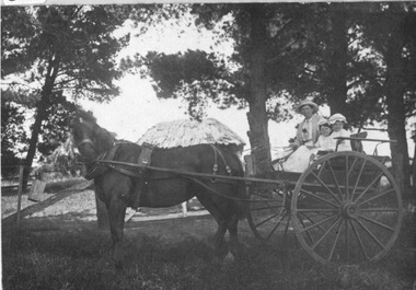
Photograph, Mrs May and daughters in horse drawn gig at Glendaruel circa 1905
glendaruel, may, vehicle, farm -
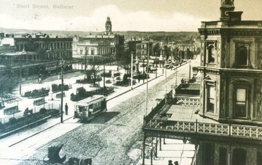
 City of Ballarat Libraries
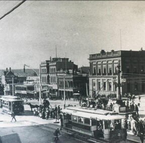
Photograph - Card Box Photographs, Sturt Street, Ballarat circa 1920
Sturt Street view looking south east from Lydiard Street North. You can see both electric trams and horse drawn cabs. The Mechanics' Institute can be seen in the background.sturt street, ballarat, electric tram, horse drawn cab, streetscape, building, commerical, vehicle -
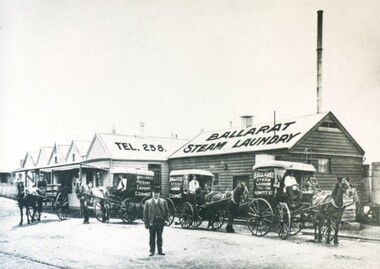 City of Ballarat Libraries
Photograph - Card Box Photographs, Ballarat Steam Laundry circa 1910
Proprietor of the Ballarat Steam Laundry, Carl Gottleib Heindrich Schmidt, stands outside the 821 Howitt Street premises along with 4 horse drawn delivery carts. ballarat steam laundry, carl gottleib heindrich schmidt, howitt street, commerical, building, vehicle -
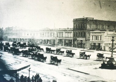 City of Ballarat Libraries
Photograph - Card Box Photographs, Horse Drawn Cab Rank, Ballarat circa 1870
Some of the businesses that can be seen are M.P. Whiteside (Tailor) and Alex Marks & Co. The Burke & Wills monument can also be seen.horse drawn cab, ballarat, sturt street, burke & wills monument, vehicle, streetscape, commerical, m.p. whiteside, alex marks & co. -
 City of Ballarat Libraries
Postcard - Card Box Photographs, Postcard of Sturt Street, Ballarat circa 1905
North east view of Sturt Street from Doveton Street North. You can see both electric trams and horse drawn cabs. Verandas with decorative balustrades. In the garden in the middle of the street are seats with sun shades.sturt street, postcard, streetscape, garden, building, commerical, vehicle