Showing 731 items matching " kangaroo road"
-
 Greensborough Historical Society
Article, Terry Phillips, Speech for Lee Wallin, by Terry Phillips at Probus Club, 01/10/2018
Speech for Lee Wallin, by Terry Phillips at Probus Club [advertised as 'World War I Last 100 Days']; with Greensborough Probus Club newsletter October 2018, and invitation to Remembrance Day 2018 Service at Kangaroo Ground War Memorial Park. Text of speech about the ongoing activity to recover unexploded ammunition from French and Belgian World War 1 battlefields.5 p. typescript; 4 p. newsletter and 1 p. invitationworld war 1, terry phillips -
 Greensborough Historical Society
Map, Melbourne and Metropolitan Board of Works. Survey Division, MMBW, Yarra 2500 / 12.23. Janefield and Kangaroo Point, 1977_10
Melbourne and Metropolitan Board of Works. Yarra 2500 [base map] 12-23, Municipalities of Whittlesea 239 and Diamond Valley 257. No streets marked on this map. Includes Plenty River, Kangaroo Point, Janefield Colony and Janefield Reserve.MMBW Map in 1:2500 [scale] series. Cream parchment with green tape reinforcing on edges and punched holes on left edge.mmbw, melbourne and metropolitan board of works, shire of diamond valley, plenty - maps -
 Greensborough Historical Society
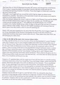
Article, Book, Shire of Diamond Valley, Kangaroo Point, excerpt from Diamond Valley Story, 1979_
References to "Kangaroo Point" taken from The Diamond Valley Story by Dianne H. Edwards, pages 31-32, 97, 109. 4 photocopied pages. kangaroo point -
 Greensborough Historical Society
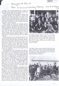
Newspaper Clipping, Diamond Valley Leader et al, Shocking slaughters, 15/08/2018
Several kangaroo joeys were mutilated in a shocking act of animal cruelty in Greenhills, Greensborough.News article 1 page, black text.animal cruelty, greensborough, browns nature reserve greensborough, kangaroos -
 Greensborough Historical Society
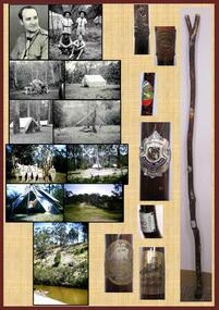
Poster, Lewis C Tulk, My Scout Stave, by Lewis Tulk, 02/02/2018
Lewis Tulk's account of his scouting experiences, including reference to the campsite at Kangaroo Point, Plenty River, Janefield.Laminated poster, with text, black and white and coloured photographs and scout emblem.scouting, lewis tulk -
 Greensborough Historical Society
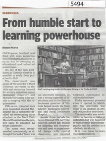
Newspaper Clipping, Diamond Valley Leader, From humble start to learning powerhouse, 24/10/2018
La Trobe University - Once a sparse farmland and filled with more kangaroos than classmates, Bundoora is on its way to become an educational and industrial powerhouse.News article 1 page, black text and colour image .latrobe university, bundoora -
 Greensborough Historical Society
Article, Printer Unknown, Greensborough, 1840o
Details the history of the current Greensborough township. It also mentions the early settlement of Kangaroo Point.Mentions early settlers such as William Poulter, James Chapman, James Mann and Edwin Willis Magger (Maygar).2 page printed document outlining the activities and motives of Edward Bernard Green, an early owner of the area of land that became Greensborough.Pencilled words on front page. greensborough, kangaroo point, edward green, poulter, mann, chapman, magger, mayger, melbourne to sydney mail contract -
 Greensborough Historical Society
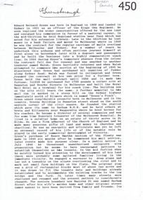
Newspaper Clipping, Culling a mob mentality, 28/10/2015
Diamond Valley Leader Letters to the Editor discuss the issue of kangaroos at Gresswell Forest Reserve.News clipping, black text, colour image.kangaroos, gresswell forest reserve -
 Greensborough Historical Society
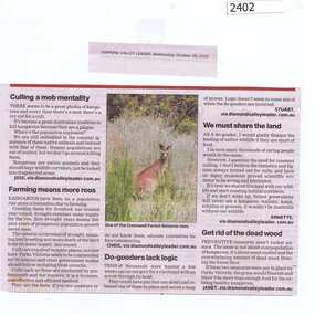
Newspaper Clipping, Call for roo recount, 28/10/2015
Discussion of the proposed cull of kangaroos at Gresswell Forest Reserve.News clipping, black text, colour image.kangaroos, gresswell forest reserve, parks victoria -
 Greensborough Historical Society
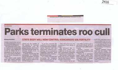
Newspaper Clipping, Parks terminate roo cull, 25/11/2015
Parks Victoria decided not to cull kangaroos at Gresswell Forest Reserve.News clipping, black text.gresswell forest reserve, kangaroos, parks victoria -
 Greensborough Historical Society
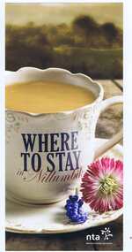
Leaflet, Nillumbik Tourist Association, Where to stay in Nillumbik, 17/10/2015
Lists 10 major tourist accommodations in: Bundoora, Diamond Creek, Eltham, Hurstbridge, Kangaroo Ground, Panton Hill, Research, St AndrewsColour, printed both sides, map of area, A4 folded twicenillumbik -
 Greensborough Historical Society
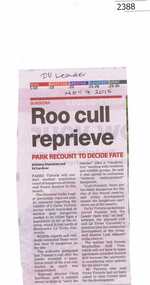
Newspaper Clipping, Roo cull reprieve, 04/11/2015
A recount of kangaroo numbers at Gresswell Forest Reserve Bundoora will decide whether the population should be reduced.News clipping, black text.Date written on clippingbundoora, kangaroos, parks victoria, gresswell forest reserve -
 Greensborough Historical Society
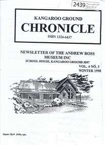
Newsletter, Andrew Ross Museum Inc, Kangaroo Ground Chronicle, 14/07/1998
A single edition (Winter 1998) of the Newsletter of the Andrew Ross Museum in Kangaroo Ground.14 p. Newsletter Vol. 4, No. 3, Winter 1998; with leaflet 2 p. about Andrew Ross Museum andrew ross museum -
 Greensborough Historical Society
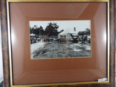
Photograph (Framed), Kangaroo Ground store, 1920s
Photograph shows a group of people and several cars at the Kangaroo Ground store.Framed black and white photograph, in timber frame, under glass with brown mount.kangaroo ground -
 Greensborough Historical Society
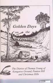
Book, Andrew Ross Museum, Golden days on the Caledonian diggings / Mick Woiwod, 2005_
This book contains the diaries of Thomas Young, 1859-1866 and 1895-1900, based in Kangaroo Ground, Panton Hill and Christmas Hills. Explanatory notes, interpretation etc by Mick Woiwod.69 pages, illus.Signed by author on title page.thomas young, mick woiwod, christmas hills -
 Greensborough Historical Society
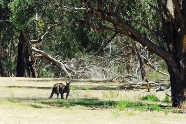
Photograph - Digital image, Marilyn Smith et al, Janefield Precinct: Lone kangaroo, 27/11/2014
Janefield Precinct: Lone kangaroo. The remains of this site are between Greensborough and Janefield. A RAAF Hygiene Training Camp was located on the Plenty River, just south of the Janefield community. It was in use from 1944 to 1946. The Camp was constructed from salvaged materials. Instruction included building and maintenance of grease traps, latrines, elementary plumbing and carpentry.Early remains of a WW2 training camp Digital colour photograph.raaf hygiene training camp janefield -
 Greensborough Historical Society
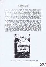
Genealogical document, Margaret Ball, The Bunker family, 1845o
The document outlines the family history of the Bunker and Shillinglaw familes.These families lived in Eltham in the late 19th century.A 10 page photocopied document with a picture of a grave stone on the front page.Some words written in blue biro on the bottom of the second page.eltham, shillinglaw, bunker, dalton street primary school, kangaroo ground, collingwood, research -
 Greensborough Historical Society
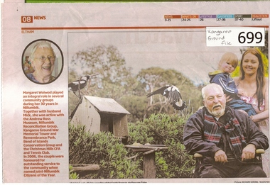
Newspaper clipping, Diamond Valley Leader, A Life Worth Celebrating, 12/09/2012
The item was written about Margaret Woiwod who passed away on August 1 2012.Margaret Woiwod was a prominent community minded person who lived in Bend of Isles for 25 years and later in Eltham North.A multi coloured 1 page newspaper article.Nilbend of isles, kangaroo ground fire tower, nillumbik reconciliation group, woiwod -
 Greensborough Historical Society
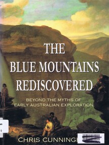
Book, Chris Cunningham, The Blue Mountains rediscovered: beyond the myths of early Australian exploration, by Chris Cunningham, 1996_
Written from both an historical and geographical view, this book tells the story of early inland exploration across the Blue Mountains.Paperback, 192 p., col. photographs, black and white maps.blue mountains nsw -
 Greensborough Historical Society
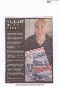
Newspaper Clipping, Diamond Valley Leader, 'Hill-Billies' History Recalled, 25/10/2017
A new book "Do You Recall?" reveals the unusual history of parts of Watsonia where "hill-billies" sat on their porches surveying an area known as Grace Park with only cattle, rabbits and kangaroos for company. The book is available from the Greensborough Historical Society. News article 1 page, black text and colour image.grace park, greensborough historical society, do you recall -
 Greensborough Historical Society
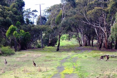
Photograph - Digital image, Marilyn Smith, Blue Lake: Kangaroos at Yellow Gum Park, 19/06/2015
Blue Lake is in Yellow Gum Park in the Plenty Gorge, north of Greensborough. These photos show kangaroos in the Park.Digital copy of colour photographsyellow gum park, blue lake, plenty gorge park -
 Glenelg Shire Council Cultural Collection
Domestic object - Copper Dish, n.d
Round, beaten copper dish with fluted edges. On the front is a small colour badge of Portland lighthouse and headland. The badge sits in the centre of a raised circle, which has impressed images of a koala with baby on it's back, a kookaburra on a branch and a kangaroo in grassland.Back: 'Stokes Melb' - impressed -
Glenelg Shire Council Cultural Collection
Medal - Medal - Australians Town Criers 13th National Championship, n.d
Medal, round brass 'wreath' border/ front and back. Front has enamelled shield, blue background, Australian flag, map of Australia and kangaroo. Inscription on back. Not dated. Attached to green and yellow striped ribbonFront: 'ANCIENT & HONOURABLE GUILD O FAUSTRALIAN TOWN CRIERS 13TH NATIONAL CHAMPIONSHIP. SYD CUFFE GLENELG SHIRE COUNCIL VIC. -
Glenelg Shire Council Cultural Collection
Souvenir - Sticker - Casterton, n.d
Green and white shield shaped vinyl sticker; depictions of kangaroo and emu; green print 'CASTERTON' on top edge; 'HENTY & MITCHELL COUNTRY Victoria' on lower. Mounted on white card.souvenir, casterton -
Glenelg Shire Council Cultural Collection
Souvenir - Badges - VAYC Portland, n.d
2 metal badges, circular, enamel, blue and white with kangaroo motif. VAYC PORTLAND -
 Halls Gap & Grampians Historical Society
Photograph - B/W, 1866
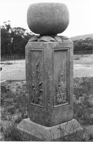
Watkins created his sculpture for an exhibition in Melbourne 1866: "I dressed the pillar about 2 foot 6 inches high and 16 inches square and proceeded to carve in each panel representation characteristic of Victoria 1st Panel a Kangaroo in a small scrub thicket, 2nd an Emu amongst a clump of little flowering correa; 3rd the Wimmera Down and on the 4th side my name and the date AD 1866 On the top of the pillar was an urn of globular form to represent the seed pod of the Eucalypti with spreading leaves underneath" Extract taken from 'Victoria's Wonderland' a Grampians history Monument now in private handsHeatherlie Quarry; Obelisk : Photo shows stone monument created by Francis Watkins using materials from quarry Photo shows two sided view of monument with large stone on topquarrying, mt difficult quarry -
 Halls Gap & Grampians Historical Society
Photograph - B/W, C 1900
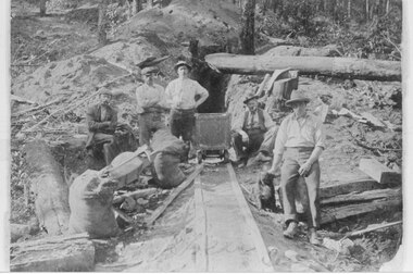
This claim was named "Kangaroo". It had a deep tunnel but produced little gold. The claim was later sold to an Ararat Syndicate which sluiced out the tunnel.Photo of five miners grouped about a trolley at the mouth of a tunnel.mining, mafeking -
 Halls Gap & Grampians Historical Society
Photograph - Photocopy, C December 1925
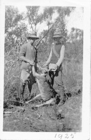
This is a copy of a photo of W. Evans and H. Lewis in the Wannon Valley at Christmas 1925.The photo shows two men wearing hats holding up a dead kangaroo by its ears and forefeet. They are standing in a grassed area surrounded by bush."1925" was written on the bottom edge of the original photo.recreation, hunting, wildlife, fauna -
 Eltham District Historical Society Inc
Photograph, Spring Excursion, Hume and Hovell bus tour Stage 2, Seymour, Benalla; 26 Oct 1997, 26/10/1997
MONUMENT HUNTING THE HUME AND HOVELL WAY (Newsletter No. 117, November 1997, by Diana Bassett-Smith) Sunday October 26 1997 dawned bright and very warm. Some twenty-five members, complete with picnic baskets, met outside the Eltham Library awaiting the Cobb and Co. large coach which would be taking us on the second leg of our travels along the route of the early explorers Hume and Hovell. Stephen West was our very good driver for the day. He would be guided around the circuitous route by Russell Yeoman wh9 had made a detailed study, not only of the intended route, but of the story of these two explorers. During the trip Russell regaled us with poetry, quotations from the Journals and the History of the Shire of Seymour, "The New Crossing Place: by Martindale, 1982, (now Mitchell Shire due to the recent amalgamations). We headed towards the Hume Highway via Greensborough and Cooper Street and proceeded north to our first stop, noting on the way Monument Hill in the distance which is near Kilmore and, according to Russell, well worth the effort to visit as the view across the valley is magnificent. Past Sunday Creek Valley, Mt Piper and Mt Disappointment, all traversed and noted and named by them. We passed through Tallarook, then onto Seymour where we took photos of the monument telling us that Hume and Hovell had passed through on the 28th of October 1824. We also deviated down Hume and Hovell Road viewing deer and emu farming and the Bellbourie property now a sanctuary. Leaving Seymour behind we travelled up the Avenel Road to the Avenel monument, pyramidal in design of four reducing square blocks with a sharply pointed peak, erected in 1924 in memory of the 1824 exploration. The day was warming up and the countryside showing the dryness of the current drought. A parallel note had been made in their journal too of 1824 of the drought appearance of the country they were traversing. At Seven Creeks, Euroa we stopped for some minutes to check the monument placed 20th November 1924 to commemorate their passage on the 29th December 1824. More photos. Russell had pointed out the abrupt termination of the distant ranges which is noted in their journal. The next monument is beside the road at the entrance to Honey Suckle Creek Caravan Park, Violet Town. The squarish shaped monument some eight feet high is topped with a simple steel cross, and was to mark the date of 28th December 1824 and built for the 20th November 1924. By now it was 12.20 and nearly lunchtime as we drove along the Warranbayne Road to Roach's Road, monument hunting without success. Though there is a large, what appears to be an old timber sign which was hard to read, maybe this was the lost monument. In many of the paddocks hay had been cut and baled or was being cut, what a contrast to the rugged country they had passed through which was smoky from the fires of the natives burning off By 1.00 pm we were at Benalla and pulled up beside the park where abundant beds of roses filled the air with their scent and the smell of barbecued food twitched the nostrils whilst the cheerful sounds of other picnickers could be heard throughout the park. We left the bus and collected up our picnics, dispersed to the various tables and enjoyed the shade from the various European trees. 2.00 pm and we were on the road again driving along the Benalla, Mansfield, Yea road. The Swanpool monument states that they passed four miles south and returned three miles north. Then we stopped at the Barjarg monument which notes that they camped near this spot. It is again a pyramidal monument and this time topped with a steel arrow indicating their route of the 29th November 1824. Half an hour later we came to another monument, again with a steel arrow marker on top and the plaque dated the 2nd of 12th 1824. Erected on the 12th of 12th 1924. "They blazed the way that we might inherit the land." Another square based and needle topped monument appeared at Yarck near Yea and this plaque records the date of 3 December 1824. Near McGuigans Road Russell related that the expedition had lost a dog but it had found them next day, the dog was apparently torn by a kangaroo. A short while later Russell reminded us here of the problems they encountered in crossing the Goulburn River near Molesworth where banks were high, water deep and wide. "Good coat of grass but quite dry due to drought". At Yea we stopped for afternoon tea and raided the last of our picnics and looked at the monument to their journey of 1824, situated at a corner of the gardens near the bowling green. No photo – we were out of film. We returned home via Kinglake West and Whittlesea past the Yan Yean Reservoir, not full. 5.00 pm back at Eltham we emptied out of the bus and everyone, including Joan Cole, collected their things, Joan also had the major souvenir of the day, a large carp she had picked up from the river bank, her cat was in for a great feast. The day was made so interesting by the informed commentary which Russell provided. His background knowledge of the route and nature of the journey could only have come from many hours of reading and driving the area. Thank you to Russell and to everyone who made the day so informative and pleasurable. Diana Bassett-Smith. Record of the Society's history of activities - Spring 1997 excursionRoll of 35mm colour negative film, 6 stripsFuji 200shire of eltham historical society, activities, pretty hill, seymour, benalla, hume and hovell, monuments -
 Eltham District Historical Society Inc
Photograph, Spring Excursion, Hume and Hovell bus tour Stage 2, Seymour, Benalla; 26 Oct 1997, 26/10/1997
MONUMENT HUNTING THE HUME AND HOVELL WAY (Newsletter No. 117, November 1997, by Diana Bassett-Smith) Sunday October 26 1997 dawned bright and very warm. Some twenty-five members, complete with picnic baskets, met outside the Eltham Library awaiting the Cobb and Co. large coach which would be taking us on the second leg of our travels along the route of the early explorers Hume and Hovell. Stephen West was our very good driver for the day. He would be guided around the circuitous route by Russell Yeoman wh9 had made a detailed study, not only of the intended route, but of the story of these two explorers. During the trip Russell regaled us with poetry, quotations from the Journals and the History of the Shire of Seymour, "The New Crossing Place: by Martindale, 1982, (now Mitchell Shire due to the recent amalgamations). We headed towards the Hume Highway via Greensborough and Cooper Street and proceeded north to our first stop, noting on the way Monument Hill in the distance which is near Kilmore and, according to Russell, well worth the effort to visit as the view across the valley is magnificent. Past Sunday Creek Valley, Mt Piper and Mt Disappointment, all traversed and noted and named by them. We passed through Tallarook, then onto Seymour where we took photos of the monument telling us that Hume and Hovell had passed through on the 28th of October 1824. We also deviated down Hume and Hovell Road viewing deer and emu farming and the Bellbourie property now a sanctuary. Leaving Seymour behind we travelled up the Avenel Road to the Avenel monument, pyramidal in design of four reducing square blocks with a sharply pointed peak, erected in 1924 in memory of the 1824 exploration. The day was warming up and the countryside showing the dryness of the current drought. A parallel note had been made in their journal too of 1824 of the drought appearance of the country they were traversing. At Seven Creeks, Euroa we stopped for some minutes to check the monument placed 20th November 1924 to commemorate their passage on the 29th December 1824. More photos. Russell had pointed out the abrupt termination of the distant ranges which is noted in their journal. The next monument is beside the road at the entrance to Honey Suckle Creek Caravan Park, Violet Town. The squarish shaped monument some eight feet high is topped with a simple steel cross, and was to mark the date of 28th December 1824 and built for the 20th November 1924. By now it was 12.20 and nearly lunchtime as we drove along the Warranbayne Road to Roach's Road, monument hunting without success. Though there is a large, what appears to be an old timber sign which was hard to read, maybe this was the lost monument. In many of the paddocks hay had been cut and baled or was being cut, what a contrast to the rugged country they had passed through which was smoky from the fires of the natives burning off By 1.00 pm we were at Benalla and pulled up beside the park where abundant beds of roses filled the air with their scent and the smell of barbecued food twitched the nostrils whilst the cheerful sounds of other picnickers could be heard throughout the park. We left the bus and collected up our picnics, dispersed to the various tables and enjoyed the shade from the various European trees. 2.00 pm and we were on the road again driving along the Benalla, Mansfield, Yea road. The Swanpool monument states that they passed four miles south and returned three miles north. Then we stopped at the Barjarg monument which notes that they camped near this spot. It is again a pyramidal monument and this time topped with a steel arrow indicating their route of the 29th November 1824. Half an hour later we came to another monument, again with a steel arrow marker on top and the plaque dated the 2nd of 12th 1824. Erected on the 12th of 12th 1924. "They blazed the way that we might inherit the land." Another square based and needle topped monument appeared at Yarck near Yea and this plaque records the date of 3 December 1824. Near McGuigans Road Russell related that the expedition had lost a dog but it had found them next day, the dog was apparently torn by a kangaroo. A short while later Russell reminded us here of the problems they encountered in crossing the Goulburn River near Molesworth where banks were high, water deep and wide. "Good coat of grass but quite dry due to drought". At Yea we stopped for afternoon tea and raided the last of our picnics and looked at the monument to their journey of 1824, situated at a corner of the gardens near the bowling green. No photo – we were out of film. We returned home via Kinglake West and Whittlesea past the Yan Yean Reservoir, not full. 5.00 pm back at Eltham we emptied out of the bus and everyone, including Joan Cole, collected their things, Joan also had the major souvenir of the day, a large carp she had picked up from the river bank, her cat was in for a great feast. The day was made so interesting by the informed commentary which Russell provided. His background knowledge of the route and nature of the journey could only have come from many hours of reading and driving the area. Thank you to Russell and to everyone who made the day so informative and pleasurable. Diana Bassett-Smith. Record of the Society's history of activities - Spring 1997 excursionRoll of 35mm colour negative film, 6 stripsFuji 200shire of eltham historical society, activities, pretty hill, seymour, benalla, hume and hovell, monuments