Showing 462 items
matching latrobe collection
-
 Bendigo Historical Society Inc.
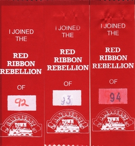
Ephemera - RED RIBBON COLLECTION: THREE RED PARTICIPATION RIBBON
In 1853, Bendigo Miners protested against the 30 shilling miners licence the had to pay the government. They wore red ribbons to show their protest and shopkeepers hung red ribbons outside their premises in support. Thousands of miners signed a petition to Governor LaTrobe to no avail. A protest gathering in Pall Mall marched to the Government camp on Camp Hill but this was a peaceful event again to no real avail.Three participation ribbons for Red Ribbon Agitation re-enactments in 1992, 1993 and 1994. Written on ribbons in white print ' I joined the Red Ribbon Rebellion of (year). On bottom, a scroll with Sandhurst Town written.bendigo, history, red ribbon agitation -
 Bendigo Historical Society Inc.
Photograph - RED RIBBON COLLECTION: DVD
In 1853, Bendigo Miners protested against the 30 shilling miners licence the had to pay the government. They wore red ribbons to show their protest and shopkeepers hung red ribbons outside their premises in support. Thousands of miners signed a petition to Governor LaTrobe to no avail. A protest gathering in Pall Mall marched to the Government camp on Camp Hill but this was a peaceful event again to no real avail.DVD. Red Ribbon Rebellion - three photos. -
 Eltham District Historical Society Inc
Photograph - Digital Photograph, Alan King, Diamond Creek, Barak Bushlands, Eltham, 2008
A habitat corridor and it strengthens the community. Published: Nillumbik Now and Then / Marguerite Marshall 2008; photographs Alan King with Marguerite Marshall.; p185 Barak Bushlands lie west of the Diamond Creek on the corner of Falkiner Street and busy, noisy Main Road. They form part of an important habitat corridor linking the Yarra River to the Kinglake National Park.1 Manna Gums, tawny frogmouths and platypuses are some of the indigenous plants and animals that have made their home there. The bushlands are the result of more than nine years of hard work by the local community with the Nillumbik Council, to transform a degraded flood plain into this refuge of natural beauty. In 1997, shortly after moving into the new Riverside Estate on Falkiner Street, Eltham, several residents noticed the sorry state of the Diamond Creek and surrounding area. Part of it was used as a cow paddock and although small patches of vegetation survived, the area was infested with weeds, rabbits, rubbish and drainage from the housing estate. At various times the 4.4 hectares had been used as a market garden and for shire stock piles. The residents began to restore the area by revegetating land along the Diamond Creek. In 1998 they established the Friends of the Diamond Creek Falkiner Street Reserve2 and 35 families joined from the 90-house Estate. Carolyn Mellor, as the Friends’ Land Manager, undertook a four-year horticulture course to guide this massive project for a volunteer organisation. Since 1999, she has been the Friends’ President. In 1999 the Friends urged the Nillumbik Council to undertake a feasibility study into establishing a wetland system and urban forest. Work began in 2002 with Nillumbik Council funding the project, supplemented by government grants. The Friends also received grants from Melbourne Water and Parks Victoria. Aided by the Friends and other community members, the Council created the Barak Bushlands consisting of a forest, a wetland, a bridge, a path and open space. The beautiful wetland treats most of the estate’s stormwater runoff. Storm water is filtered through plants in the wetland ponds then is released slowly into the billabong, before flowing into the Diamond Creek. The wetland also helps to minimise flooding and the improved water quality provides a flora and fauna habitat. The Friends and other volunteers planted more than 27,000 plants, more than one third of which they grew from seeds they collected at Lower Eltham and Wingrove Parks. Eltham High School students planted thousands of these through a Year Eight program introduced for this purpose. Other groups who assisted were: Green Corps, local Scouts and Guides – 2nd Montmorency, 1st Diamond Creek and 1st Eltham Cub Packs, Eltham College students, Eltham East Primary School, Landcare members, Eltham Lions Club and the Eltham Baptist Church. To maintain enthusiasm for the mammoth task, the Friends and other volunteers ‘adopted’ trees to water and wrote their names on the stakes. In 2004, to recognise the area’s original occupiers, the reserve was named Barak Bushlands. William Barak, who lived from 1824 to 1903, was the last chief of the Yarra Yarra tribe of the Wurundjeri-willam people. Traces of these original inhabitants remain in scar trees (bark sections removed to make a shield or canoe). That same year the Friends’ group was a finalist in the prestigious Federal Government, Banksia Environmental Awards. The Friends have also participated in Clean Up Australia, removing tonnes of rubbish and regularly testing the billabong, wetland and creek, for pollutants. For years the Friends, together with the Australian Platypus Conservancy, have tagged, measured and checked the health of platypuses from the Diamond and Mullum Mullum Creeks. With Latrobe University the Friends have conducted night walks to view owls, possums, bats and sugar gliders. Challenges for the council and the Friends continue with a large rabbit population, some vandalism, weed eradication and maintenance. However, thanks to this community effort, locals can now escape confined urban living on small blocks of land and enjoy the beauty of indigenous plants and animals. Working together has also strengthened the local community,This collection of almost 130 photos about places and people within the Shire of Nillumbik, an urban and rural municipality in Melbourne's north, contributes to an understanding of the history of the Shire. Published in 2008 immediately prior to the Black Saturday bushfires of February 7, 2009, it documents sites that were impacted, and in some cases destroyed by the fires. It includes photographs taken especially for the publication, creating a unique time capsule representing the Shire in the early 21st century. It remains the most recent comprehenesive publication devoted to the Shire's history connecting local residents to the past. nillumbik now and then (marshall-king) collection, barak bushlands, diamond creek (creek), eltham -
 Federation University Art Collection
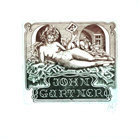
Work on paper - Artwork - Bookplate, 'Ex Libris Bookplate John Gartner'
John Gartner was a fine printer and publisher, an author, a noted philatelist, and also collector of Australian banknotes and coins. He was born on 16 July 1914 and was largely self-educated, leaving school at fourteen for work following the death of his father. Gartner developed a strong interest in the history of typography and printing and was apprenticed at the Advocate where his father had been a linotype operator. Aged 17, Gartner bought a hand press and some fonts of type, and in 1937 acquired a platen press from which he set and printed his private press books, published under the imprint of The Hawthorn Press. Gartner had a strong collection of Australian bookplates. He also looked at the work of artists overseas and commissioned personal plates. He subsequently built an international collection with preference for artists who printed from wood. His initial searches were in Belgium and Holland.(http://www3.slv.vic.gov.au/latrobejournal/issue/latrobe-84/t1-g-t7.html)Etching showing a reclining nude woman holding the letter E in the foreground and a printmaker in the background. Signature bottom right hand cornerkeith wingrove memorial trust, bookplate, australian bookplate design awards, printmaking, nude -
 Whitehorse Historical Society Inc.
Map - Civic Map, Subdivision of Village of Springfield, 1861
... Collection of Maps, LaTrobe Library"... Collection of Maps, LaTrobe Library" Map of the subdivision ...Map of the subdivision of the Springfield Estate, Nunawading, 1861. The Springfield Estate was located in the Northwest corner of Whitehorse Road and Springvale Road.Map of the subdivision of the Springfield Estate, Nunawading, 1861. Springfield Estate was located in the Northwest corner of Whitehorse Road and Springvale Road.non-fictionMap of the subdivision of the Springfield Estate, Nunawading, 1861. The Springfield Estate was located in the Northwest corner of Whitehorse Road and Springvale Road.springfield estate, whitehorse road nunawading, springvale road nunawading -
 Bendigo Historical Society Inc.
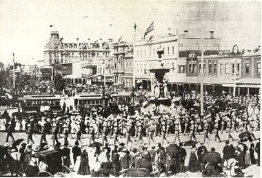
Photograph - BASIL MILLER COLLECTION: MILITARY PARADE WITH TRAM
Reproduction of photograph, shows tram in background of Alexandra Fountain, military personnel in foreground could be Bendigo Volunteer Rifles(?) on back, handwritten, 'From Bendigonian by courtesy of the Latrobe Library.'basil miller, bendigo trams -
Clunes Museum
Book, John Woodland, R.H. Bland and the Port Phillip and Colonial Gold Mining Company, 2002
A Thesis by John George Woodland, Latrobe University, Victoria, Australia January 2002 FOR A "MASTER OF ARTS" DEGREEHARDCOVER BOOK RED COVER WITH GOLD EMBOSSING ON THE FRONT COVER AND SPINE 179 PAGESnon-fictionA Thesis by John George Woodland, Latrobe University, Victoria, Australia January 2002 FOR A "MASTER OF ARTS" DEGREEthesis, r h bland, port phillip and collonial gold mining company -
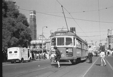 Melbourne Tram Museum
Photograph - Digital Image, changing the points for the cross over in Latrobe St, late 1960's or 1970
Digital image of a photograph from the Ron Scholten Collection of a conductress / conductor changing the points for the cross over in Latrobe St on the east side of Swanston St. The tram has terminated, for a Parade, possibly Moomba during the late 1960's or 1970 as the tram not fitted with side marker lights. In the background is the shot tower with a Penfolds Advert, the Argus building and the ? book Depot. A St Johns ambulance first aid van is parked. The tram has an advert for Queens Bridge Motor Holden and Viva cars (Vauxhall originally) and has a destination of Thornbury - Miller St Tram either SW6 855 or 955.trams, tramways, w6 class, latrobe st, crossover, events, swanston st, thornbury, conductors, conductresses, tram 855, tram 955 -
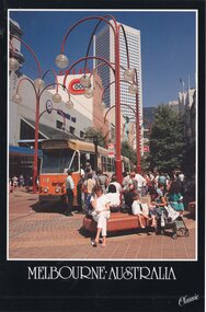 Melbourne Tram Museum
Postcard, Nu-color-Vue, Z110 in the Bourke St Mall, late 1980's
Colour postcard divided back, black border, - Nu-Color-Vue, The Classic Collection of Z110 in the Bourke St Mall, at the Swanston St tram stop, late 1980s. Has the Coles store in the background. Tram has the destination of Route 87, LaTrobe University. Back has space for name and address, stamp and a message and details of the postcard. Produced by Nu-Color-Vue, number 140 117, NCV 6340. Has "Melbourne Australia" along the bottom edge.trams, tramways, bourke st, route 87, mall, z class, tram 110 -
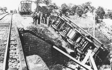 Ringwood and District Historical Society
Photograph, Train derailment at Wantirna Road subway in Ringwood, looking towards station. Station St. on right. 1/2/1902
Black and white photographs - 2 copiesVarious accompanying inscription beneath and on back of photographs. They read as follows: "Train derailment at Wantirna Road subway looking towards station. Station St. on right. 1/2/1902. This date has been written as 1908 on other locations in other places. Area behind engine was later railway car park." "Ringwood derailment 1902 (copied from magazine Latrobe library [ARHS Vic. Div. photo collection #748-1]. Cross at lower right marks spot from where fireman McKeone was rescued. Wantirna Rd. underpass. Station to left". -
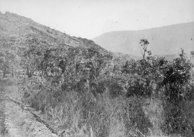 Stawell Historical Society Inc
Photograph, Grampians Entrance to Halls Gap 1866
Grampians Entrance to Halls Gap. Part of a collection of Photographs by Mr. O.G. Armstrong as commissioned by the Shire of Stawell for the Inter-colonial and Paris Exhibition in Melbourne in 1866. Halls Gap is named after Charles Browning Hall. In his letter to Joseph Latrobe he gives no clue about his early life except that he was a stock herder as early as 1837. He held two runs in the Wimmer district, that of La Rose and Mokebila in the Grampians (1841 to 1842). He then moved to the Clunes area in 1851. He was a member of the Carisbrook Magistrates Bench. stawell -
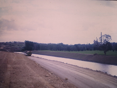 Kew Historical Society Inc
Photograph - Construction of the Eastern Freeway (F19), Ron Setford, November 1972
Ron Setford and his wife Grace Setford lived in Tanner Avenue, East Kew, from c.1946 to c.1995. A keen photographer, he recorded the changing face of Kew over a 20 year period. Apart from 30 photographs of built structures and places in Kew dating from 1960 and 1961, 145 of his 35mm colour slides chronicle the development of the F19 (later renamed Eastern) Freeway through the Yarra Valley in Kew over a five year period from c.1972 to c.1977. This important collection was donated to the Society by his granddaughter in 2025.This collection of 175 35mm slides is of local and statewide significance, owing to its subject matter, particularly the major development of road transport infrastructure during the 1970s with the construction of the Eastern Freeway. The photographer also took care to annotate and date most of his slides which enable the researcher to pinpoint temporal and spatial locations."New river course / Latrobe golf club across river / Nov 72"ron setford, eastern freeway, f19 freeway