Showing 11589 items matching " map"
-
 Federation University Historical Collection
Map - Framed image, Public Record Office Victoria, Eureka Treason Trial Map (printed copy), 1855
The persecution produced the original of this map as an exhibit for the Treason Trials of thirteen of the Eureka Stockade in Melbourne in 1855. Witnesses at the time accepted that the map showed the location of the stockade at Ballarat and the route taken by the military and police when the stockade was attacked on 03 December 1854. The original of this work is held by the Public Record Office Victoria.Printed copy of the plan used at the Eureka Treason Trials in 1855.eureka stockade, treason trial map, ballarat, lydiard street north, camp street, paroompi, yarrowee creek -
 Peterborough History Group
Map - Map of Peterborough House 1921, 1921
This hand drawn map of the buildings and out buildings was done for insurance purposes. It indicates which buildings are covered and which are uninsured. Significant as it shows a plan of the hotel as it was in 1921. Each building is labelled by its purpose, which provides an interesting insight into holidays of the time. For example, 'sleep outs' and external bathrooms. A4 photocopy of a hand drawn map of the buildings and out buildings comprising Peterborough House. Hand drawn map -
 Bendigo Military Museum
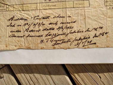
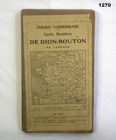
Accessory - MAP, 1914-1919
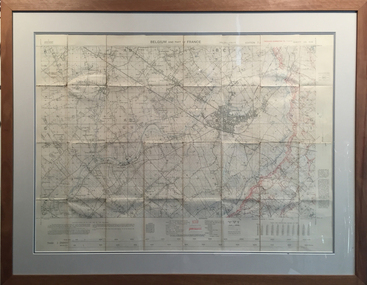
The map belonged to Jack Grinton No 1043, 38th Batt AIF. Part of the Grinton collection which included hundreds of negatives and developed photos that he took during the War. Refer Cat No 1280 for service details. Refer 1317P, 1320P.Map of a small sector of France. The coloured map is on a grey canvas backing. Map covers an area from the coast to Amiens to St Quentin-north to south from Bethune-Arras-Richecourt. The map has 32 panels and folds down into one."Carte Routiere De Dion Bouton Amiens"docuents-maps-france, military history -
 Federation University Historical Collection
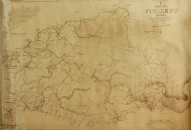
Map, Plan showing Locality of Reported Gold Find District of Tavula, 1935
Map with coloured shading on paper backed onto linen showing Crown Indian Settlement, Tovatova, Koro, Devotamap, devota, koro, crown indian settlemt, tovatova, tavua -
 The 5th/6th Battalion Royal Victoria Regiment Historical Collection
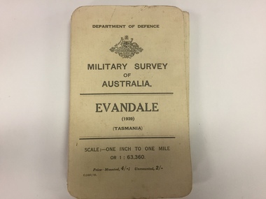
Map, Military Survey of Australia. Evandale (1939) (Tasmania), 1939
Fabric backed colour map, with card cover that folds into a small book. Scale one inch= one mile.military, survey, map, tasmania, ww2, wark vc club -
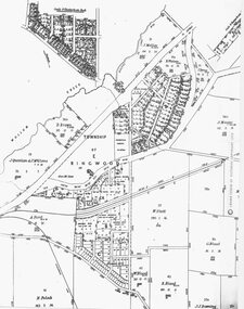 Ringwood and District Historical Society
Photograph, Parish Map - Township of Ringwood - 1890
Written on backing sheet, 'SLV Parish Map Collection. Vol.67, Fol. 43, 1890'. Catalogue card reads, 'SLV Parish Map Collection 1890. (Township of Ringwood). -
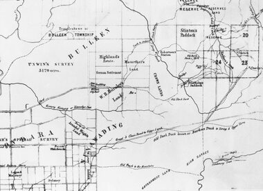 Ringwood and District Historical Society
Photograph, Circa 1855 Parish Map including Bulleen, Nunawading, and eventual site of Ringwood below blocks 23 & 24
Catalogue card reads, "C1858 Parish Map - Nunawading, Ringwood & Scoresby". -
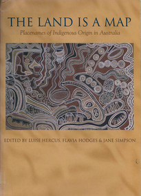 Victorian Aboriginal Corporation for Languages
Book, Luise Hercus, The land is a map : placenames of Indigenous origin in Australia, 2002
Place names often evoke important information about features of the environment and their place in Indigenous knowledge. On the other hand, place names given by European settlers are largely arbitrary.Maps, b&w photographs, b&w illustrations, word listsplace names, wik, cape york peninsula, ngalakgan, alawa, marra, yukgul, kaurna, yuwaalaraay, yuwaaliyaay, gamilaraay, ngiyampaa -
4th/19th Prince of Wales's Light Horse Regiment Unit History Room
Booklet, Manual of Map Reading, Air Photo Reading & Field Sketching Part 1 Map Reading 1955, 1955
Hard covered booklet for use of officer, NCOs and candidates for commission in the British Army and RAF explaining how to use a map and how to extract information from it. 4 copiesWO Code No 8868map reading -
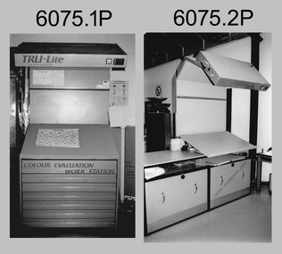 Bendigo Military Museum
Photograph - Equipment used in Map Production at the Army Survey Regiment, 1991
These nine photographs of technical equipment were provided to the Directorate of Survey as input to the 1990-1991 Annual Report. The equipment in Photos .1P and .2P were used to evaluate/validate colour values on printed maps. The equipment in Photo .3P is a daylight film processor. The Optronix 5040 Laser Scanner/Plotter was shown in Photos .4P to .6P. The Print Room’s Map Handling Station in photo .7P provided ergonomic benefits to the Printer Technician and improved despatching productivity. The Optical Disk Archive and Retrieval System (ODARS) equipment in .8P was optical "platter" disk technology for the secure and long term archive storage of large amounts of digital map data. Map data was transferred from large reels of magnetic tape. As most map type (letters and names) generation was done in Automap 2, The ITEK Typesetter shown in photo .9P was close to obsolete in 1991. At this time it was used to generate map type for other RASvy units, contractors and sections still performing manual map production at Army Svy Regt.This is a set of photographs of Army Survey Regiment technical equipment taken in 1991. The photographs were printed on photographic paper and are part of the Army Survey Regiment’s Collection. The photographs were scanned at 300 dpi. .1) - Photo, black & white, 1991, Colour Evaluation Workstation No 1, Lithographic Squadron .2) - Photo, black & white, 1991, Colour Evaluation Workstation No 2, Lithographic Squadron .3) - Photo, black & white, 1991, Daylight film processor, Lithographic Squadron, Daylight Working Contacting Frames in background. .4) - Photo, black & white, 1991, Optronix 5040 Laser Scanner/Plotter, Lithographic Squadron .5) - Photo, black & white, 1991, Optronix 5040 Laser Scanner/Plotter, Lithographic Squadron .6) - Photo, black & white, 1991, Optronix 5040 Laser Scanner/Plotter, Lithographic Squadron .7) - Photo, black & white, 1991, Map Handling Station, Lithographic Squadron .8) - Photo, black & white, 1991, Optical Disk Archive and Retrieval System (ODARS), Cartographic Squadron .10) - Photo, black & white, 1991, Optronix 5040 Laser Scanner/Plotter, Lithographic Squadron .9) - Photo, black & white, 1991, ITEK Typesetter, Cartographic Squadron.1P, .2P, .4P to .10P – equipment description annotated on back .3P - no annotation.royal australian survey corps, rasvy, army survey regiment, army svy regt, fortuna, asr, litho, automap -
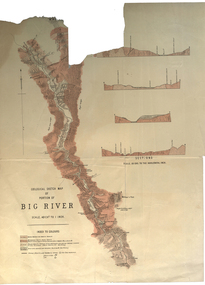 Federation University Historical Collection
Plan, Geological Sketch Map of Portion of Big River
Printed map on paperscale, index to colours, sectionsgeological sketch map, plan, big river, mount wills, geology -
Federation University Historical Collection
Map - Map - Geological, Kejimkujik Lake, Nova Scotia: Geological Map 94-05, 1994
Produced by Nova Scotia Department of Natural Resources, Mines and Energy Branches. The Minister of the Department was the Honourable Donald R Downe and the Deputy Minister was Darrell D HiltzLarge coloured map depicting different areas and deposits. Includes a legend, symbols used, mineral abbreviations and alteration abbreviations.Symbolskejimkujik lake, nova scotia -
 Flagstaff Hill Maritime Museum and Village
Document - Map, Department of Lands & Survey, Victoria / Panmure, 1942
This Emergency Edition of the map of Panmure, Victoria, is part of the W.R. Angus Collection. It was printed in 1942 during World War II. It is one of two maps donated to Flagstaff Hill Maritime Village by the family of Doctor William Roy Angus, who served as Surgeon Captain in the Australian Defence Department. The map was compiled for the Dept. of Army by the Dept. of Lands and Survey in Melbourne, prepared by the Australian Section of the Imperial General Staff, which was a British Government body created in 1907 to co-ordinate the defence of Britain and its Empire. It was printed by A.H.Q. Cartographic Company, Survey Corps, which was formed in 1941. The Corp changed its name to L.H.Q. Cartographic Company of Bendigo. In 1947 the name reverted back to the A.H.Q. Cartographic Company until 1955 when it became the A.H.Q. Survey Regiment. The W.R. Angus Collection includes historical medical equipment, surgical instruments and material once belonging to Dr Edward Ryan and Dr Thomas Francis Ryan, (both of Nhill, Victoria) as well as Dr Angus’ own belongings. The Collection’s history spans the medical practices of the two Doctors Ryan, from 1885-1926 plus that of Dr Angus who began practice in 1924. Dr. Angus served with the Australian Department of Defence as a Surgeon Captain during the Second World Was from 1942 to 1945. He served in Ballarat, Victoria, and in Bonegilla, N.S.W. until he suffering from a heart attack just before the war ended. ABOUT THE “W.R.ANGUS COLLECTION” - Doctor William Roy Angus M.B., B.S., Adel., 1923, F.R.C.S. Edin.,1928, was generally known as Dr Roy Angus. His working life included a position as a doctor with the Flying Doctor Service in Australia’s rural and remote areas. After many varied experiences Dr Angus and his family moved to Warrnambool in 1939 where he purchased “Birchwood,” the 1852 home and medical practice of Dr John Hunter Henderson. He was appointed on a part-time basis as Port Medical Officer in Warrnambool and held this position until the 1940’s when the government no longer required the service of a Port Medical Officer. Dr Angus was a surgeon at the Warrnambool Base Hospital 1939-1942. After further studies he commenced practice as an ophthalmologist in Warrnambool, pioneering in artificial eye improvements. He was Honorary Consultant Ophthalmologist to Warrnambool Base Hospital for 31 years and made monthly visits to Portland to perform eye surgery. Dr Angus and his wife Gladys were very involved in Warrnambool’s community with a strong interest in civic affairs. They were both involved in the creation of Flagstaff Hill Maritime Village, including the layout of the gardens. After his death on 28th March 1970 his family requested his practitioner’s plate, medical instruments and some personal belongings be displayed in the Port Medical Office surgery at Flagstaff Hill Maritime Village, and be called the “W. R. Angus Collection”. This Emergency Edition of the Map of Panmure is significant as an example of the documents prepared for the defence of Australia in World War 2. The Map is also significant for its connection between the Australian Army and the involvement of Dr WR Angus as a Surgeon in the Medical Services during World War II. The W.R. Angus Collection is significant for still being located at the site it is connected with, Doctor Angus being the last Port Medical Officer in Warrnambool. The collection of medical instruments and other equipment is culturally significant, being an historical example of medicine, administration, household equipment and clothing from late 19th to mid-20th century. Dr Angus assisted Dr Tom Ryan, a pioneer in the use of X-rays and in ocular surgery. The collection includes Dr Angus’s Army objects and is significant as an example of items issued to Doctors and Surgeons in the Medical Services of the Australian Army in World War IIMilitary map of Panmure, Victoria, Australia; part of the W.R. Angus Collection. Rectangular coloured map on cream paper for the Australian Army. Details include sea, waterways and land, contour lines, grid lines, names of districts, towns and roads, bridges, swamps, rail lines, cuttings, tracks, buildings (including blacksmiths), pumps, lighthouses, telegraph, telephones and electric transmission lines, and fire stations. The map has margin notes that include distances in miles to nearby towns. The map was compiled for the Dept. of Army by the Dept. of Lands and Survey in Melbourne, prepared by the Australian Section, Imperial General Staff and printed by A.H.Q. Cartographic Company, Melbourne in 1942. Crown Copyright Reserved. Inscriptions in red print state that it is and Emergency Edition and an Official document. An oval purple stamp includes the price.Printed in black; 'Victoria / Panmure", "No. 930 / Zone 6" Printed in red; “EMERGENCY EDITION”, “THIS MAP IS AN OFFICIAL DOCUMENT. IF FOUND, IT MUST BE HANDED / IN TO THE NEAREST MILITARY HEADQUARTERS OR POLICE STATION” Stamped: within concentric ovals (“- - - FOR SALE / PRICE 2/- / - - - - - OF THE ARMY”)flagstaff hill, warrnambool, flagstaff hill maritime museum, maritime museum, shipwreck coast, flagstaff hill maritime village, great ocean road, dr w r angus, dr ryan, warrnambool base hospital, flying doctor, surgeon captain, australian department of defence, royal australian army, world war 2, map panmure 1942, roy angus, port medical officer, nhill base hospital, military map, emergency map, military service australian army, department of army, department of lands and survey, a.h.q. cartographic company melbourne, panmure 1942, australian section, imperial general staff -
Beechworth Honey Archive
Map- Everton
Map compiled from 1975 aerial photography. Printed in 1979.Map shows Everton, Ovens River, Beechworth- Wangaratta Rd, former Wangaratta- Bright railway. Scale 1:25,000. Printed colour on paper.Map labelled Everton. No. 8225-3-3.map, everton, ovens river, bright, railway, aerial, photography, paper, beechworth honey -
 Federation University Historical Collection
Map, Sebastopol (Delacombe, Redan and Ballarat South) Retail and Business Guide, 2005, 10/2005
Sebasgtopol is a suburb of Ballarat.Sebastopol, Delacombe, Redan and Ballarat South and business guide map.map, guide, delacombe, redan, ballarat south, victorian park, bray raceway, sebastopol equestrian centre, western oval, city oval -
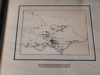 Vision Australia
Map - Object, Victorian railways map
A black and white map of Victoria showing the railway lines where mail is transported and the individual towns listed next to the dot that provides location of such. Underneath is written "Map of Victoria showing the localities beyond the suburbs of Melbourne to which library books are sent to blind members. Books are carried over the railways FREE there is no charge to the readers." Through the work of Tilly Aston, braille postage was provided free by the Victorian Railways which greatly assisted the Braille Library in reaching members who resided outside of Melbourne. This map was produced to show the extent of the work by the Victorian Association of Braille Writers and the need for reading materials across the state.Paper of Victorian railway lines mounted in framevictorian association of braille writers, marketing -
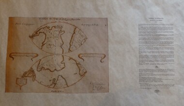 Greensborough Historical Society
Map, Mapping Authority of NSW, Terra Australis: Quinta Pars Orbis, 1676_
The original of this map was drawn by an Italian priest Father Victorio Riccio in 1676 from knowledge brought to Manila on Dutch ships. Father Riccio was suggesting a Catholic mission to Terra Australia.Reproduction of an early map of Australia, pre-dating the voyages of Captain Cook.Facsimile map in cardboard protective tubeterra australis -
Whitehorse Historical Society Inc.
Map, Ringwood, 1935
Australia Ringwood and area map.Australia1:63,360 series map, Ringwood N.849 Zone 7. Scale 1 inch to 1 mile. Approximate scope: Prahran-Cockatoo, Lilydale-DandenongAustralia Ringwood and area map.maps, ringwood -
 Flagstaff Hill Maritime Museum and Village
Document - Map, Department of Lands & Survey, Victoria / Port Campbell, 1942
This Emergency Edition of the map of Port Campbell, Victoria, is part of the W.R. Angus Collection. It was printed in 1942 during World War II. It is one of two maps donated to Flagstaff Hill Maritime Village by the family of Doctor William Roy Angus, who served as Surgeon Captain in the Australian Defence Department. The map was compiled for the Dept. of Army by the Dept. of Lands and Survey in Melbourne, prepared by the Australian Section of the Imperial General Staff, which was a British Government body created in 1907 to co-ordinate the defence of Britain and its Empire. It was printed by A.H.Q. Cartographic Company, Survey Corps, which was formed in 1941. The Corp changed its name to L.H.Q. Cartographic Company of Bendigo. In 1947 the name reverted back to the A.H.Q. Cartographic Company until 1955 when it became the A.H.Q. Survey Regiment. The W.R. Angus Collection includes historical medical equipment, surgical instruments and material once belonging to Dr Edward Ryan and Dr Thomas Francis Ryan, (both of Nhill, Victoria) as well as Dr Angus’ own belongings. The Collection’s history spans the medical practices of the two Doctors Ryan, from 1885-1926 plus that of Dr Angus who began practice in 1924. Dr Angus served with the Australian Department of Defence as a Surgeon Captain during the Second World Was from 1942 to 1945. He served in Ballarat, Victoria, and in Bonegilla, N.S.W. until he suffering from a heart attack just before the war ended. ABOUT THE “W.R.ANGUS COLLECTION” - Doctor William Roy Angus M.B., B.S., Adel., 1923, F.R.C.S. Edin.,1928, was generally known as Dr Roy Angus. His working life included a position as a doctor with the Flying Doctor Service in Australia’s rural and remote areas. After many varied experiences Dr Angus and his family moved to Warrnambool in 1939 where he purchased “Birchwood,” the 1852 home and medical practice of Dr John Hunter Henderson. He was appointed on a part-time basis as Port Medical Officer in Warrnambool and held this position until the 1940’s when the government no longer required the service of a Port Medical Officer. Dr Angus was a surgeon at the Warrnambool Base Hospital 1939-1942. After further studies he commenced practice as an ophthalmologist in Warrnambool, pioneering in artificial eye improvements. He was Honorary Consultant Ophthalmologist to Warrnambool Base Hospital for 31 years and made monthly visits to Portland to perform eye surgery. Dr Angus and his wife Gladys were very involved in Warrnambool’s community with a strong interest in civic affairs. They were both involved in the creation of Flagstaff Hill Maritime Village, including the layout of the gardens. After his death on 28th March 1970 his family requested his practitioner’s plate, medical instruments and some personal belongings be displayed in the Port Medical Office surgery at Flagstaff Hill Maritime Village, and be called the “W. R. Angus Collection”. This Emergency Edition of the Map of Port Campbell is significant as an example of the documents prepared for the defence of Australia in World War 2. The Map is also significant for its connection between the Australian Army and the involvement of Dr WR Angus as a Surgeon in the Medical Services during World War II. The W.R. Angus Collection is significant for still being located at the site it is connected with, Doctor Angus being the last Port Medical Officer in Warrnambool. The collection of medical instruments and other equipment is culturally significant, being an historical example of medicine, administration, household equipment and clothing from late 19th to mid-20th century. Dr Angus assisted Dr Tom Ryan, a pioneer in the use of X-rays and in ocular surgery. The collection includes Dr Angus’s Army objects and is significant as an example of items issued to Doctors and Surgeons in the Medical Services of the Australian Army in World War IIMilitary map of Port Campbell, Victoria, Australia; part of the W.R. Angus Collection. Rectangular coloured map on cream paper for the Australian Army. Details include sea, waterways and land, contour lines, grid lines, names of districts, towns and roads, bridges, swamps, rail lines, cuttings, tracks, buildings (including blacksmiths), pumps, lighthouses, telegraph, telephones and electric transmission lines, and fire stations. The map has margin notes that include distances in miles to nearby towns. The map was compiled for the Dept. of Army by the Dept. of Lands and Survey in Melbourne, prepared by the Australian Section, Imperial General Staff and printed by A.H.Q. Cartographic Company, Melbourne in 1942. Crown Copyright Reserved. Inscriptions in red print state that it is and Emergency Edition and an Official document. An oval purple stamp includes the price.Printed in black; 'Victoria / Port Campbell", "No. 932 / Zone 6" Printed in red; “EMERGENCY EDITION”, “THIS MAP IS AN OFFICIAL DOCUMENT. IF FOUND, IT MUST BE HANDED / IN TO THE NEAREST MILITARY HEADQUARTERS OR POLICE STATION” Stamped: within concentric ovals (“- - - FOR SALE / PRICE 2/- / - - - - - OF THE ARMY”)flagstaff hill, warrnambool, flagstaff hill maritime museum, maritime museum, shipwreck coast, flagstaff hill maritime village, great ocean road, dr w r angus, dr ryan, warrnambool base hospital, nhill base hospital, flying doctor, surgeon captain, map port campbell 1942, roy angus, port medical officer, military map, emergency map, australian department of defence, royal australian army, military service australian army, department of army, department of lands and survey, world war 2, a.h.q. cartographic company melbourne, australian section, imperial general staff, port campbell 1942 -
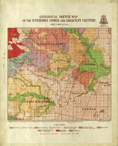 Federation University Historical Collection
Map, Geological Sketch Map of the Werribee Gorge and Adjacent Country, 1914, 1914
A coloured geological sketch map of the Werribee Gorge, Bacchus Marsh, Rowlesy, Darley, Parwan. The scale is 1 mile to 1 inchwerribee gorge, bacchus marsh, darley, parwan, w.e. bennett, bennett, r.a.f. murray, c.c. brittlebank, rowsley -
 Ringwood and District Historical Society
Photograph, Map showing Victoria's proposed railway system, 1890
Catalogue card reads, 'Map showing Victoria's proposed railway system, 1890. -
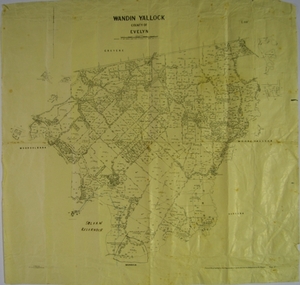 Yarra Ranges Regional Museum
Map, H J Green, Acting Govt. Printer, Wandin Yallock, County of Evelyn (Parish Plan), c. 1910 - 1920
Parish Plan of Wandin Yallock. Location of Silvan Reservoir marked in ink on map.Parish Plan of Wandin Yallock. Location of Silvan Reservoir marked in ink on map. wandin yallock, maps -
Whitehorse Historical Society Inc.
Map, Environment effects statement, 1/03/1979 12:00:00 AM
Diamond Creek-Ringwood study: Planning Scheme reservations and zones with recommended concept.Diamond Creek-Ringwood study: Planning Scheme reservations and zones with recommended concept. City of Nunawading: section north of Canterbury Road. Scale 1:25,000 metric. Map B with drafting ref. no. 145Diamond Creek-Ringwood study: Planning Scheme reservations and zones with recommended concept. city of nunawading, land use, melbourne metropolitan planning scheme -
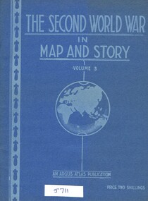 Greensborough Historical Society
Book, Neville Smith, The Second World War in Map and Story, volume 3, ed. by Neville Smith, 1943_
Series of articles published by the "Argus" 1941-1943, dealing with events and campaigns in World War 2.48 p., col. maps.world war 2 -
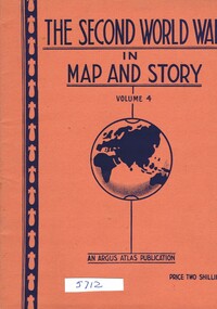 Greensborough Historical Society
Book, Neville Smith, The Second World War in Map and Story, volume 4, ed. by Neville Smith, 1944_07
Series of articles published by the "Argus" 1941-1945, dealing with events and campaigns in World War 2.48 p., col. maps.world war 2 -
 Ballarat Heritage Services
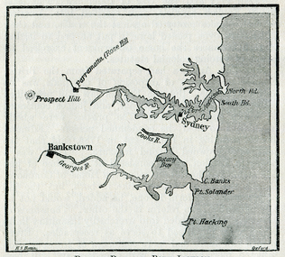
Map, Botany Bay and Port Jackson
Copy of a map from 'A Short HIstory of Australia' by Ernest Scott.map, explorers, exploration, voyages, new south wales coast, port jackson, botany bay bankstown, prospect hill, parramatta, rose hill, sydney -
Whitehorse Historical Society Inc.
Map, Map, Parish of Nunawading, 1850's
A basic map of the Parish of Nunawading to which additions have been made. Scale 70 chains:3.5 inchesA basic map of the Parish of Nunawading to which additions have been made. Scale 70 chains:3.5 inchesmaps, parish of nunawading -
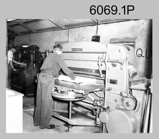 Bendigo Military Museum
Photograph - Printer Technicians trimming printed map stock at the Army Survey Regiment, c1960s to c1980s
These six photographs of Printer Technicians using a heavy-duty guillotine to trim bulk printed map stock were probably taken circa 1960s to 1980s in Lithographic Squadron at the Army Survey Regiment, Fortuna, Bendigo. Personnel are not identified on Photos .3P and .4P, however names are annotated on photos .1P, .2P, .4P and .5P. Cartographers normally provided trim marks to specified map dimensions as guidance to the printer. The trimming stage, like all the other printing processes required high levels of accuracy. These guillotines were extremely powerful to cut through bulk quantities of printed maps, as evident in photos .1P .3P, .4P and .6P.This is a set of photographs of Printer Technicians using a heavy-duty guillotine to trim bulk printed map stock c1960s to 1980s. The photographs were printed on photographic paper and are part of the Army Survey Regiment’s Collection. The photographs were scanned at 300 dpi. .1) - Photo, black & white, c1960s, L to R: ‘Wanger’ Payne, unidentified, Lithographic Squadron .2) - Photo, black & white, c1980s, CPL Ken Cavanagh, Lithographic Squadron .3) - Photo, black & white, c1970s, unidentified, Lithographic Squadron .4) - Photo, colour, c1970s, Peter Saunders, Lithographic Squadron .5) - Photo, black & white, c1980s, L to R: unidentified, WO1 Noel ‘Nesty’ Coulthard, Lithographic Squadron .6) - Photo, black & white, c1980s, unidentified, Lithographic Squadron.1P, .2P, .4P and .5P. personnel annotation on back. * unidentified on .1P due to poor writing. .3P and .6P – no annotationroyal australian survey corps, rasvy, army survey regiment, army svy regt, fortuna, asr, litho, printing -
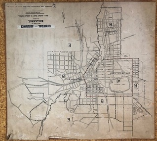 Ballarat Tramway Museum
Map, General Accident Fire and Life Assurance, "Sketch Map of Ballaarat including Ballaarat East and Sebastopol", c1940
Yields information about Ballarat c1940 and how the area was rate for insurance purposes.Map - paper mounted onto a heavy card backing titled "Sketch Map of Ballaarat including Ballaarat East and Sebastopol" with a printed label "General Accident Fire and Life Assurance" pasted to the top of the title. Drawn at 30chains to the inch. Map shows the boundaries between the carious insurance classifications in the district, which relates partly to the local government areas at the time. Shows the Yarrowee, Gong Gong Creeks, rail lines, stations, Black Hill and some other features. Includes the Explosives factory area. Does not show the tram lines.trams, tramways, ballarat, maps, insurance, sebastopol -
 Tramways/East Melbourne RSL Sub Branch - RSL Victoria Listing id: 27511
Map and Legend, Trench Map - France Sheet 36 N.W
This is an actual battle map used by Australian Forces in the battle of the Somme in France in April 1917. It is an ordinance survey map of the trenches in the area. It is framed in two pieces, one being the main map and the other the legend used to read the map. It details the river 'La Lys Riviera' and the city 'Armentieres', in the Somme. somme, trench map, ww1, belgium, france, armentieres, 1917, ordinance survey map