Showing 11120 items
matching planning
-
 Whitehorse Historical Society Inc.
Article, Bridge Plan under fire, 2016
Whitehorse Council has demanded a meeting with Planning Minister Richard Wynne.Whitehorse Council has demanded a meeting with Planning Minister Richard Wynne after he controversially approved Deakin University's plan for a bridge in a Burwood Park.Whitehorse Council has demanded a meeting with Planning Minister Richard Wynne. city of whitehorse, deakin university burwood campus, burke, anna, wynne, richard -
 Greensborough Historical Society
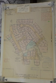
Planning Document, Subdivision Plan # 1016. Corner Weidlich and St Clems Roads Greensborough, 05/10/1981
Plan of Subdivision of land at corner of Weidlich Road and St Clems Road Greensborough.Plan (2 sheets) mounted on heavy card.Stamped and handwritten Council permissions, dates and other details.subdivision plans, weidlich road -
 Mission to Seafarers Victoria
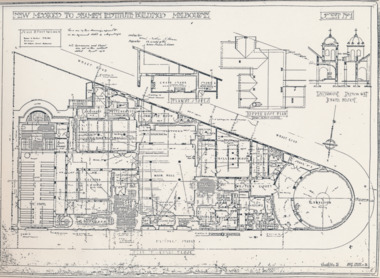
Plan - Architectural drawings, Walter Butler, New Missions to Seamen Institute Buildings Melbourne, 1916
In August 1916, Walter R. Butler presented the plans for the future central Seamen's Institute.The drawings show the original plans with rooms' names and intended use. They also show the original concept for the chapel which was in the Spanish Mission style.Plan copied from the 1983 Howden and Wardrop A4 report. A large plan on tracing paper (original or copy of the original) is held in the MSTV archives.flinders street, mission to seamen, mission to seafarers, walter richmond butler (1864–1949), norla dome, st peter chapel, spanish mission, arts and crafts, 1916 -
 Kew Historical Society Inc
Plan - Subdivision Plan, Argyle Road, Heather Grove, Victor Avenue, Kew, c.1937
The Kew Historical Society's map collection includes a substantial number of real estate subdivision plans, mainly of Kew but also of surrounding suburbs in Melbourne. Most of the subdivision plans date from the 1920s and 1930s when the districts old homes and local farmland were being split up to accommodate residential growth in the postwar period. These early plans were assembled by a local firm, Jas R Mather & McMillan, which had an office in Cotham Road. Many of the plans, and sometimes photos, were annotated by the agents.Subdivision plans are historically important documents used as evidence for the growth of suburbs in Australia. They frequently provide information about when the land was sold as well as evidence relating to surveyors and real estate and financial agents. The numerous subdivision plans in the Kew Historical Society's collection represent working documents, ranging from the initial sketches made in planning a subdivision to printed plans on which auctioneers or agents listed the prices for which individual lots were sold. In a number of cases, the reverse of a subdivision plan in the collection includes a photograph of a house that was also for sale by the agent. These photographs provide significant heritage information relating house design and decoration, fencing and household gardens.The photograph may also be aesthetically significant depending on the importance of the photographic atelier.Undated blue subdivision plan in Kew of 14 lots facing Argyle Road, Heather Grove and Victor Road. The Plan identifies Tuxen & Miller as the surveyors. [Formerly catalogued as MAP.0059]subdivision plans - kew, argyle road - kew, heather grove - kew, victor avenue - kew -
 Melbourne Legacy
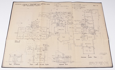
Work on paper - Document, plans, Alterations and additions to Stanhope Legacy Childrens' Hostel, Parts .2) and .3) 19.2.46. Parts .4) and .5) August 50
Detailed plans for the redevelopment of the Stanhope Childrens Hostel and Staff Accomodation.Melbourne Legacy established residences to aid children of deceased servicemen complete their education, take further education and find employmentEnvelope containing various Stanhope Residence plans and written history. 00042.1) beige coloured envelope with ’Stanhope Residence’ handwritten on front. 00042.2) Drawn plan ‘Alterations and Additions to Stanhope Legacy Childrens Hostel’ ‘Sheet No 1’ 00042.3) Drawn plan ‘Alterations and Additions to Stanhope Lecacy Childrens Hostel’ ‘Sheet No 2’ 00042.4) Drawn Plan ‘Staff Accomodation Stanhope’. 00042.5) ‘Plan of Drainage’ Stanhope. 00042.6) Short written account of Stanhope History 00042.7) Typed transcript of short written account of Stanhope history.residences, properties, stanhope -
Ringwood and District Historical Society
Plans, Education Department Victoria, Ringwood State School No 2997: Original Plans of proposed works from 1921 to 1992, 1931 to 1992
The Ringwood Primary School opened in Ringwood Street on 2nd November 1889 and eventually moved to Greenwood Avenue in 1921. These plans apply to the Greenwood Avenue location. The school closed in the 1990s.Forty two original plans of proposed works at Ringwood State School No. 2997. The dates vary from 1921, the first building, to 1992. Most of the plans are building plans for extensions or upgrades. -
Port Melbourne Historical & Preservation Society
Plan - Proposed footbridge over the Lagoon, Bridge Street, Port Melbourne, 1863
Plan of proposed footbridge over the Lagoon in line of Bridge StreetIn ink on reverse, two small drawings: elevation land view over a distance of 25.00 chains (colour tinted), and Plan view, section of an unidentified street:In pencil on reverse, notation '107 Albert Street'sandridge lagoon, robert h morgan -
 Peterborough History Group
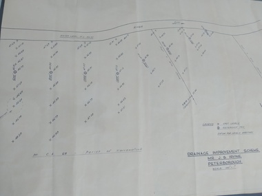
Plan, Drainage Improvement Scheme. Mr J.S. Irvine. Peterborough
Assumed to be a plan of the drainage at The Lodge farmIndication of land levels c1970Professionally drawn plan of drainage scheme for J. S. Irvine.the lodge farm, drainage plan, j. s. irvine -
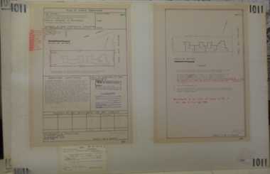 Greensborough Historical Society
Planning document, Subdivision Plan #1011. Corner Mountainview Road and Hume Streets, 1981_
Plan of Strata Subdivision for units at corner of Mountainview Road and Hume Street Briar Hill.An example of hard copy subdivision plans from the Greensborough area. Mainly from the Shire of Diamond Valley era (1964-1994).Plan (2 sheets) mounted on heavy card.Stamped and handwritten Council permissions, dates and other details.subdivision plans, mountainview road, hume street -
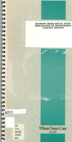 Greensborough Historical Society
Booklet, Wilson Sayer Core Pty Ltd, Diamond Creek retail study: preparation of development concept options, August 1989
Planning options for an extended retail development in Diamond Creek 1989.12 p. text, 12p. plans, spiral bound non-fictiondiamond creek, shire of diamond valley, retail developments -
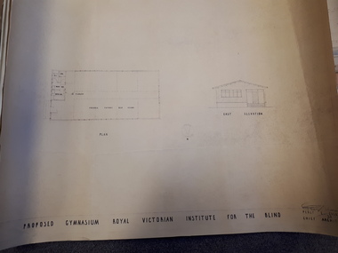 Vision Australia
Plan - Image, Proposed Gymnasium Royal Victorian Institute for the Blind, 21 June 1950
In 1951 plans were made for the construction of a gymnasium to be situated in the grounds of St Kilda Road. These 4 plans specify the building construction notes, present front and east elevations, and show how part of the hall could be transformed into bedrooms in the future. There are 2 copies of each plan, consisting of identifical copies of the east elevation and different notes printed/handwritten on the front, side and top elevations. These were presented to the RVIB Board in Feburary 1951, according to the stamp on the back.2 architectural plans showing proposed gymnasium buildingPercy E Everett Chief Architectroyal victorian institute for the blind, plans -
 Greensborough Historical Society
Poster - Planning Document, Shire of Diamond Valley et al, Subdivision Plan # 1026 - Parish of Nillumbik, County Bourke, Crown Allotment B Section 12, Eltham North, 1981-1984
Subdivision Plan # 1026 - Parish of Nillumbik, County Bourke, Crown Allotment B Section 12, Eltham North. This subdivision plan includes Ryans Road (also known as Government Road) and St Clems Street. The developer for this subdivision is Taunton Developments and the Surveyors are Fisher Cleeland Turner & Dwyer Vic, Surveyors and Engineers.An example of hard copy subdivision plans from the Greensborough area. Mainly from the Shire of Diamond Valley era (1964-1994).Plan (single sided) mounted on heavy card. Stamped and handwritten Council permissions, dates and other details. subdivision plans, shire of diamond valley, taunton developments -
 Kew Historical Society Inc
Plan, Melbourne & Metropolitan Board of Works : Borough of Kew : Detail Plan No.1565, 1905
The Melbourne and Metropolitan Board of Works (MMBW) plans were produced from the 1890s to the 1950s. They were crucial to the design and development of Melbourne's sewerage and drainage system. The plans, at a scale of 40 feet to 1 inch (1:480), provide a detailed historical record of Melbourne streetscapes and environmental features. Each plan covers one or two street blocks (roughly six streets), showing details of buildings, including garden layouts and ownership boundaries, and features such as laneways, drains, bridges, parks, municipal boundaries and other prominent landmarks as they existed at the time each plan was produced. (Source: State Library of Victoria). This plan forms part of a large group of MMBW plans and maps that was donated to the Society by the Mr Poulter, City Engineer of the City of Kew in 1989. Within this collection, thirty-five hand-coloured plans, backed with linen, are of statewide significance as they include annotations that provide details of construction materials used in buildings in the first decade of the 20th century as well as additional information about land ownership and usage. The copies in the Public Record Office Victoria and the State Library of Victoria are monochrome versions which do not denote building materials so that the maps in this collection are invaluable and unique tools for researchers and heritage consultants. A number of the plans are not held in the collection of the State Library of Victoria so they have the additional attribute of rarity.Original survey plan, issued by the MMBW to a contractor with responsibility for constructing sewers in the area identified on the plan within the Borough of Kew. The plan was at some stage hand-coloured, possibly by the contractor, but more likely by officers working in the Engineering Department of the Borough and later Town, then City of Kew. The hand-coloured sections of buildings on the plan were used to denote masonry or brick constructions (pink), weatherboard constructions (yellow), and public buildings (grey). MMBW Plan No.1565 is an example of a plan where a number of streets have been created since the area was surveyed, or in other cases renamed. The plan shows those streets that were bordered by Ross Street, Mount Street, Sackville Street and Burke Road. Since 1905, Mawson Street has been created and Mont Albert Road renamed as Dean Street. Named houses on the plan include ‘Tyrol’, ‘Glengorse’, ‘Theodore Villa’, ‘Arncliffe’, ‘Ballynira’ and ‘Hazeldene’. The plan also shows a Wesleyan Church in Sackville Street. In 1883, the Church’s Sunday School celebrated its silver anniversary.melbourne and metropolitan board of works, detail plans, mmbw 1565, cartography -
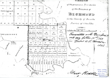 University of Melbourne, Burnley Campus Archives
Plan - Photocopy, Sketch of the Proposed Boundaries of the Village of Richmond, 1843
Sketch of the proposed boundaries of the village of Richmond in the County of Bourke Parish of Jika-Jika. Handwritten on original: "Transmitted with Description and my letter No 43/150 Dated 11th November 1843 Robert Hoddle." Shows Burnley Gardens site as "Reserve. Survey Department." original in Central Plan Office, Department of Natural Resources and EnvironmentIn ink: From Central Plan Office Dept. Nat. Resources & Environmentrichmond, jika-jika, survey department, yarra river, robert hoddle -
 Vision Australia
Plan - Image, Proposed additional nurses bedroom to "Myer Home" existing nursery, Blind Institute, St Kilda Rd, 23/8/1949
In 1949 an architect produced this plan to detail the addition of a bedroom for the nursing staff, who looked after children in the Blind Babies nursery. The plan shows a layout of the RVIB site, including the 'Myers Home' (the name of the nursery) where young children were cared for. The south and eastern elevations are detailed, as well as a plan of the nursery, which had 4 bedrooms, a living room, a dinning room , bathroom, 2 kitchen areas and the proposed additional nurses bedroom next to Bedroom 4.1 architectural plan of Myer House and proposed extensionPercy E Everett, Chief Architectroyal victorian institute for the blind, rvib nursery, plans, myer house -
Port Melbourne Historical & Preservation Society
Plan - Proposed Bayside development, Aug 1987
SCDC plans for the Bayside development were revised as investigations into water circulation in artifical canals/harbour were completed. This is the plan as originally proposed prior to the EES hearing in September 1987.Large plan of original proposed Bayside development as submitted to council in 1987town planning - proposals shelved - bayside, sandridge city development co pty ltd, scdc -
Port Melbourne Historical & Preservation Society
Plan, "State Bank of Victoria - Proposed dwelling Fishermans Bend"
Plans were brought to us for copying 19.05.2011 by CBA employee Steve Tserkezidis, who has access to old State Bank records. Borrowed for scanning by Gavin Rowson who put them on CD and returned 07.06.2011From series of State Bankhouse plans and elevations of types 1 - 8. A1 copies (.01) 1937 (stamp). (.02) 1928. (.03) 1937. (.04) 1937. (.05) no date. (.06) 1928. (.07) 1937. (.08) 1938. From plans accompanying bank House plans .01 to .08; (.09) MMBW plan showing bank properties (.10) Bank house plan: sections through walls. (.11) "Fishermans bend group" plan of properties (.12) Bank House plan of Pier Foundationgarden city, built environment - domestic, state savings bank of victoria, bank houses -
 Greensborough Historical Society
Poster - Planning Document, Shire of Diamond Valley et al, Subdivision Plan # 1018 - Parish of Nillumbik, County Bourke, Crown Allotment 4 Section 15, and Crown Allotment B Section 12, Eltham North, 1981-1982
Subdivision Plan # 1018 - Parish of Nillumbik, County Bourke, Crown Allotment 4 Section 15, and Crown Allotment B Section 12, Eltham North. This subdivision plan includes Ryans Road (also known as Government Road) and St Clems Street. The developer for this subdivision is Taunton Developments and the Surveyors are Fisher Cleeland Turner & Dwyer Vic, Surveyors and Engineers.An example of hard copy subdivision plans from the Greensborough area. Mainly from the Shire of Diamond Valley era (1964-1994).Plan (single sided) mounted on heavy card. Stamped and handwritten Council permissions, dates and other details. subdivision plans, shire of diamond valley, taunton developments -
 Kew Historical Society Inc
Plan, Melbourne & Metropolitan Board of Works : Borough of Kew : Detail Plan No.1571, 1904
The Melbourne and Metropolitan Board of Works (MMBW) plans were produced from the 1890s to the 1950s. They were crucial to the design and development of Melbourne's sewerage and drainage system. The plans, at a scale of 40 feet to 1 inch (1:480), provide a detailed historical record of Melbourne streetscapes and environmental features. Each plan covers one or two street blocks (roughly six streets), showing details of buildings, including garden layouts and ownership boundaries, and features such as laneways, drains, bridges, parks, municipal boundaries and other prominent landmarks as they existed at the time each plan was produced. (Source: State Library of Victoria)This plan forms part of a large group of MMBW plans and maps that was donated to the Society by the Mr Poulter, City Engineer of the City of Kew in 1989. Within this collection, thirty-five hand-coloured plans, backed with linen, are of statewide significance as they include annotations that provide details of construction materials used in buildings in the first decade of the 20th century as well as additional information about land ownership and usage. The copies in the Public Record Office Victoria and the State Library of Victoria are monochrome versions which do not denote building materials so that the maps in this collection are invaluable and unique tools for researchers and heritage consultants. A number of the plans are not held in the collection of the State Library of Victoria so they have the additional attribute of rarity.Original survey plan, issued by the MMBW to a contractor with responsibility for constructing sewers in the area identified on the plan within the Borough of Kew. The plan was at some stage hand-coloured, possibly by the contractor, but more likely by officers working in the Engineering Department of the Borough and later Town, then City of Kew. The hand-coloured sections of buildings on the plan were used to denote masonry or brick constructions (pink), weatherboard constructions (yellow), and public buildings (grey). This plan is the other half of Plan No.1571 representing the constructions to the west of Wellington Street before and in 1903/4. This plan represents the built environment in Edgevale Road, Wellington Street, Atkins Street, Annadale Street, Mortimer Street, and Cotham Road. Whereas there are smaller allotments and more modest housing stock facing Edgevale Road, larger blocks and more substantial houses are represented facing Cotham Road.melbourne and metropolitan board of works, detail plans, mmbw 1571, cartography -
 Kew Historical Society Inc
Plan, Melbourne & Metropolitan Board of Works : Borough of Kew : Detail Plan No.1575, 1905
The Melbourne and Metropolitan Board of Works (MMBW) plans were produced from the 1890s to the 1950s. They were crucial to the design and development of Melbourne's sewerage and drainage system. The plans, at a scale of 40 feet to 1 inch (1:480), provide a detailed historical record of Melbourne streetscapes and environmental features. Each plan covers one or two street blocks (roughly six streets), showing details of buildings, including garden layouts and ownership boundaries, and features such as laneways, drains, bridges, parks, municipal boundaries and other prominent landmarks as they existed at the time each plan was produced. (Source: State Library of Victoria)This plan forms part of a large group of MMBW plans and maps that was donated to the Society by the Mr Poulter, City Engineer of the City of Kew in 1989. Within this collection, thirty-five hand-coloured plans, backed with linen, are of statewide significance as they include annotations that provide details of construction materials used in buildings in the first decade of the 20th century as well as additional information about land ownership and usage. The copies in the Public Record Office Victoria and the State Library of Victoria are monochrome versions which do not denote building materials so that the maps in this collection are invaluable and unique tools for researchers and heritage consultants. A number of the plans are not held in the collection of the State Library of Victoria so they have the additional attribute of rarity.Original survey plan, issued by the MMBW to a contractor with responsibility for constructing sewers in the area identified on the plan within the Borough of Kew. The plan was at some stage hand-coloured, possibly by the contractor, but more likely by officers working in the Engineering Department of the Borough and later Town, then City of Kew. The hand-coloured sections of buildings on the plan were used to denote masonry or brick constructions (pink), weatherboard constructions (yellow), and public buildings (grey). Plan No.1575 shows that in the area bounded by Wellington Street, Edgevale Road, Glenferrie Road, and Cotham Road, there had already been significant subdivision of land and houses constructed. As one of the highest points in Kew, as expected, there were already some significant mansions built on large allotments of land. Many of these mansions are identified by name on the plan such as ‘Kelso’, ‘Abbotsford’, ‘Clarendon’ and ‘Ashlyn’ in Cotham Road. Other houses of equal size are unnamed on the plan.melbourne and metropolitan board of works, detail plans, maps - borough of kew, mmbw 1575, cartography -
Clunes Museum
Book, LANDCARE MANAGEMENT, 1998
ULLINA LAND CARE GROUP LANDCARE MANAGEMENT PLAN. FUNDED BY NATIONALLAND CARE PLAN. AUGUST 1998. PRINCIPAL CONSULTANT THOMSON HAY & ASSOCIATES PTY LTD.SPRING METAL BOUND BOOK - ULLINA LANDCARE GROUP LAND AND MANAGEMENT PLAN.local history, book, reference, landcare -
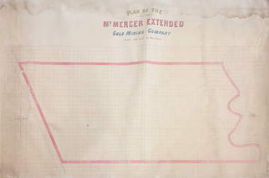 Federation University Historical Collection
Plan, Plan of the Mount Mercer Extended Gold Mining Company
This plan is associated with former Ballarat School of Mines Student Richard Squire (1875-1876). Gift of the Squire FamilyPaper on linen large plan. Hand coloured.mount mercer, gold mining, squire's, gold, mining, plan -
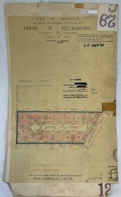 Greensborough Historical Society
Poster - Planning Document, City of Heidelberg, Subdivision Plan # G 29 Part 2, Crown portion 16, Greensborough, 1951
Plan of Subdivisions in City of Heidelberg: Parish of Keelbundoora: Crown portion 16 - Daours Court and Devonshire Road, 1951.An example of hard copy subdivision plans from the Greensborough area. Mainly from the Shire of Diamond Valley era (1964-1994).Plan (single sided) mounted on heavy card. Stamped and handwritten Council permissions, dates and other details.subdivision plans, city of heidelberg -
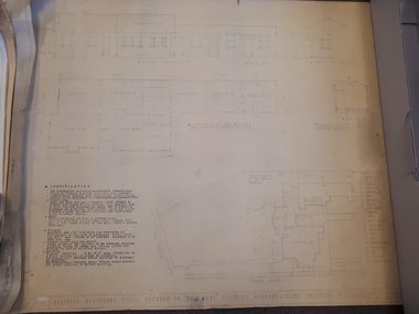
 Federation University Historical Collection
Booklet - Report, Report and Recommendations to the Council of the School of Mines and Industries, Ballarat on the Master Plan for the Mt Helen Development, 11/1968
A master plan for the campus was developed by L.H. Vernon and Associates. Geoff J. Harrison prepared a report and made recommendations on the master plan, including suggestions for improvement. Grey card covered, stapled, foolscap report on the Mount Helen Development. It included 14 typed pages and 6 plans. The report covers: Campus planning, Mt Helen Master Plan, retention of trees, sports fields, student accommodation, student amenities, library, car parking, site, landscape, land use study, Mt Helen Site, L.H. Vernon.mount helen master plan, masterplan, master plan, vernon, g.j. harrison, harrison, education, topography, survey, jd fisher, aa jeffreys, hugh mitchell, john vernon, geoff harrison, mount helen master plan, l.h. vernon, campus plan, mount helen campus -
Clunes Museum
Document - BUSINESS PLAN, 2007
PREPARED FOR THE CREATIVE CLUNES WORKING PARTY UNDER THE AUSPICES OF THE CLUNES TOURIST AND DEVELOPMENT ASSOCIATION INC WITH FUNDING FROM THE DEPT OF PLANNING & COMMUNITY DEVELOPMENT BY VISION BUSINESS CONSULTING, NOVEMBER 2007BUSINESS PLAN FOR CREATIVE CLUNESlocal history, documents, plans, -
 Eltham District Historical Society Inc
Book, D. Pendavingh, Yarra River Trail Plan 1989: Banksia Street to Warrandyte, 1989
Also contains a loose A3 mylar plan inserted - Depart of Planning and Urban Growth, Heidelberg; Main Yarra Trail; Warringal Parklands and Banyule Flats, Detail Plan and Locality Plan -
 Greensborough Historical Society
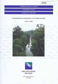
Pamphlet, Lower Plenty River concept plan, summary report: Maroondah Pipetrack to Yarra River, 1992_07
This draft concept plan covers the lower Plenty River from the Maroondah Pipe track in Greensborough to where the Plenty meets the Yarra. Melbourne Water was the lead agency, assisted by the Shires of Eltham and Diamond Valley, City of Heidelberg, the EPA and Department of Planning and Housing.Coloured pamphlet, photograph and plans 12 pages. 2 copies.plenty river, maroondah aqueduct, melbourne water -
Whitehorse Historical Society Inc.
Article, Plans costed, 1992
Estimated cost of developing historic Matheson's Orchard is $276,000.Estimated cost of developing historic Matheson's Orchard is $276,000. Consultants recommend a five year restoration plan. The Forward Planning Committee voted to form an advisory Committee to help Council program the works, conservation and promotion of the property.Estimated cost of developing historic Matheson's Orchard is $276,000.orchards, matheson, charles, city of nunawading, matheson orchard -
Bialik College
Document (Sub-series) - Architect Ron Unger's papers relating to Shakespeare Grove
... planning ...construction, buildings, planningconstruction, buildings, planning -
Port Melbourne Historical & Preservation Society
Plan - Proposed Bayside development, Sep 1987
SCDC plans for the Bayside development were revised as investigations into water circulation in artifical canals/harbour were completed. This is the altered plan, with alterations drawn in red on the original proposal, for the EES hearing in September 1987. The EES hearing, scheduled for three days in September, ran for 57 sessions into February 1988.Large plan of original proposed Bayside development as submitted to council in 1987; as 502.01 but with alterations superimposed in red, It was this altered plan that was submitted at the enquiry into the Environmental Effects Statement in September.In blue: EES Variation September 1987:In red: markings to indicate alterations to land configurationtown planning - proposals shelved - bayside, sandridge city development co pty ltd, scdc